HomeDiagramsDatabaseMapsForum About
     

Go Back   SkyscraperPage Forum > Photography Forums > Found City Photos

Reply

 
Thread Tools Display Modes
     
     
  #19461  
Old Posted Feb 8, 2014, 10:41 PM
Tourmaline Tourmaline is offline
Registered User
 
Join Date: May 2012
Posts: 996
Quote:
Originally Posted by Flyingwedge View Post
With the Winter Olympics underway, let's look back to some photos -- mostly of the Olympic Village in Baldwin Hills -- from the Official Report of the 1932 Summer Games in Los Angeles, which is available online here: http://olympic-museum.de/o-reports/report1932.htm
On the subject of the LA '32 Olympics, perhaps the Mary Hall Atwood illustrated map is the best. It was previously posted by sopas ej. http://forum.skyscraperpage.com/show...4&postcount=28 Without any intention of offending, on an historically accurate albeit sensitive subject, I wonder why it was necessary to include a "certain" Slough near Gardena. Not aware that it had any relevancy to any Olympic venues. Or was it possibly near the route of the Marathon?

A large version is available at LAPL, => http://www.lapl.org/sites/default/fi...ps/map0046.jpg
Reply With Quote
     
     
  #19462  
Old Posted Feb 8, 2014, 11:01 PM
Tourmaline Tourmaline is offline
Registered User
 
Join Date: May 2012
Posts: 996
Quote:
Originally Posted by MichaelRyerson View Post
At first I thought it was 'Bob's' but it's obviously not on Wilshire...


Exterior view of an unidentified airplane-shaped gas station, ca.1925-1939

'Photograph of an exterior view of an unidentified airplane-shaped gas station, ca.1925-1939. An unidentified gas station is shown at center, shaped like (and possibly built from) a small airplane. The wing in the foreground of the image is supported by columns that sit in front of the fuel bay. The rear of the airplane reads "Royal Albatross". A sign on a post in the left foreground reads "Good Rich", while a building at the right edge of the image reads "Paul A [¿]". Hills are visible in the right background.'

USCdigital archive/Title Insurance and Trust / C.C. Pierce Photography Collection, 1860-1960

And although it's from the C.C. Pierce collection it doesn't seem like a Pierce exposure to me.
Per LAPL:
Quote:
View of the Royal Albatross, an airplane used as a service station, located on the eastern vertex of a narrow strip of land bordered by Ventura Boulevard (south), Ventura Place (north, seen here, foreground) and Laurel Canyon Boulevard (west). Gasoline pumps are set up under the wing spans. Photograph dated March 31, 1939.
http://jpg2.lapl.org/pics46/00057745.jpg
Reply With Quote
     
     
  #19463  
Old Posted Feb 8, 2014, 11:02 PM
Tourmaline Tourmaline is offline
Registered User
 
Join Date: May 2012
Posts: 996
Quote:
Originally Posted by HossC View Post
They're still there today, unlike Simon's Drive-In and the La Fayette Apartments .


Google Maps


I found this better view in one of the pictures I linked to. It was just across Rampart Boulevard from the Hershey Arms. I'd guess at gas station, although I can only read the word "Associated".

One of the billboards says "Proposition 10 will ruin our beaches!" - does anyone know what this is about?


Detail of picture at USC Digital Library

Thanks for the follow-up and clearing up what I thought was an optical illusion!

Other "Associated" stations:

Circ '37-'38(?) Unknown location
http://jpg1.lapl.org/00102/00102226.jpg

1941 - Wilshire near Mansfield (Wonder about the sign to the right: "Norwalk."
http://jpg1.lapl.org/00104/00104585.jpg
Reply With Quote
     
     
  #19464  
Old Posted Feb 8, 2014, 11:19 PM
Chuckaluck Chuckaluck is offline
Registered User
 
Join Date: Apr 2012
Posts: 649
Quote:
Originally Posted by tovangar2 View Post
1932, The Darkroom/Chandler's building (SE corner Wilshire and Cloverdale) is still Spanish Colonial Revival. Dyas-Carlton Cafe Building lower right corner next to a Standard Station:


La Brea near Sycamore (South of Wilshire) - notice a certain twin-masted Dominguez Wilshire Building in the background (right).

January 1941 - How fresh is your mayonnaise?
http://jpg1.lapl.org/00104/00104583.jpg
Reply With Quote
     
     
  #19465  
Old Posted Feb 8, 2014, 11:20 PM
ethereal_reality's Avatar
ethereal_reality ethereal_reality is offline
Registered User
 
Join Date: Feb 2008
Location: Lafayette/West Lafayette IN, Purdue U.
Posts: 16,352
an astonishing view of the set from Ben-Hur. August 18, 1925 (under construction)
ebay

The enormous chariot race arena was constructed at what is now the intersection of La Cienega and San Vicente Boulevards.


http://wallacestudy.blogspot.com/201...lent-film.html


photographer's stamp on the aerial photograph (there's one on the front as well, lower left hand corner)

Last edited by ethereal_reality; Feb 8, 2014 at 11:33 PM.
Reply With Quote
     
     
  #19466  
Old Posted Feb 8, 2014, 11:23 PM
GaylordWilshire's Avatar
GaylordWilshire GaylordWilshire is offline
Registered User
 
Join Date: Nov 2009
Location: NYC
Posts: 3,703
Quote:


Re the various recent shots around and above the vicinity of Wilshire and Hoover... the house below, 2902 Wilshire, was on the site of Simon's...


And below, looking westward from Hoover beginning with a partial view of 2902 at left, are 2914, 2920, 2932 (the white one), 2942 and, at the end, 2966.

Huntington

The house just out of the frame at right is 2976...which is a rare survivor.
Reply With Quote
     
     
  #19467  
Old Posted Feb 8, 2014, 11:33 PM
Chuckaluck Chuckaluck is offline
Registered User
 
Join Date: Apr 2012
Posts: 649
Highland Tower Apt. Building and Wonder Super Market. (Highland and Franklin previously featured in this thread. )


November 1944
http://jpg1.lapl.org/00104/00104368.jpg


Goodbye Wonder Super Market, hello mini mall and parking lot!
http://50.6.140.129/images/hollywood...apr%201990.jpg

http://farm5.staticflickr.com/4029/4...16e71b09f9.jpg
Reply With Quote
     
     
  #19468  
Old Posted Feb 8, 2014, 11:45 PM
GaylordWilshire's Avatar
GaylordWilshire GaylordWilshire is offline
Registered User
 
Join Date: Nov 2009
Location: NYC
Posts: 3,703
Quote:
Originally Posted by Tourmaline View Post
1941 - Wilshire near Mansfield (Wonder about the sign to the right: "Norwalk."
http://jpg1.lapl.org/00104/00104585.jpg

The Vogue Tyre 3D billboard reminds me of a couple of prior pics here--


(Can't find the original post itself)

and


seen here before in post #10205
Reply With Quote
     
     
  #19469  
Old Posted Feb 8, 2014, 11:45 PM
Tourmaline Tourmaline is offline
Registered User
 
Join Date: May 2012
Posts: 996
Quote:
Originally Posted by gsjansen View Post


air raid sirens

wilshire and western 1952


Source: USC Digital Archive

burbank public service building 1956


Source: USC Digital Archive

van nuys city hall 1951


Source: USC Digital Archive

federal building 1954


Source: LAPL

july 4th 1951

Children plug their ears in anticipation of an air raid siren going off. "Ooooo! is the way the Hubik children -- Julius, 6; Suerita, 10, and Margie, 7 -- voiced their reaction today to the wailing of Los Angeles' air raid sirens and ringing of church bells at noon as glorious Fourth of July was celebrated in observance of 175th anniversary of signing of the Declaration of Independence. The blast also served as a country-wide test for the air raid sirens". "Braced for warning of biggest A-bomb test in desert. Young and old alike in Los Angeles are poised for 'It could happen here day' as historic A-bomb nears target; sirens will sound 10 minutes before drop".


Source: LAPL

Apartment residents must have appreciated all nearby air raid testing. What!? What!?

Nov. '58, 11th and Burlington
http://jpg2.lapl.org/pics46/00057680.jpg
Reply With Quote
     
     
  #19470  
Old Posted Feb 9, 2014, 12:22 AM
Chuckaluck Chuckaluck is offline
Registered User
 
Join Date: Apr 2012
Posts: 649
Quote:
Originally Posted by ethereal_reality View Post

usc digital archive
Different direction (looking east) and perspective.

1940
http://jpg1.lapl.org/00104/00104338.jpg


January 1950
http://jpg1.lapl.org/00104/00104339.jpg


1942 - Switzer's, Texaco and a smidgen of Chesterfield.
http://jpg3.lapl.org/pics37/00068476.jpg
Reply With Quote
     
     
  #19471  
Old Posted Feb 9, 2014, 12:25 AM
ethereal_reality's Avatar
ethereal_reality ethereal_reality is offline
Registered User
 
Join Date: Feb 2008
Location: Lafayette/West Lafayette IN, Purdue U.
Posts: 16,352
Sometimes you see something that's equivalent to sticking needles in your eyes.

this is one.

3rd and S. Union Ave.

-google street view-

__
Reply With Quote
     
     
  #19472  
Old Posted Feb 9, 2014, 12:42 AM
Chuckaluck Chuckaluck is offline
Registered User
 
Join Date: Apr 2012
Posts: 649
Quote:
Originally Posted by HossC View Post
The picture was taken near the intersection of Wilshire and Serrano Avenue. Fashion Trends Beauty Salon was at 3717 Wilshire (1956 CD). The picture below is dated 1930/1940.


USC Digital Library

That block is now the location of Chase Bank and Pacific City Bank.

http://forum.skyscraperpage.com/show...ostcount=19126


Same corner of Wilshire and Western?

Source indicates 1930 without a location.
http://jpg2.lapl.org/spnb2/00017593.jpg
Reply With Quote
     
     
  #19473  
Old Posted Feb 9, 2014, 12:44 AM
ethereal_reality's Avatar
ethereal_reality ethereal_reality is offline
Registered User
 
Join Date: Feb 2008
Location: Lafayette/West Lafayette IN, Purdue U.
Posts: 16,352
I couldn't help but notice the TWA billboard.

posted by Chuckaluck


The 'Connie' is one of my favorite vintage passenger plane.

http://www.sedonalegendhelenfrye.com/1944.html


TWA Connies at LAX 1956

click here: http://www.youtube.com/watch?v=UNQusf5XlGk

__

Last edited by ethereal_reality; Feb 9, 2014 at 1:22 AM.
Reply With Quote
     
     
  #19474  
Old Posted Feb 9, 2014, 12:50 AM
HossC's Avatar
HossC HossC is offline
Registered User
 
Join Date: Aug 2013
Posts: 4,245
Quote:
Originally Posted by Tourmaline View Post
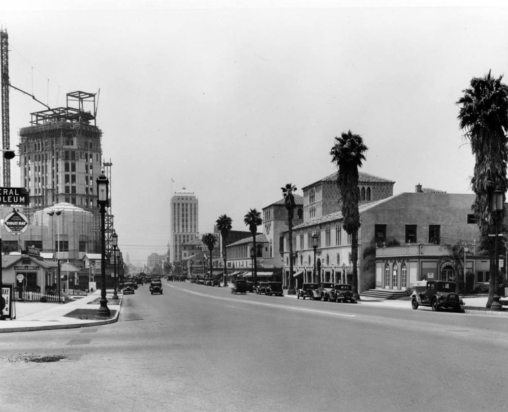
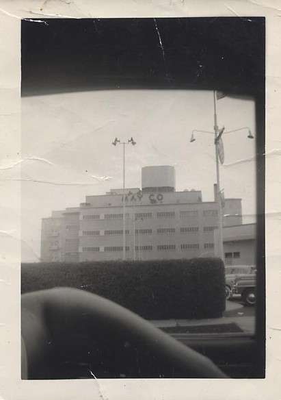
Looks like construction work to me. More Wilshire beautification. Notice barricade closest to the camera. To its right is another barricade that seems flat on the ground near where a tree or something botanical might be planted.

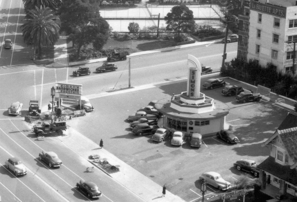
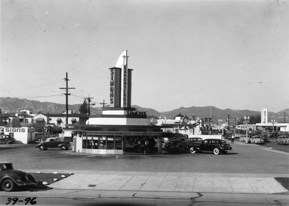
At bottom right hand of image is a sign for an overnight stop. The appearance of "Lanes" directly above, is that the name of the establishment, the proprietor, or an ad for a nearby bowling alley?
Thanks for pointing out the barricades - they would certainly suggest construction of some sort.

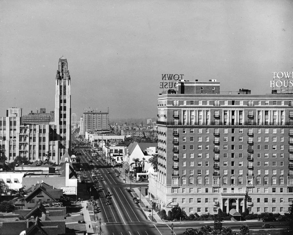
I found the source for my original picture, and went back to check the lower right corner. The "Over Night Stop" is a hotel. To me the sign looks like "Norman & Lanes", but it's not very clear. Wikimedia dates the picture at 1945. After looking at GW's post (above) and comparing rooflines, I'd say it's 2920 Wilshire.


Detail of picture at wikimedia.org

Quote:
Originally Posted by Tourmaline View Post
Thanks for the follow-up and clearing up what I thought was an optical illusion!
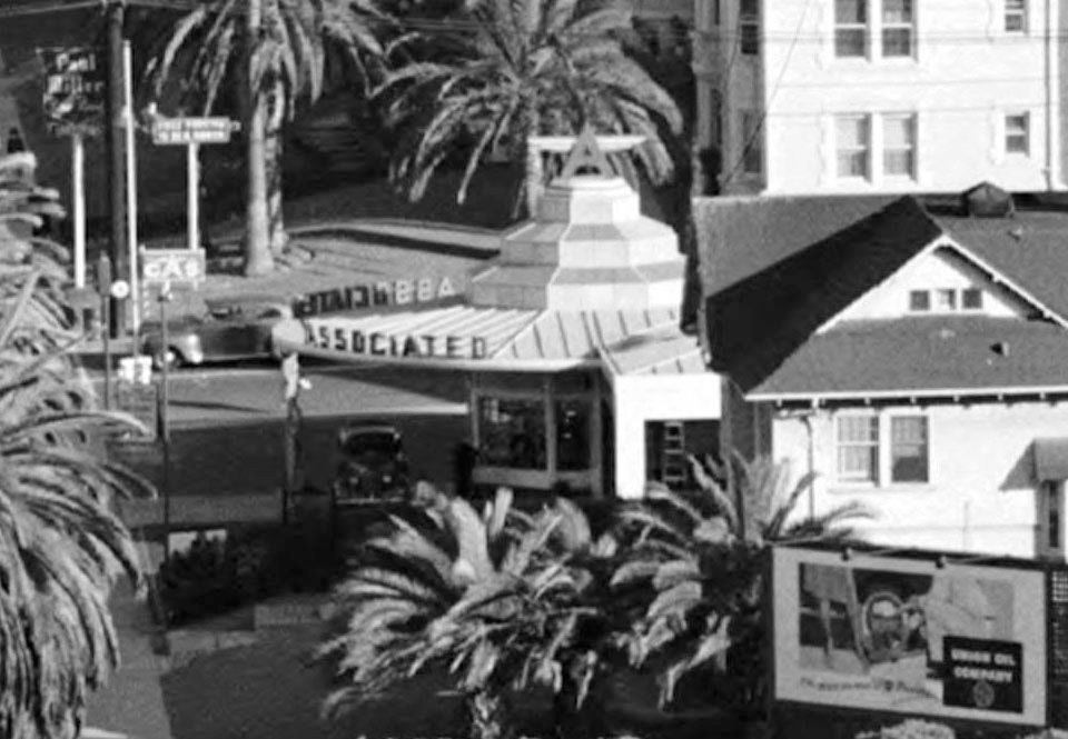
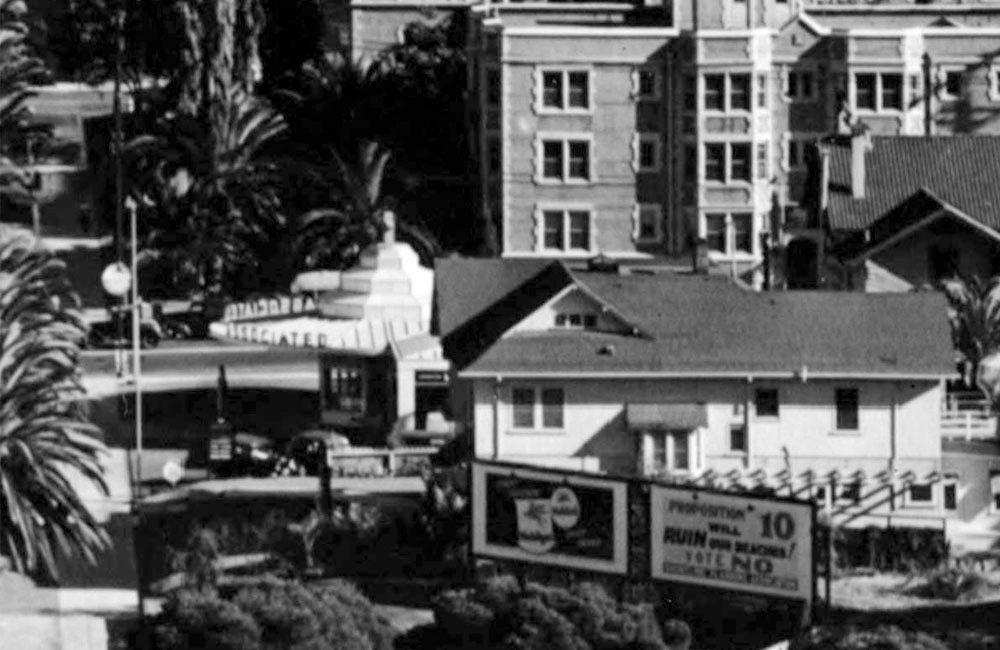
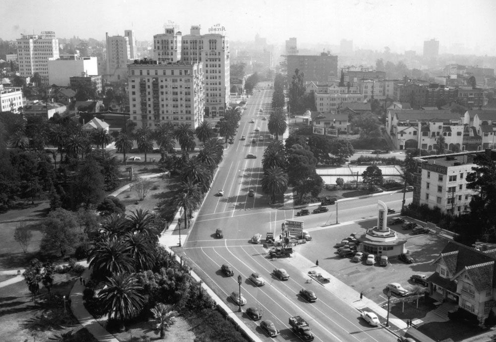
I kept looking and came across an even better view. It shows the Associated gas station with the "A" logo on the roof and "GAS" sign at the corner.


Detail of picture at USC Digital Library
Reply With Quote
     
     
  #19475  
Old Posted Feb 9, 2014, 12:51 AM
Chuckaluck Chuckaluck is offline
Registered User
 
Join Date: Apr 2012
Posts: 649
Quote:
Originally Posted by BifRayRock View Post
Two photos of Simons at Wilshire and Fairfax that are best viewed together.

Previously posted here: http://mail.hostomega.com/showpost.p...&postcount=561 and here: http://forum.skyscraperpage.com/show...170279&page=11 and


1938 (Pre-MayCo.)


1939


___________________________

http://forum.skyscraperpage.com/show...postcount=1671

1939 In transition. (Don't recall seeing this image on this thread before. The others, yes.
http://jpg1.lapl.org/00101/00101655.jpg

http://imageshack.us/a/img33/8980/aa...ayoriginal.jpg

http://farm7.staticflickr.com/6220/6...448598c0_b.jpg

http://forum.skyscraperpage.com/show...postcount=9112

1940(?)
http://jpg1.lapl.org/00102/00102036.jpg

1947
http://jpg1.lapl.org/00104/00104330.jpg


USC Digital

Last edited by Chuckaluck; Feb 9, 2014 at 3:33 AM.
Reply With Quote
     
     
  #19476  
Old Posted Feb 9, 2014, 12:58 AM
Chuckaluck Chuckaluck is offline
Registered User
 
Join Date: Apr 2012
Posts: 649

Last edited by Chuckaluck; Feb 9, 2014 at 1:16 AM.
Reply With Quote
     
     
  #19477  
Old Posted Feb 9, 2014, 1:07 AM
Chuckaluck Chuckaluck is offline
Registered User
 
Join Date: Apr 2012
Posts: 649
Quote:
Originally Posted by Tourmaline View Post
Revisiting an earlier image.


1938 Tour bus at Wilshire and Rampart. (Will they stop at Simon's for Lunch?)
http://jpg1.lapl.org/00100/00100674.jpg
Reply With Quote
     
     
  #19478  
Old Posted Feb 9, 2014, 1:30 AM
Chuckaluck Chuckaluck is offline
Registered User
 
Join Date: Apr 2012
Posts: 649


Quote:
Originally Posted by GaylordWilshire View Post
Great catch of the steps of 3240 Wilshire, Godzilla....the painting I posted of the Cole house doesn't accurately represent the lamp base. More on the details of the southeast corner of Wilshire and New Hampshire:

USCDL/GSV

While the hydrant appears to have been replaced, the lamp base, installed along the boulevard in (and circa) 1928, appears to be the same, as does the drain. I'm not an expert on L.A. trees, their types or longevity...but I wonder if what's growing in the vintage shot could be the gnarly thing there today? No, I guess not.


USCDL/GSV


An update in 1956-57 sadly discarded the famous 22-foot-tall Wilshire Special standards and replaced them with taller shafts (34 feet) with twin mercury vapor lamps. It is my understanding that the original bases were used--and they do look the same to me--but I suppose it could be that new bases were modeled on the old.


USCDL/LA Times July 31, 1956

A stretch of the boulevard--seen here looking east from the Town House --shows both old and new lamps. The USCDL dates the photo one day before the article.


Another view of the "steps" leading to 3240 Wilshire? (Is the first vehicle pictured, driver-less? 
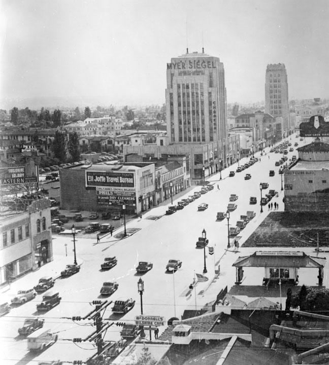
Must be morning rush hour. Notice the traffic arrangement with eastbound traffic using a lane normally used for westbound traffic.


Circa '42
http://jpg3.lapl.org/pics37/00068476.jpg
Reply With Quote
     
     
  #19479  
Old Posted Feb 9, 2014, 3:49 AM
Tourmaline Tourmaline is offline
Registered User
 
Join Date: May 2012
Posts: 996
Quote:
Originally Posted by Chuckaluck View Post
1939 In transition. (Don't recall seeing this image on this thread before. The others, yes.
http://jpg1.lapl.org/00101/00101655.jpg


Approximately twenty years earlier . . . circa 1922

http://digitallibrary.usc.edu/cdm/si...id/12541/rec/4

Rogers (mentioned several times in this thread). Largest [something] in the West!


Reply With Quote
     
     
  #19480  
Old Posted Feb 9, 2014, 6:38 AM
CityBoyDoug CityBoyDoug is offline
BANNED
 
Join Date: Apr 2013
Posts: 2,868
Another fine mess you got me into...

Quote:
Originally Posted by GaylordWilshire View Post
The Vogue Tyre 3D billboard reminds me of a couple of prior pics here--


I could be discombobulated but is that Oliver Hardy....the other half of Stan Laurel?

Edit: I was flummoxed....this is band leader Paul Whiteman..!!!

Last edited by CityBoyDoug; Feb 9, 2014 at 5:55 PM.
Reply With Quote
     
     
This discussion thread continues

Use the page links to the lower-right to go to the next page for additional posts

Reply

Go Back   SkyscraperPage Forum > Photography Forums > Found City Photos
Forum Jump


Forum Jump


All times are GMT. The time now is 11:47 AM.

     
SkyscraperPage.com - Archive - Privacy Statement - Top

Powered by vBulletin® Version 3.8.7
Copyright ©2000 - 2024, vBulletin Solutions, Inc.