HomeDiagramsDatabaseMapsForum About
     

Go Back   SkyscraperPage Forum > Discussion Forums > City Discussions


Reply

 
Thread Tools Display Modes
     
     
  #21  
Old Posted Dec 5, 2021, 1:13 PM
Beedok Beedok is offline
Exiled Hamiltonian Gal
 
Join Date: Jun 2012
Posts: 6,806
Quote:
Originally Posted by kenratboy View Post
Looking at Ottowa as an example, still strict. There are places like Barrhaven and Kanata (I am just randomly pulling those names from Google Maps, not sure if they are actual cities per se) that make it look like there are gaps, but they appear to, on their own, to also be strictly growing from the inside out...and eventually they will meet up with some of the other cities and then merge into a mega-sprawl. But if you look at the open land in between...you don't have random 500 home subdivisions sprinkled around like you would in the USA.

Agree Halifax looks more 'American', though it has some tricky geography (areas that can't be economically built on) and it looks like a lot of parkland/protected land that won't be built on. But the north end of the city is certainly more spread out than others.
Kanata and Barrhaven are all part of Ottawa. It takes a good half an hour of driving to get out of Ottawa’s city limits in some directions.
Reply With Quote
     
     
  #22  
Old Posted Dec 5, 2021, 7:05 PM
mhays mhays is offline
Never Dell
 
Join Date: Jul 2001
Posts: 19,802
Quote:
Originally Posted by biguc View Post
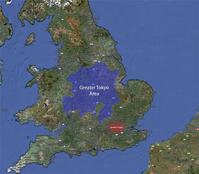
There are two things people haven't mentioned yet: amalgamations and Interstate highways.

Calgary is a great case study for the first. Calgary actually sprawls pretty aggressively, but it's almost all in Calgary. The city itself gobbles up surrounding land, services it, and sets the rules for development. If someone wants to develop a parcel of land beyond what the city is ready to service, tough shit.

American cities rarely annex or amalgamate land like this. The administrative patchwork in its stead leads to a development patchwork as multifarious communities allow this or that development.


Further down, you used an example from just outside of Winnipeg. in the '70s, Winnipeg went through a big amalgamation with most of its suburbs. The sprawl you see inside its large city limits is, therefore, orderly and characteristically Canadian. But the piece of land you've asked about is just outside city limits. The rural municipality there probably isn't capable of providing services like sewer and water to a large development. The province of Manitoba has nevertheless put it on the city to extend its water and sewer services to surrounding communities. It's not impossible that this piece of land would develop like you've illustrated, but there's another impediment: road access.

The parcel of land in question has no meaningful transportation connection to the city. In the US, there would probably be a nearby Interstate highway, which would carry drivers directly into the city. There's no such thing in Canada, and cities aren't particularly interested in building roads for residents of neighbouring municipalities to dump traffic onto. There was a recent case on the northern edge of Winnipeg where the neighbouring municipality wanted to permit a Walmart on a street only accessible through the city. It was a shameless property tax grab that would have dumped significant expenses on the city. The city kiboshed the idea by pointing out that they could close the road.

If there was a serious plan to develop the parcel you've asked about, it's likely the city would annex the area.

For what it's worth, there is a fair bit of exurban sprawl around Winnipeg. Directly north of the city looks like this:
https://www.google.com/maps/@49.9726.../data=!3m1!1e3
Very American. The municipalities there want development but are eager to maintain a rural character. It's worth noting, too, that a lot of these Mcmansions don't even have sewer services. I don't know how people who live there can enjoy their pools and huge yards when there's always a shit truck rumbling around, stinking up the place.

A similarly messy situation exists just west of the city.
https://www.google.com/maps/@49.8686.../data=!3m1!1e3

You'll notice that both of these areas have good highway connections to the city.

A lot of exurban sprawl also hides in nearby small towns. The towns are able to provide some services and they sprawl in the orderly Canadian way, just on a small scale. These towns don't have booming local economies; they're just bedroom communities.

https://www.google.com/maps/@49.6063.../data=!3m1!1e3
The takeaway from all that is that development CAN'T happen unless some major boxes are checked. That's centralized growth management.

Growth management can be "you can't build out there" or just "you can't get services out there" but the outcome is the same.

The Canadian version is a combination of both. Or at least Vancouver's is, based on a ULI presentation on the topic the other day by a Metro Vancouver rep. (In the WA/OR/BC area we share notes on growth management as a region.)
Reply With Quote
     
     
  #23  
Old Posted Dec 5, 2021, 9:16 PM
Innsertnamehere's Avatar
Innsertnamehere Innsertnamehere is offline
Registered User
 
Join Date: Jan 2010
Location: Hamilton
Posts: 11,583
I'll repost this from another recent thread:

Quote:

The way land use planning works in Ontario is that areas have to be within the "urban boundary" in order to be developed for residential or industrial uses. The province requires municipalities to have a certain amount of lands within their boundary to accommodate growth for 30 years (just upped by the conservative government to 30 from 20).

Every 10 years or so municipalities review their urban boundary, look at how existing growth areas have been absorbed, population projections, intensification rates, etc. and determine if they need to add more land.

For example, Hamilton is identified as growing from about 570,000 people today to over 820,000 in 2051 and had to decide how to accommodate that.

The planners at the City recommended accommodating 60% of it through intensification, and the remaining 40% through new suburbs. Growth in Hamilton over the last decade has been about 25% through intensification and 75% through new suburbs, so this is a substantial change.

There was a big grassroots movement from environmentalists to not expand the urban boundary and instead accommodate the 250,000 people moving to the city over the next 30 years solely through intensification.

This has regional planning implications as it will result in a huge shortage of single family homes in the market, and will likely result in growth getting pushed to other, adjacent municipalities in Brant County and Niagara. If the no-expansion-option stands, it is likely that Hamilton will fall short of it's population projections as the market will shift growth to other areas that can provide the desired product type.

The province warned the City that it would over-rule it if it implemented the no-urban-boundary-expansion option, and is likely do so now. The no-urban-boundary-expansion option clearly violates provincial planning policy which requires land to be set aside based on population projections and market demand.

I'm not sure if I'd even characterize modern Southern Ontario new suburb areas as "sprawl" anyway. The minimum densities are so high that SFDs typically account for only about 1/4 of new units in the areas, with most coming through townhouse developments and apartment buildings. They are actually very, very dense. The SFDs that do get built are on tiny lots, often smaller than inner city Toronto lots. The new areas in North Oakville show the kinds of densities required pretty well - it's a very dense form of development.

Hamilton is also already experiencing a huge building boom in it's core, where they recently implemented as of right development of 30 storey buildings across most of the downtown. By my count there are around 40 buildings over 20 storeys proposed and under construction in the downtown right now.
The reason development is so sequential (and it's not as universally sequential as you make it out to be) has to do with servicing. Most large scale servicing for new growth areas are constructed by the developers but capacity has to be released by the city for the development before they can get building permits, and the city will only release servicing allocations for lands mostly adjacent to an existing urban area and release it sequentially as development moves out from the existing urban area.
Reply With Quote
     
     
  #24  
Old Posted Dec 5, 2021, 10:02 PM
lrt's friend lrt's friend is offline
Registered User
 
Join Date: Dec 2006
Posts: 11,843
Quote:
Originally Posted by kenratboy View Post
Looking at Ottowa as an example, still strict. There are places like Barrhaven and Kanata (I am just randomly pulling those names from Google Maps, not sure if they are actual cities per se) that make it look like there are gaps, but they appear to, on their own, to also be strictly growing from the inside out...and eventually they will meet up with some of the other cities and then merge into a mega-sprawl. But if you look at the open land in between...you don't have random 500 home subdivisions sprinkled around like you would in the USA.

Agree Halifax looks more 'American', though it has some tricky geography (areas that can't be economically built on) and it looks like a lot of parkland/protected land that won't be built on. But the north end of the city is certainly more spread out than others.
Ottawa has a Greenbelt, which will not be developed. This creates the gap between the main city and the three major suburbs (Kanata, Barrhaven and Orleans), which are also part of Ottawa.
Reply With Quote
     
     
  #25  
Old Posted Dec 6, 2021, 2:28 AM
Beedok Beedok is offline
Exiled Hamiltonian Gal
 
Join Date: Jun 2012
Posts: 6,806
I still think Japan is on a whole other level for how chaotic their sprawl is.
Reply With Quote
     
     
  #26  
Old Posted Dec 6, 2021, 8:05 PM
JHikka's Avatar
JHikka JHikka is offline
ハルウララ
 
Join Date: Jul 2009
Location: Toronto
Posts: 12,853
Quote:
Originally Posted by Beedok View Post
I still think Japan is on a whole other level for how chaotic their sprawl is.
Is it? Japan is a small island filled with mountainous terrain, and Tokyo's sprawl still looks more contained than cities like Houston and LA.
Reply With Quote
     
     
  #27  
Old Posted Dec 6, 2021, 9:27 PM
mhays mhays is offline
Never Dell
 
Join Date: Jul 2001
Posts: 19,802
Japan's sprawl (if you can call it that) is extremely compact. Single-family residential blocks seem to be in the 25-per-acre range, not counting the alley-like streets, vs. 8 to 2(!) in the US. Urban fringes tend to be full of larger lots, but they're typically little farms or horticulture.
Reply With Quote
     
     
  #28  
Old Posted Dec 6, 2021, 9:29 PM
Obadno Obadno is offline
Registered User
 
Join Date: Jan 2010
Posts: 6,599
Quote:
Originally Posted by JHikka View Post
Is it? Japan is a small island filled with mountainous terrain, and Tokyo's sprawl still looks more contained than cities like Houston and LA.
Tokyo Sprawls out nearly a big as greater LA, but its because its on the largest piece of flat land in the islands, its also home to like 40 million people so that sprawl is dense but it NEVER ENDS

Tokyo feels like Brooklyn but a Brooklyn as big as the LA basin.


Guess where the Japanese cities are??

Reply With Quote
     
     
  #29  
Old Posted Dec 6, 2021, 9:37 PM
mhays mhays is offline
Never Dell
 
Join Date: Jul 2001
Posts: 19,802
Total apples and oranges.

For Tokyo you're including all the little towns and farmland in the entire basin. For London you've skipped all that.

Tokyo is far denser than London. Your photos are all of the much smaller core.
Reply With Quote
     
     
  #30  
Old Posted Dec 7, 2021, 1:58 AM
Obadno Obadno is offline
Registered User
 
Join Date: Jan 2010
Posts: 6,599
Quote:
Originally Posted by mhays View Post
Total apples and oranges.

For Tokyo you're including all the little towns and farmland in the entire basin. For London you've skipped all that.

Tokyo is far denser than London. Your photos are all of the much smaller core.
All of the farmland? have you been to Tokyo?

https://goo.gl/maps/yC7PdwvVLeja44XCA
Reply With Quote
     
     
  #31  
Old Posted Dec 7, 2021, 2:03 AM
Manitopiaaa Manitopiaaa is offline
Registered User
 
Join Date: Mar 2013
Location: Alexandria, Royal Commonwealth of Virginia
Posts: 494
Quote:
Originally Posted by Obadno View Post
All of the farmland? have you been to Tokyo?

https://goo.gl/maps/yC7PdwvVLeja44XCA
I think he means the map, where you say Tokyo is essentially Brooklyn as big as the LA Basin. Brooklyn's density is 39,000 per square mile. Only Tokyo proper (the 23 special wards) has that level of density, and that's only 242 square miles: https://www.citypopulation.de/en/jap...lr&opacity=0.8

Tokyo has lots of suburbs in the 10-20k person per square mile range, but definitely not Brooklyn-density for the entire LA basin.

Chiba Preferecture is mostly farmlands, for example, as the population hugs the Bay. Southern Ibaraki is also mostly farmlands: https://www.google.com/maps/@35.6982.../data=!5m1!1e4

Even highly urbanized preferectures like Saitama have lots of farmland: https://www.google.com/maps/@36.0788...8i6656!5m1!1e4

https://www.google.com/maps/place/Gu...499283!5m1!1e4
Reply With Quote
     
     
  #32  
Old Posted Dec 7, 2021, 3:34 PM
iheartthed iheartthed is offline
Registered User
 
Join Date: Oct 2009
Location: New York
Posts: 9,877
Interestingly, the government defined metro areas of Tokyo and New York have a fairly similar average density:

Tokyo metro: 6,814/sq mile
New York metro: 5,318/sq mile
Reply With Quote
     
     
  #33  
Old Posted Dec 7, 2021, 4:54 PM
JHikka's Avatar
JHikka JHikka is offline
ハルウララ
 
Join Date: Jul 2009
Location: Toronto
Posts: 12,853
Quote:
Originally Posted by iheartthed View Post
Interestingly, the government defined metro areas of Tokyo and New York have a fairly similar average density:
Right, and comparing this to LA or Houston leans much more favourably to Tokyo. Like, yeah, Tokyo has a ton of sprawl, but it also has a ton of people and it's all pretty dense and well-serviced...
Reply With Quote
     
     
  #34  
Old Posted Dec 7, 2021, 5:02 PM
mhays mhays is offline
Never Dell
 
Join Date: Jul 2001
Posts: 19,802
Quote:
Originally Posted by Obadno View Post
All of the farmland? have you been to Tokyo?

https://goo.gl/maps/yC7PdwvVLeja44XCA
When nothing works, double down, eh? Yes I've been to Tokyo. And I've spent many months in London (and in its extended metro you chose to exclude).

As Manitopiaaa alludes, much of the basin you're talking about is full of small farms and horticulture. Here's a typical example where the population is pretty high but much of the land is food production because everything else is extremely compact.
Reply With Quote
     
     
  #35  
Old Posted Dec 7, 2021, 5:10 PM
Acajack's Avatar
Acajack Acajack is offline
Unapologetic Occidental
 
Join Date: Aug 2006
Location: Province 2, Canadian Empire
Posts: 68,092
Land use tends to be much more efficient in places where land is more scarce.

Just like water use is more efficient in places where water is more scarce.

And so on...
__________________
The Last Word.
Reply With Quote
     
     
  #36  
Old Posted Dec 7, 2021, 5:38 PM
Obadno Obadno is offline
Registered User
 
Join Date: Jan 2010
Posts: 6,599
The urban sprawl of Tokyo and LA are fairly close in size regardless of the giant political borders of Greater Tokyo


there are farms out in riverside and Irvine too.
Reply With Quote
     
     
  #37  
Old Posted Dec 7, 2021, 6:12 PM
Doady's Avatar
Doady Doady is online now
Registered User
 
Join Date: Apr 2004
Posts: 4,721
Why show mostly ocean for LA? I'm confused.

I don't care what people say. LA is dense, it has a solid foundation for good transit if it ever finally decides to commit to it. But come on, it's still nothing compared to Tokyo.

Judging roughly from the last Tokyo image and from the parts of LA you left out, Tokyo must be half the size? And with twice the population? Four times denser? It's not even close.
Reply With Quote
     
     
  #38  
Old Posted Dec 7, 2021, 6:32 PM
Obadno Obadno is offline
Registered User
 
Join Date: Jan 2010
Posts: 6,599
Quote:
Originally Posted by Doady View Post
Why show mostly ocean for LA? I'm confused.

I don't care what people say. LA is dense, it has a solid foundation for good transit if it ever finally decides to commit to it. But come on, it's still nothing compared to Tokyo.

Judging roughly from the last Tokyo image and from the parts of LA you left out, Tokyo must be half the size? And with twice the population? Four times denser? It's not even close.
I am saying Tokyo is nearly as big of LA but with Brooklyn level density and these jokers are trying to tell me about the the small villages and farms.

I'm working with what I found online didn't make the graphic
Reply With Quote
     
     
  #39  
Old Posted Dec 7, 2021, 6:43 PM
someone123's Avatar
someone123 someone123 is offline
hähnchenbrüstfiletstüc
 
Join Date: Nov 2001
Location: Vancouver
Posts: 33,694
Tokyo is one of the densest Canadian cities. It is almost LA-level density.
Reply With Quote
     
     
  #40  
Old Posted Dec 7, 2021, 6:45 PM
mhays mhays is offline
Never Dell
 
Join Date: Jul 2001
Posts: 19,802
LA's continuously-developed core is way bigger than Tokyo's. Most people can grasp this.
Reply With Quote
     
     
This discussion thread continues

Use the page links to the lower-right to go to the next page for additional posts
 
 
Reply

Go Back   SkyscraperPage Forum > Discussion Forums > City Discussions
Forum Jump


Forum Jump


All times are GMT. The time now is 3:51 AM.

     
SkyscraperPage.com - Archive - Privacy Statement - Top

Powered by vBulletin® Version 3.8.7
Copyright ©2000 - 2024, vBulletin Solutions, Inc.