HomeDiagramsDatabaseMapsForum About
     

Go Back   SkyscraperPage Forum > Regional Sections > United States > Pacific West > Portland > Transportation & Infrastructure


Reply

 
Thread Tools Display Modes
     
     
  #1  
Old Posted Mar 26, 2008, 4:34 AM
Sekkle's Avatar
Sekkle Sekkle is offline
zzzzzzzz
 
Join Date: Aug 2006
Location: Portland area
Posts: 2,276
Your Version of Expanded Rail Service in Portland

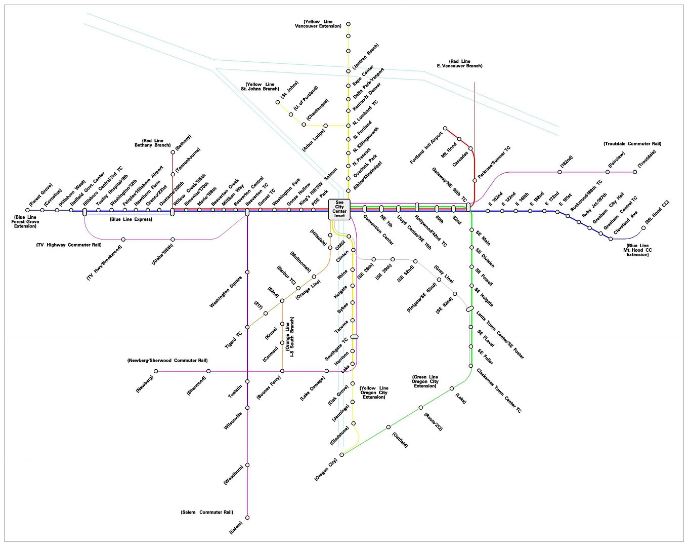
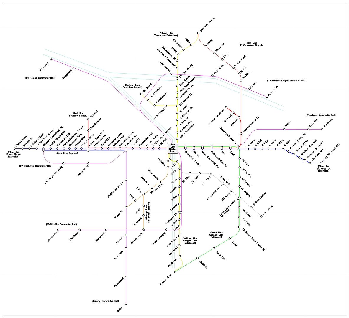
Being a civil engineer, I’m pretty interested in transportation and transit in particular (although the actual work I do usually involves more highway and street design than transit, unfortunately). I love transit maps and I’ve tried to collect as many as possible (mostly in electronic form) from cities around the world. So in my free time at work I decided to draw a map of possible future transit service in the Portland area. I started with a more geographically accurate map, but thought it might look cooler if I did a diagrammatic version. Most of the service shown in this map is either existing, in the planning or construction phase, or has been mentioned in TriMet/Metro reports (the RTP, etc). There are some, though, that I just thought would be cool, so I drew them in. Here it is (you can click on the map for a much larger version if you can’t read the text)…


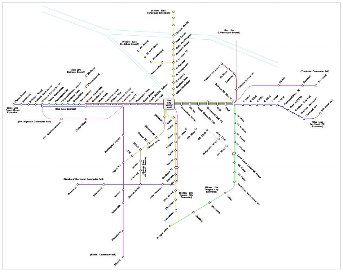
A few notes about the map…
- I didn’t include streetcar lines because I thought it would get too cluttered.

- Heavier lines indicate service that currently exists or is under construction or planning (I didn’t include the CRC in this category, but probably should have).

- Service that hasn’t reached the planning stages (and some that may never get there because I just made them up) is in a lighter line weight.

- I’m not sure if the Milwaukie LRT will actually be a yellow line extension, but I drew it that way. I’ve seen drawings that made it look like a yellow line and others that made it look orange.

- The “Orange Line” has not been chosen (as far as I’m aware) as the color for the Barbur/I-5 light rail, I just thought the map could use some orange (it looks brown in the image, but looked orange when I drew it in CAD). Same goes for the “Grey Line.”

- The Powell/Foster “Grey Line” was mentioned in the RTP as a BRT line, extending to Damascus, but I thought the map would look cooler if it were LRT to Clackamas TC.

- I drew new commuter rail lines in pink/purple.

- New stations are in parentheses.

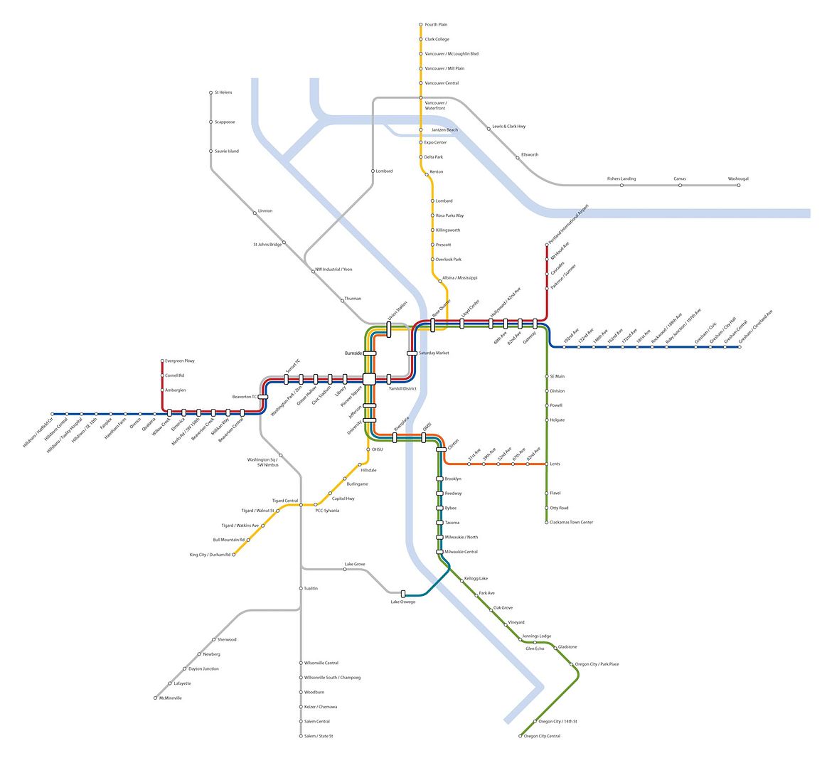
- I haven’t drawn a city center map yet.

- The lines I basically just made up are the St. Johns Yellow Line branch, the I-5 South to Boones Ferry Orange Line branch, the East Vancouver Red Line branch (I did see a map from the 80s that listed this as a possibility, but haven’t seen anything in current documents about it), the Bethany Red Line branch, the Blue Line Express, and the TV highway commuter rail. All the others were mentioned as possibilities for future high capacity transit in the RTP or somewhere else (though I made up the station locations on some of them).
So what do you think? What areas did I leave out that should have rail service? Does anyone else have a “fantasy transit map” for Portland? Feel free to post it if you do.
__________________
Some photo threads I've done... Portland (2021) | New York (2011) | Seattle (2011) | Phoenix (2010) | Los Angeles (2010)
flickr
Reply With Quote
     
     
  #2  
Old Posted Mar 26, 2008, 4:47 AM
MarkDaMan's Avatar
MarkDaMan MarkDaMan is online now
Moderator
 
Join Date: May 2005
Location: Portland
Posts: 7,516
I think it looks great!

I know what people think about the 'couver. I like to give those fuckers a hard time too, but, they (or possibly TriMet) have an extensive line planned running it up I-5 across SR-500 and back down the 205 to the Red Line.

That could spawn new lines up there too.

I'd also thow in a line to Damasucks, maybe on your Grey line...

Thanks! Great visual.
__________________
make paradise, tear up a parking lot
Reply With Quote
     
     
  #3  
Old Posted Mar 26, 2008, 5:19 AM
bvpcvm bvpcvm is offline
Registered User
 
Join Date: Apr 2004
Location: Portland
Posts: 2,788
nice job! of course, trimet would probably add twice as many stations, just to make sure the trains didn't run too fast (rolling eyes).

i did see a metro document about 6 months ago that listed all kinds of projects for down the road (i think it might be one of their 2035 transportation plan documents - or something to do with JPACT) and one of them was an extension of the red line up to amberglen.

oh and one other project you could add - commuter rail to scappoose and st helens. if you're feeling ambitious.
Reply With Quote
     
     
  #4  
Old Posted Mar 26, 2008, 5:36 AM
rsbear's Avatar
rsbear rsbear is offline
Registered User
 
Join Date: Jan 2007
Location: Texas - Hill Country
Posts: 822
Awesome and very well thought out. Nice job!
Reply With Quote
     
     
  #5  
Old Posted Mar 26, 2008, 6:52 AM
PuyoPiyo's Avatar
PuyoPiyo PuyoPiyo is offline
Puyo!
 
Join Date: Sep 2006
Location: Vancouver, WA
Posts: 627
I like it!
__________________
Colorful Past, Bright Future.
My Diagram =====>> http://skyscraperpage.com/diagrams/?m21438
Reply With Quote
     
     
  #6  
Old Posted Mar 26, 2008, 7:03 AM
joeplayer1989 joeplayer1989 is offline
Registered User
 
Join Date: Oct 2007
Posts: 141
omg that Tanasbourne Bethany extension came to me in a dream!!! i love it!!!!!!!
Reply With Quote
     
     
  #7  
Old Posted Mar 26, 2008, 1:48 PM
IHEARTPDX IHEARTPDX is offline
Closed account
 
Join Date: Jul 2005
Posts: 105
Wow that's gorgeous and well thought out!
Although I would love to see 2 more extensions: Newberg to McMinnville, and something to Scapoose/St. Helens perhaps?
What are your ideas for subway lines downtown/eastside? I'd love to see those too.
Reply With Quote
     
     
  #8  
Old Posted Mar 26, 2008, 2:26 PM
WonderlandPark's Avatar
WonderlandPark WonderlandPark is offline
Pacific Wonderland
 
Join Date: Mar 2006
Location: Bi-Situational, Portland & L.A.
Posts: 4,129
Hope the downtown inset map shows some underground MAX lines, very important, IMO

nice map
__________________
"The large print giveth and the small print taketh away"

travel, architecture & photos of the textured world at http://www.pixelmap.com
Reply With Quote
     
     
  #9  
Old Posted Mar 26, 2008, 2:27 PM
Sekkle's Avatar
Sekkle Sekkle is offline
zzzzzzzz
 
Join Date: Aug 2006
Location: Portland area
Posts: 2,276
Thanks, guys. I'll add commuter rail to St. Helens, extend the Newberg one to McMinville and expand the Vancouver ones a little.

Quote:
What are your ideas for subway lines downtown/eastside?
I have wondered about something like that... I think it's a long, long time off, but it would be great to see. I was thinking that, maybe by removing a couple MAX stops downtown and shifting one or two, they could fit three-car trains, at least on the Blue/Red lines and increase capacity a bit. My thought was - move the Oak/1st stop to beneath the Morrison Bridge overpass, get rid of the Morrison/3rd, Yamhill and Old Town stops. But that still leaves the Mall, Pioneer Courthouse Square and Galleria stops, two of which are pretty important for transfers... maybe that part could be grade separated somehow.
__________________
Some photo threads I've done... Portland (2021) | New York (2011) | Seattle (2011) | Phoenix (2010) | Los Angeles (2010)
flickr
Reply With Quote
     
     
  #10  
Old Posted Mar 26, 2008, 2:49 PM
rsbear's Avatar
rsbear rsbear is offline
Registered User
 
Join Date: Jan 2007
Location: Texas - Hill Country
Posts: 822
Quote:
Originally Posted by ForAteOh View Post
Thanks, guys. I'll add commuter rail to St. Helens, extend the Newberg one to McMinville and expand the Vancouver ones a little.


I have wondered about something like that... I think it's a long, long time off, but it would be great to see. I was thinking that, maybe by removing a couple MAX stops downtown and shifting one or two, they could fit three-car trains, at least on the Blue/Red lines and increase capacity a bit. My thought was - move the Oak/1st stop to beneath the Morrison Bridge overpass, get rid of the Morrison/3rd, Yamhill and Old Town stops. But that still leaves the Mall, Pioneer Courthouse Square and Galleria stops, two of which are pretty important for transfers... maybe that part could be grade separated somehow.
Here are some ideas you could incorporate into your downtown insert map:

A subway running the entire length of downtown along 5th and 6th provide MAX service downtown, and greatly increase through-traffic spead:

Trains coming in along the Banfield would enter a subway immediately upon exiting the freeway. Those trains would be underground along Holiday, under the river, and then along fifth and sixth. Trains coming in from Sunset TC would enter a tunnel just east of the Goose Hollow stop and join up with the 5th/6th avenue subways around Columbia. Tricky engineering on that one, but I'm planning here. Trains to Milwaukie would go underground at Front and Lincoln and stay underground west to the 5th/6th subway. Trains coming along Barbur would either have to leap the 405 and then dive to join the subway or would have to dive deep before the 405 and then come up a bit to meet the 5th/6th subway.

The existing MAX tracks from Goose Hollow to Lloyd Center becomes a Streetcar loop. The surface tracks now being placed on 5th and 6th would also become Streetcar surface.
Reply With Quote
     
     
  #11  
Old Posted Mar 26, 2008, 5:10 PM
Sekkle's Avatar
Sekkle Sekkle is offline
zzzzzzzz
 
Join Date: Aug 2006
Location: Portland area
Posts: 2,276
Ok, I added a couple commuter lines, and extended some of the other stuff I had shown before. I’ll probably work on the City Center/potential subway stuff another day, since I'm pretty busy at work today. (this map is clickable, too, if you want a bigger version).

__________________
Some photo threads I've done... Portland (2021) | New York (2011) | Seattle (2011) | Phoenix (2010) | Los Angeles (2010)
flickr
Reply With Quote
     
     
  #12  
Old Posted Mar 26, 2008, 8:00 PM
NJD's Avatar
NJD NJD is offline
Registered User
 
Join Date: Aug 2006
Location: Portland
Posts: 632
^ Nice work! I think you have nailed the MAX and commuter rail expansions perfectly in the Portland area.

I just threw together a map of expanded passenger rail service for western Oregon as a complimentary piece. What do you think? The blue is Amtrak Cascades high-speed intercity service, red is local and express services on existing track, and yellow are potential lines that would require some new track.
Reply With Quote
     
     
  #13  
Old Posted Mar 27, 2008, 4:28 AM
PuyoPiyo's Avatar
PuyoPiyo PuyoPiyo is offline
Puyo!
 
Join Date: Sep 2006
Location: Vancouver, WA
Posts: 627
Nice work, ForAtEOh! I would assume this would be the future after Mayor Pollard successfully got light rails reach to Vancouver.

NJD, that would be a big project!
__________________
Colorful Past, Bright Future.
My Diagram =====>> http://skyscraperpage.com/diagrams/?m21438
Reply With Quote
     
     
  #14  
Old Posted Mar 27, 2008, 6:12 AM
portlandexpos04 portlandexpos04 is offline
Registered User
 
Join Date: Oct 2005
Posts: 9
where did you get that base map? Its super clean.
Reply With Quote
     
     
  #15  
Old Posted Mar 27, 2008, 6:37 AM
bvpcvm bvpcvm is offline
Registered User
 
Join Date: Apr 2004
Location: Portland
Posts: 2,788
Quote:
Originally Posted by portlandexpos04 View Post
where did you get that base map? Its super clean.
googlemaps/terrain
Reply With Quote
     
     
  #16  
Old Posted Mar 28, 2008, 3:12 AM
Tim the Enchanter's Avatar
Tim the Enchanter Tim the Enchanter is offline
Registered User
 
Join Date: Dec 2004
Location: PDX
Posts: 119
Nice maps ForAteOh.

What is the CRC btw?
__________________
"Some call me Tim?"
Reply With Quote
     
     
  #17  
Old Posted Mar 28, 2008, 3:35 AM
MarkDaMan's Avatar
MarkDaMan MarkDaMan is online now
Moderator
 
Join Date: May 2005
Location: Portland
Posts: 7,516
Columbia River Crossing...

You know, for the $4B something for the CRC, I think $4B would get close to paying for all those lines, exluding the already in the works Milwaukie, no? And even some prelim subway work!
__________________
make paradise, tear up a parking lot
Reply With Quote
     
     
  #18  
Old Posted Mar 29, 2008, 3:40 AM
NJD's Avatar
NJD NJD is offline
Registered User
 
Join Date: Aug 2006
Location: Portland
Posts: 632
^ yep, but the 'couv nor the feds at this point in our history would allow for such a progressive Mt. Hood Highway-esque reverting funds plan.
Reply With Quote
     
     
  #19  
Old Posted Mar 29, 2008, 3:48 PM
MarkDaMan's Avatar
MarkDaMan MarkDaMan is online now
Moderator
 
Join Date: May 2005
Location: Portland
Posts: 7,516
Hmmmm...It was even more revolutionary then, I think it could be done.

Maybe I need a hobby, and Sam Adams on board!
__________________
make paradise, tear up a parking lot
Reply With Quote
     
     
  #20  
Old Posted Mar 29, 2008, 9:17 PM
bvpcvm bvpcvm is offline
Registered User
 
Join Date: Apr 2004
Location: Portland
Posts: 2,788
Reply With Quote
     
     
This discussion thread continues

Use the page links to the lower-right to go to the next page for additional posts
 
 
Reply

Go Back   SkyscraperPage Forum > Regional Sections > United States > Pacific West > Portland > Transportation & Infrastructure
Forum Jump


Thread Tools
Display Modes

Forum Jump


All times are GMT. The time now is 10:11 PM.

     
SkyscraperPage.com - Archive - Privacy Statement - Top

Powered by vBulletin® Version 3.8.7
Copyright ©2000 - 2024, vBulletin Solutions, Inc.