HomeDiagramsDatabaseMapsForum About
     

Go Back   SkyscraperPage Forum > Regional Sections > United States > Pacific West > Portland > Transportation & Infrastructure


Reply

 
Thread Tools Display Modes
     
     
  #21  
Old Posted Apr 29, 2008, 2:20 PM
bvpcvm bvpcvm is offline
Registered User
 
Join Date: Apr 2004
Location: Portland
Posts: 2,788
http://www.portlandtribune.com/news/...40989590562900

OHSU lobbies for rail route

By Jim Redden
The Portland Tribune, Apr 29, 2008

In an open house today, Oregon Health & Science University is looking for public input on its plans for a satellite campus on 9.3 donated acres in the North Macadam Urban Renewal Area. The design would place the new MAX line along the campus’ southern edge on its way out of downtown.
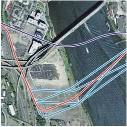
COURTESY OF OHSU


An intense three-month period of public review, comment and decisions on the next MAX line kicks off informally today.
It’s the day Oregon Health & Science University holds an open house on the latest design for its proposed satellite campus in the North Macadam Urban Renewal Area.
The campus will be built on 9.3 acres donated to the teaching university by the Schnitzer family.
Although it’s not officially part of the regional decision-making process on the Portland-to-Milwaukie light-rail line, the design includes the route OHSU wants for the planned bridge across the Willamette River that will carry the line from downtown through its campus.
As depicted in the maps to be displayed at the open house, the route would carry the line along the southern edge of its 19.3-acre campus, where it abuts property held by ZRZ Inc., the barge-building company owned by the Zidell family.
Among planners working on the line, the route is known as the revised Porter-Sherman alignment.
It would follow a new Southwest Porter Street on the campus before crossing the river over the bridge and landing on Southeast Sherman Street between the Oregon Museum of Science and Industry and the Portland Opera headquarters.
OHSU does not have the authority to set the alignment, however.
That will be determined over the next three months by the governments and agencies that are partnering on the project — the cities of Portland and Milwaukie, TriMet, and Metro, the regional government charged with managing growth in most of the tri-county region.
The goal is to submit a detailed plan for the line to the federal government on Aug. 1 so that it can be included for funding in the Omnibus Transportation Spending bill that Congress is expected to pass next year.
The total cost is estimated at between $1.25 billion and $1.4 billion, with the federal government expected to contribute $750 million.
The state of Oregon has committed $250 million in lottery-backed bond funds, with the local governments expected to pay the balance.
Major steps toward these decisions are scheduled to begin shortly after today’s open house.
An advisory committee chaired by former Portland Mayor Vera Katz is scheduled to meet May 1 to recommend a route for the bridge.
Called the Willamette River Partnership Committee, it comprises property owners on both sides of the river, including the owners of the Portland Spirit tour boat, which docks along the east bank of the river near where the bridge could touch down.
David Knowles, a consultant working on the project, said the Porter-Sherman alignment is receiving serious consideration.
Within two weeks of the group’s making its recommendation, Metro is scheduled to release a Draft Environmental Impact Statement for the entire Portland-to-Milwaukie route. It will analyze a number of alternatives that have been under discussion and is intended to help the participating governments make their decisions.
Public comment will be taken for 45 days after the release of the environmental impact statement.
Big decisions are on horizon

Metro is tentatively scheduled to hold open houses on the line May 15 and May 27, with times and locations to be announced.
A Citizens Advisory Committee helping Metro will make its recommendations before the end of the public comment period.
Some of the biggest decisions will then be made by a steering committee consisting of elected officials from the jurisdictions along the line.
They will choose the exact route, including the alignment of the river bridge and the location of the station stops.
Those recommendations will go to Metro for approval before being submitted to the federal government. The elected Metro Council is scheduled to adopt what is called the locally preferred alternative of the plan July 24.
As it is designing its satellite campus, OHSU is concerned about far more than just the route of the next MAX line.
Because the location is a former brownfield with no real street grid, it’s essentially a blank slate — giving designers a free hand to place the roads and bridges within it.
According to Susan Hartnett, OHSU’s director of transportation who is working on the project, one goal is to create the most environmentally sustainable campus in the country.
Toward that end, the current design calls for streets to be oriented slightly off a true east-west alignment to allow the buildings to take full advantage of the sun’s heating rays.
Campus rises up, literally

Hartnett and other OHSU officials also are working to determine the best land elevations throughout the campus. The site is below the allowable flood line set by the Federal Emergency Management Agency. It will be raised substantially by fill dirt before construction begins.
Depending on the design of the bridge ramp, portions of the new Porter Street could be raised 14 feet over its current elevation. Other parts of the campus will need to be raised at least 4 feet, Hartnett said.
The proposed design includes a 100-foot-wide Willamette Greenway running the length of the campus.
This feature is included in the city’s master plan for the North Macadam area. OHSU is not in a position to determine the exact greenway design, however, because most of that land is owned by ZRZ.
Hartnett cautioned that although a lot of work has gone into the campus design proposal, it is not intended to be the final version. Public feedback from the open house will help shape refinements, Hartnett said.
No schedule has been set yet for construction to begin.

jimredden@portlandtribune.com
Reply With Quote
     
     
  #22  
Old Posted Apr 30, 2008, 9:57 PM
NJD's Avatar
NJD NJD is offline
Registered User
 
Join Date: Aug 2006
Location: Portland
Posts: 632
Milwaukians want Park Avenue extension for light rail
Station location desires downtown vary; many frustrated over process

By Matthew Graham
The Clackamas Review, Apr 30, 2008

If light rail is coming through Milwaukie, residents want it extended to Park Avenue.

That was the sentiment at a meeting Monday night at which residents got to voice their preference for a terminus — either Lake Road downtown or Park Avenue in Oak Grove — and for station placements in Milwaukie. Residents provided input on whether they wanted one or two stations, and where they preferred the stops; at Harrison, Monroe, Washington or Lake.

“The project itself is a regional project and Milwaukie has a voice in that project, but it’s a single voice,” said Kenny Asher, Milwaukie community development director. “But I would say [the Milwaukie site location] is a local choice. In terms of planning them, that’s for this community to decide.”

“It’s city staff that is asking you to help us answer these questions,” Asher said, explaining that the meeting was put on by the city, though Metro and TriMet representatives attended.

Park Avenue preferred

Many community members supported the light rail extension down to Oak Grove for two reasons: they saw a terminus and turnaround as too large and cumbersome for Lake Road at the south end of downtown; and they realized the benefit of catching more potential traffic farther south.

“I think what makes this particular line work is the extension to Park Avenue because you have to catch the traffic before it hits the bottleneck,” said Jeff Klein, chair of both the Lewelling Neighborhood District Association and the Planning Commission.

Linda Hedges, secretary of the Hector-Campbell NDA, said she wants an extension to Park Avenue with a station at Lake Road.

“I think the Lake Road area has the biggest potential for future redevelopment,” she said.

Some didn’t have specific site preferences, but had ideas for the downtown area.

Wallace Bischoff, a 48-year resident of Milwaukie, said having a single station would allow for a more concentrated police presence, and said at least one station is necessary to serve the riverfront area and to develop commercial properties downtown.

While Jerry Foy, of St. John’s church and school, said one station on the north end of downtown, away from the schools, would be best if light rail comes through.

Frustrations over process

Some in attendance, though, expressed frustration over the process, saying they couldn’t make these decisions without data on their impacts, some of which will be included in the Supplemental Draft Environmental Impact Statement to be released May 9, while others said the city’s and Metro’s process was insufficient.

“The way this meeting is set up it will reflect in the record later as people having agreed to one or two of the stations” when they’re fundamentally opposed to light rail, said Beth Wasko.

Some said they felt like children being asked what color sweater they preferred — a question meant more to make them feel like they were making an important and consequential decision, though either way they’d be wearing a sweater they didn't like.

Mike Miller said he needed more information to make such a decision.

“I don’t know how you make a decision on a station when you don’t have the impacts on the neighborhoods, you don’t have the costs to the city,” he said.

And Patty Wisner, chair of the Design and Landmarks Commission, took that sentiment one step further.

“After going to the last station planning meeting I thought this was an exercise in futility without knowing the effects on traffic on our streets,” she said. “I think relying on the SDEIS to placate our concerns is lame at best.”

Wisner said she wants Milwaukie staff to find a neighborhood in Portland with similar characteristics in terms of street size and traffic that now has light rail and to study the traffic backup when a train comes through.

“And then let’s get flaggers out and actually stop traffic for those time intervals in Milwaukie,” Wisner continued. “Let’s stop traffic in Milwaukie before millions and billions are spent, because those people at TriMet and Metro, this project is job security for them … they don’t have to live with it in Milwaukie.”

Asher replied that finding out those things was the whole reason for the SDEIS.

“The EIS process, the reason we keep talking about it, all the questions you guys are asking, everything under the sun, are the reason” it’s required, he said. “For me, spending millions of dollars and a year-and-a-half with an army of [engineers and consultants], that’s what I want as a taxpayer of the region.”
Reply With Quote
     
     
  #23  
Old Posted Apr 30, 2008, 10:03 PM
NJD's Avatar
NJD NJD is offline
Registered User
 
Join Date: Aug 2006
Location: Portland
Posts: 632
Span Spin
Diagnosis for a new bridge alignment: OHSU benefits.

BY NIGEL JAQUISS | njaquiss at wweek dot com

Former Mayor Vera Katz will double down this week on a big bet she made years ago that OHSU’s dreams would power Portland’s future.

Katz—who is chairing a committee that includes representatives from TriMet, Metro and the City of Portland—is scheduled Thursday, May 1, to announce the preferred alignment for a new bridge over the Willamette River that would finally extend light rail from downtown to Milwaukie.

Such a light-rail extension has been planned for more than a decade. But after months of study, Katz’s committee—staffed by her former planning director, David Knowles, now a private consultant—has decided to recommend shifting it south, close to Oregon Health & Science University’s South Waterfront campus.

The 6.5-mile extension to Milwaukie inched closer to reality last year, when the Legislature committed $250 million in lottery-backed bonds to what TriMet spokeswoman Mary Fetsch says is a project price tag of $1.25 billion to $1.4 billion.

A battle among South Waterfront property owners during Katz’s tenure over where light rail would cross the Willamette ended in 2003 with a “locally preferred alternative” that crossed the river at Southwest Harrison Street near Riverplace. That line would run in a straight line across the Willamette to OMSI.

A lot has changed since then, however. The city has invested hundreds of millions of dollars in infrastructure in South Waterfront, including extending the Portland Streetcar and building the tram to OHSU, two projects that were initiated when Katz was mayor.

Now OHSU wants the light-rail bridge shifted to the south of its planned “Schnitzer Campus.” A stop there would serve its 1,000 employees in the current South Waterfront building and another 11,000 employees on Marquam Hill.

OHSU, which recorded 672,000 patients visits last year, is the city’s biggest generator of traffic, OHSU real estate director Mark Williams says.

“We’re trying to carry on the mission of providing health care and medical education to the public,” Williams says. “As part of that public mission, we want to get people out of cars and a different [light-rail] alignment will help us do that.”

As with any public project, two central questions are who pays and who benefits. Like the tram, such a shift in the light-rail extension will provide a big benefit to OHSU, the city’s largest employer. And like the tram, much of the added cost will probably be borne by adjacent businesses—and depending on the ultimate price tag and discipline to the project’s budget, possibly taxpayers.

Katz calls any comparison to the tram incorrect. “This bridge will benefit the whole region,” she says. “It will help OHSU as well, but it’s about time we stepped up to help the city’s largest employer.” Tom Miller, chief of staff to City Commissioner Sam Adams, who directs the Office of Transportation, says local businesses should pick up the incremental cost of extending the project to accommodate OHSU’s vision for South Waterfront.

One of those businesses, Zidell Marine, which builds barges just south of the Ross Island bridge, has argued for sticking close to the 2003 alignment.

Doing so, says company representative Bob Durgan, would maximize the amount of developable land in South Waterfront and be cheaper.

TriMet project manager Dave Unsworth says shifting the alignment south will add $34 million, but significantly boost ridership by linking to the tram and South Waterfront. He adds that the 2003 alignment would have created disastrous traffic and required costly elevation.

“The extra cost could end up being a wash, and we get more ridership and less traffic,” he says.
Reply With Quote
     
     
  #24  
Old Posted Apr 30, 2008, 10:17 PM
NJD's Avatar
NJD NJD is offline
Registered User
 
Join Date: Aug 2006
Location: Portland
Posts: 632
don't want the Lincoln stop? want a stop near Reed? prefer an extension southward?

Comment period has begun for Milwaukie MAX:
send comments, questions and concerns to: trans@metro.dst.or.us
info at: www.metro-region.org/southcorridor
Reply With Quote
     
     
  #25  
Old Posted May 1, 2008, 12:16 AM
bvpcvm bvpcvm is offline
Registered User
 
Join Date: Apr 2004
Location: Portland
Posts: 2,788
what i don't like about this is that the nearest station is still almost 1/4 mile from the tram, so it'll almost get you there - but not quite. of course, going all the way down to the tram would really complicate crossing the river, so i guess there's no actual good solution.
Reply With Quote
     
     
  #26  
Old Posted May 1, 2008, 6:16 AM
zilfondel zilfondel is offline
Submarine de Nucléar
 
Join Date: Mar 2006
Location: Missouri
Posts: 4,477
I still don't see why this corridor will cost around $150 million/mile (excluding the cost of a what - $400 million bridge?).

thats double the cost of every other previous MAX extension...


I dunno tho, the Bybee station will be pretty close to Reed College. Maybe a 1/4 mile walk.
Reply With Quote
     
     
  #27  
Old Posted May 1, 2008, 5:52 PM
urbanlife's Avatar
urbanlife urbanlife is offline
A before E
 
Join Date: Aug 2001
Location: Milwaukie, Oregon
Posts: 11,782
Quote:
Originally Posted by zilfondel View Post
I still don't see why this corridor will cost around $150 million/mile (excluding the cost of a what - $400 million bridge?).

thats double the cost of every other previous MAX extension...


I dunno tho, the Bybee station will be pretty close to Reed College. Maybe a 1/4 mile walk.
I am guessing it has something to do with the elevation change. The streetcar had alot to deal with to get down to the water.
Reply With Quote
     
     
  #28  
Old Posted May 1, 2008, 6:46 PM
NJD's Avatar
NJD NJD is offline
Registered User
 
Join Date: Aug 2006
Location: Portland
Posts: 632
^ Trimet and Metro have yet to release the details of the alignment, only lines on maps and aerial photographs. My guess is a lot of aerial guideway to and from the new bridge, grade cuts separating railroad and major street interchanges, the land and building acquisitions along most of this route (versus in street ROW and Freeway shoulders as we have seen on previous projects), mitigation and safety measures for the nearby residents, and mostly the crazy construction boom worldwide causing material prices to skyrocket all contribute to the overall cost.
Reply With Quote
     
     
  #29  
Old Posted May 2, 2008, 3:36 PM
MarkDaMan's Avatar
MarkDaMan MarkDaMan is offline
Moderator
 
Join Date: May 2005
Location: Portland
Posts: 7,517
WoW, this thing is picking up steam!

Panel realigns route of Portland to Milwaukie light-rail span
The proposed Willamette River crossing would link the South Waterfront to an area south of OMSI
Friday, May 02, 2008
ERIC MORTENSON
The Oregonian

A new bridge to carry light-rail trains, streetcars, bicyclists and pedestrians over the Willamette River should be built on an alignment that connects one of Portland's biggest tourist draws to its biggest employer, a committee of property owners, business leaders and government officials agreed Thursday.

The Willamette River Crossing Partnership, chaired by former Mayor Vera Katz, recommended what it called a "most supported" alignment. The crossing, part of the new $1 billion-plus Portland to Milwaukie light-rail line, would jump the river just south of Oregon Museum of Science and Industry on the east side and land on the west side between Southwest Meade and Sherman streets.

The western landing would provide access to Oregon Health & Science University's South Waterfront property and to the aerial tram that ascends to the medical school's facilities on the hill.

The alignment puts the new bridge between the Marquam Bridge to the north and the Ross Island Bridge to the south. The recommendation goes to the Project Steering Committee, made up of elected officials.

Final alignment approval is expected this summer, after which bridge design and engineering work would begin in earnest. Construction is tentatively scheduled for 2011-14. The bridge would go into service in 2015.

Many details must be sorted out before then.

Mariners are concerned that the bridge be high enough -- 75 feet above the water line is the working assumption -- to allow river traffic. They also say the channel in which they pass under the bridge should be aligned with other bridges, so boats and long barges in particular don't have to swerve back and forth to make passage.

Also at issue are the landings on either end, the location of pilings and the slope of the bridge.

The cost of the overall project, including the bridge, is estimated at $1.25 billion to $1.4 billion. Of that, $1 billion is known to be available. The federal government will provide up to $750 million, and the Oregon Legislature has allocated $250 million in state lottery bond money.

That leaves a local match of $250 million to $400 million, and Metro may provide $72 million toward that figure, said Richard Brandman, the regional government's deputy planning director.

The light-rail extension, nearly seven miles long, is a joint project of the cities of Portland, Milwaukie and Oregon City, Clackamas and Multnomah counties, TriMet, Metro and the Oregon Department of Transportation.

Previous proposed alignments for the bridge included one that would have swooped under the Marquam Bridge. That's been discarded in favor of an alignment that links what planners say could be Portland's science and technology quarter, in addition to providing mass transit to the fast-growing suburbs southeast of the city.
http://www.oregonlive.com/news/orego...700.xml&coll=7
__________________
make paradise, tear up a parking lot
Reply With Quote
     
     
  #30  
Old Posted May 2, 2008, 10:51 PM
zilfondel zilfondel is offline
Submarine de Nucléar
 
Join Date: Mar 2006
Location: Missouri
Posts: 4,477
hopefully we'll be able to walk/bike across the river at that point, too. That would be awesome.
Reply With Quote
     
     
  #31  
Old Posted May 6, 2008, 2:53 PM
CouvScott CouvScott is offline
Registered User
 
Join Date: Sep 2005
Location: Washougal, WA
Posts: 1,107
Six options are now on table for the South Corridor bridge

Newest alignment would connect Oregon Health and Science University, OMSI with bridge across Willamette River
POSTED: 06:00 AM PDT Monday, May 5, 2008
BY TYLER GRAF

As Metro prepares to release the draft environmental impact statement for the South Corridor Portland-Milwaukie Light Rail Project, the River Partnership Committee, composed of residents and business leaders and headed by former Mayor Vera Katz, has presented its own option for the location of a bridge across the Willamette River.

The committee is recommending a bridge that would connect Oregon Health and Science University to the Oregon Museum of Science and Industry, as a way of bridging the science and technology corridor that spans the river. Like the other alternatives presented in the environmental statement, the committee’s recommended option would carry cars, bikes, pedestrians and light rail, but it would do so from a westside landing between Mead and Porter streets.

“It’s very realistic that this (newer option) could be the option used down the road,” said Karen Kane, senior public policy coordinator for Metro.

The impact statement, set for release this week, examines the current site locations for the multi-modal bridge along the South Corridor.

The committee’s recommendation, however, is not addressed in the environmental statement. The proposals included date back to 2003, when Metro Council identified its original option, consisting of 6.4 miles of light rail, 11 stations and the new bridge across the Willamette River just south of the Marquam Bridge.

Four other alternative options identified in the environmental statement all would place the eventual bridge farther south than the 2003 option, and at a greater cost. The location of the option proposed by the River Partnership Committee, with its OHSU-to-OMSI connection, would fall in the middle of the said bridge proposals already studied in the environmental statement.

Portland city planner Steve Iwata says “hybrid options”, such as the new proposal, can emerge as long as their effects are eventually studied.

“This should make the process less complicated,” Iwata said, adding that there has been strong involvement from business leaders and residents.

The new proposal will likely be studied in the final environmental impact statement, Kane, of Metro, saids.

However, the light-rail project would require the acquisition of between 55 and 62 properties, including between two to four residences. Several of the neighborhoods through which the new light rail would travel are home to a significant number of minority and low-income residents, though Metro maintains in the environmental study that no “disproportionately adverse effects are anticipated.”

And although the new proposals are more expensive, they still fit into the budgetary parameters set out by the environmental statement, according to Iwata. It would also fulfill OHSU’s transportation and environmental goals, Metro said.

According to the statement, between 22,000 and 25,000 daily light-rail trips would be expected along the Portland-Milwaukie corridor by the year 2030, depending on the option chosen.

Public comment on the impact statement begins May 9 and lasts for 45 days. During the middle of that period, a citizen advisory council will be making its recommendations. At the end of the period, project management will make its recommendations.
__________________
A mind that is expanded by a new idea can never return to it's original dimensions.
Reply With Quote
     
     
  #32  
Old Posted May 6, 2008, 5:27 PM
urbanlife's Avatar
urbanlife urbanlife is offline
A before E
 
Join Date: Aug 2001
Location: Milwaukie, Oregon
Posts: 11,782
Quote:
Originally Posted by zilfondel View Post
hopefully we'll be able to walk/bike across the river at that point, too. That would be awesome.
I think the bridge would be a waste if that wasnt included into it.
Reply With Quote
     
     
  #33  
Old Posted May 6, 2008, 6:49 PM
alexjon's Avatar
alexjon alexjon is offline
Bears of antiquity
 
Join Date: Dec 2005
Location: Downtown/First Hill, Seattle, WA
Posts: 8,340
I thought that was the plan from the get-go?

I'd be pretty mad if it didn't happen, especially since walking across the Ross Island Bridge is nothing short of frightening.
__________________
"The United States is in no way founded upon the Christian religion." -- George Washington & John Adams in a diplomatic message to Malta
Reply With Quote
     
     
  #34  
Old Posted May 6, 2008, 7:25 PM
tworivers's Avatar
tworivers tworivers is offline
Registered User
 
Join Date: Feb 2006
Location: Portland/Cascadia
Posts: 2,598
Quote:
Comment period has begun for Milwaukie MAX:
send comments, questions and concerns to: trans@metro.dst.or.us
info at: www.metro-region.org/southcorridor
I'm not seeing anything on that webpage about a comment period being underway -- just that there will be one this summer.
Reply With Quote
     
     
  #35  
Old Posted May 6, 2008, 9:21 PM
Sekkle's Avatar
Sekkle Sekkle is offline
zzzzzzzz
 
Join Date: Aug 2006
Location: Portland area
Posts: 2,276
^ It is underway (well, starting May 9th anyway). Go here for info. The supplemental draft EIS has been posted.
__________________
Some photo threads I've done... Portland (2021) | New York (2011) | Seattle (2011) | Phoenix (2010) | Los Angeles (2010)
flickr

Last edited by Sekkle; May 6, 2008 at 9:40 PM.
Reply With Quote
     
     
  #36  
Old Posted May 6, 2008, 9:57 PM
tworivers's Avatar
tworivers tworivers is offline
Registered User
 
Join Date: Feb 2006
Location: Portland/Cascadia
Posts: 2,598
My bad -- thanks.
Reply With Quote
     
     
  #37  
Old Posted May 7, 2008, 1:03 AM
NJD's Avatar
NJD NJD is offline
Registered User
 
Join Date: Aug 2006
Location: Portland
Posts: 632
In response to an email inquiry about the bridge design, a public affairs coordinator from Metro responded:
Quote:
the bridge will not have auto lanes but is designed to have a pedestrian and bicycle path. Also, the more southern bridge alignments are currently the ones we're hearing the most favorable comments about.
Reply With Quote
     
     
  #38  
Old Posted May 8, 2008, 8:05 PM
NJD's Avatar
NJD NJD is offline
Registered User
 
Join Date: Aug 2006
Location: Portland
Posts: 632
Renderings from the SDEIS (Metro)


Note: these renderings are at 5% design and will more than likely change. Also, notice that buses will travel over the new bridge and on the viaduct to Lincoln Street. The last picture eludes to Trimet running the CRC light rail and not C-Tran.

Last edited by NJD; May 8, 2008 at 8:24 PM.
Reply With Quote
     
     
  #39  
Old Posted May 9, 2008, 1:58 AM
OutrageousJ OutrageousJ is offline
Registered User
 
Join Date: Jul 2006
Posts: 23
Great pictures - are there more available online somewhere?

I really hope Tri-met does the project correctly, and makes the alignment as fast as possible (fewer stations, more grade separated, etc.)
Reply With Quote
     
     
  #40  
Old Posted May 9, 2008, 2:31 AM
MarkDaMan's Avatar
MarkDaMan MarkDaMan is offline
Moderator
 
Join Date: May 2005
Location: Portland
Posts: 7,517
please not the concrete segmented bridge...that is so much the Portland way though.
__________________
make paradise, tear up a parking lot
Reply With Quote
     
     
This discussion thread continues

Use the page links to the lower-right to go to the next page for additional posts
 
 
Reply

Go Back   SkyscraperPage Forum > Regional Sections > United States > Pacific West > Portland > Transportation & Infrastructure
Forum Jump


Forum Jump


All times are GMT. The time now is 1:41 AM.

     
SkyscraperPage.com - Archive - Privacy Statement - Top

Powered by vBulletin® Version 3.8.7
Copyright ©2000 - 2024, vBulletin Solutions, Inc.