HomeDiagramsDatabaseMapsForum About
     

Go Back   SkyscraperPage Forum > Photography Forums > Found City Photos

Reply

 
Thread Tools Display Modes
     
     
  #35641  
Old Posted Jun 24, 2016, 3:10 AM
HenryHuntington HenryHuntington is offline
Registered User
 
Join Date: Apr 2013
Location: The OC
Posts: 279
Quote:
Originally Posted by ethereal_reality View Post
I really like the stylized musicians and dancers in the 'Funky Wall', but that wall with the scrawny philodendrons is pretty lame.
_


'mystery' location.


I searched 'Rosemayne' and 'Primrose' using the search function and came up with zero results

so there's a good chance this is new to NLA.


eBay


Any idea where this photograph was taken? (the blade sign appears to say O.L.S Market)


the photo appeared on the cover of this booklette.


eBay
_


Thanks for figuring out the location (Watts Car House at 103rd) in the eBay slide with the red car & orange pickup truck Wig-Wag. -It's much appreciated.
PE 1007 is westbound (inbound) on W. Main St. at Fremont Ave. in Alhambra.
Reply With Quote
     
     
  #35642  
Old Posted Jun 24, 2016, 3:32 PM
MichaelRyerson's Avatar
MichaelRyerson MichaelRyerson is offline
Registered User
 
Join Date: Feb 2011
Location: Houston, Texas
Posts: 1,155
Quote:
Originally Posted by ethereal_reality View Post
Originally posted by Tourmaline


So where do you suppose this photograph of the Syncopation Special was taken? They look like they're out in the middle of the country!

_

The tall blond guy looks like Richard Denning.
Reply With Quote
     
     
  #35643  
Old Posted Jun 24, 2016, 4:02 PM
Blaster's Avatar
Blaster Blaster is offline
Registered User
 
Join Date: May 2013
Location: Los Angeles
Posts: 227
Quote:
Originally Posted by ProphetM View Post
Since you mentioned it:


Chimes tower photo by me, 2013


Not the greatest photos, but they were taken from the tour bus.
Prophet, thanks for the shots. I stayed at the Zane Grey Pueblo a few years ago and enjoyed it.

There are two stories as to why Mrs. Wrigley built the chime tower to annoy Zane Grey. Probably both are apocryphal. One story is that Grey liked to stay up late and throw loud parties. The other is that Grey was a founder of the Tuna Club of Avalon which, in those days, was an all male club that didn't allow women. (The Tuna Club, as we all know, is thinly disguised as the Albacore Club in CHINATOWN.)
Reply With Quote
     
     
  #35644  
Old Posted Jun 24, 2016, 4:07 PM
HossC's Avatar
HossC HossC is offline
Registered User
 
Join Date: Aug 2013
Posts: 4,245
Quote:
Originally Posted by ethereal_reality View Post

'mystery' location.

I searched 'Rosemayne' and 'Primrose' using the search function and came up with zero results

so there's a good chance this is new to NLA.


eBay

Any idea where this photograph was taken? (the blade sign appears to say O.L.S Market)
Quote:
Originally Posted by HenryHuntington View Post

PE 1007 is westbound (inbound) on W. Main St. at Fremont Ave. in Alhambra.
I took the Googlemobile to Main Street at Fremont Avenue, but couldn't see the building on the left. Then I spotted Primrose Avenue a block east, and wondered whether that was the location of the Primrose Apartments. Voilà - there it is. It looks like the end wall has had many names painted on it, but I couldn't make out either the Rosemayne Apartments or the Primrose Apartments.


GSV

The first two windows facing Main Street have been filled in over the years, as have several along Primrose Avenue.


GSV
Reply With Quote
     
     
  #35645  
Old Posted Jun 24, 2016, 4:18 PM
ethereal_reality's Avatar
ethereal_reality ethereal_reality is offline
Registered User
 
Join Date: Feb 2008
Location: Lafayette/West Lafayette IN, Purdue U.
Posts: 16,350
Excellent sleuthing Hoss!

I didn't expect the building to still be standing...what a pleasant surprise to start the day off with.
__

& thanks also to HH, for letting us know the 'mystery' pic was in Alhambra in the first place.
Reply With Quote
     
     
  #35646  
Old Posted Jun 24, 2016, 4:37 PM
ethereal_reality's Avatar
ethereal_reality ethereal_reality is offline
Registered User
 
Join Date: Feb 2008
Location: Lafayette/West Lafayette IN, Purdue U.
Posts: 16,350
Here's another interesting image I found a few minutes ago while looking for some information on Tops Jr. (visible in Hoss's post)

This shows a Pacific Electric streetcar on Huntington Drive in Alhambra between Fremont and Fair Oaks.


https://s-media-cache-ak0.pinimg.com...d8efb254b7.jpg


I haven't been able to find this same vantage point with a current google-street-view.

M & M Foods looks like a nice neighborhood market. (the Thrifty as well)
_
Reply With Quote
     
     
  #35647  
Old Posted Jun 24, 2016, 5:09 PM
HossC's Avatar
HossC HossC is offline
Registered User
 
Join Date: Aug 2013
Posts: 4,245


Here's the intersection in 1948. I think the square white building (arrowed) is the M & M Foods building in the picture above.


Historic Aerials

Due to the trees at the intersection, this is the best "now" view I could get.


GSV

Looking through the images at Historic Aerials, I think the M & M Foods building is still standing, albeit in a slightly altered form. It's now Big Lots.


GSV
Reply With Quote
     
     
  #35648  
Old Posted Jun 24, 2016, 7:20 PM
ethereal_reality's Avatar
ethereal_reality ethereal_reality is offline
Registered User
 
Join Date: Feb 2008
Location: Lafayette/West Lafayette IN, Purdue U.
Posts: 16,350
Thanks Hoss.

So if the current Big Lots is the old B & B Market, that makes this building the old Thrifty's, right?


gsv


detail


Here's a better view, looking from the direction of the Big Lots.


gsv

The building appears to be relatively unchanged from it's time as a Thriftys. -very cool.

__

Last edited by ethereal_reality; Jun 24, 2016 at 7:31 PM.
Reply With Quote
     
     
  #35649  
Old Posted Jun 24, 2016, 7:44 PM
ethereal_reality's Avatar
ethereal_reality ethereal_reality is offline
Registered User
 
Join Date: Feb 2008
Location: Lafayette/West Lafayette IN, Purdue U.
Posts: 16,350
Quote:
Originally Posted by Blaster View Post
The Wrigleys' nearest neighbor was western author Zane Grey. His house is now the Zane Grey Pueblo Hotel. In 1925, Mrs. Wrigley built a chimes tower on the edge of Grey's property to loudly chime the hour every fifteen minutes. The tower was supposed to be a gift to the people of Avalon but the story goes that Mrs. Wrigley actually built it to annoy Grey.


Blaster, here's a postcard from the 1930s or 40s, that shows the close proximity of the chimes tower to Zane Grey's pueblo.


http://islapedia.com/images/0/09/Chimes_Tower_1940s.png


Thanks for sharing your photos of the Wrigley Chimes Tower and Zane Grey Pueblo ProphetM.
It's always fun to see noirisher's personal photographs.

__

Last edited by ethereal_reality; Jun 24, 2016 at 7:59 PM.
Reply With Quote
     
     
  #35650  
Old Posted Jun 24, 2016, 7:57 PM
HossC's Avatar
HossC HossC is offline
Registered User
 
Join Date: Aug 2013
Posts: 4,245
Today's Julius Shulman photo is another mystery location. Just like the Plyform Co picture from a few days, this was also taken for Wailes-Bageman. The CDs list at least three addresses for the Trojan Press around this time - one on De Longpre (1942) and two on Melrose (1956 and 1960). I checked all the addresses with GSV, but none of them match. Does anyone know where it was? This is "Job 115: Trojan Press Lithographing, 1947".


Getty Research Institute
Reply With Quote
     
     
  #35651  
Old Posted Jun 24, 2016, 8:22 PM
Wig-Wag's Avatar
Wig-Wag Wig-Wag is offline
Registered User
 
Join Date: Feb 2012
Posts: 330
[QUOTE=ethereal_reality;7485019]Here's another interesting image I found a few minutes ago while looking for some information on Tops Jr. (visible in Hoss's post)

This shows a Pacific Electric streetcar on Huntington Drive in Alhambra between Fremont and Fair Oaks.


https://s-media-cache-ak0.pinimg.com...d8efb254b7.jpg


I haven't been able to find this same vantage point with a current google-street-view.

In the photo the streetcar is east bound and turning off the PE Northern District Four Tracks on to Fair Oaks Avenue. The triangle created by all the streetcar trackage can bee seen in HossC's Historic Aerial, above. This junction was known as Oneonta Park and can be seen here (sixth photo down on the page):

http://www.pacificelectric.org/categ...trict/page/34/

This view (second photo down on the page) is looking North on Fair Oaks Avenue. At one time there was a station in the center of the wye.

http://www.pacificelectric.org/categ...trict/page/14/

Cheers,
Jack
Reply With Quote
     
     
  #35652  
Old Posted Jun 24, 2016, 8:46 PM
ethereal_reality's Avatar
ethereal_reality ethereal_reality is offline
Registered User
 
Join Date: Feb 2008
Location: Lafayette/West Lafayette IN, Purdue U.
Posts: 16,350
Quote:
Originally Posted by Wig-Wag View Post
This view (second photo down on the page) is looking North on Fair Oaks Avenue. At one time there was a station in the center of the wye.

http://www.pacificelectric.org/categ...trict/page/14/


http://www.pacificelectric.org/wp-co.../AW-PE-wye.jpg

Here's the photo from your link Jack. I don't recall seeing that type of short Wig Wag before.

plus, that amount of concrete in the middle of the street seems to be quite a traffic hazard!

photo info:
"This image captures a Pacific Electric car (in Pasadena Short Line service) heading southbound on Fair Oaks Blvd. in South Pasadena
as it approaches the wye at Huntington Drive and Oneonta Station. The year is believed to be 1951."

__

Last edited by ethereal_reality; Jun 26, 2016 at 12:13 AM.
Reply With Quote
     
     
  #35653  
Old Posted Jun 24, 2016, 8:54 PM
HossC's Avatar
HossC HossC is offline
Registered User
 
Join Date: Aug 2013
Posts: 4,245


Here's the picture from Wig-Wag's first link.

735 at Oneonta Park
Pacific Electric streetcar no. 735 picks up passengers at Oneonta Park in South Pasadena.


www.pacificelectric.org/Jack Finn Collection

Here's an elevated view looking north.

Stacked Up
An amazing collection of Pacific Electric equipment is visible in this 1930s-era shot of South Pasadena's Oneonta Station, where numerous PE lines converged.


www.pacificelectric.org/Jack Finn Collection

I planned to include this image before I saw that e_r had already posted it. I'll post it again because I've done a "now" comparison below.

Looking North on Fair Oaks at Huntington Drive
This image captures a Pacific Electric car (in Pasadena Short Line service) heading southbound on Fair Oaks Blvd. in South Pasadena as it approaches the wye at Huntington Drive and Oneonta Station. The year is believed to be 1951.


www.pacificelectric.org/William W. Wherry/Alan Weeks Collection

This is the view north today.


GSV
Reply With Quote
     
     
  #35654  
Old Posted Jun 24, 2016, 11:22 PM
CityBoyDoug CityBoyDoug is offline
BANNED
 
Join Date: Apr 2013
Posts: 2,868
Quote:
Originally Posted by HossC View Post


I planned to include this image before I saw that e_r had already posted it. I'll post it again because I've done a "now" comparison below.

Looking North on Fair Oaks at Huntington Drive
This image captures a Pacific Electric car (in Pasadena Short Line service) heading southbound on Fair Oaks Blvd. in South Pasadena as it approaches the wye at Huntington Drive and Oneonta Station. The year is believed to be 1951.


www.pacificelectric.org/William W. Wherry/Alan Weeks Collection

This is the view north today.


GSV
Here are two historic aerial views of the intersection. 1948 & 2010...In the 1950-60s I lived about 2 miles east of this view.


historic aerials

Last edited by CityBoyDoug; Jun 25, 2016 at 4:09 AM.
Reply With Quote
     
     
  #35655  
Old Posted Jun 24, 2016, 11:51 PM
ethereal_reality's Avatar
ethereal_reality ethereal_reality is offline
Registered User
 
Join Date: Feb 2008
Location: Lafayette/West Lafayette IN, Purdue U.
Posts: 16,350
I don't remember seeing this before.


http://digital-library.csun.edu/cdm/...n/SFVH/id/4155

The large stone fountain was built in 1890 for animals by The Woman's Christian Temperance Union (WCTU).
Hand written on the photograph: "Early day drinking fountain on Olive Street."

Does anyone recognize the mansion behind it? (the source say this is in Burbank)

It's really unique..kinda' like a little silo. I wonder how many gallons it took to fill it up?

__
Reply With Quote
     
     
  #35656  
Old Posted Jun 25, 2016, 12:31 AM
ethereal_reality's Avatar
ethereal_reality ethereal_reality is offline
Registered User
 
Join Date: Feb 2008
Location: Lafayette/West Lafayette IN, Purdue U.
Posts: 16,350

https://www.etsy.com/listing/1867318...f=sr_gallery_1

"Camera Club Photographers at a Beauty Pageant - Late 1950's Los Angeles Beach Scene"


detail

I'd love to know what these two young boys are thinking.


There's a small portion of a blade sign visible above the beauties' head.


detail


You can see the same hotel blade sign in the black & white photograph below. This is the old St. Marks Hotel on Windward Avenue at Ocean Front, Venice.


The two blade signs on the right (advertising 'liquor' and 'steaks') are also visible in the color photo. (see below)


detail
__

*As most of you know, the St. Marks Hotel building is gone, but the building next to it survives (and is now called St. Mark's today.) -a wee bit confusing.

Last edited by ethereal_reality; Jun 25, 2016 at 1:04 AM.
Reply With Quote
     
     
  #35657  
Old Posted Jun 25, 2016, 3:31 AM
unihikid's Avatar
unihikid unihikid is offline
Registered User
 
Join Date: Dec 2010
Location: South Bay
Posts: 350
Quote:
Originally Posted by CityBoyDoug View Post
Here are two historic aerial views of the intersection. 1948 & 2010...In the 1950-60s I live about 2 miles east of this view.


historic aerials
if you look at both of these topo maps that Doug posted, you can see the old Santa Fe ROW. I always find it funny with as big as SF was/is they tried to compete with PE,who by the 1948 image has a stronger ROW than SF. I think the SF ROW was a single track line, and I know it ran a diesel passenger service (doodlebugs) for a while. One of my close friends lived near the row and we would walk from Main and Morengo (cant thing of the street but that sounds right) to behind where the Rite Aide is off Fair Oaks to see what track remains.. In South Pasadena most of the ROW is gone except near his house,but once you get into Pasadena it turns into the Gold Line IIRC.
Reply With Quote
     
     
  #35658  
Old Posted Jun 25, 2016, 3:35 PM
Ed Workman Ed Workman is offline
Registered User
 
Join Date: Jan 2015
Posts: 145
[QUOTE=HossC;7485343]

Here's the picture from Wig-Wag's first link.


www.pacificelectric.org/Jack Finn Collection

Here's an elevated view looking north.

Stacked Up
An amazing collection of Pacific Electric equipment is visible in this 1930s-era shot of South Pasadena's Oneonta Station, where numerous PE lines converged.


www.pacificelectric.org/Jack Finn Collection

The
'amazing collection' is due to the Rose Parade
PE put on an amazing operation of special trains to Pasadena from all over [ well not exactly ALL] the LA BAsin. On regular days PE ran to the Hill ST Terminal and 6th and Main. But for the Rose PArade specials bypassed the terminals and ran direct. Oneonta was named for a town in New York where Huntingtons had lived. The cupola on the stattion was where the interlocking operator set switches and signals for various movements thru the junction
Reply With Quote
     
     
  #35659  
Old Posted Jun 25, 2016, 4:30 PM
ethereal_reality's Avatar
ethereal_reality ethereal_reality is offline
Registered User
 
Join Date: Feb 2008
Location: Lafayette/West Lafayette IN, Purdue U.
Posts: 16,350
I wondered what was in the cupola.....thanks Ed.


I might have posted this earlier in the thread, but here's a view of the Oneonta Station in 1915.


http://photos.lapl.org/carlweb/jsp/D...=17416&index=z


I'm curious about the white building in Hoss's photograph from the 1930s.


detail

Does it say Red Lion Inn?
__

*Okay, I just realized it says Gilmore's Red Lion.....as in gas station.

It looks like the Gilmore sign is painted on the white building behind the service station (which is mostly hidden by the streetcar)

_

Last edited by ethereal_reality; Jun 25, 2016 at 5:07 PM.
Reply With Quote
     
     
  #35660  
Old Posted Jun 25, 2016, 7:25 PM
HossC's Avatar
HossC HossC is offline
Registered User
 
Join Date: Aug 2013
Posts: 4,245
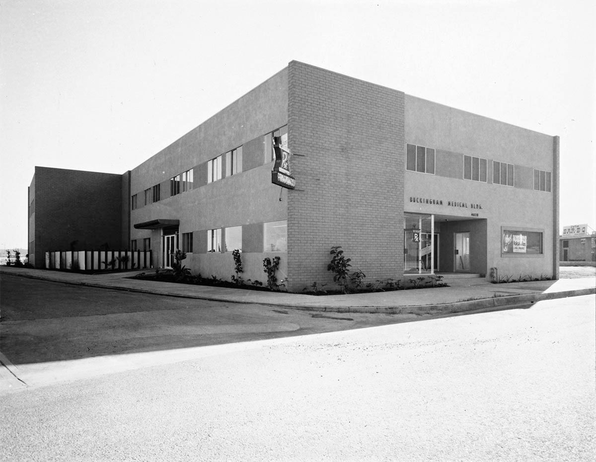
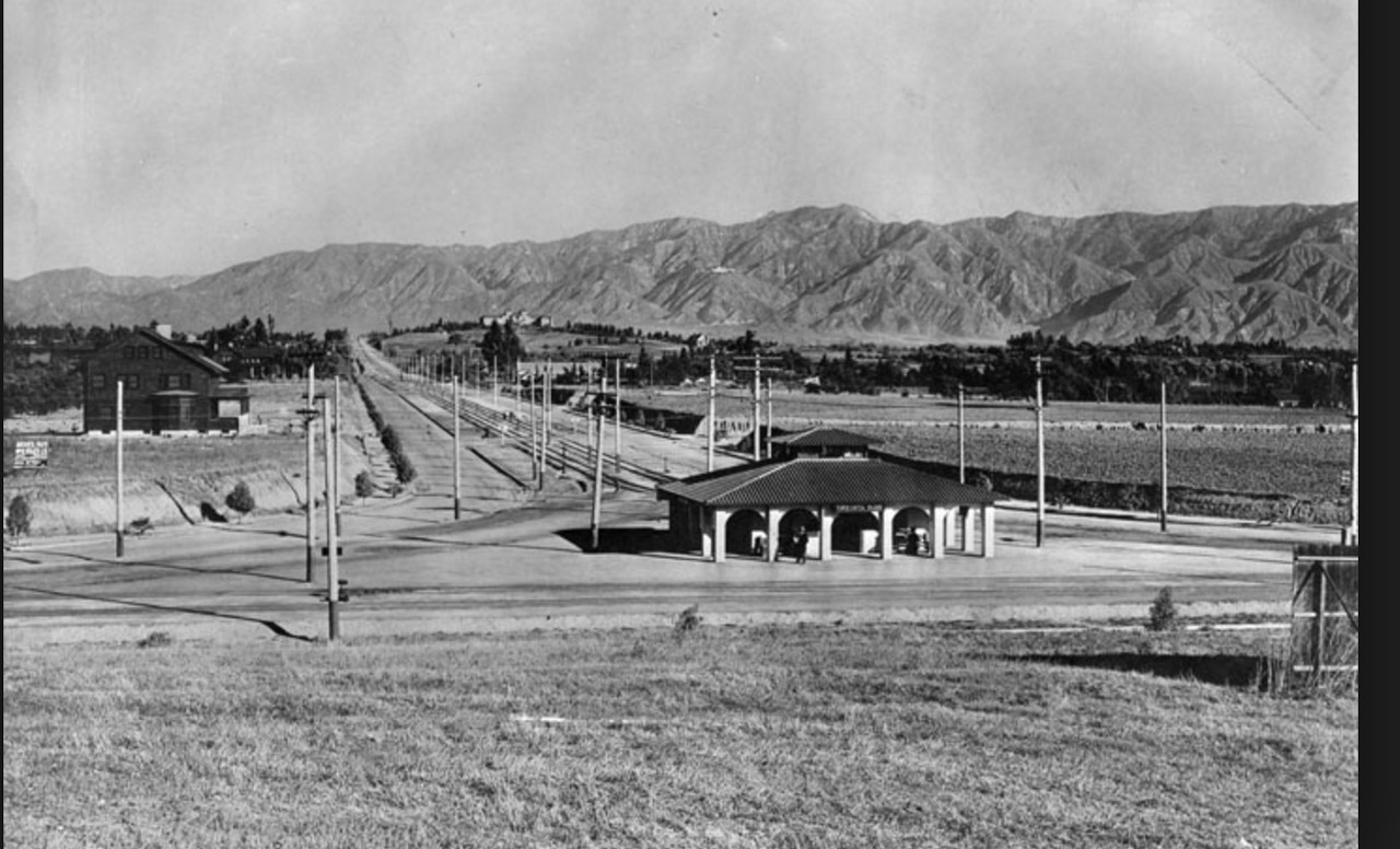
There's no mystery about today's Julius Shulman location. The Buckingham Medical Building was at 4070 Buckingham Road. This is"Job 2126: Buckingham Medical Building, 1956".


Getty Research Institute

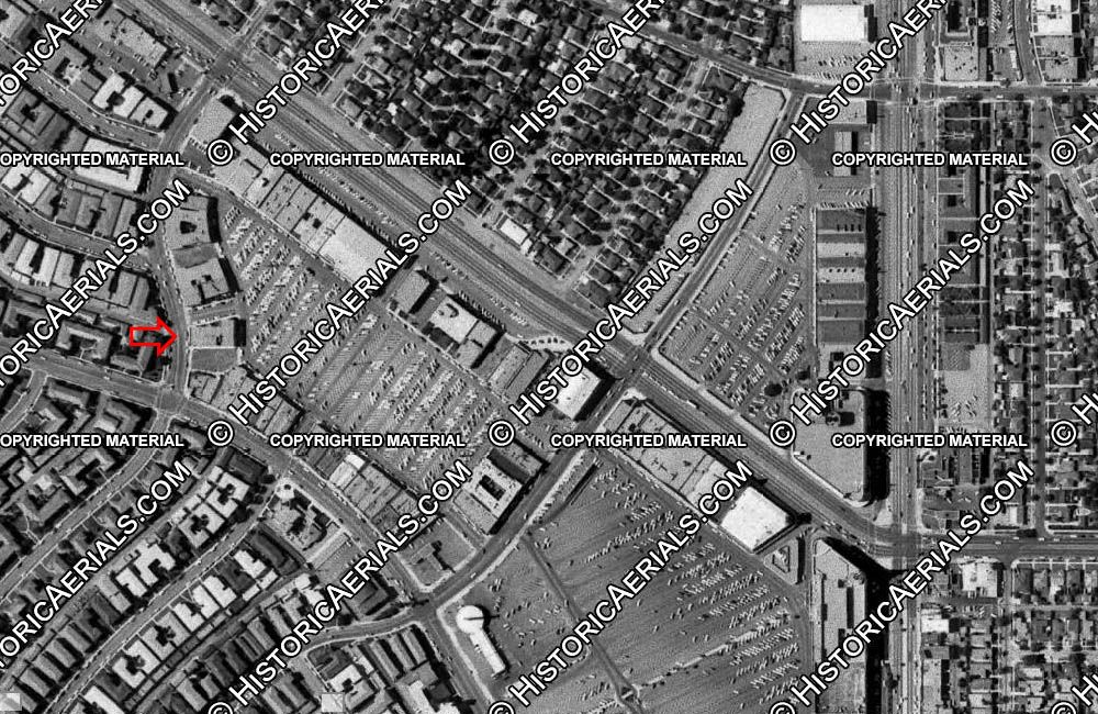
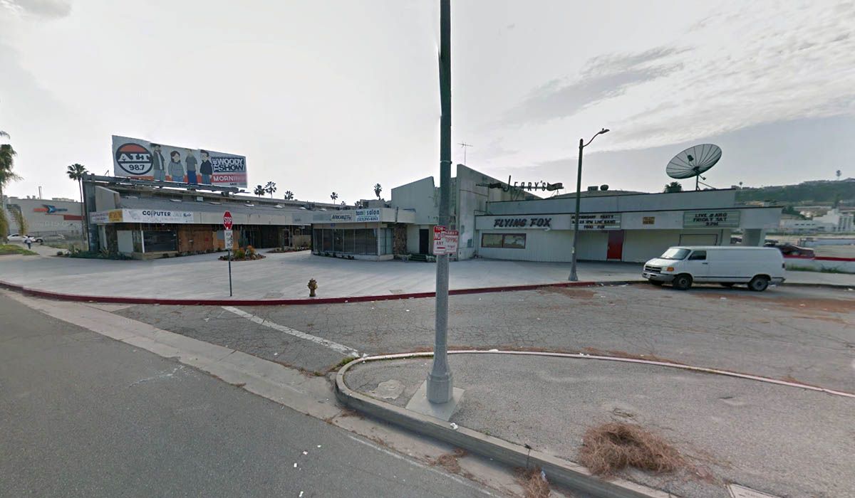
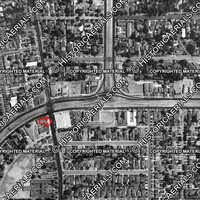
Here's the building on the 1964 aerial view. On the right are the stores at Martin Luther King Jr and Crenshaw Boulevards which we've discussed before.


Historic Aerials

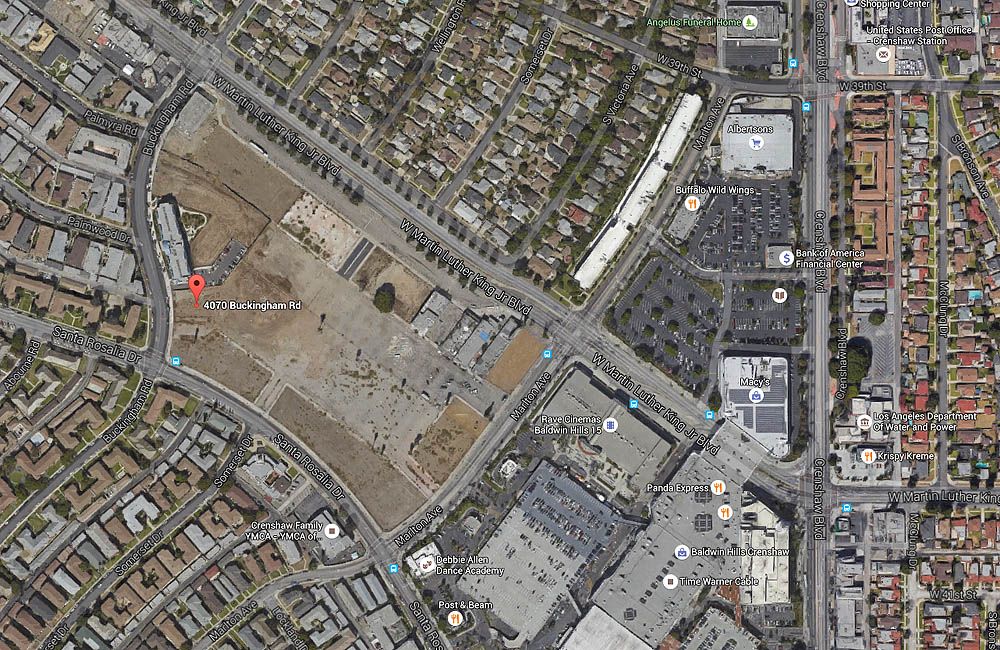
The current view shows how virtually the whole block has been cleared.


Google Maps

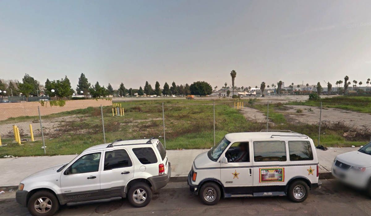
This is all you'll find where the medical building once stood. Checking the historic views, it looks like it was demolished between 1994 and 2003.


GSV

There's a fairly new apartment block near the medical building site, but the only survivors on the block are along Martin Luther King Jr Boulevard. This little mall is near Marlton Avenue. I'm not sure if any of the stores were still in business even on the earliest GSV images. The empty lot on the left was once occupied by Barker Bros, which I posted photos of in post #31806.


GSV

This building is on the corner of Buckingham Road. Apparently, it was once the Founders National Bank. All the buildings in between have now gone, but can still be seen in the old GSV images.
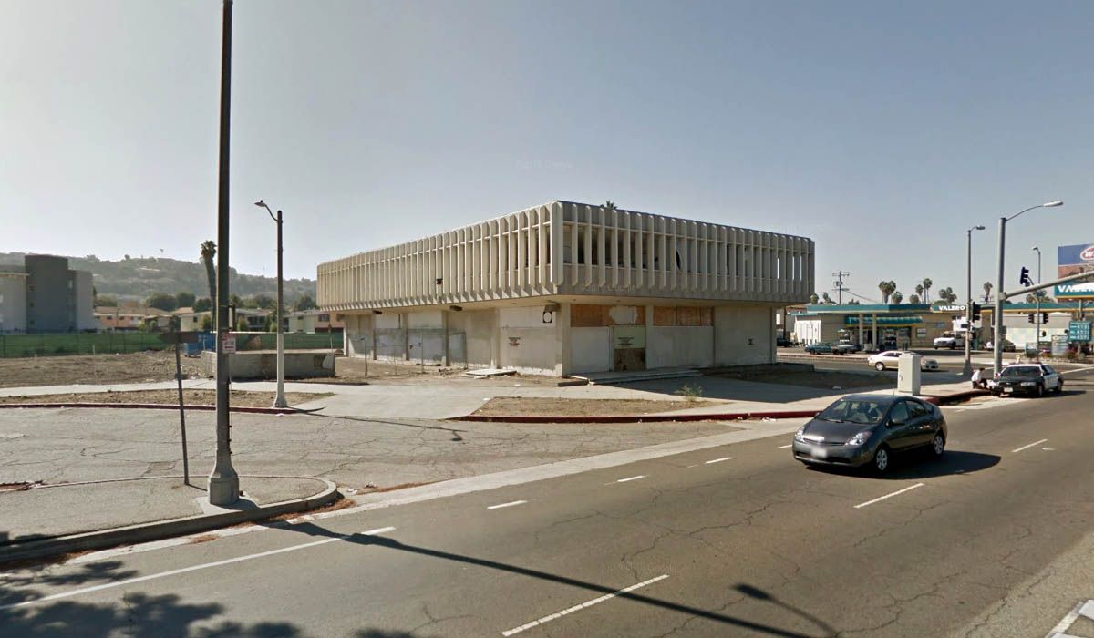

GSV

For a comprehensive look at many of the buildings that once made up Santa Barbara Plaza just before they were demolished, check out an article at architectureburger.com. It's quite long, but there are a lot of pictures and commentary. It seems that the nearly new apartment building that I mentioned above is actually senior housing. When the architectureburger.com article was written in 2011, the project had stalled because the developer had gone bankrupt. They were eventually completed in 2012 - the website is here.

As a side note, the senior housing development is called Buckingham Place, but Google suggested that I meant Buckingham Palace. I believe the latter is currently only home to two nonagenarians .
Reply With Quote
     
     
This discussion thread continues

Use the page links to the lower-right to go to the next page for additional posts

Reply

Go Back   SkyscraperPage Forum > Photography Forums > Found City Photos
Forum Jump


Forum Jump


All times are GMT. The time now is 8:23 AM.

     
SkyscraperPage.com - Archive - Privacy Statement - Top

Powered by vBulletin® Version 3.8.7
Copyright ©2000 - 2024, vBulletin Solutions, Inc.