HomeDiagramsDatabaseMapsForum About
     

Go Back   SkyscraperPage Forum > Regional Sections > Canada > Atlantic Provinces > Halifax > Halifax Photos


Reply

 
Thread Tools Display Modes
     
     
  #621  
Old Posted May 10, 2017, 10:08 PM
OldDartmouthMark OldDartmouthMark is offline
Registered User
 
Join Date: May 2010
Posts: 8,458
Looks like Bicentennial School, which was only a Junior High (7-9) when I was a student, has since been changed to Primary - 9, and would cover this area now.

https://www.google.com/maps/d/viewer...099999999&z=16
Reply With Quote
     
     
  #622  
Old Posted May 16, 2017, 12:44 PM
JET JET is online now
Registered User
 
Join Date: Feb 2007
Posts: 1,813
Old guardhouse at Queens Marque location
http://thechronicleherald.ca/metro/1...-queens-marque
Reply With Quote
     
     
  #623  
Old Posted May 16, 2017, 2:16 PM
OldDartmouthMark OldDartmouthMark is offline
Registered User
 
Join Date: May 2010
Posts: 8,458
Quote:
Originally Posted by JET View Post
Old guardhouse at Queens Marque location
http://thechronicleherald.ca/metro/1...-queens-marque
Very cool! I just added the following to the Queen's Marque thread:


http://thechronicleherald.ca/metro/1...-queens-marque

Quote:
VIDEO: Remnants of old Halifax unearthed at Queen's Marque

The ground below the Queen’s Marque development has proven to be quite the time capsule of centuries-old Halifax.

The project along the Halifax waterfront has unearthed “a complex of buildings” including a guardhouse from the 1780’s, an old fish market and a twine shop.

“(The buildings) add flesh to historical record,” said Bruce Stewart, president of Cultural Resource Management Group, the archaeologists for the project, during an interview Friday.

“We’re looking for a strengthening of our understanding of what life was like for the guards in the guardhouse or people who were using the market.”

The site — along Lower Water Street beside the Maritime Museum of the Atlantic — covers almost five acres at the centre-point of the city, previously known as Queen’s Landing, an area with a rich military, marine and mercantile history.

“We have continued use, re-use, development and redevelopment of this property from 1749 right through until today,” said Stewart.


Bruce Stewart president and Kathryn Stewart, staff archaeologist for Cultural Resource Management group, observe the excavated area of a guard house from the construction site on the Queen’s Marque on Friday, May 12.

When complete, the Queen’s Marque will be mixed-use complex of homes and businesses, along with 75,000 square feet of public space and three new wharves.

Stewart says the discoveries will not jeopardize the 2019 expected completion date.

“We’re working very closely with the contractors and the Armour Group to try and get addressed as quickly as we can,” he said.

“The goal is to minimize any delays.”

The property began use in 1749 as an old British military battery when the first settlers arrived in Halifax. The CRM Group hasn’t found any artifacts from the battery as of yet.

“We’re all keeping a very sharp eye out for that,” said Stewart.

The archaeologists complied old photos, maps and paintings of the area, so what they’ve found thus far hasn’t been much of a surprise.

“One of the biggest surprises for me, is there are fewer artifacts than we expected,” said Stewart.

“It’s a lot cleaner in that sense.”

As far as artifacts go, the archaeologists have found a cannonball, an old boot and broken pottery.

One of the bigger discoveries is of two large granite property markers with the initials “W.D.” engraved on them. Stewart says this stands for “War Department,” which is the British military stamp.

The markers will be incorporated into the final project for public viewing.

“Those are really excellent pieces,” said Stewart. “They’re in beautiful condition.”

The land markers are about two metres tall and similar ones can be found around town, including in Point Pleasant Park
.
The granite property markers he is talking about are explained well in Stephen Archibald's "Noticed In Nova Scotia" blog:

http://halifaxbloggers.ca/noticedinn...ur-boundaries/
Reply With Quote
     
     
  #624  
Old Posted May 16, 2017, 2:44 PM
MPotter MPotter is offline
Registered User
 
Join Date: Jan 2013
Posts: 7
Quote:
Originally Posted by fenwick16 View Post
It shows how easy it would have been to keep Buckingham Street without really sacrificing much space for Scotia Square. If they could have foreseen the distant future (the present) then they could have had street level retail along Buckingham Street to make it inviting for pedestrians.

It is sad to think of how little planning would have been required to make Scotia Square a much more pedestrian friendly complex.


Here is a photo I took last fall in the Scotia Square parkade. I wonder if the cobblestones in the photo are part of the old Buckingham Street or perhaps Jacob Street?

I would be interested to learn more about them.
Reply With Quote
     
     
  #625  
Old Posted May 16, 2017, 5:30 PM
fenwick16 fenwick16 is offline
Honored Member
 
Join Date: Feb 2007
Location: Toronto area (ex-Nova Scotian)
Posts: 5,558
Quote:
Originally Posted by MPotter View Post


Here is a photo I took last fall in the Scotia Square parkade. I wonder if the cobblestones in the photo are part of the old Buckingham Street or perhaps Jacob Street?

I would be interested to learn more about them.

Very interesting. Is this part of the entrance off Market Street, I don't recognize this area?

As a teenager, in the early to mid 1970's, I worked at Scotia Square during the summers in the maintenance department doing various dirty jobs such as sweeping the parking level fan rooms (a terribly dirty job), sweeping and applying a sealant to the parkade floors, cleaning out junk, watering bushes ... So I got to know Scotia Square fairly well, so I am interested in knowing where these cobblestones are.
Reply With Quote
     
     
  #626  
Old Posted May 16, 2017, 9:39 PM
OldDartmouthMark OldDartmouthMark is offline
Registered User
 
Join Date: May 2010
Posts: 8,458
Quote:
Originally Posted by MPotter View Post


Here is a photo I took last fall in the Scotia Square parkade. I wonder if the cobblestones in the photo are part of the old Buckingham Street or perhaps Jacob Street?

I would be interested to learn more about them.
Hey that's pretty cool! I can't recall seeing that detail before.

Can you give us an idea of the orientation/location of that photo?

Following is an exercise I went through to determine whether it is plausible that those cobblestones could be part of the original street surface of Buckingham Street. Follow along below for the process...

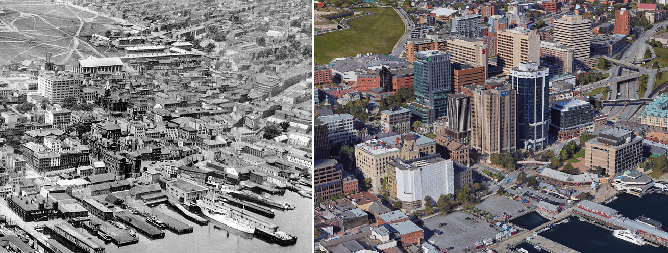
Firstly, I overlaid a 1962 map on the current Google map to show the approximate position of the old street grid compared to today:


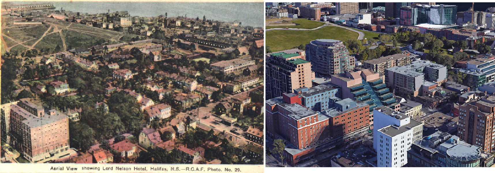
Next, I sketched out approximate locations of old streets onto an overhead view of Scotia Square from Google Maps:


https://www.google.ca/maps/@44.64937.../data=!3m1!1e3

If you zoom into the "Buckingham Street Corridor" area of Scotia Square, you can see picnic tables, one of which is also visible at the top of your photo. I'm assuming that this is perhaps the approximate location of your photo?


https://www.google.ca/maps/@44.64978.../data=!3m1!1e3

Now, if you look at some 1945 photos of the intersection between Buckingham Street and Argyle Street, you can see that there once was cobblestones there:


Caption: Argyle St. at Buckingham, looking north-north-east
Sept. 21, 1945 (102-16N-0016.27)


Caption: Argyle St. looking north from just south of Buckingham St.
Sept. 21, 1945 (102-16N-0016.26)

These are from the Halifax Municipal Archives site (search word: Buckingham): Halifax Municipal Archives

A few observations:
(1) The original intersection as shown in the photos is at somewhat of a slope and there are trolley tracks at that location - both of these features are not visible in your photo.
(2) The location of the intersection appears to be a little too southward to be located right next to the picnic tables (if they are the same ones), though it appears that the cobblestones ran the length of Buckingham at the time.
(3) The cobblestones in the photos run in 2 directions, depending on their proximity to the tracks. Again not a feature that is visible in your photo.
(4) It seems likely that the cobblestones would have been paved over sometime in the 1950s or 1960s as seen in later photos of Buckingham Street.

Checking into it a little further, from the Scotia Square construction photos (also from the Municipal Archives), you can see that the surfaces and below-grade areas of Argyle and Buckingham Streets were removed during construction:


My best guess would be that they may have saved original cobblestones from that area and laid them there during finish construction - though it seems like an odd place to put them...

Thanks for posting the photo - it shows a very intriguing feature of Scotia Square that I had not been aware of.
Reply With Quote
     
     
  #627  
Old Posted May 16, 2017, 10:22 PM
fenwick16 fenwick16 is offline
Honored Member
 
Join Date: Feb 2007
Location: Toronto area (ex-Nova Scotian)
Posts: 5,558
^^^ Great construction pictures.

Seeing Scotia Square being built in the late 1960's and 1970's must have been an exciting time for many Haligonians and Nova Scotians. I remember in the mid 1970's, one of the TV news stations would show an aerial of Scotia Square as a lead-in to the news, and it always made me proud to be a Nova Scotian ; although this may seem odd to some if this were not a skyscraper forum.
Reply With Quote
     
     
  #628  
Old Posted May 17, 2017, 2:37 PM
eastcoastal eastcoastal is offline
Registered User
 
Join Date: Mar 2009
Posts: 1,238
Quote:
Originally Posted by MPotter View Post


Here is a photo I took last fall in the Scotia Square parkade. I wonder if the cobblestones in the photo are part of the old Buckingham Street or perhaps Jacob Street?

I would be interested to learn more about them.
I was told once that they were original to the streets in the area, that they were removed during demolition and reinstalled as part of the project, and that they were supposed to be part of maintaining the original street grid THROUGH the new building complex.
Reply With Quote
     
     
  #629  
Old Posted May 17, 2017, 4:49 PM
OldDartmouthMark OldDartmouthMark is offline
Registered User
 
Join Date: May 2010
Posts: 8,458
Quote:
Originally Posted by eastcoastal View Post
I was told once that they were original to the streets in the area, that they were removed during demolition and reinstalled as part of the project, and that they were supposed to be part of maintaining the original street grid THROUGH the new building complex.
Thanks for that. I was thinking of our conversation a few pages back when I was checking into it. The photos above are consistent with the information that your colleague had given you.

Again, until it was discussed here, I was never aware that there was an attempt to maintain the original street grid through SS. I love learning details like this.

Next time I'm around SS I must take a walkabout to see if I can discover any more details related to the street grid.
Reply With Quote
     
     
  #630  
Old Posted May 17, 2017, 5:51 PM
beyeas beyeas is offline
Fizzix geek
 
Join Date: Aug 2007
Location: South End, Hali
Posts: 1,303
Quote:
Originally Posted by fenwick16 View Post
Very interesting. Is this part of the entrance off Market Street, I don't recognize this area?

As a teenager, in the early to mid 1970's, I worked at Scotia Square during the summers in the maintenance department doing various dirty jobs such as sweeping the parking level fan rooms (a terribly dirty job), sweeping and applying a sealant to the parkade floors, cleaning out junk, watering bushes ... So I got to know Scotia Square fairly well, so I am interested in knowing where these cobblestones are.
They repaved my street and redid sidewalks a couple of years ago, and when they tore up the sidewalk there were tons of cobblestones underneath. I grabbed about 10 before they were covered over again and kept them! Now I used them to hold my backyard gate open etc. It was pretty cool to find them.
Reply With Quote
     
     
  #631  
Old Posted May 17, 2017, 8:51 PM
fenwick16 fenwick16 is offline
Honored Member
 
Join Date: Feb 2007
Location: Toronto area (ex-Nova Scotian)
Posts: 5,558
Quote:
Originally Posted by beyeas View Post
They repaved my street and redid sidewalks a couple of years ago, and when they tore up the sidewalk there were tons of cobblestones underneath. I grabbed about 10 before they were covered over again and kept them! Now I used them to hold my backyard gate open etc. It was pretty cool to find them.

I wonder what year the cobblestones are from? I guess you could approximate the year by the age of your neighbourhood. The south end would have been late 1800's, early 1900's depending on the street, similar to Dalhousie University (or so I assume).
Reply With Quote
     
     
  #632  
Old Posted May 18, 2017, 4:11 AM
beyeas beyeas is offline
Fizzix geek
 
Join Date: Aug 2007
Location: South End, Hali
Posts: 1,303
Quote:
Originally Posted by fenwick16 View Post
I wonder what year the cobblestones are from? I guess you could approximate the year by the age of your neighbourhood. The south end would have been late 1800's, early 1900's depending on the street, similar to Dalhousie University (or so I assume).
My house was about 1920. Not 100% sure on when the street was opened, but certainly before that. I've seen a map from 1879 that has my street on it, but there were no houses yet! It also did not connect through yet to any other streets. The area that I am in used to be an apple orchard, and the oldest house that we know of on my block was built in 1901 as a farmhouse for the orchard. The house I live in is a Craftsman style, and in talking to another home owner I learned that many of the homes on the street were built by shipbuilder carpenters who were being laid off because of the rise of steel ships. Not surprising then that mine got built as a craftsman style and not anything ornate!
Reply With Quote
     
     
  #633  
Old Posted May 18, 2017, 4:25 AM
alps's Avatar
alps alps is offline
Registered User
 
Join Date: Sep 2006
Location: Hong Kong
Posts: 1,567
Quote:
Originally Posted by OldDartmouthMark View Post

If you zoom into the "Buckingham Street Corridor" area of Scotia Square, you can see picnic tables, one of which is also visible at the top of your photo. I'm assuming that this is perhaps the approximate location of your photo?
The pic was taken in the "Jacob Street Corridor", just outside a back entrance to the Delta lobby.
Reply With Quote
     
     
  #634  
Old Posted May 18, 2017, 12:31 PM
OldDartmouthMark OldDartmouthMark is offline
Registered User
 
Join Date: May 2010
Posts: 8,458
Quote:
Originally Posted by alps View Post
The pic was taken in the "Jacob Street Corridor", just outside a back entrance to the Delta lobby.
Thanks! It was hard to tell from the aerial view exactly where it was taken. I haven't gone through that area, but I'm wondering if the Buckingham St. area would have the same embellishment with cobblestones. I'll have to check it out one of these days.
Reply With Quote
     
     
  #635  
Old Posted May 18, 2017, 3:11 PM
OldDartmouthMark OldDartmouthMark is offline
Registered User
 
Join Date: May 2010
Posts: 8,458
Quote:
Originally Posted by beyeas View Post
My house was about 1920. Not 100% sure on when the street was opened, but certainly before that. I've seen a map from 1879 that has my street on it, but there were no houses yet! It also did not connect through yet to any other streets. The area that I am in used to be an apple orchard, and the oldest house that we know of on my block was built in 1901 as a farmhouse for the orchard. The house I live in is a Craftsman style, and in talking to another home owner I learned that many of the homes on the street were built by shipbuilder carpenters who were being laid off because of the rise of steel ships. Not surprising then that mine got built as a craftsman style and not anything ornate!
Interesting history there. Did a tram line run by your place? I don't have good information on this at the moment, but from old photos I've seen cobblestones were usually located around the tram tracks, whereas many other roads were left unpaved. I'm not sure at what point cobblestones were added, and whether they were used as paving for main streets without Birney tracks, though. There are a lot of photos from the late 1800s and early 1900s on the archives that show dirt roads in the downtown area, and I recall reading council minutes from the early 1920s that discussed paving projects such as South Park Street, for example.
Reply With Quote
     
     
  #636  
Old Posted Jun 5, 2017, 5:40 PM
OldDartmouthMark OldDartmouthMark is offline
Registered User
 
Join Date: May 2010
Posts: 8,458
Quote:
Originally Posted by OldDartmouthMark View Post
Ok, let's turn this thread back to something more positive.

Ever see an empty lot and wonder what used to be there? I've been driving and walking by this one on Barrington near Morris for years and never knew what used to be there... until now.

The empty lot in question:
https://www.google.ca/maps/@44.64152...8i6656!6m1!1e1

What used to be there...


http://gencat1.eloquent-systems.com/webcat/request/DoMenuRequest?SystemName=Halifax+Regional+Municipality+Archives&UserName=WA+Public&Password=&TemplateProcessID=6000_20185_20185&CMD_(SearchRequest)[11]=&PromptID=&ParamID=&RequesterType=SearchTemplate&browseData=1&Keyword=0&SearchLogic=%26Logic%3D%26S1%3DPOI1_1225%261POI1_1225%3D827

--->Search for "1273-77 barrington"
Found another photo on the Municipal archives site from a distance, in its pre-fire state, just for interests sake (search for 1236 Barrington at the link above). The building can be seen in the background, between the 2 workers in the street:

Reply With Quote
     
     
  #637  
Old Posted Jul 22, 2017, 5:41 PM
someone123's Avatar
someone123 someone123 is offline
hähnchenbrüstfiletstüc
 
Join Date: Nov 2001
Location: Vancouver
Posts: 33,694
I tried to create some "before and after" aerials using Google's 3D view:


Reply With Quote
     
     
  #638  
Old Posted Jul 22, 2017, 6:48 PM
fenwick16 fenwick16 is offline
Honored Member
 
Join Date: Feb 2007
Location: Toronto area (ex-Nova Scotian)
Posts: 5,558
^^^ Interesting. Nice work someone123.
Reply With Quote
     
     
  #639  
Old Posted Jul 22, 2017, 7:43 PM
someone123's Avatar
someone123 someone123 is offline
hähnchenbrüstfiletstüc
 
Join Date: Nov 2001
Location: Vancouver
Posts: 33,694
Another:

Reply With Quote
     
     
  #640  
Old Posted Jul 22, 2017, 9:52 PM
TheGreenBastard's Avatar
TheGreenBastard TheGreenBastard is offline
Registered User
 
Join Date: Nov 2015
Location: Halifax/Toronto
Posts: 177
Quote:
Originally Posted by someone123 View Post
Another:


This is the closest I've seen to construction photos of Purdy's Wharf. Am I just bad at searching?
Reply With Quote
     
     
This discussion thread continues

Use the page links to the lower-right to go to the next page for additional posts
 
 
Reply

Go Back   SkyscraperPage Forum > Regional Sections > Canada > Atlantic Provinces > Halifax > Halifax Photos
Forum Jump


Thread Tools
Display Modes

Forum Jump


All times are GMT. The time now is 4:09 PM.

     
SkyscraperPage.com - Archive - Privacy Statement - Top

Powered by vBulletin® Version 3.8.7
Copyright ©2000 - 2024, vBulletin Solutions, Inc.