HomeDiagramsDatabaseMapsForum About
     

Go Back   SkyscraperPage Forum > Regional Sections > Canada > Atlantic Provinces > Halifax > Halifax Photos


Reply

 
Thread Tools Display Modes
     
     
  #901  
Old Posted Apr 10, 2019, 2:21 PM
JET JET is offline
Registered User
 
Join Date: Feb 2007
Posts: 1,814
A horse-drawn street railway connected the (Richmond) station to the downtown.
https://en.wikipedia.org/wiki/Halifa...n_(Nova_Scotia)
"The North Street Station and the waterfront terminal trackage leading to it were badly damaged in the Halifax Explosion on 6 December 1917. "
horse drawn railway to avoid fires from the train embers
Reply With Quote
     
     
  #902  
Old Posted Apr 10, 2019, 3:17 PM
OldDartmouthMark OldDartmouthMark is offline
Registered User
 
Join Date: May 2010
Posts: 8,472
Quote:
Originally Posted by JET View Post
Perhaps a bit of both?, starting at the corner of North/Barrinton, and then extending North into the current parking lot?
Yes, I believe you are correct. I was looking at the map but ignoring the photo showing the edge of the hotel actually extending a little further south than the station. I retract my previous statement.

Reply With Quote
     
     
  #903  
Old Posted Apr 10, 2019, 6:19 PM
OldDartmouthMark OldDartmouthMark is offline
Registered User
 
Join Date: May 2010
Posts: 8,472
Quote:
Originally Posted by Keith P. View Post
Mark, seeing all of these maps has caused a question to develop.

The Intercolonial Station maps all show the rail line ending at the station just before the spot where North St descends towards Upper Water St as it was back then. But I recall seeing a later aerial photo of the downtown, I think one of the ones taken prior to or during the demolition of properties for the Cogswell interchange and Scotia Square development in the 1960s, that showed a line extending to the very edge of downtown, close to Cogswell.

Any idea how that was routed from the North St area to there? It did not seem to exist at the time of the explosion.
Hmmm.... good point, Keith.

This reminds me of a post I made in this thread about 5 years ago, back on page 16: http://forum.skyscraperpage.com/show...&postcount=303

It doesn't show up on the 1878 Hopkins Atlas maps, but the later 1894 map from my linked post shows a line branching off just before the station and pretty much following Upper Water Street down to the Deep Water Terminus, where the grain elevator was located (the grain elevator was also mentioned in the explosion damage articles posted above), which was almost to Cornwallis Street.


You can see some of this track system in this photo from the Halifax Municipal Archives from the early 1970s:


Halifax Municipal Archives

I'm going to assume that this track extension was built to work with the deep water docks, after the atlas maps were made, but I don't have good info on this. All indications I've seen are that it didn't go any further south than this, but I'm open to be corrected.

For anybody interested, the NS Archives has a photo showing the grain elevator from which the photo in the linked post was taken, which was also the end of the rail line on the map.


Zoomable original: https://novascotia.ca/archives/Notma...ves.asp?ID=732


https://novascotia.ca/archives/Conno...ves.asp?ID=767

An interesting one of Helen Creighton on the roof of a pier looking back towards Halifax with the grain elevator in the background:


https://novascotia.ca/archives/Creig...ves.asp?ID=497

And another view towards Dartmouth from the grain elevator in 1890:


https://novascotia.ca/archives/Notma...ives.asp?ID=54

One more of the area from 1928:


https://novascotia.ca/archives/MacAs...es.asp?ID=2494

Last edited by OldDartmouthMark; Oct 21, 2019 at 6:59 PM.
Reply With Quote
     
     
  #904  
Old Posted Apr 10, 2019, 6:45 PM
Keith P.'s Avatar
Keith P. Keith P. is offline
Registered User
 
Join Date: Mar 2006
Posts: 8,014
Thank you for that! The photos go far beyond what I expected to see. Remarkable that the lines went right to the end of each of the wharves.

What a shame how that rail connection to the downtown has been lost.
Reply With Quote
     
     
  #905  
Old Posted Apr 10, 2019, 7:14 PM
OldDartmouthMark OldDartmouthMark is offline
Registered User
 
Join Date: May 2010
Posts: 8,472
No problem. It's a learning experience for me also. Plus a chance to tie in some other photos I've seen in passing. They have much more meaning to me when I can attach some context to them.
Reply With Quote
     
     
  #906  
Old Posted Apr 10, 2019, 7:42 PM
ns_kid's Avatar
ns_kid ns_kid is online now
Registered User
 
Join Date: Sep 2013
Posts: 491
Quote:
Originally Posted by OldDartmouthMark View Post
One more of the area from 1928:
Thank you for more wonderful images, Mark.

That last one is significant. I thought it was worth pointing out that what we are looking at is Pier 2, which was the main immigration pier until Pier 21 was built in 1928. The immigration shed in the photo opened in 1915, replacing one damaged by fire, just in time to serve as the main point of departure (and return) for thousands of sailors and soldiers bound for the war in Europe. And of course it was heavily damaged in the 1917 Explosion, though returned to service after that. Historian Craig Dodge estimates 2.7 million people immigrated to Canada through Pier 2. It's interesting to see in the photo a passenger train apparently departing the pier.

Here is a photo of Pier 2 taken in the 60s. (The archives caption dates it as circa 1960, but the vacant lands in the redevelopment area and the CN "wet noodle" logo visible on a box car suggest it's closer to 1965). The rail sidings were still in use, as you can see, and terminated at the foot of Cornwallis Street. I am old enough to remember the tracks beneath the Macdonald Bridge still full of rail cars as late as, I think, the early 1970s, perhaps as late as the mid-to late 70s when I was travelling daily from Dartmouth to Dal. Unfortunately, I can't really recall when they were finally pulled up. But I always thought it was a shame to lose a potential commuter rail corridor to the north edge of downtown.


Source: Nova Scotia Archives

I've only been able to locate the Craig Dodge essay about Pier 2 in French.

Last edited by ns_kid; Apr 10, 2019 at 8:03 PM.
Reply With Quote
     
     
  #907  
Old Posted Apr 10, 2019, 9:19 PM
OldDartmouthMark OldDartmouthMark is offline
Registered User
 
Join Date: May 2010
Posts: 8,472
Fascinating. I've heard so much of Pier 21, but almost nothing about Pier 2. Thanks for that. This helps to put the pieces together of the almost wholesale shift of rail and shipping activity from the north end to the south end during the period of the late teens through the twenties.

North Street Station --> South end station/rail cut
King Edward Hotel --> Hotel Nova Scotian
Grain elevator north end --> south end
Pier 2 --> Pier 21
Deep Water Terminus --> Ocean Terminals/Halterm etc.

About the only thing that didn't move, it seems, is the military.

Interesting point about the troop movement at Pier 2 as I found this pic on the NS Archives of the Aquitania loading troops at Pier 2...

Reply With Quote
     
     
  #908  
Old Posted Apr 11, 2019, 11:51 AM
ns_kid's Avatar
ns_kid ns_kid is online now
Registered User
 
Join Date: Sep 2013
Posts: 491
Please excuse the length of this one, but I made reference earlier to an interesting essay by Craig Dodge for Pier 21 Museum. I could only locate a French version of the text but I thought it added some value so I attempted a reasonable facsimile of a translation...

Remembering Pier 2: The Other Immigrant Gateway to Halifax
by Craig Dodge, Canadian Museum of Immigration at Pier 21

Before Pier 21 became the gateway to Halifax for one million immigrants arriving on Canada's East Coast, for several years another facility filled the role of access point to the city for newcomers.

Because its history is less known than its famous successor, Pier 2 remains largely forgotten. That’s a shame, considering the contribution of this facility to the country’s growth. Nearly 2.7 million people1 immigrated to Canada during Pier 2’s years of service, most of them crossing the Atlantic from Europe, and Halifax was more often than not their point of entry.2 During these years, Pier 2 was there to welcome them. If its history remains little known, it must also be added that it can be difficult to trace. Often conflicting and contradictory, sometimes vanished or hidden, the history of Pier 2 continues to be a fascinating excursion into the past of the city and the country.

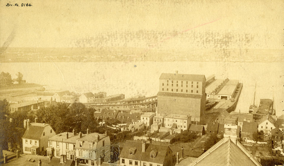
The history of Pier 2 is inseparable from the stories of the disasters that have marked the region over the years. Each of these tragedies is embodied in this wharf. While it’s likely that wharves existed in Halifax’s north end beyond Cornwallis Street before records were kept, it is not until 1880 that it is possible to document with certainty the historic beginnings of Pier 2. A dispatch from the February 4 edition of the Journal of Remarkable Occurrences for 1880-1881 states that "during the fourteenth and fifteenth years following the Canadian Union, the deepwater terminal of the Intercolonial Railway in Halifax, Nova Scotia, was completed by James G. Kennedy, Contractor. Work had begun in June, 1877 and the value of the contract was $174,000”.3

This short report, in addition to providing information on the beginnings of Pier 2, is important for another reason. The term "deep-water terminal" was used to identify Pier 2 for several years. The name was considered appropriate because of the dock’s location, one mile closer to the open sea than the government railway’s other terminals, located further north. Although the depth of the water at Pier 2 does not really exceed that of other areas of the harbor, during its first years of existence the wharf was known as "Deepwater". The name describes the ideal location because of the requirements of the many ships that often came to Halifax.

The property on which Pier 2 was located belonged to and was operated by the company of Samuel Cunard, founder of the famous steamship line. The structure, including the wharf, the rails and the open warehouse, received a boost when, in the year it was completed, Halifax was officially proclaimed by Ottawa to be a "port of entry". In fact, under the Canadian Immigration Act, the city had hosted an immigration office since 1865. The local newspapers of the time reported the expansion of the wharf. A year after its construction, the Halifax Herald published a glowing assessment of recent additions to the terminal. Equipped with a new hangar measuring 546 feet long and 46 feet wide, big enough to accommodate a greater volume of coal, the newspaper proudly states: "When the work in progress is completed, Halifax will have marine transportation facilities beyond all other ports in the Dominion, and in fact, according to some, all over North America."4

The new wharf, however, suffered its first major disaster in [1895] when a fire, suspected of being arson, ravaged the structure. When the wharf was finally rebuilt under the auspices of the Laurier government seeking to develop the port of Halifax, the work took on an even bigger dimension.

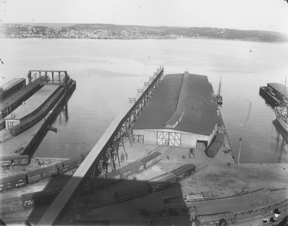
Construction began in September 1911 and was completed in early 1915. Resident Engineer A.F. Dyer and Superintendent A. A. MacDonald supervised the project. These two people later renewed their association during a future reconstruction of the wharf. The new wharf and hangar were built entirely of reinforced concrete. It was around this time that the wharf began to be called Pier 2. Everything was in place for the facility to receive both immigrants and goods.

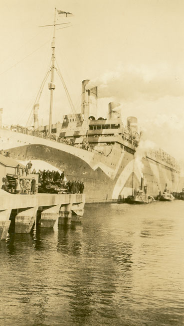
The wharf was completed a year after the First World War erupted and suddenly found itself playing an unexpected role. “From the beginning of 1915 to the return of the Canadian soldiers of the war, the main purpose of the wharf was to accommodate the troops. Virtually all Canadians who went to fight for the Empire boarded at this dock.”5 On the upper floor of its transit hangar, “284,455 Canadian soldiers, many American soldiers and more than 50,000 Chinese construction workers embarked at Pier 2" during the war. 
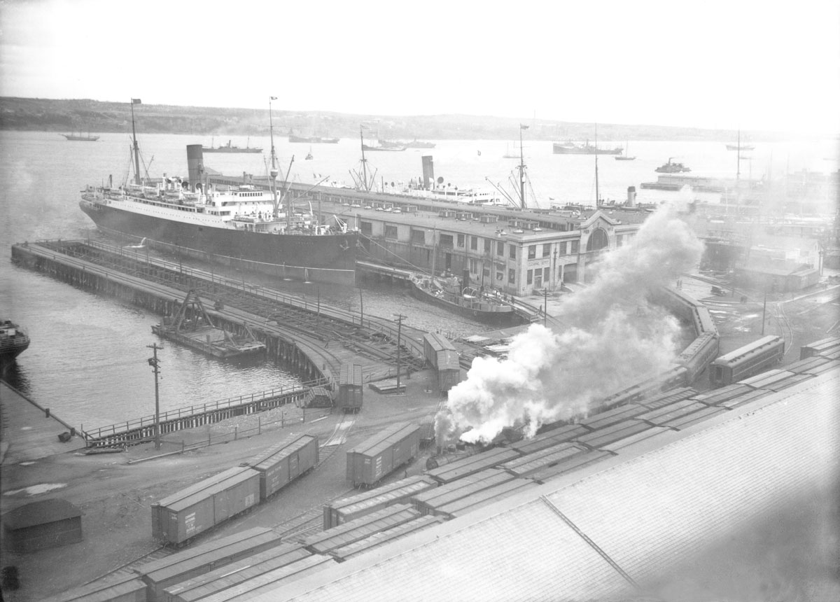
6 A hospital was installed on the upper floor to treat the sick and wounded. At that time, the wharf became the heart of the city. A convoy of ships and people converged each day in Halifax’s north end. Probably the most famous ship that regularly docked there to take on thousands of passengers was "the Olympic, sister ship of the infamous Titanic. By the spring of 1919, more than 6,000 veterans disembarked from this ship at Pier 2, setting a new passenger transport record.”7

A new disaster struck the wharf in 1917, when the entire north end of Halifax was reduced to ruins by the largest man-made explosion before the bombing of Hiroshima in 1945. Although the concrete shed survived better than most of the surrounding structures, the damage was so high that the wharf's capacity to receive immigrants was considerably reduced over the next 10 years. People who arrived in Halifax during this period, at their first glance at their new home, saw the desolate landscape of a ruined city. Without a doubt, this scene could "not leave the happiest impression."8

For a while, Pier 2 continued to handle the flow of immigrants to Canada, but eventually a new wharf called Pier 21 was built to move the city's immigration traffic further south along the harbour. By 1926, the new wharf was finished, part of the port complex known as Ocean Terminal. The Department of Immigration and Settlement was in such a hurry to move its facilities to the new location that, even before the new Halifax Harbour Commission was able to take over management of the Ocean Terminal facilities, the federal immigration offices were in place and operating on the second floor of the new shed.9 In 1928, Pier 21 officially began its long career as Canada's most famous entry point.

Although the Pier 2’s role as an immigration facility eventually ended, its story continued in a more familiar role. During the First World War, the upper floor served as a temporary shelter for thousands of new immigrants. After it was no longer needed for this purpose, it gradually fell into disrepair. However, in the late 1920s, as the demand for trade with the Great Lakes region increased, the wharf was rebuilt again. Developed as a 1.5 million cubic feet storage facility for food and goods, the wharf was assured of a bright future in Halifax's marine economy. But another tragedy would challenge the wharf’s survival, following a familiar scenario.

In September 1933 "the most spectacular and difficult fire to control Halifax has seen since the Holocaust of [1917]"10 occurred on the upper deck of the wharf. The result was a financial loss of more than half a million dollars, a potentially fatal blow to Halifax's vibrant transportation industry. However, a determined and concerted effort by business and government overcame contractual disputes and bad winter weather and restored normal operations at Pier 2. The wharf, according to Harbour Commissioner J.L. Hetherington, was raised to a level "never before reached".11 A ramp was built to provide vehicles with access to the upper floor, electric escalators were installed between floors, and improved plumbing and heating systems were added. But the glory years of this old wharf in Halifax's north end, where so many immigrants once came to Canada, would not last.

There would be no other calamity, but inevitably its time drew to a close. Today, the transit shed has long since disappeared and the old rails are unusable, but the wharf still occupies the position it had in the winter of 1880. Today, the Canadian Navy has taken over the location and few signs of its important past remain, but Pier 2’s vibrant history is still worth recalling.


Some facts about Pier 2

A short chronology

February 4, 1880- Beginning of the "Deep Water Terminal"
January 6, 1885- Construction of a coal shed for the Intercolonial Railway
May 20, 1895- A fire possibly of criminal origin caused serious damage
September 1911- Start of construction of Pier 2 facilities
Aug. 1914 to Nov. 1918- Serves embarkation point for Canadian troops departing overseas
Winter 1915- Completion of construction of Pier 2 facilities
6 December 1917- Most of Pier 2 is destroyed by Halifax Explosion
March 1928- Immigration offices officially transferred to Pier 21
September 1933- Fire causes half a million dollars in damage and destroys warehouse upstairs
October 1934- Wharf resumes commercial role "better than before"
September 1939- Canada enters the Second World War and the navy requisitioned Pier 2 facilities

The location of Pier 2
Throughout its history, Pier 2 has been located in the north end of Halifax, near the shore at the end of Cornwallis Street.

The dimensions of Pier 2
The Halifax Herald of September 1, 1882 gives the dimensions of the original storage shed at 546 feet long by 46 feet wide. It was 16 feet tall and had a flat roof. The October 1933 "The Port and Province" newspaper describes the transit shed of Pier 2 during the post-1911 period as having 1.5 million cubic feet of storage space on the upper floor. The dock footprint is described as 700 feet long and 235 feet wide. The transit hangar is described as 688 feet long and 200 feet wide. It is reported that the cost of the structure is approximately $1.2 million. (It should be noted that the Halifax Harbour Commission, in its 1928 annual report, mentions slightly different statistics, 700 feet long by 225 feet wide with a warehouse 694 feet by 202 feet.)


Footnotes

1 This value is based on information provided by Statistics Canada. It includes the number of immigrants between the years 1911 and 1928 inclusively. These statistics could be increased to 5.5 million people back to 1880, the year the predecessor of Pier 2, the deep-water Terminal, was inaugurated. SOURCE: 1852 to 1976, Department of Manpower and Immigration, Immigration Statistics 1976, Table 2, p. 4, Ottawa, 1977; for 1977, Employment and Immigration Canada, Immigration 1977, Quarterly Statistics, Fourth Quarter, Table 2, p. 7
2 The Pier 21 Story: Halifax 1924-1971, (Halifax: Employment and Immigration, 1978), p .2. Available from the Pier 21 Documentation Center.
3 "Dominion Annual Register for 1880-81", Journal of Remarkable Occurrences, v.237. Available from the Archives and Records Management of Nova Scotia.
4 "Additions to the Wharf and Deep Water Terminus", Halifax Herald, September 1, 1882, p. 2. Available from the Archives and Records Management of Nova Scotia.
5 H. Hyatt, Port Authority's Vigorous Action Averts Business Disaster, Port and Province, (October 1933), pp. 7, 26-7. Available from the Archives and Records Management of Nova Scotia.
6 Ibid.
7 Ibid.
8 The Pier 21 Story, 4.
9 "Report for the Year 193", Halifax Harbor Commissions Annual Reports, 1928-35, p. 12. Available from the Archives and Records Management of Nova Scotia.
10 Port and Province, 6.
11. Chas S. Bennett, "Fires Destruction of the Historic Pier Turned to Advantage", Port and Province, (February 1934), p. 4. Available from the Archives and Records Management of Nova Scotia
Reply With Quote
     
     
  #909  
Old Posted Apr 11, 2019, 12:49 PM
Keith P.'s Avatar
Keith P. Keith P. is offline
Registered User
 
Join Date: Mar 2006
Posts: 8,014
Fascinating article. Thank you for the excellent translation.

It is interesting how the Navy could requisition the wharf property - understandable in the time of war - but then never release it.
Reply With Quote
     
     
  #910  
Old Posted Apr 11, 2019, 7:07 PM
OldDartmouthMark OldDartmouthMark is offline
Registered User
 
Join Date: May 2010
Posts: 8,472
Thanks for posting (and translating) this!

Like many, I suppose, I had no idea of the significance of Pier 2. I've noticed it in passing, and obviously had seen old photos of it, but was not aware of its history or significance until now.
Reply With Quote
     
     
  #911  
Old Posted Apr 15, 2019, 6:19 PM
OldDartmouthMark OldDartmouthMark is offline
Registered User
 
Join Date: May 2010
Posts: 8,472
Here's a 1917 Harbour map found on the Halifax Municipal Archives:
1917 Harbour Map on HRArchives

I cropped the area around the train station and Pier 2 to show location detail around the time of the explosion, which clearly shows the rail lines extending past Cornwallis Street:

Reply With Quote
     
     
  #912  
Old Posted Apr 15, 2019, 6:25 PM
OldDartmouthMark OldDartmouthMark is offline
Registered User
 
Join Date: May 2010
Posts: 8,472
Additionally, here is a photo of what I believe to be Pier 2 from 1981, looking to be near the end of its lifespan:


City of Halifax fonds
Halifax (N.S.). Committee on Works records
Halifax (N.S.) Works Department photographs
2099 Upper Water St.
Retrieval code: 102-39-1-1351
1981-12
Reply With Quote
     
     
  #913  
Old Posted Apr 16, 2019, 5:53 AM
someone123's Avatar
someone123 someone123 is offline
hähnchenbrüstfiletstüc
 
Join Date: Nov 2001
Location: Vancouver
Posts: 33,694
Here's a twitter post about the circa 1830 house at Morris and Queen, including a picture from around 1900:

https://twitter.com/Cove17/status/1117171225527226374

It's not clear what work will be done but some of the siding has been removed. It's an understated building but still interesting, particularly the curved corner. In some ways the older Georgian buildings are more modern looking than Victorians built 50 years later.

The 90's style light blue vinyl siding townhouses next door could use some work too. They'd look great with a sympathetic third storey addition and wood siding.
Reply With Quote
     
     
  #914  
Old Posted Apr 16, 2019, 1:57 PM
OldDartmouthMark OldDartmouthMark is offline
Registered User
 
Join Date: May 2010
Posts: 8,472
Interesting. It looks like the scope of the project is just on the residential side, though it would be nice if it included the entire building. It looks like the rounded corner on the store side is still hiding behind the sign. It would be nice for the viewer if the signage could be moved and replaced with something more fitting to the building, so that the corner could be revealed again, but of course that would be up to the business owner, as it would be an expense to the business.

Certainly, the decorative elements of Victorian architechture does date it, but that is also the charm. Georgian Architecture seems to be more focused on function, simple yet attractive, which I think are elements more common in modern buildings.

Either way, it's nice to see some restoration happening on the wooden structures that are so much more ubiquitous in Halifax than stone buildings, but make up the fabric of our older neighborhoods. The fact that this building dates to the 1830s and is still being used as a residence speaks volumes about its build quality. Looks like it should be good for another century or so...
Reply With Quote
     
     
  #915  
Old Posted Apr 16, 2019, 10:12 PM
essaysmith's Avatar
essaysmith essaysmith is offline
Registered User
 
Join Date: Feb 2012
Location: HRM
Posts: 50
It looks like the tracks end at Proctor Street in the picture. You can see the 12 Apostles row houses at the end of the street.
Reply With Quote
     
     
  #916  
Old Posted Apr 16, 2019, 10:26 PM
OldDartmouthMark OldDartmouthMark is offline
Registered User
 
Join Date: May 2010
Posts: 8,472
Reply With Quote
     
     
  #917  
Old Posted May 1, 2019, 1:28 PM
OldDartmouthMark OldDartmouthMark is offline
Registered User
 
Join Date: May 2010
Posts: 8,472
Here's a photo that ties into the North Street station discussion. You can see the trackage from the North street station still in existence at the north side of the bridge.

The photo is dated 1955, and shows the Macdonald Bridge nearing completion. Since the opening date for the bridge was April 2, 1955, and given the lack of snow in the photo, I believe this places the photo in mid-late March.


https://novascotia.ca/archives/NSIS/archives.asp?ID=666


Gratuitous photo of opening day on the Mac-D bridge:


https://novascotia.ca/archives/Halif...ves.asp?ID=124
Reply With Quote
     
     
  #918  
Old Posted May 13, 2019, 3:57 PM
OldDartmouthMark OldDartmouthMark is offline
Registered User
 
Join Date: May 2010
Posts: 8,472
Quote:
Originally Posted by someone123 View Post
Here's a twitter post about the circa 1830 house at Morris and Queen, including a picture from around 1900:

https://twitter.com/Cove17/status/1117171225527226374

It's not clear what work will be done but some of the siding has been removed. It's an understated building but still interesting, particularly the curved corner. In some ways the older Georgian buildings are more modern looking than Victorians built 50 years later.

The 90's style light blue vinyl siding townhouses next door could use some work too. They'd look great with a sympathetic third storey addition and wood siding.
Interestingly, this building shows up in a few places on the Municipal Archives.

Here's one labled:
Quote:
5560 Morris St.
Retrieval code: 102-39-1-1050
[1964]
...that shows the wider siding that you can see layered in the pics on twitter. It's hard to tell from the photo whether the curved corner had already been covered over, but I imagine it had for ease of installing the siding.


In another photo labeled
Quote:
5561 Morris St.
Retrieval code: 102-39-1-1051
[between 1957 and 1962?]
...you can see how the commercial side of the building looked in the sixties, but the corner is somewhat obscured by the power pole in the foreground.


A bit of a change from how it looked in 1900:


I'm curious of the shots, in a photoset labeled:
Quote:
Queen St. [between Morris St. and Spring Garden Rd.]
Retrieval code: 102-39-1-1138
[between 1957 and 1961]
...where you can see a masonry chamber below the sidewalk on the Queen Street side. Presumably this was to store coal? Anybody know more about chambers like this? It reminds me a little of the vault that was found next to Province House in February.


Additionally, the building can be seen at the left of this aerial shot of The Infirmery shot in 1970.

Reply With Quote
     
     
  #919  
Old Posted May 14, 2019, 10:03 PM
OldDartmouthMark OldDartmouthMark is offline
Registered User
 
Join Date: May 2010
Posts: 8,472
Interesting then and now comparison:

From the NS Archives:

Quote:
"Union Engine Company, No. 6 (Alma), in dress uniform, with No. 3 Steam Fire-engine and the old Hand Fire engine 'Alma' of about 1855; in front of Queen St. Engine House, 52 Queen St., Halifax, on the occasion of a firemen's tournament, ca. 1878"


"Now" (Google Maps Aug. 2018)

Reply With Quote
     
     
  #920  
Old Posted May 15, 2019, 3:01 PM
OldDartmouthMark OldDartmouthMark is offline
Registered User
 
Join Date: May 2010
Posts: 8,472
Reply With Quote
     
     
This discussion thread continues

Use the page links to the lower-right to go to the next page for additional posts
 
 
Reply

Go Back   SkyscraperPage Forum > Regional Sections > Canada > Atlantic Provinces > Halifax > Halifax Photos
Forum Jump


Forum Jump


All times are GMT. The time now is 9:54 PM.

     
SkyscraperPage.com - Archive - Privacy Statement - Top

Powered by vBulletin® Version 3.8.7
Copyright ©2000 - 2024, vBulletin Solutions, Inc.