HomeDiagramsDatabaseMapsForum About
     

Go Back   SkyscraperPage Forum > Photography Forums > Found City Photos

Reply

 
Thread Tools Display Modes
     
     
  #48481  
Old Posted Aug 24, 2018, 11:34 PM
Handsome Stranger's Avatar
Handsome Stranger Handsome Stranger is offline
Registered User
 
Join Date: May 2011
Location: Los Angeles, CA
Posts: 395
Forgive me for veering off-topic for a moment, but I thought this was a quintessential Los Angeles story.

There was a nasty accident on the westbound 105 freeway at about 5:15 this morning. Traffic was halted in both directions for a few hours.

Some of the stranded motorists noticed that a taco truck was among the vehicles stopped there. So they got out of their cars and asked if they could order breakfast. "El freeway so paro con la explosion and they ended up stuck there with everyone else. And since people knew we had food, people started approaching us and asking for something to eat!"

The taco truck served up dozens of breakfast burritos before the freeway was reopened.


[source: twitter]
Reply With Quote
     
     
  #48482  
Old Posted Aug 25, 2018, 12:01 AM
Martin Pal Martin Pal is offline
Registered User
 
Join Date: Sep 2013
Posts: 2,449


I love that story!
Reply With Quote
     
     
  #48483  
Old Posted Aug 25, 2018, 12:02 AM
Martin Pal Martin Pal is offline
Registered User
 
Join Date: Sep 2013
Posts: 2,449
Quote:
Originally Posted by HossC View Post
You didn't give a time frame or area, but the 1956 CD lists the Comet Club at 1651 Cahuenga Boulevard (just south of Hollywood Boulevard). From 1960 to 1967 it's listed as Club Comet. The 1968 and 1969 CDs have something called The Happy Hour there, and by 1973 it's Speak 39. Jump forward to 1987 and it's Hollywood Video. As you can see from the picture below, 1651 Cahuenga Boulevard is now Cahuenga Video (and has been for at least 10 years).


GSV

Thanks, HossC!

I thought I had checked those CD's once, but I confess they really confuse me more often than not.

The time period would have been the 60's if recollection serves. Sal Mineo wasn't 21 until 1960, but I suppose they might have let him in regardless of age!

I found a Silent Film Location post by John Bengston, where he talks about an early 20's Keaton film titled Cops:

I’ve written frequently about the alley on Cahunega, steps south from Hollywood Boulevard, where Buster grabs a passing car one-handed in Cops, the only movie in Keaton’s oeuvre filmed completely outdoors, showing that Charlie Chaplin (The Kid, 1921), Harold Lloyd (Safety Last!, 1923) and even Harry Houdini (The Grim Game, 1919), filmed there as well.

Moreover, 1651 Cahuenga, the reflected building with the diagonally cropped corner entrance standing across the street from the Keaton stunt site (see reversed image below), once a rubber and vulcanizing store belonging to Harley H. Andrews, is now a porn shop.


John Bengston post

[Cahuenga Alley filming may have been previously mentioned.]

Looking at the present GSV photo provided by HossC and the film article, I notice at the top left is a lighted sign in the shape of a star with a tail cascading down from it...and I wondered if it was previously used for the Comet Club/Club Comet location as comets are often depicted like that, and perhaps it used that adjacent space as well.

The Cinema Treasures Site has this address location listed for a Bijou Theater and describes it thusly:

Located a block off of Hollywood Boulevard, the Bijou Adult Theatre was one of the numerous storefront adult cinemas that popped up in Hollywood during the 1970’s. Period photos depict a relatively small corner unit, with a surprisingly formal cinema marquee; reminiscent of the marquees seen on “classic” mainstream theatres. Programming was billed as “All color hits all nite”, triple features running continuously for a $3 admission price.

The theatre first appeared in independent listings circa 1975 [right after HossC's notation that it's listed as Speak39 in 1973] and continued to regularly advertise throughout the remainder of the decade. With the arrival of home video in the 1980’s, the Bijou Theatre transitioned away from cinema operations and became a standard adult video/magazine store; replacing the formerly impressive marquee signage with a generic retail lightbox. Today, the site operates as the Cahuenga Video Adult Book Store.


http://cinematreasures.org/theaters/44957

I found a photo of this at Hollywood Photographs.


The building does not have that star sign with the tail, so it probably wasn't part of the Comet Club establishment.
Although, the Bijou marquee also has neon stars on it with comet tails...?

Last edited by Martin Pal; Aug 25, 2018 at 5:58 PM.
Reply With Quote
     
     
  #48484  
Old Posted Aug 25, 2018, 12:32 AM
BillinGlendaleCA BillinGlendaleCA is offline
Registered User
 
Join Date: Nov 2016
Posts: 570
Quote:
Originally Posted by Scott Charles View Post
A bit of info I discovered, just in case anyone is interested... I know ER liked the photo below quite a bit.

I spoke yesterday to my aunt Barbara. She was the wife of Jack Diltz, my late uncle, seen below with the hat and the dog.

Barbara confirmed that the Auto Wheel Cafe was in Thousand Oaks. She also said that the business was primarily a gas station. She said that the business had several bungalows in the back, and that they would rent them out to weary travelers.

She also said that the location no longer exists, as it was covered over by the 101 freeway.
(I'm thinking out loud here, Scott...)
I'm puzzled by this a bit, if it was on TO Blvd.* it wouldn't have been displaced by the 101, since the freeway was built a bit to the south of most of TO. The one area where it was built closer to the old road was in Newbury Park near what's now Ventu Park Road. I don't think, from looking at the aerial views, that there was much displacement of business by the freeway itself(there didn't seem to be any businesses north of Newbury Road where; the freeway was built), but there was for interchanges. When they built the Ventu Park offramp in the late 60's they had to move the Stagecoach Inn up the hill from it's original location(after which it promptly burned down).

*I'm kind of assuming it was on the main drag, since it was catering to travelers.
Reply With Quote
     
     
  #48485  
Old Posted Aug 25, 2018, 2:21 AM
ethereal_reality's Avatar
ethereal_reality ethereal_reality is offline
Registered User
 
Join Date: Feb 2008
Location: Lafayette/West Lafayette IN, Purdue U.
Posts: 16,344
Quote:
Originally Posted by odinthor View Post

e_r, I'm seeing SANTA something . . .

edit add: Maybe SANTA PAULA?

edit add, the exciting sequel: The two boards are probably ARRIVALS and DEPARTURES. On the right-hand board (DEPARTURES?),
I think I see SANTA BARBARA as the first destination on the first line of destinations, and li'l old LOS ANGELES as the last destination on the second line of destinations.

edit add, here we go again: And the top line on each board I think says GREYHOUND BUS.
Like this, odinthor?

Reply With Quote
     
     
  #48486  
Old Posted Aug 25, 2018, 3:13 AM
Scott Charles's Avatar
Scott Charles Scott Charles is offline
Registered User
 
Join Date: Jan 2018
Location: Los Angeles
Posts: 495
Quote:
Originally Posted by BillinGlendaleCA View Post
(I'm thinking out loud here, Scott...)
I'm puzzled by this a bit, if it was on TO Blvd.* it wouldn't have been displaced by the 101, since the freeway was built a bit to the south of most of TO. The one area where it was built closer to the old road was in Newbury Park near what's now Ventu Park Road. I don't think, from looking at the aerial views, that there was much displacement of business by the freeway itself(there didn't seem to be any businesses north of Newbury Road where; the freeway was built), but there was for interchanges. When they built the Ventu Park offramp in the late 60's they had to move the Stagecoach Inn up the hill from it's original location(after which it promptly burned down).

*I'm kind of assuming it was on the main drag, since it was catering to travelers.
Interesting, Bill - from what you've said here, I would assume that you are correct (and that aunt Barbara is incorrect) - a gas station with lodging, like the Auto Wheel Cafe, would almost certainly be on the main drag... especially back in those days, when I would assume that the area was less built-up and populated.

I'll have to ask Barbara if she ever went to the Auto Wheel Cafe - I don't know when it closed, but I know that Barbara didn't know Jack when he was a child (as he is in the Auto Wheel Cafe photograph).

As to the location of the Can Can bar... that, Barbara would know, as she actually worked there along with Jack. As previously noted, she said it was “within a few blocks” of the Palomino, on Lankershim. But the CDs only mention a Can Can on Santa Monica Blvd, and another on Colorado Blvd, and another in South Gate...
Reply With Quote
     
     
  #48487  
Old Posted Aug 25, 2018, 4:17 AM
odinthor's Avatar
odinthor odinthor is offline
Registered User
 
Join Date: May 2015
Posts: 1,323
Quote:
Originally Posted by ethereal_reality View Post
Like this, odinthor?

Aye, e_r!

And yes, "Lines"!

On consideration, the blur does look more like Santa Maria than Santa Paula...
Reply With Quote
     
     
  #48488  
Old Posted Aug 25, 2018, 4:31 AM
BillinGlendaleCA BillinGlendaleCA is offline
Registered User
 
Join Date: Nov 2016
Posts: 570
Quote:
Originally Posted by Scott Charles View Post
Interesting, Bill - from what you've said here, I would assume that you are correct (and that aunt Barbara is incorrect) - a gas station with lodging, like the Auto Wheel Cafe, would almost certainly be on the main drag... especially back in those days, when I would assume that the area was less built-up and populated.

I'll have to ask Barbara if she ever went to the Auto Wheel Cafe - I don't know when it closed, but I know that Barbara didn't know Jack when he was a child (as he is in the Auto Wheel Cafe photograph).

As to the location of the Can Can bar... that, Barbara would know, as she actually worked there along with Jack. As previously noted, she said it was “within a few blocks” of the Palomino, on Lankershim. But the CDs only mention a Can Can on Santa Monica Blvd, and another on Colorado Blvd, and another in South Gate...
Aunt Barbara would be correct that the location is in the City of Thousand Oaks, but the city didn't incorporate until 1964. Before then the community of Thousand Oaks was in the eastern side of the Conejo Valley and Newbury Park was in the west. Here's my thinking of where the Auto Wheel Cafe was:

ScottCharles by BillinGlendaleCA, on Flickr

Basically your aunt is sort of correct, while the freeway itself didn't displace the cafe, the Ventu Park interchange did. So my feeling that I might have seen the cafe may be in fact real.

ETA: I spelled Stagecoach wrong(doh!). The aerial photo is from UCSB's Framefinder.
Reply With Quote
     
     
  #48489  
Old Posted Aug 25, 2018, 4:58 AM
CityBoyDoug CityBoyDoug is offline
BANNED
 
Join Date: Apr 2013
Posts: 2,868
Quote:
Originally Posted by odinthor View Post
Aye, e_r!

And yes, "Lines"!

On consideration, the blur does look more like Santa Maria than Santa Paula...
More likely its ''Santa Maria", given the era and date. Check the map for possible bus stops along Hwy 101 which was the main north road before Interstate 5 was built.


Last edited by CityBoyDoug; Aug 25, 2018 at 8:04 AM.
Reply With Quote
     
     
  #48490  
Old Posted Aug 25, 2018, 5:00 AM
Scott Charles's Avatar
Scott Charles Scott Charles is offline
Registered User
 
Join Date: Jan 2018
Location: Los Angeles
Posts: 495
Quote:
Originally Posted by BillinGlendaleCA View Post
Aunt Barbara would be correct that the location is in the City of Thousand Oaks, but the city didn't incorporate until 1964. Before then the community of Thousand Oaks was in the eastern side of the Conejo Valley and Newbury Park was in the west. Here's my thinking of where the Auto Wheel Cafe was:

ScottCharles by BillinGlendaleCA, on Flickr

Basically your aunt is sort of correct, while the freeway itself didn't displace the cafe, the Ventu Park interchange did. So my feeling that I might have seen the cafe may be in fact real.

ETA: I spelled Stagecoach wrong(doh!). The aerial photo is from UCSB's Framefinder.
I'm sorry, Bill, but the above is a bit confusing to me...

Are you saying that you may have seen the Auto Wheel Cafe in person? If you mentioned this in a previous post, please forgive me for missing it.

Looking here on Google Maps, it seems that Ventu Park Road and Thousand Oaks Blvd do not touch each other.... did they touch before the freeway was built?

In your photo above (I found it on Framefinder), is the left side of the photo North? And the street running from top to bottom, is that Thousand Oaks Blvd?

Lastly, is this the same Stagecoach Inn?


https://www.google.com/maps/place/St...!4d-118.912092

My sincere apologies for pelting you with 9,000 questions, Bill. As this is the ONLY info I've ever come across regarding the location (my dad couldn't remember the exact location, either), I'm very curious about it - so, thank you for your help!
Reply With Quote
     
     
  #48491  
Old Posted Aug 25, 2018, 5:07 AM
ethereal_reality's Avatar
ethereal_reality ethereal_reality is offline
Registered User
 
Join Date: Feb 2008
Location: Lafayette/West Lafayette IN, Purdue U.
Posts: 16,344
...not to beat a dead horse, but
Quote:
Originally Posted by Noir_Noir View Post
Russ scooted just around the corner, and a little off-road, from Arrowhead Drive into Canyon Lake Drive
to get this hilltop shot of the house for the film Beneath The Valley Of The Ultra-Vixens (1979).

I somehow missed this post earlier. Good find Noir Noir!

Meyer also filmed the interiors for Ultra-Vixens inside the house (as opposed to a studio set).


big bosoms and square jaws / google books wouldn't allow me to read the following page

I found a gif of the 'blue room' but I don't think I should post it on SSP
but you should be able to see it HERE.


...can't wait to find the pinata room!

__

Last edited by ethereal_reality; Aug 25, 2018 at 5:29 AM.
Reply With Quote
     
     
  #48492  
Old Posted Aug 25, 2018, 5:27 AM
BillinGlendaleCA BillinGlendaleCA is offline
Registered User
 
Join Date: Nov 2016
Posts: 570
Quote:
Originally Posted by Scott Charles View Post
I'm sorry, Bill, but the above is a bit confusing to me...

Are you saying that you may have seen the Auto Wheel Cafe in person? If you mentioned this in a previous post, please forgive me for missing it.

Looking here on Google Maps, it seems that Ventu Park Road and Thousand Oaks Blvd do not touch each other.... did they touch before the freeway was built?

In your photo above (I found it on Framefinder), is the left side of the photo North? And the street running from top to bottom, is that Thousand Oaks Blvd?

Lastly, is this the same Stagecoach Inn?


https://www.google.com/maps/place/St...!4d-118.912092

My sincere apologies for pelting you with 9,000 questions, Bill. As this is the ONLY info I've ever come across regarding the location (my dad couldn't remember the exact location, either), I'm very curious about it - so, thank you for your help!
In that portion of the aerial view, 101 is running down the center of the photo. The current freeway runs to the right of this old road. The road is now called Newbury Road(I believe that it was called Newbury Road even when it was 101). If you were further east on 101, in Thousand Oaks, it was called TO Blvd.. If you look at Google Maps at the Ventu Park overpass over the 101 freeway, you'll notice that Newbury Road dips to the south and then back north. Newbury road didn't do that until they built the overpass in the late 60's. When they built the overpass and on/off ramps, they had to displace businesses and buildings that were on that part of Newbury road. One of those buildings was the 1876 Stagecoach Inn that was on the west side of Ventu Park road, it was moved up Ventu Park near Lynn Road as shown on your Google Maps screen cap. (Actually that building is a replica, the original building burned down shortly after they moved it in 1970.) There were also businesses and building on the east side of Ventu Park that needed to be removed to put in the overpass and on/off ramps. It looks like Auto Wheel Cafe was one of those. As I said, when I first saw your picture, it looked familiar; but I would have been 6 or 7 when it was torn down.

ETA: To get your bearings...the top of the aerial is West, the bottom is East(101 goes east/west from the 134 interchange to Gaviota). So the right side of the photo is north, left is south.

ETA2: I need to learn how to do one of your patented overlays in Photoshop.

ETA3: Here's a annotated Google Map view(top is north):
ScottCharles_now by BillinGlendaleCA, on Flickr

Last edited by BillinGlendaleCA; Aug 25, 2018 at 5:53 AM.
Reply With Quote
     
     
  #48493  
Old Posted Aug 25, 2018, 7:36 AM
Scott Charles's Avatar
Scott Charles Scott Charles is offline
Registered User
 
Join Date: Jan 2018
Location: Los Angeles
Posts: 495
Quote:
Originally Posted by BillinGlendaleCA View Post
In that portion of the aerial view, 101 is running down the center of the photo. The current freeway runs to the right of this old road. The road is now called Newbury Road(I believe that it was called Newbury Road even when it was 101). If you were further east on 101, in Thousand Oaks, it was called TO Blvd.. If you look at Google Maps at the Ventu Park overpass over the 101 freeway, you'll notice that Newbury Road dips to the south and then back north. Newbury road didn't do that until they built the overpass in the late 60's. When they built the overpass and on/off ramps, they had to displace businesses and buildings that were on that part of Newbury road. One of those buildings was the 1876 Stagecoach Inn that was on the west side of Ventu Park road, it was moved up Ventu Park near Lynn Road as shown on your Google Maps screen cap. (Actually that building is a replica, the original building burned down shortly after they moved it in 1970.) There were also businesses and building on the east side of Ventu Park that needed to be removed to put in the overpass and on/off ramps. It looks like Auto Wheel Cafe was one of those. As I said, when I first saw your picture, it looked familiar; but I would have been 6 or 7 when it was torn down.

ETA: To get your bearings...the top of the aerial is West, the bottom is East(101 goes east/west from the 134 interchange to Gaviota). So the right side of the photo is north, left is south.

ETA2: I need to learn how to do one of your patented overlays in Photoshop.

ETA3: Here's a annotated Google Map view(top is north):
ScottCharles_now by BillinGlendaleCA, on Flickr
Thank you for taking the time to explain all of that to me, Bill - it truly is appreciated!

I didn't know that the 101 existed before it became a “freeway”. I was a bit confused when you said that Newbury Road possibly was the 101... but I just Googled a number of articles online, and I believe that I understand it now. The 101 is officially a route, much like Route 66, and not an interstate highway, like the I-5 or the I-10. And before that, it was El Camino Real. Whew!

It would be fascinating to know if you saw the Auto Wheel Cafe when you were a kid. Of course, we'll never know, but the thought intrigues me! Unfortunately, I have no idea when my grandmother stopped owning it, nor do I know officially when it was torn down.

I wonder if that really is the Auto Wheel Cafe in the old aerial. It certainly seems to be in the right place. There are even what could possibly be the bungalows at back which aunt Barbara mentioned:


Last edited by Scott Charles; Aug 25, 2018 at 10:59 AM. Reason: fixed a mistake
Reply With Quote
     
     
  #48494  
Old Posted Aug 25, 2018, 9:18 AM
BillinGlendaleCA BillinGlendaleCA is offline
Registered User
 
Join Date: Nov 2016
Posts: 570
Quote:
Originally Posted by Scott Charles View Post
Thank you for taking the time to explain all of that to me, Bill - it truly is appreciated!

I didn't know that the 101 existed before it became a “freeway”. I was a bit confused when you said that Newbury Road possibly was the 101... but I just Googled a number of articles online, and I believe that I understand it now. The 101 is officially a route, much like Route 66, and not an interstate highway, like the I-5 or the I-10. And before that, it was El Camino Real. Whew!

It would be fascinating to know if you saw the Auto Wheel Cafe when you were a kid. Of course, we'll never know, but the thought intrigues me! Unfortunately, I have no idea when Grandma Griffiths stopped owning it, nor do I know officially when it was torn down.

I wonder if that really is the Auto Wheel Cafe in the old aerial. It certainly seems to be in the right place. There are even what could possibly be the bungalows at back which aunt Barbara mentioned:

One other thing about your picture of the cafe that makes me think that's the correct location is the topography. You can see there's a slight hill in the back and that would be true of that location. And that area was razed in the late 60's for the Ventu Park overcrossing.
Reply With Quote
     
     
  #48495  
Old Posted Aug 25, 2018, 12:32 PM
GaylordWilshire's Avatar
GaylordWilshire GaylordWilshire is offline
Registered User
 
Join Date: Nov 2009
Location: NYC
Posts: 3,703
Quote:
Originally Posted by ethereal_reality View Post
re: original Los Angeles Terminal Market Drawing

"I have the original drawing by S.B.Z Del. It's 52"×26½" (pretty big) on paper.
Found in one of the original buildings of Los Angeles Terminal Market before being demolished.
The drawing is dated 4-6-27. It was locked behind glass (dual locks) covered in dust. Couldn't make out what it was from the outside.
I had it framed immediately."


Wow! what a find GW's friend. I'd love to come across a treasure like this. -glad you framed it for posterity.


A question: (of course)

What is the overly extravagant building (circled below)...a figment of the artist's imagination?


DETAIL

It's obviously a large hotel or apartment building. There's nothing like that in the area, right?

Many thanks to HossC for straightening out confusion about the two wholesale markets...


As for the circled building--presumably it was an early representation of this building, the Central Manufacturing District Terminal...


as seen in this 2012 post by FW.


A line drawing of the tower appeared in the LAT on Feb 13, 1983; an ad for the executive facilities in the CMDT appeared in the paper on Sept 25, 1936--more on that in FW's post.

More on the district in HossC's 2014 post
Reply With Quote
     
     
  #48496  
Old Posted Aug 25, 2018, 5:29 PM
nristekk nristekk is offline
Registered User
 
Join Date: Aug 2018
Posts: 1
You may use this app to write/measure angle of the work piece
https://play.google.com/store/apps/d...ps.drawanangle
Reply With Quote
     
     
  #48497  
Old Posted Aug 25, 2018, 6:20 PM
HossC's Avatar
HossC HossC is online now
Registered User
 
Join Date: Aug 2013
Posts: 4,245
Quote:
Originally Posted by GaylordWilshire View Post

As for the circled building--presumably it was an early representation of this building, the Central Manufacturing District Terminal...


as seen in this 2012 post by FW.
Although not seen in the recently posted detail views, the Central Manufacturing District Terminal building appears under the "Pro" of "Produce" at the top of the original artwork (below). It was already standing in the August 1, 1927 aerial I posted a couple of pages back. Having said that, the towers and flag poles on the mystery building certainly fit with the other buildings in the CMD. It's a shame that it looks like it was never built.

Quote:
Originally Posted by GaylordWilshire View Post

First--as seen in the Times, August 21, 1927:
Reply With Quote
     
     
  #48498  
Old Posted Aug 25, 2018, 7:01 PM
Tourmaline Tourmaline is offline
Registered User
 
Join Date: May 2012
Posts: 996
Quote:
Originally Posted by Scott Charles View Post


This restaurant was apparently owned by my great-grandmother. Her name was Emma[/I] and our family name is Diltz. It was called the Auto Wheel Cafe, and she supposedly bought it some time in the 1920s.

There are six people in the photo, only four of which can be seen clearly. From left to right, my father’s cousin Bert, in the striped shirt; my uncle Jack, holding the dog; my grandpa Charlie, seated; and my father, Douglas, with his hands in his pocket.

The Auto Wheel Cafe was in Thousand Oaks.

The back of the photo also says “1946”. I’m virtually certain that this is incorrect. Both my father and my uncle Jack served in WWII, and they look like kids in this photo. If I had to guess, I would say the photo is from around 1934-1937. Maybe someone here can recognize the year of the car in the photo?

I know it’s a crazy long-shot, but does the Auto Wheel Cafe ring any bells with anybody here?

Per GlendaleBill it may be more helpful to state that the Auto Wheel Cafe or similar was in "present day" Thousand Oaks. Newberry Park or Conejo Valley might be better starting points for a search since Thousand Oaks probably did not appear on many maps until the late '40s -'50s. The name evidently was decided by contest in the '20s, and as noted, the city was only incorporated in '64. https://www.toaks.org/departments/ci...office/history

Quote:
During the 1920s, today’s Thousand Oaks was home to 100 residents. In the 1920s came talks of coming up with a name for the specific area of Thousand Oaks. A local name contest was held, where 14 year-old Bobby Harrington’s name suggestion won: Thousand Oaks https://en.wikipedia.org/wiki/Thousand_Oaks,_California
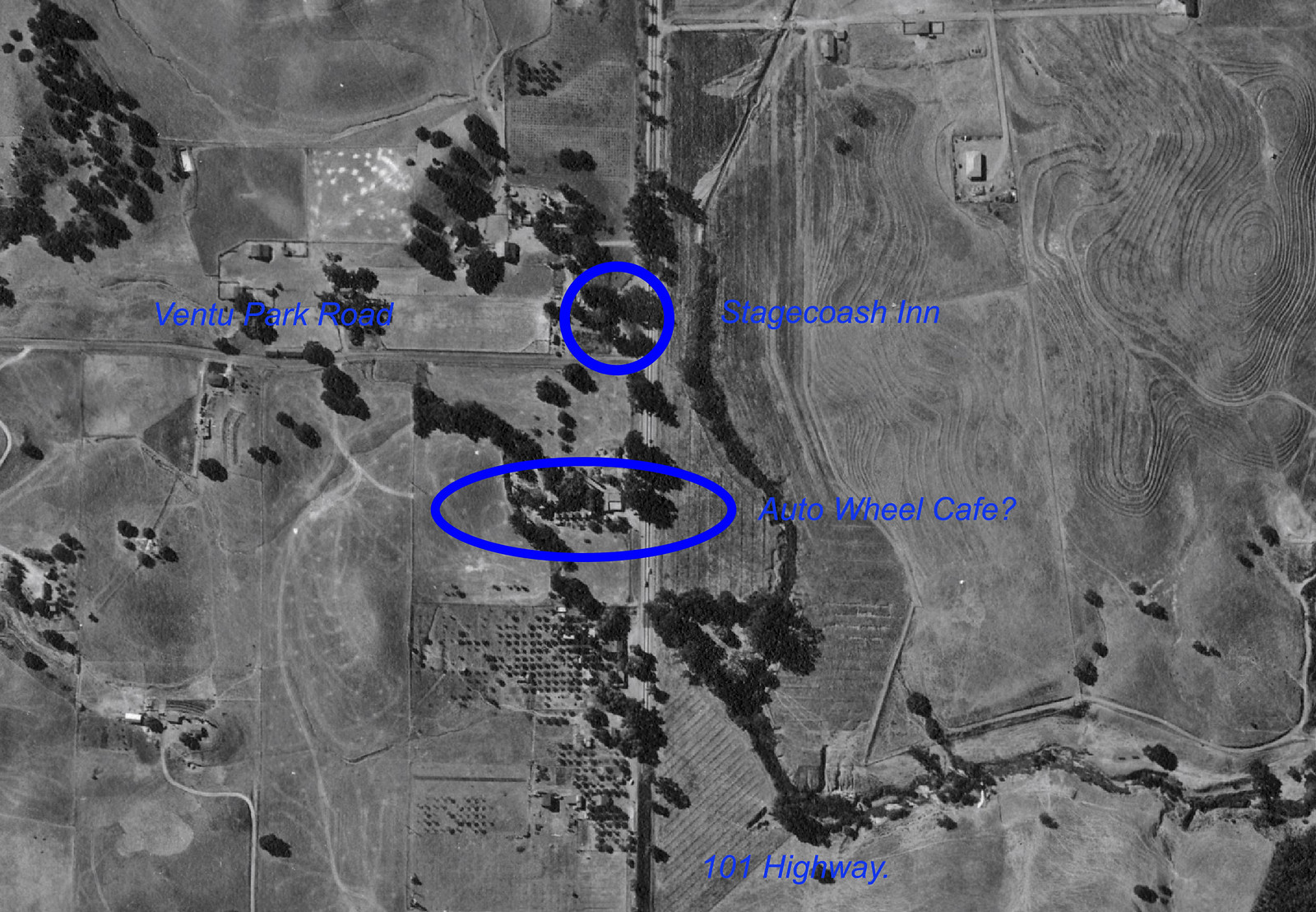
If the business offered gas, food and lodging, as GlendaleBill pondered, it might have appeared on Auto Club "triptik maps of the period.

Uneducated first guess: ~ mid-late '30s auto.


Excerpt from 1913 So Cal Auto Club Map

http://digitallibrary.usc.edu/cdm/si...9coll59/id/339


Conejo Photo Album >> https://www.flickr.com/photos/48427568@N06/


https://i.pinimg.com/474x/27/55/5e/2...k-thursday.jpg


HWY 101 and Moorpark Rd., ~'62
https://i.pinimg.com/736x/61/09/06/6...odel-homes.jpg


Goebels Lion Park (present day - 2100 Thousand Oaks Blvd ?)
https://c1.staticflickr.com/8/7368/9...84ac41cf49.jpg

https://web.archive.org/web/20120606...nd_exhibit.htm

Jungleland went through several iterations but started out as Goebel's African Lion Park
https://web.archive.org/web/20120309...landMap-LG.gif


http://tessa.lapl.org/cdm/singleitem...hotos/id/59245


Food for thought.

1937 Chevrolet
https://cdn1.mecum.com/auctions/sc05...?1337523683000

Last edited by Tourmaline; Aug 25, 2018 at 7:26 PM.
Reply With Quote
     
     
  #48499  
Old Posted Aug 25, 2018, 8:09 PM
ethereal_reality's Avatar
ethereal_reality ethereal_reality is offline
Registered User
 
Join Date: Feb 2008
Location: Lafayette/West Lafayette IN, Purdue U.
Posts: 16,344
'mystery' vantage point.

I've been trying to figure out where the photographer was standing when he/she took this slide back in 1967

"Amateur 35mm Original Slide 1967, Los Angeles Night Scene"


EBAY / no longer listed

As most of you know, the spectacular building on the right is the 17-story Dept. of Water and Power General Offices at 111 N. Hope Street. (it had opened two years prior to when this pic was taken)


Here's a closer look at the buildings down below...and closest...to the roof top where the photographer was standing.


DETAIL

the bldgs are middle left in the top pic (just left of the big D in Debi)

__
Reply With Quote
     
     
  #48500  
Old Posted Aug 25, 2018, 8:25 PM
odinthor's Avatar
odinthor odinthor is offline
Registered User
 
Join Date: May 2015
Posts: 1,323
I thought the cover of the current Calendar publication for the Huntington Library might be of interest. 618 S. Spring Street, the Los Angeles Stock Exchange Building facade, 1929, Samuel E. Lunden (artist of image, Roger Hayward).


Cover, Calendar, Huntington Library, September-October, 2018.

And I assume the cops are standing by to issue jaywalking tickets to the scofflaws pictured.
Reply With Quote
     
     
This discussion thread continues

Use the page links to the lower-right to go to the next page for additional posts

Reply

Go Back   SkyscraperPage Forum > Photography Forums > Found City Photos
Forum Jump


Thread Tools
Display Modes

Forum Jump


All times are GMT. The time now is 8:38 PM.

     
SkyscraperPage.com - Archive - Privacy Statement - Top

Powered by vBulletin® Version 3.8.7
Copyright ©2000 - 2024, vBulletin Solutions, Inc.