HomeDiagramsDatabaseMapsForum About
     

Go Back   SkyscraperPage Forum > Photography Forums > Found City Photos

Reply

 
Thread Tools Display Modes
     
     
  #20561  
Old Posted Mar 29, 2014, 1:42 AM
Tourmaline Tourmaline is offline
Registered User
 
Join Date: May 2012
Posts: 996
Quote:
Originally Posted by MartinTurnbull View Post
Do we know when "Googies" became "Pippys"?


Sorry, I do not know the answer to your question. Checking the '56 CD, the 8100 Sunset address and H0 2-3411 are both shared by Googie's and Sherry's Cocktail Bar. I haven't seen any later listing for Pippy's, but there is some evidence it was there in the mid-late '70s. (Is that a '70s Cadillac Seville?) Access to earlier listings or paper archives might be helpful. For some reasons I recall reading another name may have graced that location but I can't presently verify.

Googies presentation seemed to be well thought out. Pippy's seems to have been a mishmash of competing signage.


A better image that JD would recognize. Probably from the '50s. Notice second sign: "Googies Coffee Shop."
https://scontent-b.xx.fbcdn.net/hpho..._2530477_n.jpg
Reply With Quote
     
     
  #20562  
Old Posted Mar 29, 2014, 5:17 AM
Those Who Squirm!'s Avatar
Those Who Squirm! Those Who Squirm! is offline
Registered User
 
Join Date: Jan 2011
Location: In my specially built chair
Posts: 376
Beverly Gardens Pond

Quote:
Originally Posted by Those Who Squirm View Post
Well, now, this is good news! I'll have to take a drive over there when it's done.
I made it over there today and here are a couple of photos:

General view of the pond


(Own Work)


A shot of just those soothing ripples--now the wallpaper for all my devices!


(Own work)
__________________
The new Wandering In L.A. post is published!

This Is Probably The Oldest Intact School Building In L.A.
Reply With Quote
     
     
  #20563  
Old Posted Mar 29, 2014, 1:50 PM
CityBoyDoug CityBoyDoug is offline
BANNED
 
Join Date: Apr 2013
Posts: 2,868
Mgm

Quote:
Originally Posted by CityBoyDoug View Post
This is one of Walt Disney's several offices....There was one on display at Disneyland a few years ago. Many of the really wonderful displays that were at Disneyland are long gone.

Below is the office of MGM Studio boss.......Louis B. Mayer
Born Lazar Meir, possibly on July 12, 1884, to a Jewish family in Minsk, Russia.

Mayer lived on Saint Cloud Road in the East Gate Bel Air section of Los Angeles, California.

The desk was made in the studio prop department.


MGM
Reply With Quote
     
     
  #20564  
Old Posted Mar 29, 2014, 2:02 PM
GaylordWilshire's Avatar
GaylordWilshire GaylordWilshire is offline
Registered User
 
Join Date: Nov 2009
Location: NYC
Posts: 3,703
UPDATE: A history of the houses is here


A great house rediscovered... posts of Tourmaline and BifRayRock (see post #20498) led me to an interesting place once at 317 S. Vermont:


Zooming in on the center right of the panorama above of Vermont Avenue near 4th revealed the house below...


Seems it was built between 1911 and 1914 by John N. Kirkland, secretary-treasurer of the American Drug Co., at a time when Vermont in this vicinity was a narrower residential street not yet slated to become a major north-south arterial road. (A lot of builders of big houses in the Wilshire District suffered from this kind of bad timing.) While the Kirkland family seems to have owned the house as late as 1928, they appear to have leased it for a few years beginning in 1924 to the Russian Arts Club. I found the pictures below also at the USCDL--the caption info indicates that they were commissioned by Mrs. Kirkland in 1928, perhaps to record the house for posterity (which it now seems she has). I haven't yet looked into how long the house actually stood.


Perhaps that is Mrs. Kirkland on the stoop in the top picture...


All from USCDL

Last edited by GaylordWilshire; Jan 31, 2022 at 11:07 AM.
Reply With Quote
     
     
  #20565  
Old Posted Mar 29, 2014, 3:21 PM
Tourmaline Tourmaline is offline
Registered User
 
Join Date: May 2012
Posts: 996
Quote:
Originally Posted by GaylordWilshire View Post
A great house rediscovered... posts of Tourmaline and BifRayRock (see post #20498) led me to an interesting place once at 317 S. Vermont:


Zooming in on the center right of the panorama above of Vermont Avenue near 4th revealed the house below...


Seems it was built between 1911 and 1914 by John N. Kirkland, secretary-treasurer of the American Drug Co., at a time when Vermont in this vicinity was a narrower residential street not yet slated to become a major north-south arterial road. (A lot of builders of big houses in the Wilshire District suffered from this kind of bad timing.) While the Kirkland family seems to have owned the house as late as 1928, they appear to have leased it for a few years beginning in 1924 to the Russian Arts Club. I found the pictures below also at the USCDL--the caption info indicates that they were commissioned by Mrs. Kirkland in 1928, perhaps to record the house for posterity (which it now seems she has). I haven't yet looked into how long the house actually stood.


Perhaps that is Mrs. Kirkland on the stoop in the top picture...


All from USCDL
A welcome find. There is much going on in the panoramic photo. My first reaction to the house was the designer clearly liked pigeons or the their cooing sounds outside of the upper story windows. Is roof covered in heavy tar paper or could it be sheet metal?

Have noticed garden pictures from a Russian Art Center, circa '15, but doubt they have any relations to this property.

Curious about the large structures behind the house, including what seems to be a mansard roof.


Roofing work.


Wondered about the object to the right of the realty sign. Was it a shrub, an animate object or possibly a well head?


Last edited by Tourmaline; Mar 29, 2014 at 4:24 PM.
Reply With Quote
     
     
  #20566  
Old Posted Mar 29, 2014, 3:30 PM
Tourmaline Tourmaline is offline
Registered User
 
Join Date: May 2012
Posts: 996
Quote:
Originally Posted by Godzilla View Post
Resisted posting these in attempt to avoid reposts. Search does not provide an immediate answer.


Strange street markings, that were probably short lived. Effectiveness of middle of the road traffic warnings (potential cross traffic) seems questionable. Arrow points to . . . ? [Bang*]

1929 Wilshire and Ardmore.
http://jpg1.lapl.org/pics19/00009340.jpg


1940
http://jpg3.lapl.org/pics51/00075430.jpg


1966
http://jpg1.lapl.org/00104/00104488.jpg


1970 - Wilshire Corridor
http://jpg3.lapl.org/pics37/00068485.jpg


Opposing view - late '40s early '50s (?)
http://jpg1.lapl.org/pics19/00009318.jpg

Add to the list

Mid to late '80s. Concrete jungle.
http://catalog.library.ca.gov/exlibr...B3831TGM1X.jpg
Reply With Quote
     
     
  #20567  
Old Posted Mar 29, 2014, 6:02 PM
GaylordWilshire's Avatar
GaylordWilshire GaylordWilshire is offline
Registered User
 
Join Date: Nov 2009
Location: NYC
Posts: 3,703
Quote:
Originally Posted by Tourmaline View Post

A welcome find. There is much going on in the panoramic photo. My first reaction to the house was the designer clearly liked pigeons or the their cooing sounds outside of the upper story windows. Is roof covered in heavy tar paper or could it be sheet metal?

Have noticed garden pictures from a Russian Art Center, circa '15, but doubt they have any relations to this property.

Curious about the large structures behind the house, including what seems to be a mansard roof.

I don't know about the pigeons or the lawn item or the roofing material, but the mansard-roofed building is 275 S New Hampshire:


GSV

In the aerial, 275 SNH is at top left; 317 S Vt was about where the McDonald's parking lot is at lower right.


A little noir:

LAT April 3, 1935
Reply With Quote
     
     
  #20568  
Old Posted Mar 29, 2014, 6:56 PM
HossC's Avatar
HossC HossC is offline
Registered User
 
Join Date: Aug 2013
Posts: 4,245
Quote:
Originally Posted by Tourmaline View Post
If those pics pique anyone's interest, could someone find a way of posting a complete enlarged high resolution version of the related panorama (below)? Previous effort did not do it justice! (post 13540)

Incomplete low resolution version:
I'm not sure if anyone ever posted a larger version of the panorama. Obviously the one below doesn't come close to the zoom levels of the recent detail posts by GaylordWilshire and Tourmaline, but it's already over 4000 pixels wide.

NB. I've spent a while trying to reduce the differences in lightness between panels and also made a few other tweaks.


USC Digital Library

I was interested to know what the roof sign near the top right corner of the bulding on left said. Zooming in, it was easy to see that it was the still extant sign atop the Du Barry apartments at the corner of Catalina and 5th.


Detail of picture above.

More pictures of the Du Barry apartments can be found in e_r's post here.
Reply With Quote
     
     
  #20569  
Old Posted Mar 29, 2014, 7:40 PM
Tourmaline Tourmaline is offline
Registered User
 
Join Date: May 2012
Posts: 996
Quote:
Originally Posted by Tourmaline View Post


"There it is. Take it."
http://content.cdlib.org/ark:/13030/tf4489p2f2/hi-res


1938 - Terminal Island - docked fishing boats, Van Camp Seafood Co. and the French Sardine Co.
http://jpg1.lapl.org/00100/00100895.jpg


Aug. '74 Starkist Terminal Island had 1000 female employees. (Shut down by '85)
Read more here: http://framework.latimes.com/2013/07...000-employees/

http://latimesphoto.files.wordpress....ttunaxz970.jpg
Reply With Quote
     
     
  #20570  
Old Posted Mar 29, 2014, 7:44 PM
Tourmaline Tourmaline is offline
Registered User
 
Join Date: May 2012
Posts: 996
BRAVO! HossC


Quote:
Originally Posted by Martin Pal View Post
LAPL

The Monkey Island stop?
http://www.uncanny.net/~wetzel/barham.JPG

Last edited by Tourmaline; Mar 30, 2014 at 1:03 AM.
Reply With Quote
     
     
  #20571  
Old Posted Mar 29, 2014, 8:00 PM
Tourmaline Tourmaline is offline
Registered User
 
Join Date: May 2012
Posts: 996
Quote:
Originally Posted by HossC View Post

Wondering what was to the east of Vermont i.e., toward the far right of the photo. The area has a chain link demarcating something. Ground looks like it was torn up and far from natural state. There is a large lamp mounted on a post. I took this to serve as billboard illumination, but maybe it was for something much bigger. Doesn't resemble typical landfill. Another golf course or an amusement park? Thinking it may have been some enterprise that the Kirklands would not have considered a nuisance.
Reply With Quote
     
     
  #20572  
Old Posted Mar 29, 2014, 8:29 PM
WCArch WCArch is offline
Registered User
 
Join Date: Jan 2014
Posts: 42
__________________
This is an awesome Architecture blog: www.westcoastarch.blogspot.com
Reply With Quote
     
     
  #20573  
Old Posted Mar 29, 2014, 9:56 PM
HossC's Avatar
HossC HossC is offline
Registered User
 
Join Date: Aug 2013
Posts: 4,245
With reference to the Vermont panorama above, one of the few survivors on that section of Vermont Avenue is the building on the corner of 3rd.
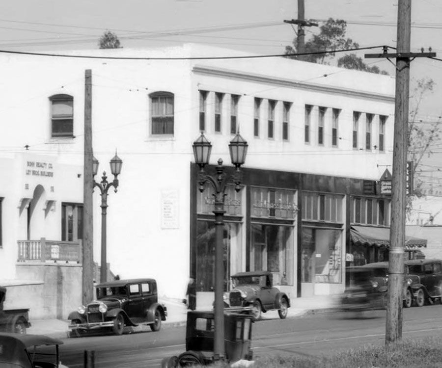

Detail of panorama above.

The modern signage does little to accentuate the building, but otherwise it looks intact.
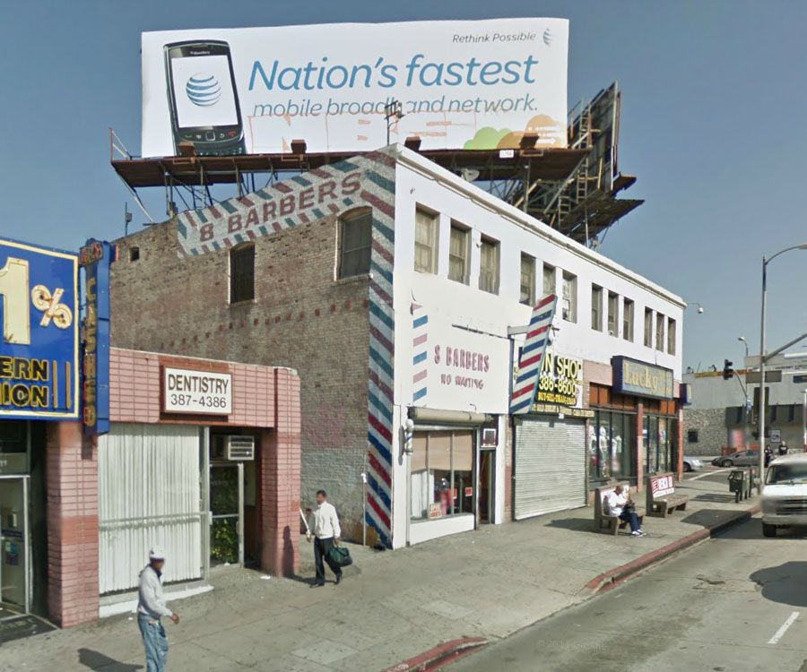

GSV

The current view looking west on 4th Street shows that the Park Lane Apartments (3333 W 4th St) and the church on the west side of New Hampshire are still standing. The church still looks beautiful, although I'll wager that it wasn't the Korean Philadelphia Presbyterian Church when the panorama was taken!
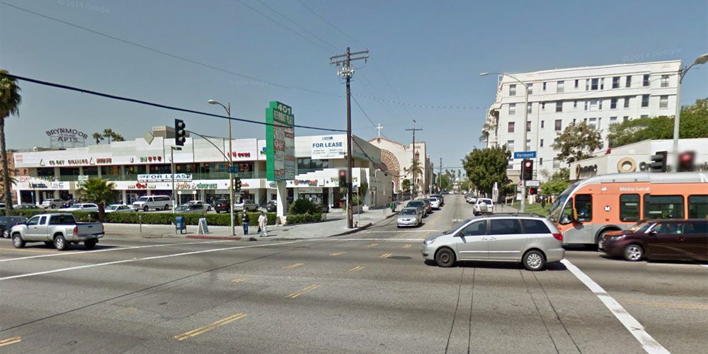

GSV

On the left of the view above is another roof sign. By chance, I found a postcard of the Brynmoor Apartments on Ebay a few weeks ago, and didn't even know it had a roof sign.


Ebay

The roof sign is at the back, so was obviously meant to be seen from Vermont and 4th.


Google Maps

Other than the windows being changed, the wall and arched sign at the entrance seem to be the only alterations from the postcard.
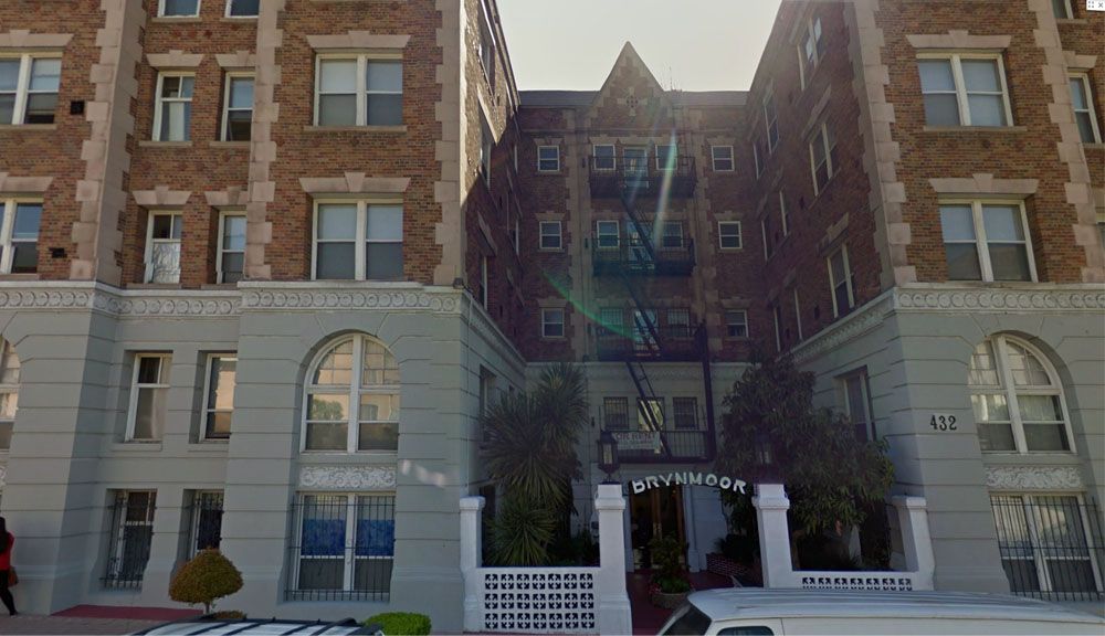

GSV
Reply With Quote
     
     
  #20574  
Old Posted Mar 30, 2014, 12:24 AM
GaylordWilshire's Avatar
GaylordWilshire GaylordWilshire is offline
Registered User
 
Join Date: Nov 2009
Location: NYC
Posts: 3,703


Another Green Lantern Fountain...


Quote:
Originally Posted by ethereal_reality View Post
originally posted by HossC


I can't let this amazing detail of 5000 S. Central Ave. pass without pointing out the Green Lantern Fountain sign at upper right.
It immediately brought back memories of having 'Green Rivers' at the one and only drug store in my hometown.
After all these years looking at vintage photographs I've never noticed a sign such as this.
__

See also post #18453.
Reply With Quote
     
     
  #20575  
Old Posted Mar 30, 2014, 12:50 AM
Flyingwedge's Avatar
Flyingwedge Flyingwedge is offline
Registered User
 
Join Date: Jun 2012
Location: Los Angeles
Posts: 1,127
Quote:
Originally Posted by HossC View Post
Quote:
Originally Posted by Tourmaline View Post
Wondering what was to the east of Vermont i.e., toward the far right of the photo. The area has a chain link demarcating something. Ground looks like it was torn up and far from natural state. There is a large lamp mounted on a post. I took this to serve as billboard illumination, but maybe it was for something much bigger. Doesn't resemble typical landfill. Another golf course or an amusement park? Thinking it may have been some enterprise that the Kirklands would not have considered a nuisance.
The right side of the photo may show the aftermath of the undergrounding of Sacatela Creek. The light may be left over from that work. Perhaps it was used to illuminate
the area under Vermont at 4th, as it seems to be pointing in that direction.

I touched on Sacatela's undergrounding in this post on nearby Diana Street: http://forum.skyscraperpage.com/show...ostcount=12318
Reply With Quote
     
     
  #20576  
Old Posted Mar 30, 2014, 1:34 AM
Tourmaline Tourmaline is offline
Registered User
 
Join Date: May 2012
Posts: 996
Quote:
Originally Posted by Flyingwedge View Post
The right side of the photo may show the aftermath of the undergrounding of Sacatela Creek. The light may be left over from that work. Perhaps it was used to illuminate
the area under Vermont at 4th, as it seems to be pointing in that direction.
Should have connected the dots and the sloughs.

With this information I would now presume that when the Kirkland home was built, it essentially fronted a marsh or wetland. Curious if the creek was used as a water source for the home and nearby businesses. I recall some mention that the Fire station on Western was said to have tapped nearby springs and I haven't noticed any hydrants in the photo. It was one of the first choices regarding the lawn object next door to the Kirkland house.

Could this area have ever been improved? I don't recall any prior improvements, but the chain and posts seems somewhat more then a temporary barrier during construction. Could the chain have cordoned off an area being used as some sort of public facility? Another Bimini Slough? Or perhaps it was just a means of controlling access to the neighborhood quicksand.

It occurs to me that the Kirkland house and general vicinity has been seen before - but at night. http://digitallibrary.usc.edu/cdm/co...id/17856/rec/2

http://skyscraperpage.com/forum/show...ostcount=16921


More of those mysterious posts and chain:


Last edited by Tourmaline; Mar 30, 2014 at 2:09 AM.
Reply With Quote
     
     
  #20577  
Old Posted Mar 30, 2014, 1:42 AM
HossC's Avatar
HossC HossC is offline
Registered User
 
Join Date: Aug 2013
Posts: 4,245
I found this "then and now" montage of 4th and Vermont at urban diachrony. It looks like there was a large pile of dirt where the golf course is in the panorama. The upper picture is available for zooming at the USC Digital Library.


urbandiachrony
Reply With Quote
     
     
  #20578  
Old Posted Mar 30, 2014, 12:11 PM
HossC's Avatar
HossC HossC is offline
Registered User
 
Join Date: Aug 2013
Posts: 4,245
I think this picture may have been posted on NLA before. It's taken from 4th, looking south on Vermont, and possibly shows the aftermath of the undergrounding of Sacatela Creek mentioned above by Flyingwedge. USC date it at 1931.


USC Digital Library

Off in the distance are The Talmadge and the Presbyterian church on Wilshire.


Detail of picture above.
Reply With Quote
     
     
  #20579  
Old Posted Mar 30, 2014, 1:18 PM
GaylordWilshire's Avatar
GaylordWilshire GaylordWilshire is offline
Registered User
 
Join Date: Nov 2009
Location: NYC
Posts: 3,703
USCDL/HLA


The Kirklands' piece of paradise, once at 317 S. Vermont--is now a McDonald's parking lot. But it lasted longer than you might think, apparently well beyond Mrs. Kirkland's death in 1955. Here's a little more: http://losangeleshistory.blogspot.co...ease-also.html


LAPL/Historic Aerials


1929 and 1954 aerials with 317 S. Vermont circled in red; in 1929, a year before the slough was covered, West 3rd had yet to be cut through to the east.

Night shots, Vermont between 4th and 3rd, 1931:


West 3rd St. looking west from Westmoreland, 1938; the Kirkland house is at far left:


A few more pics of Vermont and 3rd-- note 275 S. New Hampshire in the top shot and Artie Shaw at the Palomar in the second.


All LAPL

Last edited by GaylordWilshire; Feb 8, 2018 at 10:59 PM.
Reply With Quote
     
     
  #20580  
Old Posted Mar 30, 2014, 2:05 PM
HossC's Avatar
HossC HossC is offline
Registered User
 
Join Date: Aug 2013
Posts: 4,245
Quote:
Originally Posted by Tourmaline View Post
I found this shot taken from Barham Boulevard. It's also looking north, and appears to show the same streetcar. The caption says "Pacific Electric Railway streetcar no.5179 on the Van Nuys Line heading south at Barham Boulevard. November 15, 1952". Whatever was left of Monkey Island would have been on the left near the billboards.


Metro Library and Archive

Before the freeway: the junction of Barham and Cahuenga.
NB. This is a small section of a 1939 aerial originally posted by MichaelRyerson. I've rotated it to match the other aerials below.


Detail of image in USC Digital Library

In 1948, the streetcar tracks and stairs are visible under Barham Boulevard. The freeway is still under construction and curves onto Cahuenga just south of Monkey Island.


Obviously the streetcar tracks went long before this 1980 aerial, but the views from the '70s were blurrier.


This 2004 aerial shows roughly how the area looks today.


The last three images are from Historic Aerials.
Reply With Quote
     
     
This discussion thread continues

Use the page links to the lower-right to go to the next page for additional posts

Reply

Go Back   SkyscraperPage Forum > Photography Forums > Found City Photos
Forum Jump


Forum Jump


All times are GMT. The time now is 9:39 AM.

     
SkyscraperPage.com - Archive - Privacy Statement - Top

Powered by vBulletin® Version 3.8.7
Copyright ©2000 - 2024, vBulletin Solutions, Inc.