HomeDiagramsDatabaseMapsForum About
     

Go Back   SkyscraperPage Forum > Regional Sections > Canada > Ontario > Hamilton > General Discussion


Reply

 
Thread Tools Display Modes
     
     
  #61  
Old Posted Jun 25, 2013, 10:41 AM
Dr Awesomesauce's Avatar
Dr Awesomesauce Dr Awesomesauce is offline
Registered User
 
Join Date: Jan 2010
Location: BEYOND THE OUTER RIM
Posts: 5,889
Another beauty. Can you identify the buildings and roads featured in this photo?


source
Reply With Quote
     
     
  #62  
Old Posted Jun 25, 2013, 12:19 PM
mattgrande's Avatar
mattgrande mattgrande is offline
Registered User
 
Join Date: Jul 2010
Location: Hamilton
Posts: 1,240
Well that's clearly an incline rail station on the right. There appears to be a road heading down the escarpment, so I'm going to say that's Upper James Street, and the road on the right is the precursor to the Claremont Access.

The building on the left I've seen before... A picture from the front, looking up... I think it was a hotel, although the name esacpes me.
__________________
Livin' At The Corner Of Dude And Catastrophe.
Reply With Quote
     
     
  #63  
Old Posted Jun 25, 2013, 12:30 PM
thistleclub thistleclub is offline
Registered User
 
Join Date: Mar 2008
Posts: 3,728
The Mountain View Hotel, formerly at the top of the Claremont Access. Upper James is the left hand turn, West 5th (or would that have been an unredacted Claremont Drive?) straight ahead. Now Southam Park. Brian Henley writes: "The street heading west was Claremont, while the roadway seen at the bottom is the top of Strongman’s Road, turning to the left into what is now Upper James Street."

Originally part of Hon. Isaac Buchanan's expansive Claremont estate, which gave the roads their name. The western approach was marked by Claremont Lodge, the northern edge by Auchmar at West 5th and Fennell.

Haunted Hamilton suggests that the Cafe Palazzo building about 1/2km east of Auchmar was also once part of the Clairmont holding.

The building at right is apparently a station of the Hamilton and Barton Incline Railway, the city's first incline railway.
__________________
"Where architectural imagination is absent, the case is hopeless." - Louis Sullivan

Last edited by thistleclub; Jun 25, 2013 at 1:24 PM.
Reply With Quote
     
     
  #64  
Old Posted Jun 26, 2013, 12:36 AM
palace1 palace1 is offline
Registered User
 
Join Date: May 2008
Posts: 221
Quote:
Originally Posted by thistleclub View Post
Haunted Hamilton suggests that the Cafe Palazzo building about 1/2km east of Auchmar was also once part of the Clairmont holding.
Haunted Hamilton is incorrect when they state the Café Palazzo building was "originally one of the buildings of the Auchmar estate."

The building was built by Barton Township to house the Township Hall on the second floor with two storefronts on the first floor.
The book "Mountain Memories" has a photo from 1915 showing it housing the Giles Grocery Store (the family lived in one storefront and operated the store from the other). The book says "There is no date for its construction but it is likely to have been a year or two before these photos were taken."

From 1919-1986 it housed the Buchanan Lodge of Freemasonry (they purchased it from Barton Township in 1929).
http://www.hamiltondistrictcmasons.o...php?lodge_id=8
Reply With Quote
     
     
  #65  
Old Posted Jun 26, 2013, 1:25 AM
Dr Awesomesauce's Avatar
Dr Awesomesauce Dr Awesomesauce is offline
Registered User
 
Join Date: Jan 2010
Location: BEYOND THE OUTER RIM
Posts: 5,889
Some great details there. Cheers.


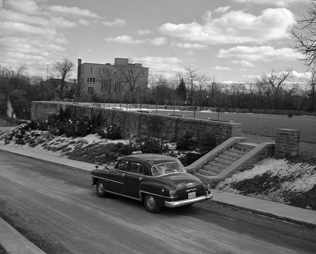
Post-demolition: Southam Park


And yes, the road climbing the Mountain was known as Strongman's Road or in some cases The Strongman Road. I'm not entirely sure where it ran from, though I think it was an extension of John Street. In fact, I've read that it's still there under the Claremont Access; some of us have likely hiked along this road/ trail and not even known it (Perhaps it's a spur of the Bruce Trail). I've also seen pictures where it intersects with the Jolley Cut but I don't know where that intersection was. I think this was its course:


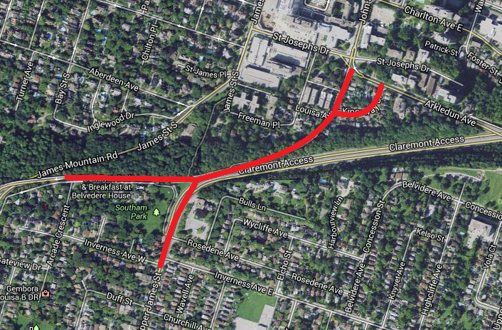
I'm not sure whether it led directly from John or perhaps from Arkledun via Kingsway Drive.

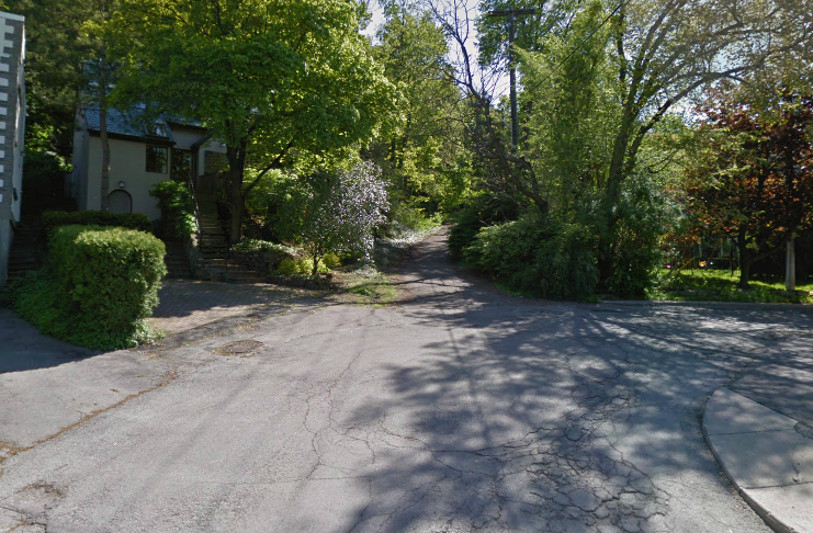
I think this is Strongman Road disappearing into the forest.


Here's a view of the 'Hair Pin Turn' where Strongman Road branched off from the Jolley Cut. Strongman leads away from the shot and the Jolley Cut continues up behind where the photo was taken.


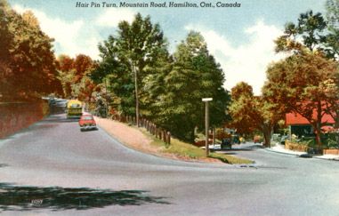
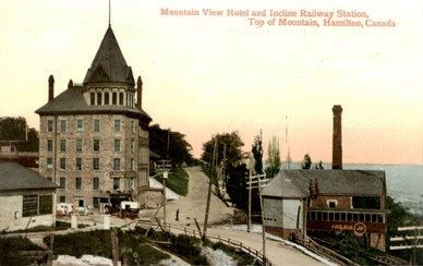
This confuses the hell outta me. I think this must be a later incarnation of the road completed after the Jolley Cut was built and farther up towards where 'the Cut' now passes over the Claremont. The red-roofed building is probably 'the castle' (Colour was added to make the postcard more attractive, I suppose).

Anyway, Strongman Road looks like it was a very steep and treacherous way to get up and down the Mountain. I think it's time to head back up there and have a look around - it's been a few years.

source i
source ii

Last edited by Dr Awesomesauce; Jun 26, 2013 at 1:35 AM.
Reply With Quote
     
     
  #66  
Old Posted Jun 26, 2013, 7:01 AM
bigguy1231 bigguy1231 is offline
Concerned Citizen
 
Join Date: Mar 2009
Location: Hamilton
Posts: 1,336
I remember going up that road as a young child and it wasn't any steeper than the current James St. access.

When they built the current Clairmont access and Jolly cut they cut out a huge chunk of the escarpment which makes visualizing what was there difficult. The old road towards Upper James didn't begin until almost halfway up the current Jolley cut where the old toll house still stands just before the bridge over the Clairmont. Thats the last house on the left heading upbound.
Reply With Quote
     
     
  #67  
Old Posted Jun 26, 2013, 1:52 PM
Dr Awesomesauce's Avatar
Dr Awesomesauce Dr Awesomesauce is offline
Registered User
 
Join Date: Jan 2010
Location: BEYOND THE OUTER RIM
Posts: 5,889
^Thanks for that. Yeah, it's shocking how much of the escarpment's been chipped away at over the decades and that's part of what makes visualizing the course of Strongman's Road so difficult. I do think the first incarnation extended from John and that they later re-routed it to link up with the Jolley Cut but I'll have to confirm that with an expert.
Reply With Quote
     
     
  #68  
Old Posted Jun 27, 2013, 2:57 PM
bigguy1231 bigguy1231 is offline
Concerned Citizen
 
Join Date: Mar 2009
Location: Hamilton
Posts: 1,336
Quote:
Originally Posted by pEte fiSt iN Ur fAce View Post
^Thanks for that. Yeah, it's shocking how much of the escarpment's been chipped away at over the decades and that's part of what makes visualizing the course of Strongman's Road so difficult. I do think the first incarnation extended from John and that they later re-routed it to link up with the Jolley Cut but I'll have to confirm that with an expert.
From what I remember about my Hamilton history that road never went directly down to John St. It turned back to John just like in the picture. From the historical maps that I have been looking at as early as 1875 the road always showed a cut back along Arkledun. It was a toll road at one time and the toll house is still there.
Reply With Quote
     
     
  #69  
Old Posted Jun 28, 2013, 1:11 AM
Dr Awesomesauce's Avatar
Dr Awesomesauce Dr Awesomesauce is offline
Registered User
 
Join Date: Jan 2010
Location: BEYOND THE OUTER RIM
Posts: 5,889
This must be the toll house then, yeah? Cool.

source
Reply With Quote
     
     
  #70  
Old Posted Jun 28, 2013, 1:26 AM
Dr Awesomesauce's Avatar
Dr Awesomesauce Dr Awesomesauce is offline
Registered User
 
Join Date: Jan 2010
Location: BEYOND THE OUTER RIM
Posts: 5,889
One last reference to Strongman Road. You can see it here in the foreground ca. 1859.

source
Reply With Quote
     
     
  #71  
Old Posted Jun 28, 2013, 10:55 PM
bigguy1231 bigguy1231 is offline
Concerned Citizen
 
Join Date: Mar 2009
Location: Hamilton
Posts: 1,336
Quote:
Originally Posted by pEte fiSt iN Ur fAce View Post
This must be the toll house then, yeah? Cool.

source
No, it's the older stone building across the street.
Reply With Quote
     
     
  #72  
Old Posted Jun 29, 2013, 1:18 AM
ScreamingViking's Avatar
ScreamingViking ScreamingViking is offline
Ham-burgher
 
Join Date: Jun 2013
Location: Hamilton
Posts: 6,521
Quote:
Originally Posted by pEte fiSt iN Ur fAce View Post
I do think the first incarnation extended from John and that they later re-routed it to link up with the Jolley Cut but I'll have to confirm that with an expert.
I wouldn't be surprised if you could find some old maps at Lloyd Reeds
http://library.mcmaster.ca/maps/

(great thread topic, by the way )
Reply With Quote
     
     
  #73  
Old Posted Jun 29, 2013, 3:05 AM
Dr Awesomesauce's Avatar
Dr Awesomesauce Dr Awesomesauce is offline
Registered User
 
Join Date: Jan 2010
Location: BEYOND THE OUTER RIM
Posts: 5,889
Yeah, Mac has a tonne don't they. But I'm not sure any of them are digitised and if they are, it's probably a pain getting your hands on them. Even a million years after leaving university, I don't think navigating the library has got any easier. I've got a headache just thinking about it. I prefer the Central Library - much easier access.
Reply With Quote
     
     
  #74  
Old Posted Jun 30, 2013, 3:07 AM
Dr Awesomesauce's Avatar
Dr Awesomesauce Dr Awesomesauce is offline
Registered User
 
Join Date: Jan 2010
Location: BEYOND THE OUTER RIM
Posts: 5,889


From right to left:
i) George Hamilton's residence
ii) Church of the Ascension
iii) Central School
iv) Sandyford Place
v) Crystal Palace (Victoria Park)

I wonder if Mr Hamilton liked having traffic - not whizzing - but rattling and clip-clopping its way past his home morning, noon and night. Perhaps he was an early proponent of traffic calming measures and complete streets. We'll never know. Actually, I'm pretty sure he was long dead by 1859 but his relations may have taken issue with it.
Reply With Quote
     
     
  #75  
Old Posted Jun 30, 2013, 8:33 AM
Dr Awesomesauce's Avatar
Dr Awesomesauce Dr Awesomesauce is offline
Registered User
 
Join Date: Jan 2010
Location: BEYOND THE OUTER RIM
Posts: 5,889
Yeah, that makes more sense. And the toll house does appear to be completely separate from the rest of Rock Castle.

source

Here are some early shots of the Jolley Cut. Notice that it's two lanes and tree lined! Unrecognizable. Not sure if this is going up or coming down. Maybe down.


This looks a bit frightening.


And here it is after it was widened to four lanes. A good view down into Corktown and the old rail yard.

source
Reply With Quote
     
     
  #76  
Old Posted Jun 30, 2013, 2:04 PM
CaptainKirk CaptainKirk is offline
Registered User
 
Join Date: Apr 2011
Posts: 1,449
This is the most awesomest thread ever!

Keep 'em coming!
Reply With Quote
     
     
  #77  
Old Posted Jul 1, 2013, 1:19 AM
Dr Awesomesauce's Avatar
Dr Awesomesauce Dr Awesomesauce is offline
Registered User
 
Join Date: Jan 2010
Location: BEYOND THE OUTER RIM
Posts: 5,889
It's true - it is pretty awesome.

If anybody else wants to contribute to the 'game' please feel free.
Reply With Quote
     
     
  #78  
Old Posted Jul 1, 2013, 1:35 AM
Dr Awesomesauce's Avatar
Dr Awesomesauce Dr Awesomesauce is offline
Registered User
 
Join Date: Jan 2010
Location: BEYOND THE OUTER RIM
Posts: 5,889
Here's my FINAL image of Strongman Road. Based on what I've gleaned from old photos and maps and from what BigGuy mentioned, I believe the original path of the road to have been straight up John St past the Durand/ Hamilton estate and up to what is now Upper James and Claremont. And some time later - not sure when - it was re-routed part way up the Jolley Cut to, amongst other things, allow for a more gradual and pleasant ride up and down the Mountain.


I have not been able to confirm this or not but I still feel that this path at the top of John/ Kingsway follows the original path of Strongman Road.

source
Reply With Quote
     
     
  #79  
Old Posted Jul 1, 2013, 10:41 PM
bigguy1231 bigguy1231 is offline
Concerned Citizen
 
Join Date: Mar 2009
Location: Hamilton
Posts: 1,336
Quote:
Originally Posted by CaptainKirk View Post
This is the most awesomest thread ever!

Keep 'em coming!
I suspect this is where Pete is getting his info. Brian Henley posts all kinds of this on his site. He also has a Facebook page.

http://henleyshamilton1.wordpress.com/
Reply With Quote
     
     
  #80  
Old Posted Jul 1, 2013, 10:52 PM
bigguy1231 bigguy1231 is offline
Concerned Citizen
 
Join Date: Mar 2009
Location: Hamilton
Posts: 1,336
[QUOTE=pEte fiSt iN Ur fAce;6182852]Here's my FINAL image of Strongman Road. Based on what I've gleaned from old photos and maps and from what BigGuy mentioned, I believe the original path of the road to have been straight up John St past the Durand/ Hamilton estate and up to what is now Upper James and Claremont. And some time later - not sure when - it was re-routed part way up the Jolley Cut to, amongst other things, allow for a more gradual and pleasant ride up and down the Mountain.

I have not been able to confirm this or not but I still feel that this path at the top of John/ Kingsway follows the original path of Strongman Road.


The only reason I was thinking that the dirt path wasn't Strongman, is that if you take the stairs from James to Upper James, that dirt path, which used to be visible from the stairs only goes about halfway up the escarpment at the point of the stairs.
Reply With Quote
     
     
This discussion thread continues

Use the page links to the lower-right to go to the next page for additional posts
 
 
Reply

Go Back   SkyscraperPage Forum > Regional Sections > Canada > Ontario > Hamilton > General Discussion
Forum Jump


Forum Jump


All times are GMT. The time now is 8:28 AM.

     
SkyscraperPage.com - Archive - Privacy Statement - Top

Powered by vBulletin® Version 3.8.7
Copyright ©2000 - 2024, vBulletin Solutions, Inc.