Ertland is a fictional country created by me. It is located on the Ionion Sea, between Italy and Greece. The first settlers of Ertland were escaped slaves from Greece. The slaves had their own language, so they could communicate with other slaves without the greek people knowing what they were saying. "Ertland" derived from the original name: Erterun, which means Land of Freedom in the slave's language. In the late 18th century, a group of American explorers came to Erterun. There they taught the settlers english and they changed the name to Ertland. Today only a handful of people can speak the slave's special language fluently, mostly because their ancestors were escaped slaves.
Map of Ertland (I know it's crappy)

Flag of Ertland
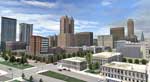
 Avunin City
Avunin city is on the northern coast of Ert Land. It is kinda small compared to other Ertish cities. A river splits the city in half, in the northern tip is a waterfall which leads to the ocean.
Districts:
-Avunin Peninsula, the CBD with the office buildings and stuff
-Kenston, the residential district to the east of Avunin peninsula, including Kenston Beach
-Southern Heights, south east of Kenston, an upper class suburbian area
-Harold, the residential area west of the CBD
-Lansworth, the old town-ish area south west of Harold
-the docks, the industrial area in the western end of the city.
The nickname of Avunin City is Cliff City
Link to 3d Model:
http://sketchup.google.com/3dwarehou...e60e0b8753e48d
Photos


 Ert Cap City
Ert Cap City is the capital city of Ertland. It is located on the eastern coast.
MORE DESCRIPTION AND DISTRICTS SOON
Photos


Older Photos


 Rhykh City
Rhykh City is located on the hills of Inner East Ertland. It is a mid sized city. The river, Rhykh River, seperates the city into two boroughs: West Bank and East Bank. The river flows all the way to Avunin City, and ends with a waterfall.
MORE DESCRIPTION AND DISTRICTS SOON
Photos


 Manoser City
http://forum.skyscraperpage.com/showthread.php?t=166622
Manoser City
http://forum.skyscraperpage.com/showthread.php?t=166622
MORE COMING SOON


 Linear Mode
