HomeDiagramsDatabaseMapsForum About
     

Go Back   SkyscraperPage Forum > Discussion Forums > Transportation


Reply

 
Thread Tools Display Modes
     
     
  #161  
Old Posted Sep 16, 2009, 2:11 PM
Sekkle's Avatar
Sekkle Sekkle is offline
zzzzzzzz
 
Join Date: Aug 2006
Location: Portland area
Posts: 2,276
Quote:
Originally Posted by FoUTASportscaster View Post
Thanks for the help. This is exactly what I was hoping for. I was able to follow the directions to Apache, but can't figure out where it goes from there. The satellite image wasn't helpful, as it was apparently taken before that section was under construction. Can you help?
The line goes straight east on Apache, continues over the 101 freeway, past Dobson Rd and ends at Sycamore (Apache becomes Main somewhere just east of the 101).
__________________
Some photo threads I've done... Portland (2021) | New York (2011) | Seattle (2011) | Phoenix (2010) | Los Angeles (2010)
flickr
Reply With Quote
     
     
  #162  
Old Posted Sep 17, 2009, 12:14 PM
FoUTASportscaster FoUTASportscaster is offline
Registered User
 
Join Date: Aug 2009
Posts: 81
Thank you. Phoenix is now updated and shows the correct route.
Reply With Quote
     
     
  #163  
Old Posted Sep 22, 2009, 6:43 PM
BTinSF BTinSF is offline
BANNED
 
Join Date: Jun 2006
Location: San Francisco & Tucson
Posts: 24,088
The new (almost--no cable cars) all-inclusive Bay Area rail transit map:


Source: http://sfcityscape.com/
Reply With Quote
     
     
  #164  
Old Posted Oct 9, 2009, 2:06 PM
SnyderBock's Avatar
SnyderBock SnyderBock is offline
Robotic Construction
 
Join Date: Sep 2006
Posts: 3,833
Denver System (Current System & Funded Extensions)

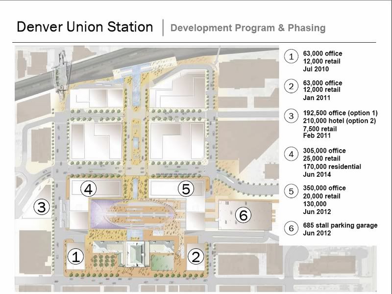
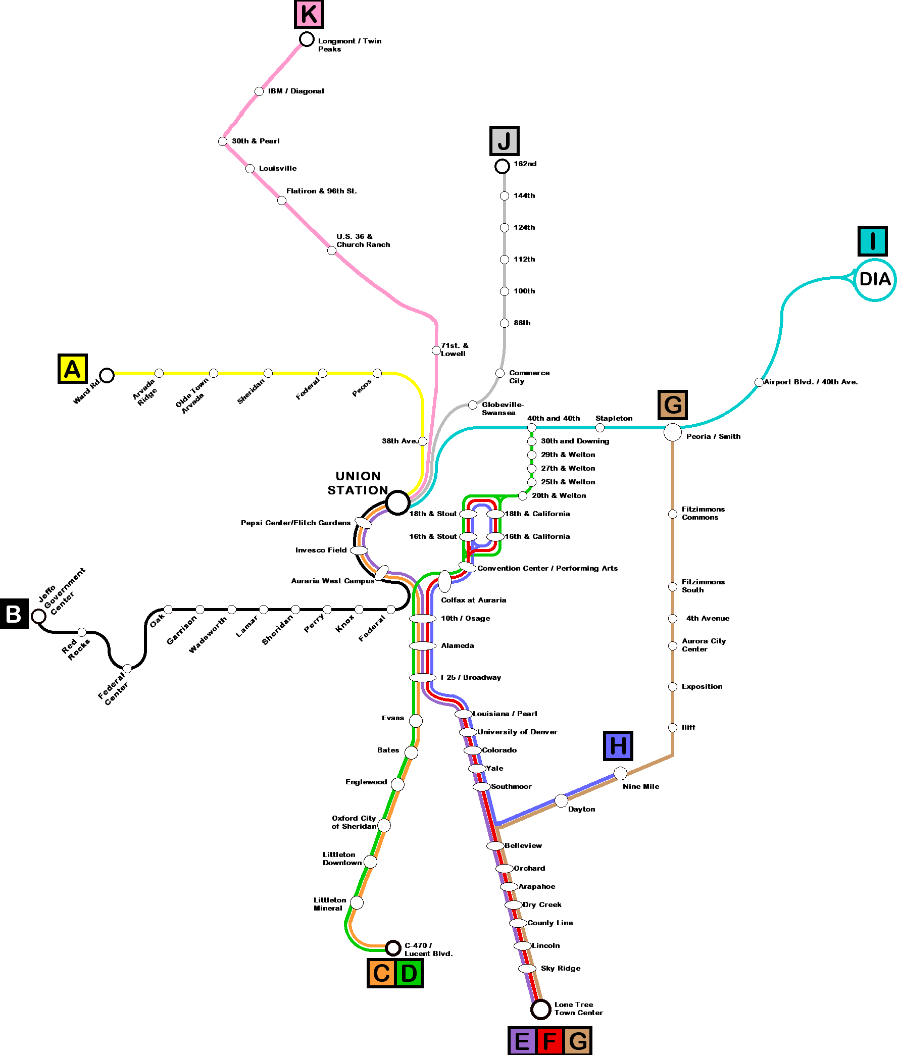
FasTracks will transform Denver Union Station (DUS) into a multi-model transportation hub. This $480 million+ DUS project is part of a larger, $6.1 billion ($7.1 billion after most recent cost estimate) transportation project called FasTracks. FasTracks will construct four new commuter rail lines (2-EMU; 2-DMU), one new Light Rail Line (LRT), and extend three existing LRT lines. It will also include a 38-mile Bus Rapid Transit (BRT) line. The BRT line will have limited access ROW down a medium of a highway and operate just as a rail line. All of this is to be completed & operational by 2017 - making it the nations most ambitious transportation project in recent memory.

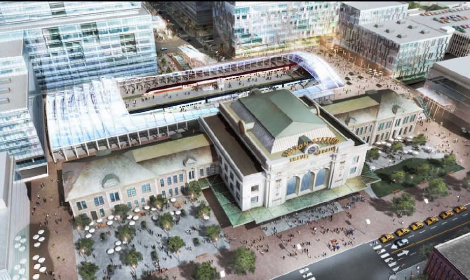
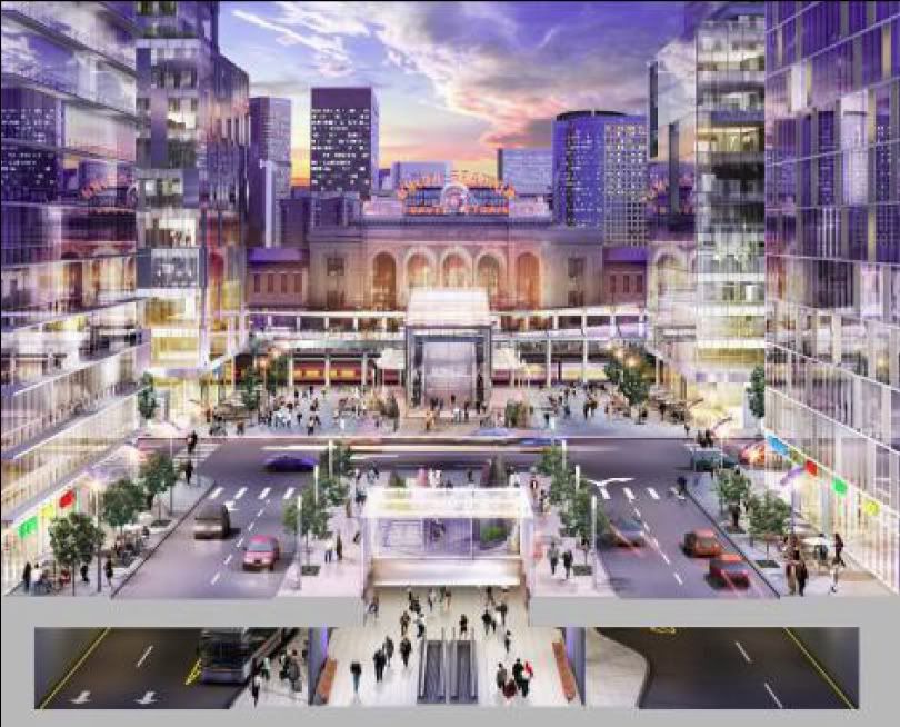
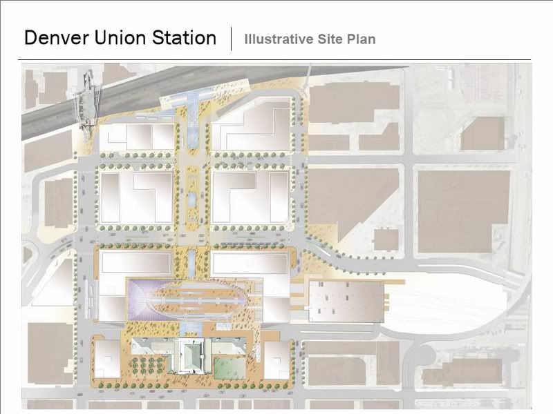
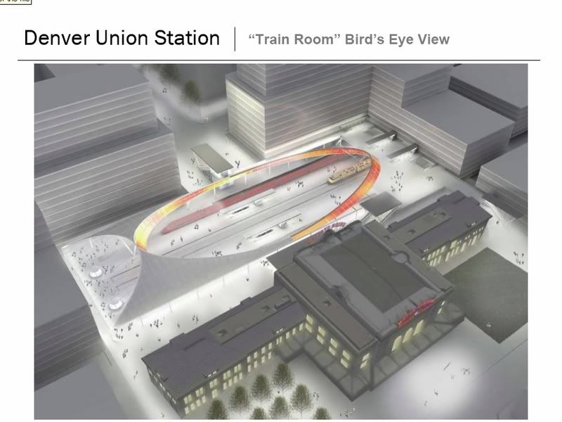
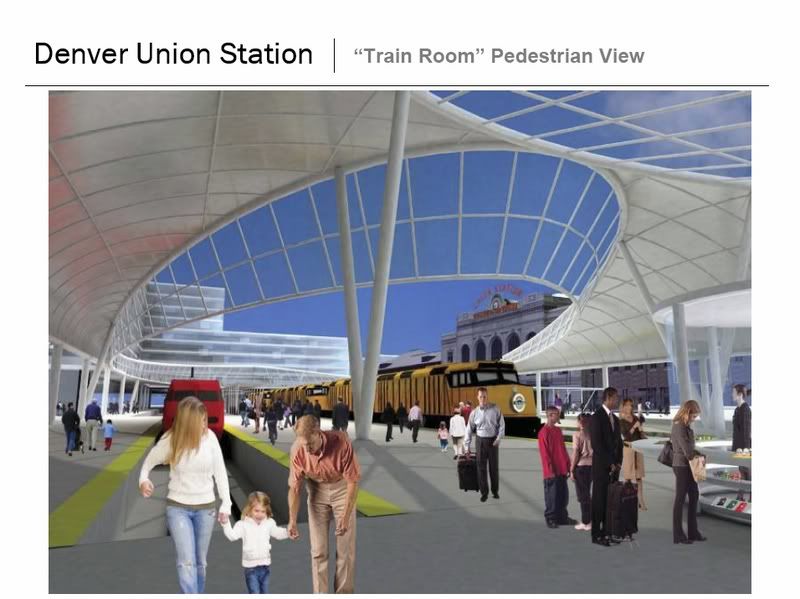
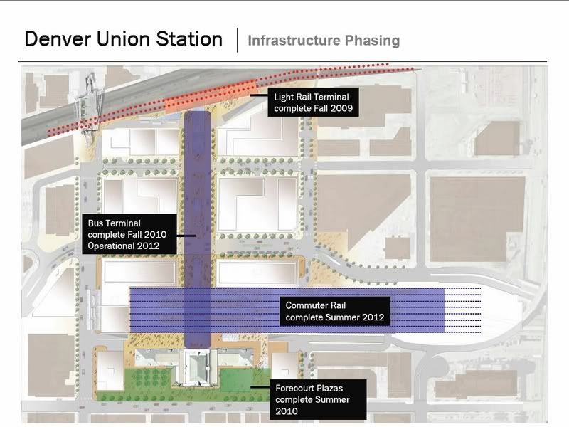
But of course, the center piece that everything feeds into, is Denver Union Station in LoDo (Lower Downtown). DUS will consist of four main parts: Historical Denver Union Station, Commuter Rail Terminal, Regional Bus Terminal and Light Rail Terminal.

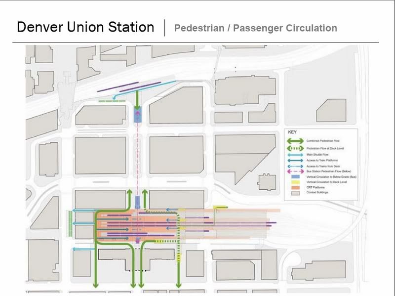
-The historical DUS building will serve as the gateway between the terminals and downtown. As well as serve as the main waiting area for longer duration transfer waits. The station will serve AmTrak, SkiTrain, Commercial buses and future inter-city rail in addition to the commuter rail, light rail and regional buses - so some transfer layovers will be longer than a few minutes.

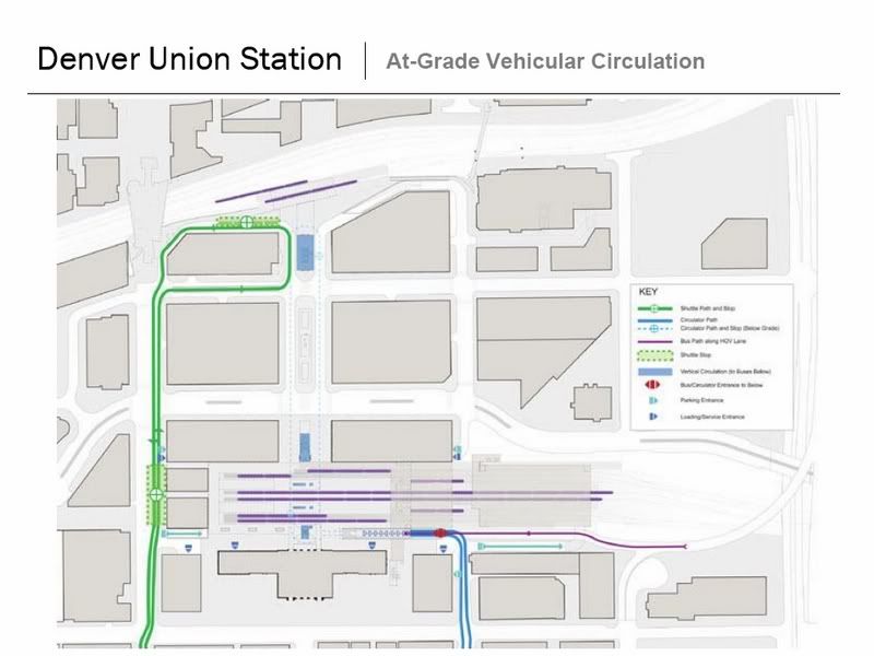
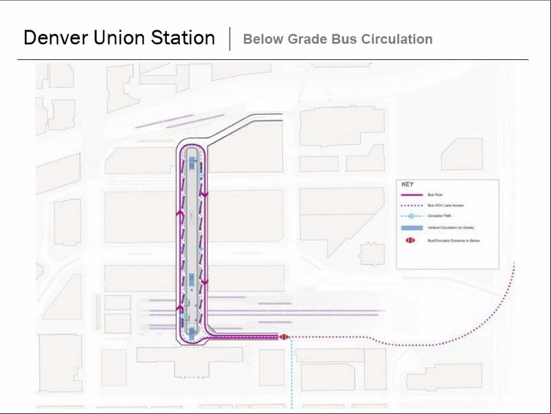
-The Commuter Rail Terminal (CRT) will consist of 8-tracks, directly behind the historic Union Station. It will be accessible directly from Union Station at-grade level, as well as have individual platform access from the subterranean Regional Bus terminal (RBT), and access from an elevated pedestrian bridge which crosses the tracks. It will be served by a below-grade 18th Street Free Circulator Bus stop, as well as an at-grade 16th Street Free Mall Ride Bus stop. In other words, this terminal will have seamless and integrated access from in front, behind, below, above, from the left and from the right of it.

-The Regional Bus Terminal (RBT) will be subterranean, below 17th Street Transportation plaza. This terminal will stretch from Union Station and the CRT, down to the Light Rail Terminal (LRT). There will be 22-bus bays; 16-regional bus bays, 4-Circulator bus bays, 2-commercial bus bays (actually a transfer bus which will shuttle passengers to and from commercial bus stations such as Greyhound). Down the medium of this will be an enclosed pedestrian walkway, with moving sidewalks to assist in transfers.

-At the far end of the RBT is the Light Rail Terminal (LRT). The LRT will have a 2-track covered platform with direct, covered access to the below-grade bus terminal and pedestrian tunnel to Union Station. There will also be room for a future third rail platform, which would be used for a separately proposed inter-city, Front Range Commuter High-Speed Rail Service from Fort Collins, CO to Albuquerque, NM (possibly El Paso/Juarez, Chihuahua, Mexico) and a separate Denver west to Ski resorts branch.

Denver Union Station:


Full Update Report: Click This Link

FasTracks: The Whole System
FasTracks is RTD's 12-year comprehensive plan to build and operate high-speed rail lines and expand and improve bus service and park-n-Rides throughout the region. FasTracks includes:

* 119 miles of new light rail and commuter rail
* 18 miles of bus rapid transit service
* 21,000 new parking spaces at rail and bus stations
* Expanded bus service in all areas

FasTracks provides many ways to ride a bus or train.

* Drive to a park-n-Ride and get on a bus or train
* Take a bus to a rail station
* Walk to a bus or rail station
* Ride your bike to transit stations and store your bike in lockers and racks or take it with you on buses and trains
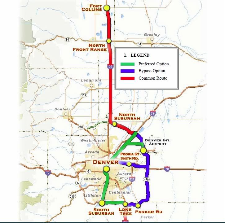


East Corridor
Vehicle Type: Commuter Rail - Electric Multiple Units (EMU)
Length (miles): 23.6
Stations: 5
Parking: 2,848 (existing), 400(new)
Capital Cost: $1.14B*
2030 Ridership: 37,500
Proposed Frequency of Service (Rail): 15 min (peak)/15 min (off-peak)

The East Corridor is a 23.6-mile commuter rail transit corridor between Denver Union Station and Denver International Airport (DIA). The East Corridor serves as a connection between these two important areas and travels through the adjacent employment, neighborhoods, and new development areas.

Final Design is scheduled to begin in 2008, and construction is scheduled to begin 2011 with opening day on the East Corridor scheduled for 2015.
--------------------------------------------------------------------------

North Metro Corridor
Vehicle Type: Commuter Rail - Diesel Multiple Units (DMU)
Length (miles): 18
Stations: 8
Parking: 2,992 (existing/planned), 3,767 (new)
Capital Cost: $637.2M*
2030 Weekday Ridership: 24,100
Proposed Frequency of Service (Rail): 15 min (peak)/30 min (off-peak)

The North Metro Corridor is a proposed 18-mile rail transit corridor
between Denver Union Station and 162nd Avenue, passing through Denver,Commerce City, Thornton, Northglenn and unincorporated Adams County. Project will be finished in 2015.
--------------------------------------------------------------------------

Northwest Rail Corridor
Vehicle Type: Commuter Rail - Diesel Multiple Units (DMU)
Length (miles): 41
Stations: 7 (rail)
Parking: 3,975 (existing), 4,393 (new)***
Capital Cost: $684.4M*
2030 Weekday Ridership: 17,400
Proposed Frequency of Service: 15 min (peak), 30 min (off-peak)

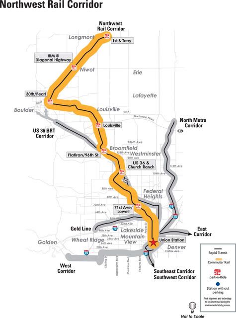
The Northwest Rail project is a proposed 41-mile high-capacity, fixed-guideway transit corridor from Denver Union Station to Longmont, passing through North Denver, Adams County, Westminster, Broomfield, Louisville, and Boulder. Project to be finished in 2014.
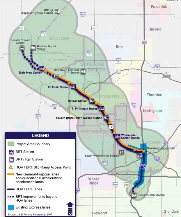
-------------------------------------------------------------------------

US 36 BRT Corridor
Vehicle Type: Bus Rapid Transit (BRT)
Length (miles): 18
Stations: 6
Parking: 3,975 (existing), 4,393 (new)***
Capital Cost: $235.6M*
2030 Weekday Ridership: 14,600
Proposed Frequency of Service: 2 min (peak), 4 min (off-peak)

The US 36 Corridor is an 18-mile Bus Rapid Transit Corridor between Downtown Denver and Boulder in the median of US 36. The FasTracks program includes funding for slip ramps and access improvements to park-n-Rides along the corridor. In addition, FasTracks funds centerline BRT stations, platforms and a proportional share of HOV lanes ($66 million) as part of future CDOT improvements to US 36.

The US 36 Corridor began as a two-pronged corridor; the BRT and the Commuter rail line from Denver through Boulder to Longmont. The rail and BRT corridors split into two separate projects in 2006 and are now known as the Northwest Rail Corridor and US 36 BRT Corridor.

The Environmental Impact Statement for US 36 began in 2003 and is planned to be complete in 2007. Phase 1 improvements, which include the slip ramps and some park-n-Ride improvements, will open in early 2009. Phase 2 Final Design is scheduled to begin in 2008, be completed in 2011 and the line is scheduled to open in 2015.


-----------------------------------------------------------------------------------------

Gold Line Corridor
Vehicle Type: Commuter Rail - Electric Multiple Units (EMU)
Length (miles): 11.2
Stations: 7
Parking: 711 (existing), 2,050 (new)
Capital Cost: $552.5M*
2030 Weekday Ridership: 18,000 - 20,000
Proposed Frequency of Service (Rail): 7.5 min (peak)/15 min (off-peak)

The Gold Line is a proposed 11.2-mile rail transit corridor from Denver Union Station to the vicinity of Ward Road, passing through northwest Denver, unincorporated Adams County, Arvada and Wheat Ridge. Project will be completed in 2015.
--------------------------------------------------------------------------

West Corridor
Vehicle Type: Light Rail
Length (miles): 12.1
Stations: 12
Parking: 646 (existing), 5,054 (new)
Capital Cost: $635M*
2030 Weekday Ridership: 31,200 - 36,500
Proposed Frequency of Service (Rail):
5 min (peak)/15 min (off-peak) Denver to Federal Center
15 min (peak and off-peak) Federal Center to Jefferson County

The West Corridor is a 12.1-mile light rail transit corridor between the Auraria Campus in downtown Denver and the Jefferson County Government Center in Golden, serving Denver, Lakewood, the Denver Federal Center, Golden and Jeffco.

The West Corridor completed the Environmental Impact Statement in 2003 and began Final Design in November 2005. The Final Design was completed in early 2008 and utility realignments were begun. In the summer of 2009, full construction phase was begun. It will be the first corridor to be completed in the FasTracks program, opening in early 2013.

-------------------------------------------------------------------------

Southwest Corridor
Vehicle Type: Light Rail
Length (miles): 8.7 (existing)/2.5 (new)
Stations: 5 (existing)/2 (new)
Parking: 2,597 (existing), 1,440 (new)
Capital Cost: $216.9M*
2030 Weekday Ridership: 21,600 - 24,000
Proposed Frequency of Service (Rail): 6 min (peak)/7.5 min (off-peak)

The Southwest Corridor light rail line opened in July 2000 as an 8.7-mile extension from I-25/Broadway to Mineral Avenue in Littleton. The Southwest Corridor has five stations with nearly 2,600 parking spaces.

A number of enhancements are proposed as part of FasTracks to make the Southwest line even more successful than it is today. Enhancements include improving existing stations so that they can accommodate four-car trains, adding a total of 440 parking spaces at the Englewood Station, and extending the line south from Mineral Avenue to Lucent Boulevard in Highlands Ranch with a new station at C-470/Lucent Boulevard with 1,000 new parking spaces. Finally, a new station will be added in Englewood at Bates Avenue when a new planned development is constructed.
--------------------------------------------------------------------------

Southeast Corridor
Vehicle Type: Light Rail
Length (miles): 19.1 (existing)/2.3 (new)
Stations: 13 (existing)/3 (new)
Parking: 6,962 (existing), 2,520 (new)
Capital Cost: $208.1M*
2030 Weekday Ridership: 51,100 - 59,800
Proposed Frequency of Service (Rail): 4 min (peak)/6 min (off-peak)

The Southeast Corridor is a 19.1-mile light rail line from I-25/ Broadway to Lincoln Avenue in Douglas County with an additional connection from I-25 to Parker Road along I-225. This portion of the Southeast Corridor began passenger service in November 2006.

FasTracks enhancements include a 2.3 mile light rail extension to Lone Tree, increasing total corridor parking by 2,520 spaces, and improving existing stations so that they can accommodate four-car trains.
-------------------------------------------------------------------------

I-225 Corridor
Vehicle Type: Light Rail
Length (miles): 10.5
Stations: 7
Parking: 1,225 (existing), 1,800 (new)
Capital Cost: $619.6M*
2030 Weekday Ridership: 34,200
Proposed Frequency of Service (Rail): 7.5 min (peak)/10 min (off-peak)

The I-225 Corridor project is a 10.5-mile proposed light rail line that connects the Southeast Corridor light rail station at Parker Road and I-225 and the East Corridor at Smith Road and Peoria. The alignment follows I-225 in the median between the Parker Road and the Aurora City Center area where it leaves the median and travels through the Aurora City Center area. The alignment returns to the median of I-225 and continues to Colfax Avenue where it turns west to serve the Fitzsimons redevelopment area. This proposed light rail mode line continues north along Peoria Street to Smith Road, where a cross-platform transfer to the East Corridor rail line to the Denver International Airport (DIA-eastbound) or downtown (DUS-westbound), is provided.

The I-225 Corridor will serve Aurora (300,000 people), in addition to providing a key regional rail linkage between the East and Southeast rail lines and connecting the regions 2nd largest job center (Denver tech Center) to the regions Airport (DIA).
-------------------------------------------------------------------------

Central Corridor
Vehicle Type: Light Rail
Length (miles): 7.1 (existing)/0.8 (new)
Stations: 18 (existing)/2 (new)
Parking: 1,685 (existing)
Capital Cost: $115M*
2030 Weekday Ridership: 5,800
Proposed Frequency of Service (Rail): 15 min


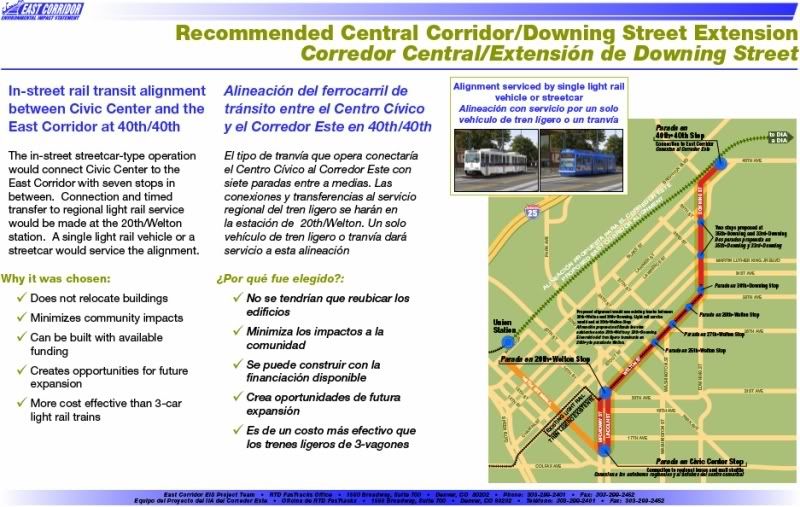
The 5.3 mile Central Corridor light rail line originally opened in 1994 and is Denver's first light rail line running from I-25/Broadway, through downtown Denver, and along Welton Street to 30th/Downing. The light rail extension as part of FasTracks takes the line north on Downing Street less than a mile to the 40th/40th Station, where it will share a transfer station with the East Corridor. This line is being studied for a potential conversion into a streetcar style single light rail vehicle line--as it runs on city core streets.
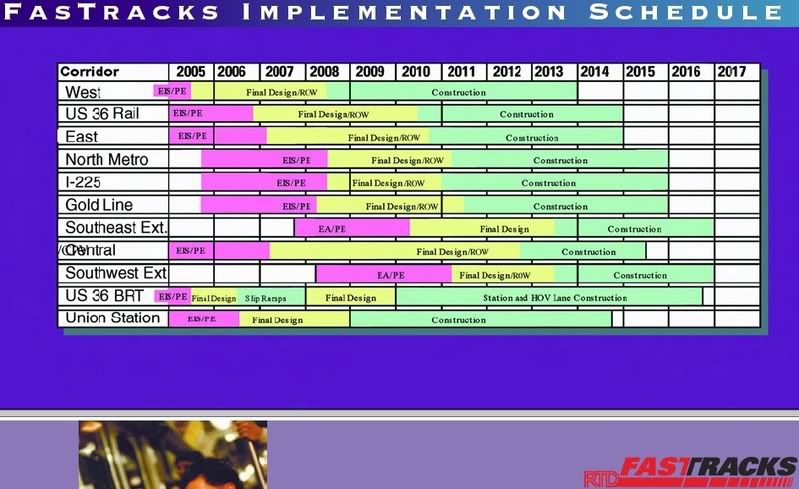
-------------------------------------------------------------------------------
Schedule:


RTD FasTracks FAQ's
RTD Transit Tech PDF
RTD FasTracks Factbook PDF
__________________
Automation Is Still the Future

Last edited by SnyderBock; Jan 24, 2011 at 1:16 PM.
Reply With Quote
     
     
  #165  
Old Posted Oct 9, 2009, 3:08 PM
esirhgih's Avatar
esirhgih esirhgih is offline
Registered User
 
Join Date: Aug 2006
Location: Salt Lake
Posts: 188
I love Denver's plans to make their historic station a functioning part of the modern transportation network. Salt Lake still has its old train depots but they aren't being put to use as actual train stations anymore, which is kind of sad.

How much of the FasTracks plan is actually funded and under construction? It's a great plan, but I keep hearing conflicting things about what is actually under way now, and what is just a long-term plan.
Reply With Quote
     
     
  #166  
Old Posted Oct 9, 2009, 3:28 PM
SnyderBock's Avatar
SnyderBock SnyderBock is offline
Robotic Construction
 
Join Date: Sep 2006
Posts: 3,833
The West Corridor Light Rail is under-construction. Union Station is about to begin construction. The East Corridor begins construction in Early 2011. Actually, the schedule says it all.

The entire project and all the lines have local funding via the sales tax and all of it will get built. All the components are supposed to be completed before 2018. The main problem is that sales tax collections went way below projections with the recession. So now in order to build all the lines by 2018, they need another sales tax increase (to be voted on next year). If voters don't pass that, everything will still get built, but only the West Corridor, East Corridor, Gold Line and Union Station will get built before the 2018 deadline. The North, Northwest, I-225 and existing light rail line extensions would have to be delayed to as late as 2034 (if no additional funding were found).

So the most important lines will be built by 2018 with or without the additional sales tax. The other lines will also be built by 2018, if the additional tax is passed by voters next year. If it is not passed, those lines will still be built by 2034. There is also a possibility of those lines being built out only partway by 2018, then phasing their extensions out to 2034 or later.

If the new Federal Transportation Bill gets passed next year and has a huge increase in transit funding (as speculated), The East and Gold lines could get a 50-60% Federal match instead of the currently expected 40% Federal match, which would free up more funds for the other lines and ease the budget gap considerably.

But to directly answer your question... All of it is currently underway and funded. None of it is "just a long-term plan." Each component of FasTracks has funding lined up for it's original projected cost in 2004 and are all in various advanced stages of study/design or construction. The issues you have read are about the budget gap which has widened since 2004. Denver/RTD has enough to cover $5.7 billion in construction, but new estimates are that it will cost a total of $7.1 billion. All lines are funded up to that $5.7 billion budget (including expected federal contributions) and are actual projects underway -- they just need to find additional funds to close the gap to keep all the lines' construction schedules on track, without delays.
__________________
Automation Is Still the Future

Last edited by SnyderBock; Oct 9, 2009 at 3:39 PM.
Reply With Quote
     
     
  #167  
Old Posted Oct 9, 2009, 4:35 PM
esirhgih's Avatar
esirhgih esirhgih is offline
Registered User
 
Join Date: Aug 2006
Location: Salt Lake
Posts: 188
Quote:
Originally Posted by SnyderBock View Post
But to directly answer your question... All of it is currently underway and funded. None of it is "just a long-term plan." Each component of FasTracks has funding lined up for it's original projected cost in 2004 and are all in various advanced stages of study/design or construction. The issues you have read are about the budget gap which has widened since 2004. Denver/RTD has enough to cover $5.7 billion in construction, but new estimates are that it will cost a total of $7.1 billion. All lines are funded up to that $5.7 billion budget (including expected federal contributions) and are actual projects underway -- they just need to find additional funds to close the gap to keep all the lines' construction schedules on track, without delays.
Thank you. That is the concise answer I have been looking for.
Reply With Quote
     
     
  #168  
Old Posted Oct 9, 2009, 7:08 PM
jaxg8r1 jaxg8r1 is offline
Registered User
 
Join Date: Jun 2003
Location: Portland, OR
Posts: 1,518
Quote:
Originally Posted by SnyderBock View Post
The West Corridor Light Rail is under-construction. Union Station is about to begin construction. The East Corridor begins construction in Early 2011. Actually, the schedule says it all.

The entire project and all the lines have local funding via the sales tax and all of it will get built. All the components are supposed to be completed before 2018. The main problem is that sales tax collections went way below projections with the recession. So now in order to build all the lines by 2018, they need another sales tax increase (to be voted on next year). If voters don't pass that, everything will still get built, but only the West Corridor, East Corridor, Gold Line and Union Station will get built before the 2018 deadline. The North, Northwest, I-225 and existing light rail line extensions would have to be delayed to as late as 2034 (if no additional funding were found).

So the most important lines will be built by 2018 with or without the additional sales tax. The other lines will also be built by 2018, if the additional tax is passed by voters next year. If it is not passed, those lines will still be built by 2034. There is also a possibility of those lines being built out only partway by 2018, then phasing their extensions out to 2034 or later.

If the new Federal Transportation Bill gets passed next year and has a huge increase in transit funding (as speculated), The East and Gold lines could get a 50-60% Federal match instead of the currently expected 40% Federal match, which would free up more funds for the other lines and ease the budget gap considerably.

But to directly answer your question... All of it is currently underway and funded. None of it is "just a long-term plan." Each component of FasTracks has funding lined up for it's original projected cost in 2004 and are all in various advanced stages of study/design or construction. The issues you have read are about the budget gap which has widened since 2004. Denver/RTD has enough to cover $5.7 billion in construction, but new estimates are that it will cost a total of $7.1 billion. All lines are funded up to that $5.7 billion budget (including expected federal contributions) and are actual projects underway -- they just need to find additional funds to close the gap to keep all the lines' construction schedules on track, without delays.
Do you know how much of a sales tax increase this was (and the duration?). Thanks in advance
Reply With Quote
     
     
  #169  
Old Posted Oct 9, 2009, 11:40 PM
SnyderBock's Avatar
SnyderBock SnyderBock is offline
Robotic Construction
 
Join Date: Sep 2006
Posts: 3,833
In 2004, voters passed a 0.4% sales tax increase for the 7 county RTD (Regional Transportation District) region to build FasTracks. Upon RTD's formation in 1977, a 0.6% sales tax was put in place to cover it's operational costs, so the increase of 0.4% brings RTD's total sales tax up to 1%. There is no set duration to this tax. It will take at least 30 years of tax collections to pay FasTracks off, at which point significant maintenance and upgrades are likely to be needed.

In 2010, voters in the 7 county RTD district will vote on an additional sales tax of up to 0.4%, to balance the budget and allow for full build-out of all lines by the 2018 date. If passed by voters, this additional sale tax will also likely allow for enhancements in system security and function to be added back in to their designs. This additional sales may also make it possible for one or more additional (yet to be planned) lines to be added to the plan and built after 2018. Candidates would be a Denver to Cherry Creek rail connection and/or a Denver to Aurora streetcar line down Colfax or perhaps even Union Station upgrades to better allow it to accommodate a proposed inter-city 220-mph high speed rail line (which is proposed to connect Denver-Colorado Springs-Pueblo; Denver-Fort Collins; Denver-Black Hawk-Keystone-Breckenridge-Vail). The following is information pertaining this this HSR line. Sorry to get off topic a little here, but in case you all didn't know about this plan, here's some info...

Quote:
Here is the latest report from the Rocky Mountain Rail Authority (RMRA). Their study is entering into advanced stages now. They have determined the exact alignment for about 80% of the route. They have also determined they will pursue non-FRA compliant alignments and technology (220-mph tilting EMU in dedicated ROW), for the east-west and north-south lines (as to maintain system compatibility). The Downtown Denver bypass would not actually bypass downtown, except from the south approach. All lines would still provide direct service to downtown Denver via the east-west line.

As far as the downtown Colorado Springs alternative, it would get bypassed completely--if they go with that alignment. It would reduce cost, reduce travel times and provide better access to Colorado Springs International Airport. Plus I think Colorado Springs could build a small Light Rail starter line connecting downtown to the two HSR stations the city would gain (or at least BRT).

Here's the report:
RMRA Executive Committee Mtg7


Denver North to Fort Collins:


Denver West to Black Hawk-Keystone-Breckenridge-Vail:


Denver South to Colorado Springs-Pueblo:

Courtesy of RMRA
__________________
Automation Is Still the Future

Last edited by SnyderBock; Oct 9, 2009 at 11:53 PM.
Reply With Quote
     
     
  #170  
Old Posted Jan 5, 2010, 1:54 PM
Nexis4Jersey's Avatar
Nexis4Jersey Nexis4Jersey is offline
Greetings from New Jersey
 
Join Date: Mar 2009
Location: North Jersey
Posts: 3,278
This isn't really local , but since New Jersey is so small it kinda counts.

NJT Rail , unfortunately this doesn't include all the Ext UC , like the Middlesex-Ocean-Monmouth or MOM network planned. Or the Riverline Ext to Glassboro. Or the West Trenton Restoration : West Trenton-Bridgewater. & the 2 Ext West to PA. Nor does it include the Essex , Union Proposed & planned Light Rail networks.


~Corey
Reply With Quote
     
     
  #171  
Old Posted Jan 21, 2010, 8:59 AM
pdxtex's Avatar
pdxtex pdxtex is offline
Registered User
 
Join Date: Jan 2004
Location: Portland, OR
Posts: 3,124
im proud of portland. ive only been here since 97 and max has pretty much tripled in size since then. sweet. you can get to the airport, go north to the columbia river, south to the clackamas area, and all the way out to hillsboro. we only have 2 million people but alot of people ride transit for sure.
__________________
Portland!! Where young people formerly went to retire.
Reply With Quote
     
     
  #172  
Old Posted Apr 28, 2010, 3:52 AM
Prahaboheme Prahaboheme is offline
Registered User
 
Join Date: Apr 2003
Posts: 1,690
Orlando's 61 mile / 17 station commuter rail system to break ground later this year (approved):


Not pictured: An extension has been incorporated to shoot out to the Airport and will connect directly with high speed rail (also approved and should break ground in 2011).

It's a start...
Reply With Quote
     
     
  #173  
Old Posted Apr 28, 2010, 12:09 PM
Tolbert Tolbert is offline
Registered User
 
Join Date: May 2008
Posts: 238
Frankfurt Main (Germany)

Commuter Rail (S-Bahn)


Tram and underground lines


there are bus lines as well but i coulnd't find a map


The city i live in Darmstadt (30km south of Frankfurt)

the Tram lines


the bus lines and tram lines

http://www.dadina.de/fileadmin/user_...adt_A3_neu.pdf
__________________
Limburg Nürnberg Heidelberg
Reply With Quote
     
     
  #174  
Old Posted Apr 28, 2010, 1:41 PM
jpIllInoIs's Avatar
jpIllInoIs jpIllInoIs is offline
Registered User
 
Join Date: Dec 2005
Posts: 1,213
Quote:
Originally Posted by cubs20089 View Post

^ Chicago CTA map above

v Chicago & Suburban METRA map below


v Chicago & South Bend commuter rail below

Reply With Quote
     
     
  #175  
Old Posted May 21, 2010, 6:50 PM
M II A II R II K's Avatar
M II A II R II K M II A II R II K is offline
Registered User
 
Join Date: Aug 2002
Location: Toronto
Posts: 52,200
One can also create their own maps through this method.

http://en.wikipedia.org/wiki/Wikiped...pological_maps
__________________
ASDFGHJK
Reply With Quote
     
     
  #176  
Old Posted Jun 7, 2010, 12:32 PM
tdawg's Avatar
tdawg tdawg is offline
Registered User
 
Join Date: Jan 2007
Location: Astoria, NY
Posts: 2,937
The NYTimes did a feature on the new subway changes, and new MTA map, recently that was pretty interesting. Major changes include the elimination of the V and W trains, and the re-routing of the M up 6th Avenue.

http://www.nytimes.com/interactive/2...ubway-map.html
__________________
From my head via my fingers.
Reply With Quote
     
     
  #177  
Old Posted Jul 8, 2010, 6:50 PM
zeno3333333 zeno3333333 is offline
Registered User
 
Join Date: Nov 2008
Posts: 71
Quote:
Originally Posted by esirhgih View Post
Thanks for sharing.
I honestly never knew that Pittsburgh had a rail system at all.
Where have I been?
Its what remains of the former massive PCC streetcar system that was gradually done away with from 1964 to 1967 or so...(the North Side lines in 1966 and the east End lines in early 1967). The current lines were left running PCC cars, but now the cars and the tracks are of modern Light rail design. The line that ends at Library until 1953 continued a long way into the towns along the Mon river...the former Drake Line, that seems will never get rebuilt, used to go all the way to washington, PA...thats why there's still a "Washington Jnct". As a kid I rode the East End lines until they were removed in January, 1967.
Reply With Quote
     
     
  #178  
Old Posted Sep 21, 2010, 2:24 AM
garimeme garimeme is offline
Registered User
 
Join Date: Sep 2010
Posts: 1
As GIS professionals we were inspired by Kenya's plan, "Nairobi Metro 2030," published by the Ministry of Nairobi Metropolitan Development. Its Section 4.3.2.2 calls for a rapid transit system to modernize the commuter rail. As you may know, presently Nairobi suffers from debilitating traffic on its surface roads in and out of the Central Business District.

We just published one vision for such a Subway for Nairobi. It would serve the various informal settlements as well as wealthier neighborhoods, to get people around to work and to home:

http://www.garimeme.com/

Reply With Quote
     
     
  #179  
Old Posted Oct 19, 2010, 4:15 PM
eburress's Avatar
eburress eburress is offline
Registered User
 
Join Date: Sep 2005
Posts: 1,526
Quote:
Originally Posted by electricron View Post
I've always thought that a subway line underneath or adjacent to the Dallas North Tollway, from Downtown to Plano/Frisco would be huge for the region. Imagine stops throughout Uptown, Cedar Springs, Highland Park Village, Northwest Highway, The Galleria, Addison, Legacy, etc. That corridor is as busy as can be and it's only going to get worse (or better, depending on your POV).

(I realize the cost would be astronomical and that Highland Park residents wouldn't let it happen in a million years. Still though...)
Reply With Quote
     
     
  #180  
Old Posted Oct 19, 2010, 7:59 PM
electricron's Avatar
electricron electricron is offline
Registered User
 
Join Date: Aug 2008
Location: Granbury, Texas
Posts: 3,523
Lightbulb

Quote:
Originally Posted by eburress View Post
I've always thought that a subway line underneath or adjacent to the Dallas North Tollway, from Downtown to Plano/Frisco would be huge for the region. Imagine stops throughout Uptown, Cedar Springs, Highland Park Village, Northwest Highway, The Galleria, Addison, Legacy, etc. That corridor is as busy as can be and it's only going to get worse (or better, depending on your POV).

(I realize the cost would be astronomical and that Highland Park residents wouldn't let it happen in a million years. Still though...)
Don't forget University Park, North Dallas, and Far North Dallas would join Highland Park nimbyers. Sort of a moot point, but DART won't have the money to spend on this route (corridor) for at least another 30 years. Between the Galleria area and downtown Dallas, there really isn't anything that can't be service by streetcars, the MATA already exists on McKinney Ave. Another streetcar line on Cedar Springs would work just as well.
The Galleria area and Addison will have east-west Cotton Belt regional rail services. Frisco, which isn't a member of DART, is planning a commuter rail line to Carrollton. DART already runs Express bus service on the Dallas North Tollway, with several express bus park & ride lots already in existence. DART would have to build a 10-15 mile tunnel under the Tollway to add rail to this corridor. A tunnel will double or triple the costs, pushing affordability out 40-50 years. Therefore, I doubt DART will build a light rail line on this corridor soon, but everything is possible when looking out 40-50 years into the future..
Rail was an option 50 years ago, with the old Cotton Belt spur used by the Dallas North Tollway. But 6 lanes of tollway fits in the corridor now.
Reply With Quote
     
     
This discussion thread continues

Use the page links to the lower-right to go to the next page for additional posts
 
 
Reply

Go Back   SkyscraperPage Forum > Discussion Forums > Transportation
Forum Jump


Forum Jump


All times are GMT. The time now is 11:38 AM.

     
SkyscraperPage.com - Archive - Privacy Statement - Top

Powered by vBulletin® Version 3.8.7
Copyright ©2000 - 2024, vBulletin Solutions, Inc.