Quote:
Originally Posted by ns_kid

.....Directly behind the most distant group of RDCs is the massive coaling tower, unused since CN retired its last steam locos circa 1960.
|
Haha, I'm glad you identified that tower. It was the first thing my eyes went to wondering what it was.
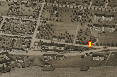
So guys, I've really enjoyed the last few posts. Based on the map posted by ns_kid it looks like our mystery building is the Freight Car Repair Shop, eh? Pretty cool to have officially identified what it's purpose was. That's actually the first time I've seen that map so thanks for posting that! Going to be a good resource for future "spelunking". I'd like to be able to chime in with some info here but you guys are far more knowledgeable on this subject than I am. I did however find some interesting photos:
OLD NORTH END
I found this little snippit from the "Old North End" blog which accompanied the photo below. I'm thinking ns_kid this is probably one of the photos you had seen that were poor quality:

Source: Old North End blog -
https://oldnorthend.files.wordpress....m200700525.jpg
"The above photo from the Tom Connors collection held at the Nova Scotia Archives shows the Richmond train/freight station ca. 1860. The shabby conditions of the Richmond station led to the train station being moved in 1878 to the foot of North Street. However, the train terminus was one of the main reasons for the settlement on this part of peninsula.
PIER21
Pier 21 has an interesting write up on their web site which mentions the Richmond Station. In regards to providing proper accommodations for immigrants after the Deep Water Terminal burnt:
"The work to establish proper reception facilities was undone by fire in February of 1895. Much of the infrastructure at the Deep Water Terminus burned, including the immigration quarters.[6] In the absence of proper landing facilities, passengers were landed at Cunard’s wharf (just south of Pier 2) and examined at the North End railway station.[7] The Intercolonial Railway moved quickly to rebuild, and had plans in place by the end of the next month.[8] However, the search for replacement accommodation became even more pressing in the spring, as a blaze took the Intercolonial Railway’s Richmond terminal (in the North End of Halifax, near the foot of Richmond Street) in May of 1895. Although a bit further from the railway station, the pier and shed at Richmond had been used at times to assist in clearing immigrants after the February fire."
Source: Peir21.ca -
https://pier21.ca/research/immigrati...before-pier-21
Maritime Museum had a few images on their site speaking of train dispatcher Vincent Coleman/Richmond & the Halifax Explosion. I'm wondering if the buildings in the middle of the photo are the same ones as the first image posted above?

Source: Maritime Museum -
https://maritimemuseum.novascotia.ca...ifax-explosion

Source: Maritime Museum -
https://maritimemuseum.novascotia.ca...ifax-explosion
NS ARCHIVES
The images below were taken from a newspaper article which is the same one OldDartmouthMark came across the "blown to atoms" quote. I'm not sure if the map will come in handy or not but I thought I'd post anyway as it shows the Willow Park Roundhouse & Shops. The legend shows them in the damaged area which supports everyone's theory that they were damaged in the Explosion.

Source: NS Archives -
https://novascotia.ca/archives/MacMe...Page=201761293

Source: NS Archives -
https://novascotia.ca/archives/MacMe...Page=201761292
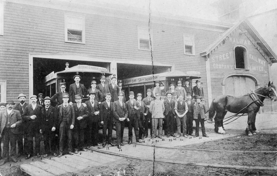
Lastly, I came across this little gem on the Fairview Historical Society site. The quality of the image wasn't that great on their site but it's a fantastic shot of the roundhouse, eh? The caption reads:
"Fairview Cove Roundhouse - 1960
The Canadian National Railway's Locomotive Deposit in Fairview Cove area of Bedford Basin. The Roundhouse and Switching Yard services both freight and passenger trains".

Source: Fairview Historical Society -
http://fairviewhistoricalsociety.ca/...-and-fairview/


 Prev
Prev


 And by only a few minutes! Those are great photos you found man! Especially the Willow Park Images. Nice one!


 Linear Mode
