HomeDiagramsDatabaseMapsForum About
     

Go Back   SkyscraperPage Forum > Photography Forums > Found City Photos

Reply

 
Thread Tools Display Modes
     
     
  #24641  
Old Posted Nov 15, 2014, 2:30 AM
Tetsu Tetsu is offline
Registered User
 
Join Date: Aug 2013
Posts: 180
About Pasadena's YMCA Building(s)

Quote:
Originally Posted by HossC View Post
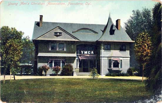
According to the October 4, 1910 edition of the Los Angeles Herald, the YMCA building in Pasadena was at Raymond Avenue and Ramona Street.
I found this clipping through a great article on chandlermuseum.org. It has the story below, and several other clippings from old newspapers
relating to the fundraising.


California Digital Newspaper Collection

Here's another postcard of the building.


www.usgwarchives.net

It doesn't look like Raymond Avenue and Ramona Street actually intersect anymore (if they ever did). The location would be near Pasadena's Memorial
Park, so the YMCA building would have been a near neighbor of the old public library written about by sopas ej back in post #4465. The postcard
below shows the YMCA's building at 235 E Holly Street, which is about a block away from Raymond Avenue, and backs onto Ramona Street. It's dated
by the seller as 1950s. I've been trying to work out when it replaced the building above. A 1987 article in the LA Times discusses the proposed closure
of this facility, and describes it as a "76-year-old building", which would date it as one year younger than the building above. Maybe they meant that
a YMCA building had been there that long.


eBay

This building's still there, although it's lost the balconies on the right.
Hey all, I've gone back to lurking for a while (not on purpose, but the knowledge everyone else has to share here is always so impressive that I often don't know what more I can possibly add), but I think I can shed a little more light on this one. The YMCA at the NE corner of Marengo & Holly was built in 1910 (architect Arthur Benton). It was then remodeled in the mid 1920's (architects Marston & van Pelt) into the building that currently stands today (apparently it was a heavy remodel that all but obliterated the original design). Originally the Marengo (west) side of the building was the front facade, but it was changed to the Holly (south) side during the remodel. Apparently Holly did not extend through at the time, but this was changed due to the construction of the city hall at the east end of Holly. The remodel was to make the architecture of the building more in line with the Spanish/Mediterranean architecture of the other civic center buildings which were going up at the time.

As for the YMCA building in the postcard, I'd have to guess that it was an entirely different structure, since Raymond & Ramona would have been about a block to the west as HossC said. It looks to be in the Shingle style which was more popular in the mid to late 1890's and early 1900's. I wouldn't be one bit surprised if it was designed by Fredrick Roerhig, probably the most prolific architect in Pasadena, whose style was often characterized by dramatic curves, towers, and angles like the steep pointed roof the building had.
Reply With Quote
     
     
  #24642  
Old Posted Nov 15, 2014, 4:29 PM
ethereal_reality's Avatar
ethereal_reality ethereal_reality is offline
Registered User
 
Join Date: Feb 2008
Location: Lafayette/West Lafayette IN, Purdue U.
Posts: 16,346
I searched through the various maps on NLA and I don't believe we've seen this one. (if we have so be it...it's cool enough to see again)


1932 Children's Map of Los Angeles "The Wonder City"


http://www.lataco.com/taco/1932-chil...he-wonder-city

This map is so fun! -even the Paris Inn appears.


http://www.lataco.com/taco/1932-chil...he-wonder-city

"Blimp" Landing Field north(?) of Baldwin Hills. I spy the Rollerdome. -and King's Tropical Inn which we discussed yesterday.


http://www.lataco.com/taco/1932-chil...he-wonder-city

-note the Breakers Hotel I spoke about in a recent post. (as well as the Villa Rivera)

Here's the whole map with the Index.
http://www.bigmapblog.com/2011/los-a...-america-1934/

Last edited by ethereal_reality; Nov 15, 2014 at 5:00 PM.
Reply With Quote
     
     
  #24643  
Old Posted Nov 15, 2014, 4:53 PM
ethereal_reality's Avatar
ethereal_reality ethereal_reality is offline
Registered User
 
Join Date: Feb 2008
Location: Lafayette/West Lafayette IN, Purdue U.
Posts: 16,346
Tourist takes a snapshot of Charles Boyer on Vine Street, ca. 1942.


ebay
Reply With Quote
     
     
  #24644  
Old Posted Nov 15, 2014, 7:49 PM
JScott's Avatar
JScott JScott is offline
Registered User
 
Join Date: Feb 2013
Posts: 183
Quote:
Originally Posted by ethereal_reality View Post

I cannot imagine what made that blogger think this was a map made for children. He must not have looked at it very closely. Ahem -- "NUDE SUN BATHS" in Santa Monica? WHAT? I'm sure "TOPSY'S NIGHT CLUB" in Huntington Park would be a real wholesome place to take the kiddies, too. And "Hey look, Mommy! Could we please go to 'EDWARDS BROS. COLONIAL MORTUARY' today? That sounds like it would be so much fun!"
__________________
Covina Past
Los Angeles Past
Reply With Quote
     
     
  #24645  
Old Posted Nov 15, 2014, 9:11 PM
ethereal_reality's Avatar
ethereal_reality ethereal_reality is offline
Registered User
 
Join Date: Feb 2008
Location: Lafayette/West Lafayette IN, Purdue U.
Posts: 16,346
Here's an interesting view of the Mulholland Dam before it was covered in 330,000 cu yd of earth. (I imagine this guy lost his little rock garden)


ebay

Reply With Quote
     
     
  #24646  
Old Posted Nov 15, 2014, 9:18 PM
ethereal_reality's Avatar
ethereal_reality ethereal_reality is offline
Registered User
 
Join Date: Feb 2008
Location: Lafayette/West Lafayette IN, Purdue U.
Posts: 16,346
I've been trying to figure out where the photograph was located when he took this slide.


ebay
__
Reply With Quote
     
     
  #24647  
Old Posted Nov 15, 2014, 9:27 PM
ethereal_reality's Avatar
ethereal_reality ethereal_reality is offline
Registered User
 
Join Date: Feb 2008
Location: Lafayette/West Lafayette IN, Purdue U.
Posts: 16,346
Here are more slides that I believe are by the same amateur photograph. (I've collected them over the 5 or 6 months on ebay)


Any help would be appreciated.

ebay

above: I believe that's the prominent art deco apartment building on Los Feliz (that we've discussed several times on NLA).


ebay


ebay


ebay


below: We've pretty much seen this same view before....but the gas-o-meter looks especially good in this one.

ebay


below: No idea on this one.

ebay

This guy really got around.

__

Last edited by ethereal_reality; Nov 18, 2014 at 3:25 AM.
Reply With Quote
     
     
  #24648  
Old Posted Nov 15, 2014, 9:33 PM
ethereal_reality's Avatar
ethereal_reality ethereal_reality is offline
Registered User
 
Join Date: Feb 2008
Location: Lafayette/West Lafayette IN, Purdue U.
Posts: 16,346
And probably the most enigmatic of the lot is this one.


ebay

Any ideas? -the French Village?
__

I'm out of town until Monday. Have fun everyone!
Reply With Quote
     
     
  #24649  
Old Posted Nov 15, 2014, 10:34 PM
HossC's Avatar
HossC HossC is online now
Registered User
 
Join Date: Aug 2013
Posts: 4,245
Quote:
Originally Posted by ethereal_reality View Post

I've been trying to figure out where the photograph was located when he took this slide.


ebay
This view is looking down Fountain Avenue, possibly from Lucile Avenue, which is where the GSV image below was taken.


GSV

Several blocks back is the Hollywood Presbyterian Medical Center. Due to additional structures, this side of the building is now hidden, but here it is in a bit of stock footage which appeared briefly in 'The Dukes of Hazzard'. The 'City General Hospital' sign is a prop.


Warner Bros.
Reply With Quote
     
     
  #24650  
Old Posted Nov 15, 2014, 11:23 PM
Those Who Squirm!'s Avatar
Those Who Squirm! Those Who Squirm! is offline
Registered User
 
Join Date: Jan 2011
Location: In my specially built chair
Posts: 376
Quote:
Originally Posted by ethereal_reality View Post
I searched through the various maps on NLA and I don't believe we've seen this one. (if we have so be it...it's cool enough to see again)


1932 Children's Map of Los Angeles "The Wonder City"


This map is so fun! -even the Paris Inn appears.
It doesn't seem like a "children's" map in particular, with country clubs and cafes prominently featured.

Oh I get it, probably it was drawn by children.
__________________
The new Wandering In L.A. post is published!

This Is Probably The Oldest Intact School Building In L.A.
Reply With Quote
     
     
  #24651  
Old Posted Nov 15, 2014, 11:49 PM
CityBoyDoug CityBoyDoug is offline
BANNED
 
Join Date: Apr 2013
Posts: 2,868
Quote:
Originally Posted by ethereal_reality View Post
Tourist takes a snapshot of Charles Boyer on Vine Street, ca. 1942.


ebay
ER....this car had me very puzzled. I did a lot of research and finally ID'd it.

This is a 1941 Cadillac Series 62 convertible. It has a very distinctive hood badge. As far as I know, this is the only Series Cadillac and the only year this badge was ever applied.

This was one of the last Cadillacs built before war production began. During the war, Cadillac made tank engines.

Recently this rare type of car sold for $46,000.


carpictures dot com


galleryhip dot com

Last edited by CityBoyDoug; Nov 16, 2014 at 12:03 AM.
Reply With Quote
     
     
  #24652  
Old Posted Nov 15, 2014, 11:57 PM
JScott's Avatar
JScott JScott is offline
Registered User
 
Join Date: Feb 2013
Posts: 183
Quote:
Originally Posted by ethereal_reality View Post
ebay

This one is mirrored/reversed.


__________________
Covina Past
Los Angeles Past

Last edited by JScott; Dec 27, 2017 at 12:33 AM. Reason: Repaired broken image link
Reply With Quote
     
     
  #24653  
Old Posted Nov 16, 2014, 12:05 AM
JScott's Avatar
JScott JScott is offline
Registered User
 
Join Date: Feb 2013
Posts: 183
Quote:
Originally Posted by ethereal_reality View Post
ebay

I suspect this one may be, too.

__________________
Covina Past
Los Angeles Past

Last edited by JScott; Dec 27, 2017 at 12:32 AM. Reason: Repaired broken image link
Reply With Quote
     
     
  #24654  
Old Posted Nov 16, 2014, 12:07 AM
CityBoyDoug CityBoyDoug is offline
BANNED
 
Join Date: Apr 2013
Posts: 2,868
Quote:
Originally Posted by JScott View Post
This one is mirrored/reversed.


Good eye JScott...!!!

Could this be the outer edge of Chavez Ravine? [See posts below for correct location.]

Last edited by CityBoyDoug; Nov 16, 2014 at 3:50 AM.
Reply With Quote
     
     
  #24655  
Old Posted Nov 16, 2014, 12:26 AM
JScott's Avatar
JScott JScott is offline
Registered User
 
Join Date: Feb 2013
Posts: 183
Quote:
Originally Posted by CityBoyDoug View Post
Good eye JScott...!!!

Could this be the outer edge of Chavez Ravine?


I kind of think we're looking down on City Terrace Dr. here from a hilltop to its east. Compare this view:

http://goo.gl/maps/50jmb

Even better:

http://goo.gl/maps/pZTuR
__________________
Covina Past
Los Angeles Past

Last edited by JScott; Nov 16, 2014 at 12:32 AM. Reason: Added URL of closer view
Reply With Quote
     
     
  #24656  
Old Posted Nov 16, 2014, 1:09 AM
HossC's Avatar
HossC HossC is online now
Registered User
 
Join Date: Aug 2013
Posts: 4,245


I think you're right (or at least pretty close) with your location, JScott. This 1964 aerial shows the road layout and buildings as they appear in e_r's picture. Both the large brick building in the foreground, and the elevated roadway behind it, have gone by 1972.


Historic Aerials
Reply With Quote
     
     
  #24657  
Old Posted Nov 16, 2014, 3:46 AM
CityBoyDoug CityBoyDoug is offline
BANNED
 
Join Date: Apr 2013
Posts: 2,868
Quote:
Originally Posted by HossC View Post


I think you're right (or at least pretty close) with your location, JScott. This 1964 aerial shows the road layout and buildings as they appear in e_r's picture. Both the large brick building in the foreground, and the elevated roadway behind it, have gone by 1972.


Historic Aerials
You guys are correct. That's Harrison Elementary School on City Terrance Dr, by the 10 Freeway. I was way off on calling it near Chavez Ravine...which is north of this location. Sorry, just another of my goofs.
above right: google earth view 2011

Last edited by CityBoyDoug; Nov 16, 2014 at 4:01 AM.
Reply With Quote
     
     
  #24658  
Old Posted Nov 16, 2014, 5:53 PM
MartinTurnbull's Avatar
MartinTurnbull MartinTurnbull is offline
Registered User
 
Join Date: Oct 2011
Location: Los Angeles
Posts: 223
Apartment building, 1946

This photo was dated 1946. I'd love to know if anyone here knows the building in the background. It doesn't look familiar to me but thought it's striking enough to perhaps ring some bells around these here parts.

(The woman in front is Marguerite Chapman, FYI)

Reply With Quote
     
     
  #24659  
Old Posted Nov 16, 2014, 6:23 PM
Martin Pal Martin Pal is offline
Registered User
 
Join Date: Sep 2013
Posts: 2,450
Quote:
Originally Posted by ethereal_reality View Post
ebay
__
A view overlooking Hollywood. The building to the left of center is the iconic bank building on the corner of Hollywood and Highland. What does one generally call that building for identification purposes? It had a Security Pacific Bank Branch in it for a few decades, now it seems to be pretty vacant with rumors of another purchase by Scientology.

At one time the Screen Actors Guild was located there. I remember talking to a woman once who told me she used to be an elevator operator in that building and would occasionally see actors who were visiting the offices. She recalled, "The elevator doors opened one time and in walked Clark Gable. I took him all the way up to the top!" Then, after a moment lost in thought with a smile on her face, she exclaimed, "I got to take him all the way back down, too!"
Reply With Quote
     
     
  #24660  
Old Posted Nov 16, 2014, 6:24 PM
Martin Pal Martin Pal is offline
Registered User
 
Join Date: Sep 2013
Posts: 2,450
Quote:
Originally Posted by ethereal_reality View Post
below: We've pretty much seen this same view before....but the gas-o-meter looks especially good in this one.

ebay
__
My guess is that this photo was most likely taken from the Chateau Marmont. For purposes of identification, the red-roofed buildings along the bottom are portions of the Garden of Allah, the large white building at bottom left is the Granville Apartments on Crescent Heights. The gasometer is behind the Goldwyn Studos on Santa Monica Blvd. To the left near the top is the Bekins storage building on HIghland Ave. and, of course, City Hall downtown in the distance.

When was the gasometer in this photo torn down? Were all the gasometers in the city required to be dismantled at some point? I don't recall reading about the reasons for their disappearance.
Reply With Quote
     
     
This discussion thread continues

Use the page links to the lower-right to go to the next page for additional posts

Reply

Go Back   SkyscraperPage Forum > Photography Forums > Found City Photos
Forum Jump


Forum Jump


All times are GMT. The time now is 8:58 PM.

     
SkyscraperPage.com - Archive - Privacy Statement - Top

Powered by vBulletin® Version 3.8.7
Copyright ©2000 - 2024, vBulletin Solutions, Inc.