Many of the pix below have been seen before, but probably not together. My ongoing interest in Broadway between Temple and 1st St, plus the hilltop neighborhood on its west side, leads me to this question:
When was Fort St/Broadway cut through to the north from 1st St, severing Poundcake Hill from the rest of Bunker Hill and thereby creating the engineering problem of the crumbling slope, which was met with various solutions, until the whole thing was hauled away?
I'm guessing 1872, but date attributions on photos being what they are, I'm not entirely sure.
We know what happened after (see below). But how did it start?
Poundcake Hill's tether looks intact here. Fort St dead-ends just north of 1st St:

usc via
Nathan Masters
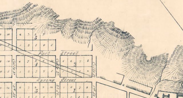
This not-always-reliable, 1929 map of 1871 LA shows Fort St stymied by the terrain. No. 29 marks what will become Poundcake Hill:
 http://memory.loc.gov/cgi-bin/query/...64l+pm000231))
The 1849 Ord survey agrees:
 http://www.lapl.org/sites/default/fi...ps/map0039.jpg
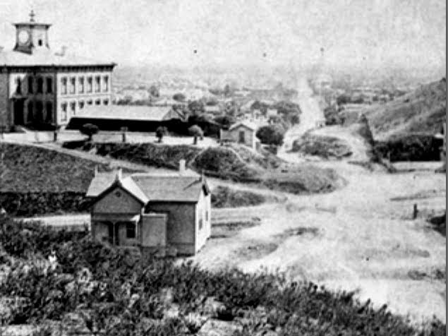
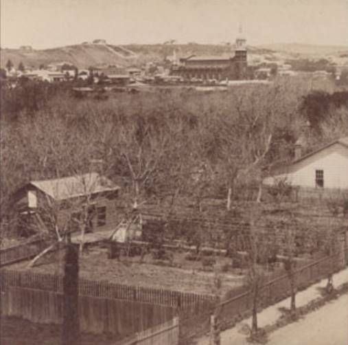
Early days. The cut is through to Sand St, just north of Temple. Poundcake Hill rises on the left. The "grade too steep for horses", on the right, is spilling onto unpaved Fort St. Note the little house on the brow of the hill at upper right. I like the three little hatches under the north eave. It turns up in photos of this site into the 1920s. I believe it was the first home built in this neighborhood. I used to know the name of the owner, but I've forgotten it now:

water & power
LAHS in place. circa 1873 or after. It must be spring. The little house's walled, east facing garden and the whole slope is lush with green:
 http://digitallibrary.usc.edu/cdm/si.../id/1729/rec/1
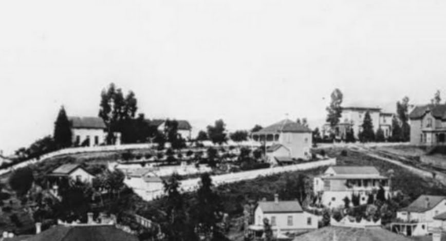
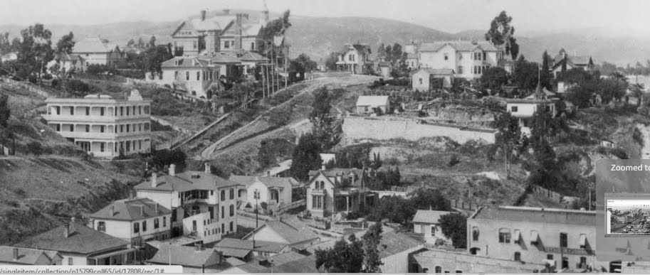
In this ca 1883 detail we see the Court Hill neighborhood as it looked then. The little house is on the left. Next is the single-story Bixby house, near the southeast corner of Court and Hill, as it looked when built in 1882. Just right of center is the Hopperstead home (1880) at 331 Court St. It was one story on its street frontage and two stories at the back to take advantage of the hill. A photo of the front is
here and a 1936 article about it
here.
On the southwest corner of Court and Hill is the lovely home of A.W. Potts, the County Clerk. There is an 1880 drawing of it at this
link. I do not know what possessed Mr Potts, but he demolished his nice house and built an enormous three-story mansion on the same site, which is on view in photos below. He subsequently sold it to Lewis L Bradbury who had the misfortune of dying in 1892. After a colorful, downward spiral, the mansion was demolished in 1929. The Bixby home, which got a second story and various extensions after it first went up, lasted until ca 1954.
Sarah Bixby Smith wrote in "Adobe Days" (1925), that the site for their house (in those days, the highest point in the city) was chosen,
"...because of the view and the sense of air and space. Below us was the little city, the few business blocks, the homes set in gardens on tree-shaded streets, the whole surrounded by orchards and vineyards. On clear days we could see the mountains far in the east and the ocean at San Pedro, with Catalina beyond" . During bad storms the Bixbys could also see houses floating down the river:
water and power (detail).
The houses on the crown of the hill in this ca 1885 detail are the Bradbury and the Bixby. There is a curious structure (or structures) built into the hillside below the Bixby house with many arches. It does not appear in any other photos I've seen. I assume it's stables:

water & power (detail)
The name "Fort Street" was changed to "Broadway" in 1890 by order of Mayor Hazard, at the request of property owners at Fort and Fourth.
Now with steps and some rather precarious-looking retaining walls. ca 1895. The Los Angeles Herald, "the Best Paper", is using a retaining-wall section as a billboard. They would like you to know that a month's subscription is only 80 cents. Note that the little house has rid itself of that cypress tree. It must have been ruining the view:
 http://digitallibrary.usc.edu/cdm/si...d/1740/rec/255
 zoomable
The 1889 WCTU temple stands on the northwest corner of Temple and Broadway. One can see the little house above its roofline with the Bixby house beyond it. I'm posting this photo because I was so struck by the fanciful houses built along Broadway, very different from the plain New England styles of the previous generation

water and power
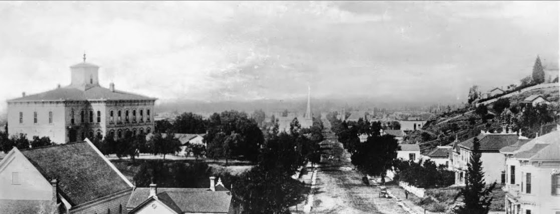
A great 1899 panorama from C.C. Pierce. More substantial buildings are in place on Broadway. One can just see the Hopperstead residence on the right margin. I wonder if Court Flight reused the northern flight of steps.

cc pierce
http://www.shorpy.com/node/7259?size=_original#caption zoomable
The Broadway cut looking south from above Temple in 1906. The little house, again, is on the right, looking very gnat-like compared to the court building. It looks as though it could easily fit inside the courthouse's clock tower:
 http://digitallibrary.usc.edu/cdm/si.../id/1725/rec/2
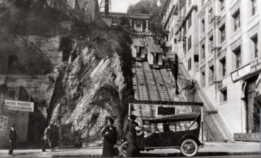
Court Flight and its staircase. The little house (left margin) is now overwhelmed by the new Stevens Apartments and the Court Flight Observation Tower:
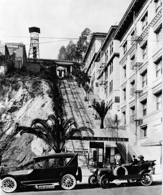
lapl previously posted by e_r
1924: The little house is still in place. This is the last photo I've found of it. The hillside looks like a big bubble in this view:

lapl (detail)
The very urbanized Fort St/Broadway cut in 1926. The entrance to Court Flight is hidden from view on the right between The New Broadway Hotel and the new-ish Law Building. On the east side of Broadway from north to south are the Hall of Justice, the grounds of the County Courthouse, the Hall of Records, The Times tower and old City Hall:
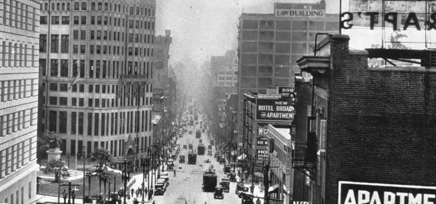 http://digitallibrary.usc.edu/cdm/si...id/1736/rec/38
 (detail)
The slope for sale. I imagine access would've been a bit iffy:
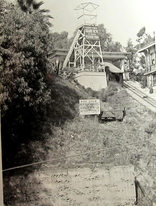
ebay, previously posted by e_r
A 1938 aerial showing the relationship between the slope and what's left of Poundcake Hill:

ebay (detail) previously posted by e_r
The slope being used as a dumping ground. The Law Building at left, Bixby home left-center, Stevens Apartments at center (parking for the Stevens is what replaced the little house) and The New Broadway Hotel, lower right:.

ebay (detail) previously posted by e_r
Court Flight abandoned, ca 1954. The stairs remain:

The bridge to the Law Building. The Bixby house has been cleared:

previously posted by gsjansen pg 239
1955: The neighborhood has been totally demolished. Workers load the hill itself into trucks to be hauled away, rather putting the lie to Gerald O'Hara's maxim. The west portal of the double-barreled Hill Street Tunnel (train bore, 1909 / street-traffic bore,1912) is still there for now. The huge excavation at left is for the soon-to-be-built Superior Court (1958). There's still a bit of traffic on the doomed stretch of Court Street :
 http://digitallibrary.usc.edu/cdm/re...oll44/id/55296
usc (detail) previously posted by HossC on pg 1103
May 10, 1955. That's the New Broadway Hotel on the right. The hill disappeared before the slope, as the demolition proceeded from west to east so as not to disturb the traffic on Broadway:

lapl previously posted by kznyc2k pg 655
The Law Building lasted until long after the hill was gone. The underground parking between the Superior Court and the HOA hasn't been topped with its park yet. The old Hall of Records looks like a ship that's become unmoored. With street realignment and the then-impending loss of the old Hall of Records, all vestiges of the old
Indian trail, which influenced Spring Street's route, was erased:
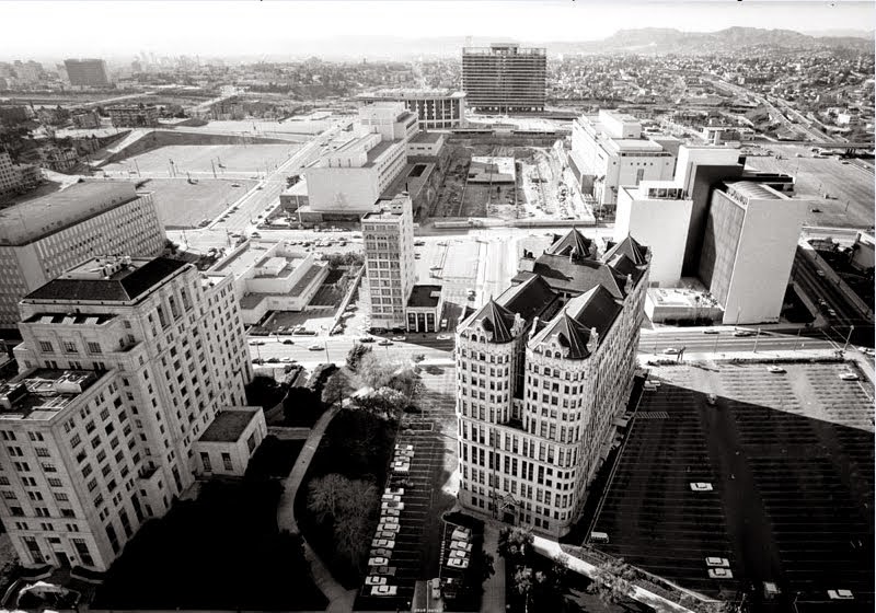
previously posted by sopas ej pg 1
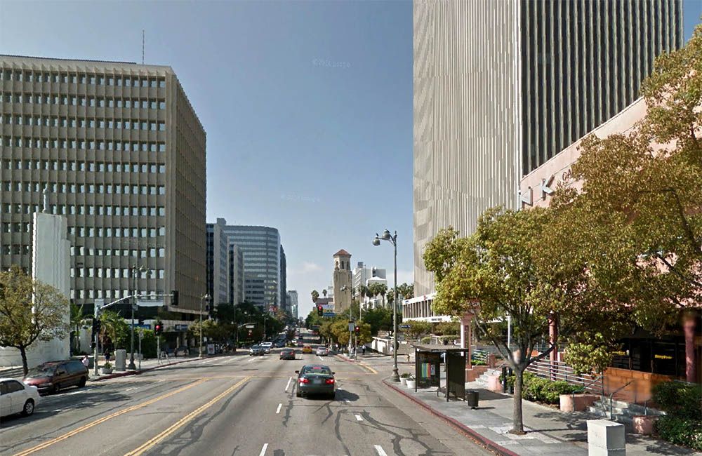
And, of course, again, now. One can still take a few stairs from Broadway to Hill. The Clara Shortridge Foltz Criminal Courts building is on the right, on what was once Poundcake Hill. No longer bustling or cozy, the area now looks like an architectural model on some forgotten CRA tabletop. I like how the city looks to the west, outside the planned area.
Sarah Bixby Smith wrote that,
"Court Street disappeared into a hollow at Hope, where a pond was made interesting by a large flock of white ducks" Maybe some ducks can be added to the moat at the DWP building:

google maps
One last look back at the little house, here in its 1899 glory days. Over the years, a southern wing, with porch and new chimney had been added, and a western extension. The three little hatches under the northern eave, each with a side-mounted, solid shutter, remain in place.

(detail)
http:http://www.shorpy.com/node/7259...iginal#caption
Another question: Sarah Bixby Smith writes in "Adobe Days" that her second Los Angeles home was the
"Shepard house", in the same neighborhood as the Bixby's third home at Court and Hill. She said that the lot in front of the Shepard house
"was very steep, with zig-zag paths and terraces." The house ended up "
...on top of the precipice made by the cutting of First Street between Hill and Olive". Harrison Gray Otis, I think, also lived in the Shepard house at one time (he had cousins named Shepard). Can anyone tell me more or provide a photo? Thx


 Prev
Prev


 I hadn't noticed that. Good eye CBD. Knowing that there was music playing makes it seem all the more fun.


 , a loss


 Linear Mode
