Here's a rapid transit history refresher excerpted from Light Rail Technology Overview & Analysis (PDF) (P.Topalovic/L. Lottimer/M. Pepito, City of Hamilton Public Works, April 2009):
Historical Context of Rapid Transit in Hamilton
Hamilton has a long history of rail use in passenger, commercial and industrial contexts. The first street car lines in North America were established in New York City during the 1830s. These inter-city rail networks enjoyed great success for many years until the popularity of the automobile began to compete with rail. By the 1950s, most street car networks were dismantled in favour of more flexible buses that were thought to alleviate congestion and decrease the cost of infrastructure associated with the streetcar (Taplin, 1998).
The Hamilton Street Railway was dismantled in 1951, in favour of trolley buses powered by overhead wires which, after 1992, were replaced by a bus-only transit network (Wyatt, 2007). At the height of rail passenger transit in the city there were four independently run lines connecting Hamilton’s inner city with Brantford, Dundas, Ancaster, Binbrook, Burlington, Stoney Creek and Niagara. These lines served innercity connections, such as the Hamilton Street Railway, and regional functions, such as the Toronto, Hamilton and Buffalo (TH&B) railway. Most lines travelled East-West along Main, King, York, Aberdeen and Lawrence road. They also ran North-South using Mountain Brow Boulevard and Beach Boulevard to Burlington.
The first mention of rapid transit in Hamilton can be found in a Hamilton Spectator Article from 1962 which states “If the city has built up a well-planned rapid transit system, mass transportation moves about smoothly to nurture development of the municipality. If only more buses and automobiles and commercial vehicles are crowded onto existing streets, it can strangle the city’s lifelines and end its growth” (Marshall, 1962).
A city report on transportation and transit from 1962 indicated that two North-South lines using James and Ottawa Streets were needed in addition to an East-West line running from Highway 102 (Hwy 403 bridge) to Hwy 20 (Centennial Parkway). For many years thereafter, the two types of systems that dominated transit planning discussions were subways and elevated rail tracks or monorails. Much of this speculation came from the building of Toronto’s Younge subway line in the 1950’s, the Disneyland Monorail and Seattle Monorail built for the 1962 World’s Fair.
Hamilton’s drive for rapid transit continued throughout the 1960s and 1970s, resulting in a variety of transportation studies which chose the North-South Corridor as the area of choice for rapid transit, because it was projected to have the highest population growth. This line would run from Mohawk Road and Highway 6 to the downtown core via Upper James Street and the Claremont Access, ending at Civic Square (Jackson Square). Another would run from Mount Albion to Barton Street and then onward to the core.
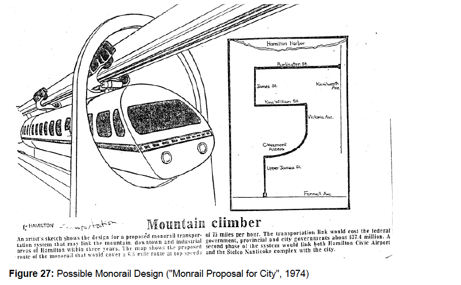
East-West Lines along Main and King from Main Street West (King’s Highway 2) to the downtown core were also considered important corridors. These three lines would all meet at the current site of the Hunter Street Terminal. While the technology was not specifically identified, proposals for monorail, subway and light rail transit systems were put forth. This lead to a 1974 plan for a monorail system, promoted by Mayor Victor Copps, which followed the North-South route while using Burlington Street to end at Kenilworth Avenue. It was projected that future expansion would link the airport and the Nanticoke Stelco Lake Erie Works to the downtown core.
The Ontario government’s urban transportation policy of the 1970s and their formation of the Urban Transit Development Corporation (UTDC), now the Advanced Rapid Transit (ART) division of Bombardier, enabled the province to fund, design and eventually build a system similar to the original Hamilton Transit Plan backed by Mayor Copps, referred to as ICTS (Intermediate Capacity Transit System). Hamilton was to be a test city for a new rail technology using driverless trains on elevated guideways, powered by linear induction motors and magnetic fields. The cost of the system was projected to be $100 million with 90% of the funding coming from the federal government and the province, who wished to promote a new technology that propelled the train using a middle track and positional wheels, rather than traditional rail methods. This system is currently running in Vancouver as the Sky Train and in Toronto as the Scarborough RT.
The proposed Hamilton Rapid Transit Project of 1981 looked at a variety of corridors connecting the upper escarpment with the downtown core including two tunnelling routes, one starting at Fennell Avenue and Upper James and ending at lower James Street; the other starting at Inverness and Upper Wellington and ending at the start of the Claremont access and the Jolley Cut. The other two routes were to be built above ground using elevated guideways. The preferred route, “W” (see Figure 30) was chosen to run from Mohawk Road to the core using a tunnel at James Street.
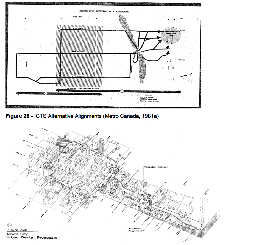
Figure 30 - Four Proposed ICTS Alignments (Metro Canada, 1981c)
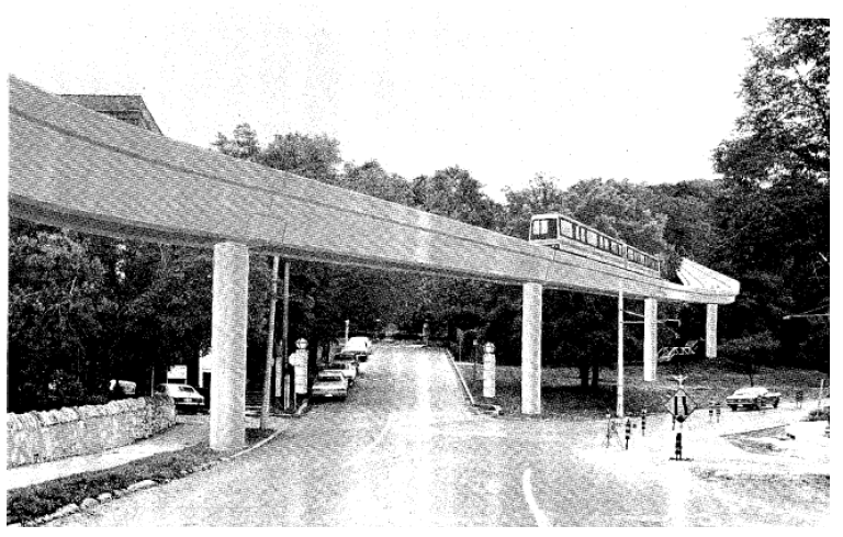
An example of the elevated guiderail and car can be seen in artist renderings of familiar Hamilton streetscapes. The first is a view of James Street South at the escarpment tunnel exit:
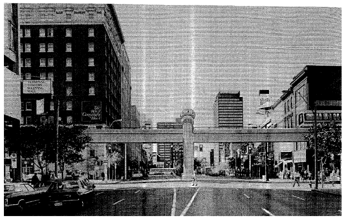
The second is at the Royal Connaught in the downtown core:
Proposed station stops included Upper James and Mohawk, Upper James and Fennell, St. Joseph’s Hospital, MacNab and King William Streets. The elevated track was to be a made-in-Hamilton design comprised of concrete in some areas and composite steel in others. Along the mountain corridor trains would travel along a median guideway carrying two way traffic, and a one-way looped guideway as they entered the central business district. Portions of the TH&B lands (at the present day GO terminal) were to be used as a maintenance facility. The full capital costs of the system were determined to be $111.1 million and operating costs were projected to be $3.5 million per year (Sicoli, 1981, June 17). Ridership estimates in peak hour traffic were 3,000 passengers per hour in 1986, and in 2001 they were projected to be 6,500 passengers per hour.
Early on in the transit planning process, during the 1970s, citizen and political support for the system was high; however as the more detailed planning and public consultation processes began in the 1980s, public opinion changed and support for the system dwindled, until the plans were eventually dropped in December of 1981. Some of the concerns included:
• Unsightly elevated guideways
• Negative impact on property values
• Burden on the taxpayer, especially due to unknown operating costs of the system (Rapid Transit Load Will Fall on City, 1981).
• Lack of political will, leadership and organization where rapid transit was concerned
• Improper timing and lack of need as transit needs are well served by bus routes.
• Population growth projections were too high.
• Coalitions of neighbourhood associations against the system.
• Reliance on un-proven, experimental technology.
• Insufficient access for the disabled.
• Traffic, emergency and personal safety hazards due to concrete guideways.
• The UTDC cars were to be made in Vancouver and not in Hamilton.
• Bus routes may still be required along ICTS routes since stations are too far apart.
• Bus routes require upgrading before money can be spent on new infrastructure.
• Does not service the proper areas such as the bayfront industrial core, which have a higher transit demand.
• Poor public engagement/consultation and an inability to answer to citizen concerns, coupled with reports of failure to provide accurate, unbiased reports on public opinion (Sicoli, 1981, Sept. 15).
• Distrust of the province’s intentions and the ability of the UTDC to deliver on their promises of prosperity and system functionality.
In addition to these concerns, Hamilton-Wentworth Regional transportation planners stunted the new transit system’s planning and installation by ranking it 8 out of 13 essential transportation projects for the city, far down the list from the top which contained mostly freeway projects including the Red Hill Valley and Lincoln Alexander Parkways (“Report Says No Urgency”, 1981). However, others believed that “rapid transit will be the thing of the future. We can’t keep constructing roads and carving up the escarpment for more automobile accesses.” (Scicoli, 1981, May 2).
While the UTDC was not interested in alternative technologies, some groups promoted more flexible streetcar systems, such as Edmonton’s light rail transit system. From the 1960s to the 1980s, ideas of transit options became more conservative and practical. Today, LRT dominates transit planning as the most promising and flexible option because of its ability to travel on street level, allowing for car and pedestrian crossings.
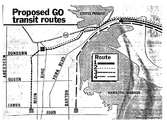
In 1982, the province proposed GO Advanced Light Rail Transit (GO-ALRT) improvement plans for the Oakville-Hamilton corridor. UTDC technology would provide the infrastructure and citizens had input on routing.
Three possible routes were identified as feasible. The first was the York Boulevard Elevated Option, where the train travels at ground level East of the CN tracks then is elevated along York Blvd. to a station between Hughson St. and Catherine St. at John St. In the second proposed route, the train travels at ground level west of Hwy. 403, then underground beneath the Hamilton cemetery and Woodbine street, emerging at Locke St. and running across an elevated guideway along York St. to the John St. station. The third proposed route runs at ground level East and North of the CN tracks, then rises over the tracks and runs on an elevated guideway up Ferguson Ave. and end at Wilson St. near James St. (Johnston & MacPhail, 1984).
Public opinion in this case was similar to that of the rapid transit plans two years earlier. In addition, much of the public wondered why a route utilizing the TH&B terminal and tracks was not being considered as feasible by the study team. In both the 1981 and 1983 rapid transit proposals, stakeholders with one-sided, specific agendas were quickly formed, the largest of which was COST (Coalition on Sensible Transit). In the late 1970s, evidence of increased economic and social development where light rail lines were installed was well documented and commonly understood by municipal planners, large businesses and others in the transit field. An examination of citizen letters in the Spectator from this time period shows a lack of interest in transit-oriented development and a focus on “Not In My Back Yard” politics (Martin, 1984).
A sizable portion of the public was opposed to the GO-ALRT preferred route along York St. and the Woodbine tunnel (under the Hamilton cemetery to Locke St.), but the plan was endorsed reluctantly by council. At the same time, the federal government created new legislation requiring existing rail corridors to be shared with commuter rail traffic. With this assurance the province opted to scrap GO-ALRT plans in favour for the conventional GO Transit system that is in place today. Currently, Hamilton has five GO-Train trips per day (a morning train to Toronto and four evening trains to Hamilton).
__________________
"Where architectural imagination is absent, the case is hopeless." - Louis Sullivan
Last edited by thistleclub; Jul 18, 2011 at 5:29 PM.
|


 Prev
Prev


 Linear Mode
