Transit Fantasies


Now we're back where we started. The other reason for the West End densifying is it being a part of downtown; again, it's just as much a destination as it is a throughfare. SkyTrain'd mean less people crowding the Burrard or Granville/Van Centre entrances or the 5 or 6, and less people on Georgia to/from the North Shore, because they're all getting on and off further out from the CBD.

Yeah, navigation is a nightmare. Doesn't mean we should make the area even less driveable without adding a better option. The Broadway light rail saved about five minutes over the 99 (ten minutes over the 9?) and naturally had much less people switching to transit as a result. Ditto the Portland Streetcar, where locals seem to agree that it's easier to walk or bike than to wait for it and ride the same distance; unless that's the objective, a tram doesn't seem to justify a 50% roadspace reduction by itself.


Technically, the City's jurisdiction is the Greenway and its ROW; once that's finished, they'll hand it off to TransLink. I know it's not possible for everybody, but attending an open house gives you a lot more information than just the PDFs and renders.
I wasn't asking you. I was asking who "the planners" he thought were going to manage the project. I know it's the CoV.

There is a better option being put in in this case though. The roadspace is parking. If it's ok to remove parking for a ped mall, it's ok to do that for a transit mall.

Why would (most) buses come across the LGB if there is Skytrain on Marine Drive? I don't even think it'd still be faster most of the time anymore.

I did actually add stuff regarding the Artubus Greenway on my original reply to you.

Only off-peak though. Point is, Davie is hardly a quiet street, otherwise we could just close it off to cars altogether.

Mathematically, a Marine Drive SkyTrain via Lonsdale or Second Narrows (as much as it's needed) isn't going to reach downtown from Park Royal or West Van faster than a LGB bus; Norgate or Cap Mall, maybe. Think of a Stanley Park Station as half of a second crossing.

Yup, and it vanished as soon as I hit "reply." Genuinely good timing.


Trust me, it’s coincidental. You replied, and I was going to reply to you, but I noticed you didn’t see the 2nd post, so I moved it back to the first post. It should be in the first post now.:sly:

From Park Royal to Waterfront, using the average speed of Skytrain and assumed 2min/transfer and the proposed Mid Harbour Commercial Drive Skytrain crossing, it’d be about 21min to Park Royal. Today, on the PM peak hour, the same would take an average of 30 min, +-5min on the LGB buses, depending on the bus transfer. Note that congestion of the LGB is relatively low today for ice reasons.

:shrug:

Off-peak, yes, but there’s that dumb person who doesn’t vacate the parking space and holds up traffic. What’s the alternative? Just keep the mixed traffic buses and have people walk to and from Georgia? Skytrain’s probably too expensive for 2 routes (maybe even 1) considering the circumstances, regardless of density and would be more effective for the medium distance routes it’s designed for.

Not to mention actual throughput of people and goods would be able to increase far beyond the 2-4 lane setup made right now.
 
Here is an alternate idea.
A9oKWaS.jpg
 
A Thurlow/Burrard spur should definitely be on the SkyTrain to-do list, even if it's at the back. Helps access to Davie as well.

From Park Royal to Waterfront, using the average speed of Skytrain and assumed 2min/transfer and the proposed Mid Harbour Commercial Drive Skytrain crossing, it’d be about 21min to Park Royal. Today, on the PM peak hour, the same would take an average of 30 min, +-5min on the LGB buses, depending on the bus transfer. Note that congestion of the LGB is relatively low today for ice reasons.

:shrug:

Off-peak, yes, but there’s that dumb person who doesn’t vacate the parking space and holds up traffic. What’s the alternative? Just keep the mixed traffic buses and have people walk to and from Georgia? Skytrain’s probably too expensive for 2 routes (maybe even 1) considering the circumstances, regardless of density and would be more effective for the medium distance routes it’s designed for.

Not to mention actual throughput of people and goods would be able to increase far beyond the 2-4 lane setup made right now.

Not saying you're right or wrong, but 16km divided by 45km/h gives me 22 minutes to Granville via Marine/Lonsdale/Expo (not including initial dwell time and two transfers), though it might improve with a Hastings Line. The 240 is a straight shot in, no transfers, and can be as short as 18-21 minutes depending on traffic; shorter if the line ends at the Stanley bus loop.

Sure, SkyTrain on Davie definitely isn't happening, but streetcars on Davie can't happen without additional SkyTrain; we need somewhere for the displaced commuters to go. Just tack a West End Extension onto the Hastings Line and reconfigure as necessary.

1/2 of the ridership on Broadway is headed to UBC/West Pt. Grey, meaning half the ridership is long-distance. The only thing like that here is Lions Gate, which is likely to be bypassed for the most part once Skytrain gets to the NS.


I mean, the Artubus was originally an S-Bahn of sorts ( a really terrible one, but :P)... But even considering that, they should be able to by minimizing the station # to the main centers only (Kerrisdale, Marine Drive, False Creek, Broadway, maybe Artubus Village and West Marpole.) So 2.6-1.77km/station on average.


They have?
As far as I know, they're suggesting sharing the ROW with pedestrians and cyclists, and none really seems to have any fences in place. I know the one Victoria 'active' rail line has fences separating it from the ped path on the same ROW. There should be space for something like that on most of the ROW, just the renderings never seem to include fences.

There's the other 1/2 of the ridership that's going to and from Central Broadway; 125,000 people in 2025 by TransLink's estimate. The West End'd get similar numbers on a weekday, let alone Pride Parade or fireworks night.
And I know SkyTrain's great, but it's not that great. Some people closer to the LGB are going to see it as an unnecessary detour (and some may be right, depending on the route), and a half-crossing can address that.

Maybe if they closed half the stations; they're envisioning it as a replacement of the 50 and 16 right now, with stops every ~400m.

See the dividing hedges? May not look like it, but they're definitely trying to minimize potential for collisions; ditto the suggestions of road closures.
 
Last edited:
Here is an alternate idea.
A9oKWaS.jpg

I'm not sure what this is trying to improve. Yes people keep thinking about a silly unprotected arbutus streetcar, but I don't see anyone but tourists wanting to use such a thing, as that's what happens everywhere else they exist. If you put it in a tunnel, there's nothing to see.

No, what should happen is that if this is intended for transit, just put a switch at Burrard (which is already a block from Robson) and send it back down towards Grandville Island, and make Burrard the transfer station.

And that can not happen because the trains are still stacked on top of each other at Burrard, and that's where the tunnel starts turning. Sure, yes a hole can be blown in the tunnel and we go from there, but there's no switch on the Expo line to do this. There's no switches between Stadium and Waterfront because they're all in the tunnel.

It's not advisable to build any at-grade surface transit on the downtown peninsula by virtue of it having too steep of a grade. That's why Grandville feels like you're on an escalator into hell, the tunnel is deep. An LRT on the downtown peninsula in a tunnel would be hell to get to, and slower than the Skytrain.

I still believe the Arbutus "greenway" is just going to be perpetually stuck as a greenway until someone decides to rip the bandaid off and build a subway underneath it when the Canada Line inevitably ends up overcapacity.
 
If Arbutus ever gets LRT/rapid transit, my fantasies of it always had it tunneling into downtown for a Burrard line there too.
 
My fantasy for this sort of scenario would be to, instead of Arubutus Line to waterfront parralleling the Expo Line, running the Expo Line to the North Shore straight from Burrard Station and having arubutus take over the tunnel from there to waterfront
 
(ahem)


Syncs up pretty well with the streetcar.
 
My fantasy for this sort of scenario would be to, instead of Arubutus Line to waterfront parralleling the Expo Line, running the Expo Line to the North Shore straight from Burrard Station and having arubutus take over the tunnel from there to waterfront
Eh. The issue is that doing that is an absolute pain. Ignoring all the stuff already there, the crossing there would need a massive detour to get around a large deep section in the middle of the Harbour unless you want to exit onto Harbourview instead of Lonsdale. http://skyscraperpage.com/forum/showthread.php?p=8372660

I'm not sure what this is trying to improve. Yes people keep thinking about a silly unprotected arbutus streetcar, but I don't see anyone but tourists wanting to use such a thing, as that's what happens everywhere else they exist. If you put it in a tunnel, there's nothing to see.

No, what should happen is that if this is intended for transit, just put a switch at Burrard (which is already a block from Robson) and send it back down towards Grandville Island, and make Burrard the transfer station.

And that can not happen because the trains are still stacked on top of each other at Burrard, and that's where the tunnel starts turning. Sure, yes a hole can be blown in the tunnel and we go from there, but there's no switch on the Expo line to do this. There's no switches between Stadium and Waterfront because they're all in the tunnel.

It's not advisable to build any at-grade surface transit on the downtown peninsula by virtue of it having too steep of a grade. That's why Grandville feels like you're on an escalator into hell, the tunnel is deep. An LRT on the downtown peninsula in a tunnel would be hell to get to, and slower than the Skytrain.

I still believe the Arbutus "greenway" is just going to be perpetually stuck as a greenway until someone decides to rip the bandaid off and build a subway underneath it when the Canada Line inevitably ends up overcapacity.
escalator into hell
I take it you've never been to Asia?

If this was for tourists, no one would even bother with crossing False Creek.
Here is an alternate idea.
A9oKWaS.jpg
I may be wrong, but this seems to just have the same problem as just building a Thurlow Skytrain Spur- the cost of boring a tunnel in the West End.

Also, it looks like the tunnel portal cuts off Fir Street...and West 4th, which is a big no-no.
A Thurlow/Burrard spur should definitely be on the SkyTrain to-do list, even if it's at the back. Helps access to Davie as well.


Not saying you're right or wrong, but 16km divided by 45km/h gives me 22 minutes to Granville via Marine/Lonsdale/Expo (not including initial dwell time and two transfers), though it might improve with a Hastings Line. The 240 is a straight shot in, no transfers, and can be as short as 18-21 minutes depending on traffic; shorter if the line ends at the Stanley bus loop.

Sure, SkyTrain on Davie definitely isn't happening, but streetcars on Davie can't happen without additional SkyTrain; we need somewhere for the displaced commuters to go. Just tack a West End Extension onto the Hastings Line and reconfigure as necessary.


There's the other 1/2 of the ridership that's going to and from Central Broadway; 125,000 people in 2025 by TransLink's estimate. The West End'd get similar numbers on a weekday, let alone Pride Parade or fireworks night.
And I know SkyTrain's great, but it's not that great. Some people closer to the LGB are going to see it as an unnecessary detour (and some may be right, depending on the route), and a half-crossing can address that.

Maybe if they closed half the stations; they're envisioning it as a replacement of the 50 and 16 right now, with stops every ~400m.

See the dividing hedges? May not look like it, but they're definitely trying to minimize potential for collisions; ditto the suggestions of road closures.
Here:
az8RDGp.png

based off http://skyscraperpage.com/forum/showthread.php?p=8372660
This is how I got my measurements. Yes, a lot of infrastructure, all of which are however, higher priority.
Yep, and it'd be on the back. We'd be getting a relief line to the Canada or Expo before we get it.

I never said it would kill the LGB buses entirely. There is a small niche even with Skytrain (West Van-West End/Stanley Park).

And bus lanes don't improve road capacity?

Ok, yeah, now that I've done some more digging, yeah, they do seem to do that. Not exactly sufficient for high-speed, since that definitely isn't the goal. Still a shame to do something you could do with BRT on Arbutus Street on a heavy rail corridor. I don't think anything of that sort (possibly not even the streetcar) could even happen anyways as long as it's a COV-controlled project, unless the NPA still has streetcars as their pet project.
 
Last edited:
Eh. The issue is that doing that is an absolute pain. Ignoring all the stuff already there, the crossing there would need a massive detour to get around a large deep section in the middle of the Harbour unless you want to exit onto Harbourview instead of Lonsdale.

He probably means to continue from Burrard to Denman, Stanley Park then direct to Park Royal.

If this was for tourists, no one would even bother with crossing False Creek.
I agree with you here.

Also, it looks like the tunnel portal cuts off Fir Street...and West 4th, which is a big no-no.

It will cut and cover under 4th ave. Because it is LRT and a conventional motor it will need a longer approach to dive underground.
 
Here:
This is how I got my measurements. Yes, a lot of infrastructure, all of which are however, higher priority.
Yep, and it'd be on the back. We'd be getting a relief line to the Canada or Expo before we get it- and I'm saying that as the one who suggested it first here.

I never said it would kill the LGB buses entirely. There is a small niche even with Skytrain (West Van-West End/Stanley Park).

And bus lanes don't improve road capacity?

Ok, yeah, now that I've done some more digging, yeah, they do seem to do that. Not exactly sufficient for high-speed, since that definitely isn't the goal. Still a shame to do something you could do with BRT on Arbutus Street on a heavy rail corridor. I don't think anything of that sort (possibly not even the streetcar) could even happen anyways as long as it's a COV-controlled project, unless the NPA still has streetcars as their pet project.

That assumes a Hastings SkyTrain before a Lonsdale one; if not, you're using the Expo or the R5, which'll extend the overall commute way past 21 minutes.
There's been plenty of people suggesting West End SkyTrain before you, and there will be after you, and there's plenty of political and economic demand to back it up - it's absolutely not just local residents using the beaches and parks and villages. It's not priority one, but the worst case is ten years after the Hastings Line. Definitely ahead of 41st.

Assuming that people use the bus - and they do - then bus lanes most definitely add capacity. My question, as with Broadway, Surrey, et al, is whether that capacity is enough for future demand, or if we're just going to end up in the same place if/when street transit overcrowds and everybody else is driving on less, harder-to-use roadspace. That's going to happen faster downtown than anywhere else.

---

Well yeah, even the Eglinton-Crosstown in Toronto can only average 27 km/h, but that's still a damn sight better than the other ideas we've come up with.

The advantage of an off-street tram is that it doesn't have to worry about intersections or all the related signals and space conflicts. Couple that with side street closures (also pitched at the open houses) and you're closer to 27 than most other projects.
 
So is Skytrain to Lander and Horseshoe Bay.:shrug:

Ok, Yeah, I'll delete that part of my post. Could you please delete your parts relating to it and forget this thread of the discussion never happened?

Come on, the West End is hardly Ladner! It's at least on the same level as Lonsdale or Willingdon.

Done; apologies if you took the previous one the wrong way.
 
Come on, the West End is hardly Ladner! It's at least on the same level as Lonsdale or Willingdon.

Done; apologies if you took the previous one the wrong way.
Yep. Point is, "People want something" is kind of a fallacy.
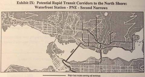
Relevant to the Hastings - North Shore discussion:

The Hastings SkyTrain alternate reality.
https://orangeraisin.wordpress.com/2019/12/25/hastings-skytrain-alternate-reality/

vancouver-north-shore-transit-options-1994-second-narrows.jpg

Source: North Shore Transit Options, BC Transit, 1994.
https://orangeraisin.wordpress.com/2019/12/25/hastings-skytrain-alternate-reality/
Hey, thanks, it was a reply to me too!
He probably means to continue from Burrard to Denman, Stanley Park then direct to Park Royal.

I agree with you here.


It will cut and cover under 4th ave. Because it is LRT and a conventional motor it will need a longer approach to dive underground.
Yeah, but that's the tunnel portal part. Just move it to earlier in the line and avoid any potential road conflicts.
That assumes a Hastings SkyTrain before a Lonsdale one; if not, you're using the Expo or the R5, which'll extend the overall commute way past 21 minutes.
There's been plenty of people suggesting West End SkyTrain before you, and there will be after you, and there's plenty of political and economic demand to back it up - it's absolutely not just local residents using the beaches and parks and villages. It's not priority one, but the worst case is ten years after the Hastings Line. Definitely ahead of 41st.

Assuming that people use the bus - and they do - then bus lanes most definitely add capacity. My question, as with Broadway, Surrey, et al, is whether that capacity is enough for future demand, or if we're just going to end up in the same place if/when street transit overcrowds and everybody else is driving on less, harder-to-use roadspace. That's going to happen faster downtown than anywhere else.

---

Well yeah, even the Eglinton-Crosstown in Toronto can only average 27 km/h, but that's still a damn sight better than the other ideas we've come up with.

The advantage of an off-street tram is that it doesn't have to worry about intersections or all the related signals and space conflicts. Couple that with side street closures (also pitched at the open houses) and you're closer to 27 than most other projects.
I refuse to call it the R5.

Going on Davie? You're the one who said there wasn't enough demand for artics... And on Robson/Georgia/Coal Harbour? That depends.

RRT has a tendency to attract a lot of users.

The Broadway stops only for LRT1 only have a total use of 1904 pphpd and BRT1 gets 3304pphpd. For RRT1? 8590pphpd. Skytrain tends to be good at attracting riders, big shocker there. Though, TBF, I'd imagine there's more people using it to transfer to Canada, so removing Cambie gets 4233pphpd for RRT. All by 2041.

2 min frequency, Articulated BRT gets you to 3000pphpd- without any need for biartics (30% capacity improvement in exchange for wider lanes for turning or greater automation/precision to compensate) or trying to use greater automation (up to ~1min min. headway, from the BRT Standard, though probably optimistic w/o passing lanes) to get the frequency up. Let's say it can be expanded to 1min30 frequency and biartics. That's 5850pphpd for an absolute maximum, probably enough to last us as long as long as the Canada.
The cost is also $30M/km, so set-up cost is pretty low, closer to the Gondola than anything else.

We could actually have a real intermediate capacity transit system.
Well yeah, even the Eglinton-Crosstown in Toronto can only average 27 km/h, but that's still a damn sight better than the other ideas we've come up with.
Excuse me, but I'm not sure that's 100% relevant here. Elington has a stupid # of stations, underground or not. It has a denser station spacing than the B-lines for crying out loud!

My problem is that I don't think 27 is enough.
Especially since the line is fairly curvy. 60 would be nice, comparable to the 555 and the WCE.
To get that, you have to be working on different assumptions and goals than the tram idea.
 
Last edited:
Yep. Point is, "People want something" is kind of a fallacy...

... Going on Davie? You're the one who said there wasn't enough demand for artics... And on Robson/Georgia/Coal Harbour? That depends.

RRT has a tendency to attract a lot of users.

The Broadway stops only for LRT1 only have a total use of 1904 pphpd and BRT1 gets 3304pphpd. For RRT1? 8590pphpd. Skytrain tends to be good at attracting riders, big shocker there. Though, TBF, I'd imagine there's more people using it to transfer to Canada, so removing Cambie gets 4233pphpd for RRT. All by 2041.

2 min frequency, Articulated BRT gets you to 3000pphpd- without any need for biartics (30% capacity improvement in exchange for wider lanes for turning or greater automation/precision to compensate) or trying to use greater automation (up to ~1min min. headway, from the BRT Standard, though probably optimistic w/o passing lanes) to get the frequency up. Let's say it can be expanded to 1min30 frequency and biartics. That's 5850pphpd for an absolute maximum, probably enough to last us as long as long as the Canada.
The cost is also $30M/km, so set-up cost is pretty low, closer to the Gondola than anything else.

We could actually have a real intermediate capacity transit system

Excuse me, but I'm not sure that's 100% relevant here. Elington has a stupid # of stations, underground or not. It has a denser station spacing than the B-lines for crying out loud!

My problem is that I don't think 27 is enough.
Especially since the line is fairly curvy. 60 would be nice, comparable to the 555 and the WCE.
To get that, you have to be working on different assumptions and goals than the tram idea.

If public demand and politics wasn't a thing, the Evergreen and Surrey extensions wouldn't even have been considered, much less the North Shore's. Pretty sure that increased coverage of downtown is at least near or on that level.

Not with the current setup, no. But we're talking about future demand after removing half of Davie and Robson and possibly Pender/Dunsmuir's road capacity, and that's a much different equation.
Finally found the stupid graphic (page 277). Overall demand for Cambie-Arbutus is ~1,600-3,800 WB in 2041; doubled (for lack of an EB graph), that's as much as 7,600. I'd argue strongly that the West End, especially with an event on, is just as much in-demand as UBC by 2041, if not already.

---

Relevant or not, 27-28.5 average (sources are conflicted) is the kind of medium-capacity speed we should be expecting on the Greenway. 60 top is too fast for everything north of 49th, and 60 average is faster than the SkyTrain!

Besides, seeing as Surrey was aiming for 21, I think we're good.


Back
Top