noirish Los Angeles


Status
Not open for further replies.
'Flaming torches' courtyard apts. 1200 block S. Mariposa


That is a fantastic set of buildings. All three have a build date of 1926, according to the County Assessor's office. It has sort of an Egyptian feel and may have been inspired
by the King Tut discovery in 1922.

:previous: Very interesting. Thanks for the information oldstuff.


Here is a courtyard apartment on the 1400 block of S. Bonnie Brae that I've had my eye on for years, but for some reason or other never posted about it.
oldstuff's comment about the King Tut discovery, immediately reminded me of this unique rental.


GSV

oldstuff, could you look it up at the County Assessor's office to establish a date? Surely this was built during, or soon after, the Egyptian craze.


below: The Egyptian symbol above the front entrance.


matches almost perfectly

http://api.ning.com/files/gQ3x6jszW...heAncientEgyptianWingedSunDiskSymbolTitle.jpg


below: Here is a slightly different angle, that also shows the two fine buildings to the north of the low-slung courtyard apt.


GSV


A closer view of the neighboring apartments to the north. (I especially like the twin cartouches with wooden slats for vents)


GSV


I don't want to go too crazy with the street views, but I'll add one more. ;)
I just couldn't leave out this very nice apartment on the other side of the 'Egyptian' courtyard apt.(to the south)


GSV


aerial / you can see the long narrow 'Egyptian' courtyard in the center.

google earth
___________

Thanks oldstuff and ReDSPork02, for your help in locating my mystery building. I was thrown by the colors.
Was the Post Office Annex ever Blue? -or were the colors in my slide messed up?
 
Last edited:
They really expose what a mass of rough, rolling geography the center of Los Angeles really is and was.

la%20hills_zps6f2uesqo.jpg

Previous on this thread.

Rolling maybe, but not "rough". Our hills were very gentle. But once they started hacking at them, they became unstable cliff-faced piles of earth which had to be erased for safety's sake, if for no other reason. The die was cast, of course, with the Ord Survey. Streets were laid out as if the hills didn't exist. I don't know if Ord took his instruction from the Common Council or made decisions on his own, but Bunker Hill was doomed before it was named.

Fullscreen%2Bcapture%2B362015%2B63634%2BPM.jpg

lapl

It may have seemed like a good idea at the time, but the work stretched on from 1874 (or before) for more than one hundred years. Each removal causing the need for another one until Bunker Hill was just a slightly elevated mesa, wider than it was originally with plenty of newly valuable real estate on top.


Thank you Michael for the reminder re Lake Shore Avenue. I do know, but a little reinforcement never hurts.

NLA has discussed Egypt-mania (re architecture) before. Here's just one post
 
Last edited:
The California Furniture Co at 639-645 S Broadway. The seller says there's a 1908 postmark, but only included a picture of the front. I found a listing at that address in the 1909 CD.

LACaliforniaFurnCo.jpg

eBay

The clipping below is from the October 15, 1905 edition of the Los Angeles Herald. It announces the grand opening of the new six-story building.

LACaliforniaFurnCo2.jpg

California Digital Newspaper Collection

The July 19, 1910 edition of the Los Angeles Herald contains this story about the company's bid of nearly $250,000 to furnish the Hall of Records being accepted.

LACaliforniaFurnCo3.jpg

California Digital Newspaper Collection

The California Furniture Co didn't stay in their new building for very long, because by 1911 they had moved across the street to 644 S Broadway (the 1915 CD lists the address as 644-646 S Broadway). Here's the store in 1929, just on the far side of Boos Bros Cafeteria.

LACaliforniaFurnCo4.jpg

LAPL

The company's entry in the 1932 CD is headed "California Furniture Co (See W & J Sloane)". I looked up W & J Sloane and found "Sloane W & J. Owners of California Furniture Co, Oriental Rugs, Domestic Rugs, Carpets, Imported Furniture, Mastercraft Furniture, Fine Fabrics and Draperies, Interior Decoration, 644 S Broadway". It looks like W & J Sloane had moved to 3258 Wilshire Boulevard by 1936, and the old store at 644 S Broadway had become Brooks Clothing Co.
 
not to beat a dead horse, but


:previous: In all the recent photographs showing earth removal and man-made 'cliff's', I haven't seen one rounded smooth orb
like the numerous orbs we saw in my Sunset Blvd. photograph of 1912. Not one.

Do you guys still think they were boulders?

Here's the 1912 photograph, if anyone wants to look at it again. ;)
http://forum.skyscraperpage.com/showpost.php?p=6939606&postcount=26731
__
I think this video shows where some of the boulders have been removed. I see a few holes in the dirt wall. Could be my imagination...who knows. Needs to be inspected in person...maybe by googlemobile.

https://youtu.be/szlrNfuRVb0
 
Rolling maybe, but not "rough". Our hills were very gentle. But once they started hacking at them, they became unstable cliff-faced piles of earth which had to be erased for safety's sake, if for no other reason. The die was cast, of course, with the Ord Survey. Streets were laid out as if the hills didn't exist. I don't know if Ord took his instruction from the Common Council or made decisions on his own, but Bunker Hill was doomed before it was named.

Fullscreen%2Bcapture%2B362015%2B63634%2BPM.jpg

lapl

It may have seemed like a good idea at the time, but the work stretched on from 1874 (or before) for more than one hundred years. Each removal causing the need for another one until Bunker Hill was just a slightly elevated mesa, wider than it was originally with plenty of newly valuable real estate on top.


Thank you Michael for the reminder re Lake Shore Avenue. I do know, but a little reinforcement never hurts.

NLA has discussed Egypt-mania (re architecture) before. Here's just one post

The area within the center of LA is so rough they had to have the steep Angel's Flight, Court Flight and several tunnels to traverse the city with any ease. I guess we just see it differently.

 
clearly mislabeled on eBay


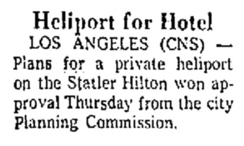
Could this finally be the long-sought-after proof that the Statler Hilton had a helipad?


http://www.ebay.com/itm/Original-19...439?pt=LH_DefaultDomain_0&hash=item5b0e4125a7

In the distance..........the Brown-Leigh Apartments....the Hotel Victor...


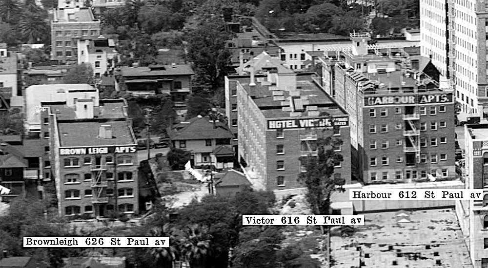
below: I found the Hotel Victor in the 1956 directory. 616 St. Paul Avenue


LAPL


google-earth

Then it dawned on me....is the helicopter taking off from the roof of the Statler Hilton!?
___________


I posted this matchbook several months ago.

eBay

...but none of us could find any proof of a working helipad.
__
 
Last edited:
Dinosaur Eggs

not to beat a dead horse, but


:previous: In all the recent photographs showing earth removal and man-made 'cliff's', I haven't seen one rounded smooth orb
like the numerous orbs we saw in my Sunset Blvd. photograph of 1912. Not one.

Do you guys still think they were boulders?

Here's the 1912 photograph, if anyone wants to look at it again. ;)
http://forum.skyscraperpage.com/showpost.php?p=6939606&postcount=26731
__

Your bringing this up again finally flogged my memory about this phenomenon. I remember reading some years back that at the time they were popularly believed to be dinosaur eggs!

Here's a link to a Google Books excerpt that gives a bit of detail:

https://books.google.com/books?id=u7qkglM24OsC&pg=PT398&lpg=PT398&dq=dinosaur+eggs+sunset+blvd&source=bl&ots=ncEISIIHzX&sig=Ac-NKP2kkF5JCTuQiW3OMm5YhIg&hl=en&sa=X&ei=21AKVcS7NoHZggS-i4LgDQ&ved=0CC8Q6AEwAw#v=onepage&q=dinosaur%20eggs%20sunset%20blvd&f=false
 
Last edited:


Prohibition Ends! :cheers::cheers::cheers:

1933 - Beer becomes legal at Belmont Grill 464 S. Main. Pershing Hotel, 502 S. Main Street.
00100926.jpg

00100927.jpg
Lapl


1933 - Malamute Bar opens after repeal of Prohibition. Address Unk.
00011851.jpg
(See also http://forum.skyscraperpage.com/showpost.php?p=5355435&postcount=4286 )


April 17, 1933 - Eastside Brewery, located at 1920-2026 E. Main Street in Lincoln Heights.
00100928.jpg


April 1933 - Celebrate end of Prohibition at Eastside Brewery, 1920-2026 E. Main Street in Lincoln Heights with Jean Harlow, Walter Huston, and brewery manager, Charles J. Hick.
00100925.jpg
Lapl


Los Angeles Brewery aka Eastside Brewery


00074995.jpg
Lapl


Focusing on Jean Harlow, it is somewhat laughable that the source fails to identify this icon, although it names her somewhat easier to forget counterparts. In any case, the next three photos appear to be from the 1933 National Air Races at Mines Field. Jean looks like she knew how to enjoy herself.

1.gif
http://www.air-racing-history.com/images3/1.gif

Jean and San Fran Pilot Ray Moore
ajaxhelper
ajaxhelper

ajaxhelper
ajaxhelper
http://digitallibrary.usc.edu/cdm/compoundobject/collection/p15799coll170/id/44299/rec/2


Jan Heuks and Jean
ajaxhelper
ajaxhelper

ajaxhelper
ajaxhelper


1933 -
Jean Harlow posed on a 1932 Auburn Boat-tailed Speedster along with race organizer Cliff Henderson. The photo was taken at the 1933 National Air Race held at Mines Field, now the site of LAX.
Mines_Field_1933.jpg
http://waterandpower.org/4%20Historic%20Photos%204/Mines_Field_1933.jpg


Jean and Packard in front of her Beverly Hills residence
8264843_orig.jpg
http://josephgreco.weebly.com/uploads/1/7/3/2/1732235/8264843_orig.jpg
a.jpeg
http://www.flipanimation.net/FLIP4/a.jpeg


Windswept Jean
8ac2f2ee6ec19c5c14b08782cffbfcca.jpg
http://1.bp.blogspot.com/-g-Fd9YBoo0c/UWH9YMt2eDI/AAAAAAAABaU/Kw4lTCSE-mQ/s1600/8ac2f2ee6ec19c5c14b08782cffbfcca.jpg

Jean in her '32 Packard. Don't text and drive.
9766164_orig.jpg
http://josephgreco.weebly.com/uploads/1/7/3/2/1732235/9766164_orig.jpg


1933%20Los%20Angeles%20Air%20Races%20Poster%20Print%2050.jpg
http://speedwayposters.com/store/images/1933%20Los%20Angeles%20Air%20Races%20Poster%20Print%2050.jpg


Evidently, Jean struck a posed for the '33 National Air Race Trophy:shrug:
3753a_lg.jpeg
http://rmyauctions.com/ItemImages/000003/3753a_lg.jpeg

3753b_lg.jpeg
http://rmyauctions.com/ItemImages/000003/3753b_lg.jpeg


ae2bb11ea0a47dd1d535b25ddbd97036.jpg
https://s-media-cache-ec0.pinimg.com/736x/ae/2b/b1/ae2bb11ea0a47dd1d535b25ddbd97036.jpg


la_races_0.jpg
http://blog.modernmechanix.com/mags/ModernMechanix/9-1933/la_races/la_races_0.jpg
 
Last edited:
The area within the center of LA is so rough they had to have the steep Angel's Flight, Court Flight and several tunnels to traverse the city with any ease. I guess we just see it differently.


Yes, CBD we are seeing it differently, which is good. I have my romantic wish that Bunker Hill had been kept unbuilt as a public amenity as New York did Central Park. As I said before, I don't mind the tunnels and an incline railway or two might have worked out depending on the design. The Olmsteds would have had fun with it. I would have been happy with paths and a few oaks dotted about. (Court Flight's steep slope was caused by the Fort Street cut and Angels Flight's by the grading away of the lower slope to put in Hill Street). There would have been less salable real estate, but with all our sprawl, we never seem to lack for land anyway.

All blood under the bridge now (as a friend used to say), but it's still fun to think about the "if onlys" :-)

Fullscreen%2Bcapture%2B362015%2B63634%2BPM.jpg

lapl


Your bringing this up again finally flogged my memory about this phenomenon. I remember reading some years back that at the time they were popularly believed to be dinosaur eggs!

Perfect! Now there's an answer that should satisfy everybody. I'm a believer :-)
 
Last edited:
Regarding the "Malamute," reputed to have been the first saloon to open in Los Angeles after Prohibition's repeal, I question the source of this assertion. It is true that LA had more than it's fair share of novelty restaurants, but that doesn't guarantee that all themed restaurants were located in the city limits. The previously posted images strike me as having been located just as easily at or near a boardwalk as once might have existed at or near Ocean Park or the Long Beach Pike. :shrug:


6a00d83451bdba69e20128778d7750970c-800wi
http://drx.typepad.com/.a/6a00d83451bdba69e20128778d7750970c-800wi


The Pike, Edit: 1936, according to one source http://www.millikanalumni.com/Pike/PikeHistory.html
SHC-at-LB-Pike-1936-1.jpg
http://www.millikanalumni.com/Pike/images/SHC-at-LB-Pike-1936-1.jpg


Pike Postcard
pike1.jpg
http://www.scripophily.com/webcart/vigs/pike1.jpg
 
Last edited:
clearly mislabeled on eBay

Could this finally be the long-sought-after proof that the Statler Hilton had a helipad?


http://www.ebay.com/itm/Original-19...439?pt=LH_DefaultDomain_0&hash=item5b0e4125a7

In the distance..........the Brown-Leigh Apartments....the Hotel Victor...

I posted this detail which includes the Brownleigh/Brown Leigh Apartments and the Victor Apartments back in December 2013, but since I failed to name any of the apartment buildings in the text, they won't show up in searches. The picture also includes the Harbour Apartments.

Near the center of the Cityscape, and not far from the houses on Wilshire, is St Paul Avenue. I used the 1929 CD to find the addresses of three of the St Paul Avenue buildings.

LAStPaulAv.jpg

Detail of photo in USC Digital Library/rescarta.lapl.org

The Brownleigh Apartments appear in the 1972 movie 'Hickey & Boggs'. At least some of the interior shots were filmed on location as well. Here's the front of the building on St Paul Avenue.

LAHickeyBoggs1.jpg

MGM

Bill Cosby and Robert Culp hiding on the Harbor Freeway side.

LAHickeyBoggs2.jpg

MGM

I'm guessing that must be the Victor with the "Single Apartments" sign. The site of the little house from the Cityscape seems to be a parking lot.

LAHickeyBoggs3.jpg

MGM

A view up St Paul Avenue.

LAHickeyBoggs4.jpg

MGM

St Paul Avenue today.

LAHickeyBoggs5.jpg

GSV
 
'Flaming torches' courtyard apts. 1200 block S. Mariposa


:previous: Very interesting. Thanks for the information oldstuff.


Here is a courtyard apartment on the 1400 block of S. Bonnie Brae that I've had my eye on for years, but for some reason or other never posted about it.
oldstuff's comment about the King Tut discovery, immediately reminded me of this unique rental.


GSV

oldstuff, could you look it up at the County Assessor's office to establish a date? Surely this was built during, or soon after, the Egyptian craze.


below: The Egyptian symbol above the front entrance.


matches almost perfectly

http://api.ning.com/files/gQ3x6jszW...heAncientEgyptianWingedSunDiskSymbolTitle.jpg


below: Here is a slightly different angle, that also shows the two fine buildings to the north of the low-slung courtyard apt.


GSV


A closer view of the neighboring apartments to the north. (I especially like the twin cartouches with wooden slats for vents)


GSV


I don't want to go too crazy with the street views, but I'll add one more. ;)
I just couldn't leave out this very nice apartment on the other side of the 'Egyptian' courtyard apt.(to the south)


GSV


aerial / you can see the long narrow 'Egyptian' courtyard in the center.

google earth
___________

Thanks ReDSPork02, for your help in locating my mystery building. I was thrown by the colors.
Was the Post Office Annex ever Blue? -or were the colors in my slide messed up?

The Los Angeles County Assessor has a build date on the Egyptian court as 1925. There are 10 apartment on the property and there is no "remodeling" date which would indicate that it has been left pretty much alone since 1925
 
Status
Not open for further replies.


Back
Top