noirish Los Angeles


Status
Not open for further replies.
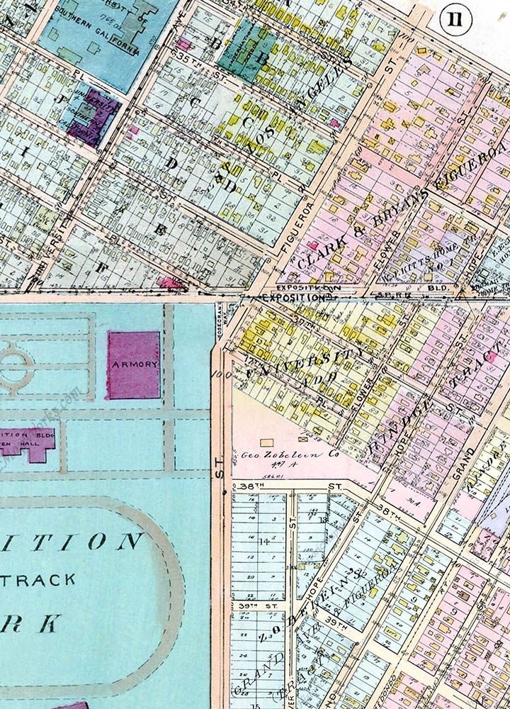
My follow-up post included this stitching together of four Baist maps to show the extent of the Zobelein property in 1921, along with a few other details. The property is also labeled with George Zobelein's name on the 1914 Baist map, but there's no name there on the 1910 map, and the area below 38th Street is just labeled "Grand Ave & Figueroa Tract" (no "Zobelein's").
LAZobeleinMap.jpg

Thank you so much HossC, I apologize for not noticing your follow up on the Zobelein property.

The Baist map is fascinating. No triangle for Carl's yet.

The area marked "Zobelein" north of 38th plus the "Zobelein's Grand Ave and Figueroa Tract" south of 38th St make a rather grand triangle themselves along Figueroa.

Would these two combined properties approximate 350 acres, or do you think parcels were sold off before the date of the map?

And , LOL, there's an adjoining "Rindge Tract". Those Rindges were everywhere. I like them too.
 
"Beauty Parade, Venice Ca."


It took me a moment to realize the 'girl' on the right is a papier-mâché hood ornament.
I believe the emblem on the car says Jordan (?) with an arrow head (?)

I like the guys (and the sailor) hanging onto the building trying to get a better view.

__
 
:previous: Thanks Hoss. I wonder what the red neon on the front of the Fine Arts Building is advertising?
_____


below: I just came across this snapshot on eBay.

"A 1919 photo of a street car going down the street and turning a corner in Los Angeles California."


http://www.ebay.com/itm/PACIFIC-ELE...904?pt=LH_DefaultDomain_0&hash=item1c4f96d770

Any idea what's going on with the cement 'barricades' that appear to be in the middle of the street?

__

I don't know why this couldn't be Los Angeles. I'm assuming "cement is the clue", not "glue" was offered but there was plenty of cement in L.A. As for what these are doing in the middle of the street they're not. They are marking off a parking space. You can see the car parked in the space next to the cordoned off area. The streetcar is turning from a street dead ending into another.
 
Last edited:
I couldn't resist posting this slide of the Warner's Theatre at 7th and Hill - be sure to scroll right. The seller dates it at June 1958.
By a strange coincidence, I watched the DVD of the movie being shown only a few days ago, so I recognized it just by the lead
actors' names (it's 'The Bridge on the River Kwai').

LAWarners7thHill.jpg~original

ebay

Can someone please explain the logo above William Holden's name? The "W" is a mirror-image of the current Warner Bros' "WB" logo,
and the shield is the same, but it says "SW". Was this normal on their theaters, or am I missing something?
 
Can someone please explain the logo above William Holden's name? The "W" is a mirror-image of the current Warner Bros' "WB" logo,
and the shield is the same, but it says "SW". Was this normal on their theaters, or am I missing something?

The Warner Brothers bought the Stanley Company of America in 1928 to get hold of their chain of theaters. The logo may be left over from that...

...or was, for a time anyway:
Fullscreen%2Bcapture%2B3132015%2B125823%2BPM.jpg

http://cinematreasures.org/theaters/491
 
Last edited:
Mystery Logo...SW

The Warner Brothers bought the Stanley Company of America in 1928 to get hold of their chain of theaters. The logo may be left over from that...

...or was, for a time anyway:
Fullscreen%2Bcapture%2B3132015%2B125823%2BPM.jpg

http://cinematreasures.org/theaters/491

That SW didn't last long because its gone by 1960, photo below. The photo above is from 1954 and its not seen. So the SW was on the marquee for a very short time.
I'm not sure how the Stanley company figures into the scene at that late date. I see that SW in only one photo of the theater....1958. Nothing makes sense..... any answers?.


warners%201960lace_zpsraidf0zg.jpg

Historic LA theaters.

Ref: https://sites.google.com/site/downtownlosangelestheatres/warner_downtown
 
Last edited:
That SW didn't last long because its gone by 1960, photo below. The photo above is from 1954. So the SW was on the marquee for a very short time.
I'm not sure how the Stanley company figures into the scene at that late date. Any answers?.


warners%201960lace_zpsraidf0zg.jpg

Historic LA theaters.

The theater, with a blank shield, in the photo above, is from after it was bought by Metropolitan and renamed the "Warrens" (note the blade sign).

Maybe "SW" was the logo for Warner's theater division, even though Stanley was old history? But, I cannot explain why "WB" was used in '54 & "SW" in '57
 
:previous:

I'm glad it's not just me who's confused by this. Of course the shield is still there, but now has a diamond in it.

LAWarners7thHill2.jpg

GSV
 
I'm glad it's not just me who's confused by this. Of course the shield is still there, but now has a diamond in it.

Google kept wanting to tell me about the Stewart-Warner Company, which also used an "SW" logo. I doubt there's a connection.

PS: Here you go,

"Early in 1953, Warner's theater holdings were spun off as Stanley Warner Theaters; Stanley Warner's non-theater holdings were sold to Simon Fabian Enterprises, and its theaters merged with RKO Theatres to become RKO-Stanley Warner Theatres."

http://books.google.com/books?id=eT_6IcZM-fAC&pg=PA567#v=onepage&q&f=false
http://en.wikipedia.org/wiki/Warner_Bros.#cite_note-140


It was Stanley, AKA Stanley V. Mastbaum
http://scripophily.net/stcoofamde.html
 
Last edited:
Thank you so much HossC, I apologize for not noticing your follow up on the Zobelein property.

The Baist map is fascinating. No triangle for Carl's yet.

The area marked "Zobelein" north of 38th plus the "Zobelein's Grand Ave and Figueroa Tract" south of 38th St make a rather grand triangle themselves along Figueroa.

Would these two combined properties approximate 350 acres, or do you think parcels were sold off before the date of the map?

And , LOL, there's an adjoining "Rindge Tract". Those Rindges were everywhere. I like them too.

The "Zobelein property" was originally owned by Zobelein's wife's first husband, John Graff. He bought the parcels from the city in 1852, when they were considered "way, way out in the country" . There were three 35 acre parcels which combined to make up the property.

He married Brigida Alvarex in 1861 in the Plaza Church in Los Angeles, when she was 14 and he was 38. Graff died in 1870 and Zobelein, who was friend of Graff's, married Brigida a few months after that. She had inherited the property from her first husband. When they first married Zobelein ran a grocery store located at Sixth and Spring before moving to Lone Pine in the Owens Valley for a time.

They came back to Los Angeles and in the 1880's had a house at 147 Spring which is now part of the City Hall property. When he separated from Meier and began his own brewing business he sold part of the property in about 1907, to raise some capital. When the business was doing well, he built a house on the property. Brigida died in 1912 and is buried in Rosedale Cemetery. George continued to live in the house and raised their seven children there until his death in 1938.

This information came from an article by Greg Fisher in the Downtown News dated May 24, 2013, and some information in the censuses.

http://www.ladowntownnews.com/arts_...cle_5accf384-c4cb-11e2-9e3c-0019bb2963f4.html
 
Last edited:
:previous:

Thank you oldstuff, except Zobelein died in 1936 as his modest memorial attests:

Fullscreen%2Bcapture%2B3122015%2B30941%2BPM.jpg

find a grave - angelus rosedale cemetery

Joseph Maier (1851-1905), on the other hand, was pretentious until the last, and beyond:
Fullscreen%2Bcapture%2B3132015%2B23224%2BPM.jpg

find a grave - angeles rosedale cemetery

I wonder how three 35-acre parcels turned into a 350-acre ranch? And which is correct? Just how big is the combined Zobelein property on the 1921 Baist map? I cannot work it out.

There's this article too, from my post yesterday: http://articles.latimes.com/1997/sep/07/local/me-29791
 
Last edited:
"Hazel and Frank's Wild Ride"


eBay

reverse


[for search purposes]
"The driver of this car, Mrs. Hazel Ufer, and her husband, Frank, were injured
when the car collided with one driven by Seymour Siskind at San Marino and
Ardmore Streets, Los Angeles Calif. After the crash the car hurtled on to knock
over a tree. The white place in the windshield was made when Ufer's head struck it." 4/15/36


I believe the white house (or apartment building) in the vintage photo is 927 Ardmore. (see below)


GSV


....and one of these houses might be the dark house on the right. (but the side windows differ...so maybe not).


GSV

This would place the empty lot, where the accident occurred, on the northeast corner of San Marino and Ardmore Streets.
__
 
While perusing past issues of Hollywood Filmograph I came across this striking photograph of Marie Prevost.


https://archive.org/details/hollywoodfilmogr91holl

:previous: It's hard to believe this photograph was taken 86 years ago in 1929!!
She looks quite contemporary with her tousled spiked hair and make up.

Alas, Marie Prevost died tragically of heart failure due to acute alcoholism at age 38 (a mere seven years after the above photograph was taken).
__

gsjansen first posted about Ms. Prevost back in 2011.
http://forum.skyscraperpage.com/showthread.php?p=5265907&highlight=prevost#post5265907
 
Last edited:
Bel Air Sands Hotel

Previously, Michael Ryerson had posted an interior pic of the Bel Air Sands Hotel. Now known as the Luxe Sunset Boulevard Hotel, it is located at the intersection of Brentwood and Bel Air on seven scenic acres.

Although not nearly as famous as its neighbor, the Bel Air Hotel, the old Bel Air Sands Hotel was also frequented by the rich and famous, and perhaps the rich and infamous.

When I had the privilege of working there for a short time after its sale in 1978, I heard stories from numerous sources about mobsters who lived there. (Tangentially, it was the site of a Godfather scene with actor Alex Rocco portraying Morris "Moe" Greene.) I believe that the history of this hotel would rate highly in the noir category.

So, if anyone has any photos or personal recollections of this hotel please share them.

P.S. Studying these pages has triggered many wonderful memories. Thank you, ER!

BEl AIR SANDS HOTEL
03-13-2015%20125112PM_zpskxcbsjvj.jpg
 
"European Service.....

Previously, Michael Ryerson had posted an interior pic of the Bel Air Sands Hotel. Now known as the Luxe Sunset Boulevard Hotel, it is located at the intersection of Brentwood and Bel Air on seven scenic acres.

Although not nearly as famous as its neighbor, the Bel Air Hotel, the old Bel Air Sands Hotel was also frequented by the rich and famous, and perhaps the rich and infamous.

When I had the privilege of working there for a short time after its sale in 1978, I heard stories from numerous sources about mobsters who lived there. (Tangentially, it was the site of a Godfather scene with actor Alex Rocco portraying Morris "Moe" Greene.) I believe that the history of this hotel would rate highly in the noir category.

So, if anyone has any photos or personal recollections of this hotel please share them.

P.S. Studying these pages has triggered many wonderful memories. Thank you, ER!

BEl AIR SANDS HOTEL
03-13-2015%20125112PM_zpskxcbsjvj.jpg

Welcome NoirNous...!
What's ''European service"? Do I want some and could I afford it?

See all you fab Noirsters at the Pool Side....Sunday.
:D;)

belairs_zps0lbrv0fu.jpg

MatchKing
 
Last edited:
Status
Not open for further replies.


Back
Top