Ottawa Rapid Transit Network developments


I think the rule of thumb is the width of the vehicle plus at least 40cm from any other fixed object (either other trains, electricity poles, walls...) and another 30 for moving cars.

So you could have a 6m RoW if the wires are hung from the lampposts and it's not directly beside cars.
 
I think Carling Ave is more of a Streetcar area but with some elevated spots

I don't think you could run a streetcar down Carling when bus lanes would probably be a lot faster. It's a very long way from Bayshore to Bronson, so somebody trying to commute any distance on Carling would be much better served by a dedicated bus lane.
 
I think he means surface light rail (in opposition to metro LRT like the Confederation Line) with its own RoW, but with surface crossings and signal priority. The way I see it, Ottawa could have three modes of rapid transit:

MLRT on/under/over the current Transitway and O-Train, Rideau and Bank;

SLRT/BRT on arteries like Carling, St. Laurent, Terry Fox and in Gatineau;

O-Train service on railways to Kanata North, Stittsville, Barrhaven, South Orleans and Buckingham with regional service to places like Arnprior, Carleton Place, Smith Falls and Casselman. Hopefully, these lines would all terminate in a reborn Union Station downtown :)​
 
All right, here is my go at putting a secondary LRT onto Carling Ave, using a side alignment (north side for the most part, but it would be south side at the Civic Hospital).

It requires 32 m of RoW, which means a 2 m increase over what is there right now. That probably isn't too onerous in most places along Carling, most of which would basically amount to expropriating setbacks.

So this is the typical mid-block arrangement, outside of station areas:

carling-wlrt-side-aligned-typical---32-m-reduced.png


Of note is that I have put the bikeway on the same side as the LRT. That is for simplifying traffic signals, since in this arrangement the bikes and the trains operate on the same signal timing

Here is what it looks like at stations, which would also have to be mid-block:

carling-ave-wlrt-side-aligned-32-m-reduced.png


The outbound station simply occupies the sidewalk space. The total width at the platform is in fact a bit wider since part of the platform would be within in the track RoW.

In this case the bikeway "swings out" around the inbound platform.

This is what the cross section looks like at the east side of an intersection:

carling-wlrt-side-aligned-einterxn---32m-reduced.png


There is a dedicated right turn lane in the east bound direction to accommodate queuing that may develop as cars wait to cross the bikeway and tracks.

There is a small median between the bikeway and the eastbound lanes since many pedestrians will cross the tracks and bikeway to wait to cross the rest of the street. There is a centre median for traffic signals and as a pedestrian refuge.

Finally, the west side of an intersection:

carling-wlrt-side-aligned-winterxn---32-m-reduced.png


Essentially the same in philosophy, just that this time it's the left turn movement that has its own dedicated lane for queuing.
 
Cool diagrams

A few things that may help with widths

Sussex (fitting 4 driving lanes, 2 cycling lanes and sidewalks into 20m)
http://http://ottawa.ca/en/major-pr...re/roadwork/public-open-house-1-april-12-2012

Queen's Quay (driving, MUP, sidewalk, streetcar)
www.waterfrontoronto.ca/uploads/documents/community_update_meeting_2___queens_quay_1.pdf

Lane widths, desired and suggested minimum, from a recent meeting with the city:

On-Street cycle lane, 1.8m,1.5m
Separated Cycle lane (marked buffer), 1.8m lane 1.2m buffer, 1.5m lane 0.5m buffer
Separated Cycle lane (Flex Bollards), 2.0m lane, 1.2m buffer, 1.5m lane 0.5m buffer
Separated Cycle lane (Planters/Curb/Median), 2.0m lane 1.2 m buffer, 1.8m lane 0.5m buffer
One Way Raised Cycle Track, 2.0m, 1.5m
One Way Boulevard Cycle Facility, 2.0m, 1.8m
Two-Way Cycle Facility, 4.0m, 3.0m
60km/h lane, design 70km/h, 3.5m lane, 0.25m offset, 3.25m lane, 0.25m offset
Clear Zone 0.5m
Median Width, including offset, 1.5m, 1.2m between car and bike lane
Sidewalk, 2.0m

This doesn't help with the streetcars, but helps with some other stuff.
 
I think he means surface light rail (in opposition to metro LRT like the Confederation Line) with its own RoW, but with surface crossings and signal priority. The way I see it, Ottawa could have three modes of rapid transit:

MLRT on/under/over the current Transitway and O-Train, Rideau and Bank;

SLRT/BRT on arteries like Carling, St. Laurent, Terry Fox and in Gatineau;

O-Train service on railways to Kanata North, Stittsville, Barrhaven, South Orleans and Buckingham with regional service to places like Arnprior, Carleton Place, Smith Falls and Casselman. Hopefully, these lines would all terminate in a reborn Union Station downtown :)​

Yes that's correct, I was thinking. Here is a example from ETS Edmonton:

The same thing for Montreal and St Laurent....

images


Calgary-LRT-from-railforthevalley.com_.jpg
 
What's the situation to implement the eastern portion of Phase II, from Blair to Orleans? I wonder if that's going to be built first.
 
When they eventually upgrade all the legs of the Transitway will all the legs go through the downtown segment of the Confederation line?
 
When they eventually upgrade all the legs of the Transitway will all the legs go through the downtown segment of the Confederation line?

Can you clarify? Do you mean will the downtown portion of the transitway continue to be used when the Confederation line is finished? Or something else?
 
I think the question is if there will be interlining in the downtown portion. The answer is yes for the western legs of the Transitway, but there are no plans to convert the Southeast Transitway at all — if there were, they'd be building Hurdman station slightly to the west so outbound trains could turn into the Southeast ROW after they leave the station. The city of Ottawa has ways to make the practical impossible sometimes....
 
I think the question is if there will be interlining in the downtown portion. The answer is yes for the western legs of the Transitway, but there are no plans to convert the Southeast Transitway at all — if there were, they'd be building Hurdman station slightly to the west so outbound trains could turn into the Southeast ROW after they leave the station. The city of Ottawa has ways to make the practical impossible sometimes....

It is too bad that they would not pick another street downtown to tunnel under and run the next line under. Yes, there would be a higher cost, but, when the system becomes very busy they will not have to continue to work with 2 lines meeting.

They could put the second line under Laurier or Wellington.
 
It is too bad that they would not pick another street downtown to tunnel under and run the next line under. Yes, there would be a higher cost, but, when the system becomes very busy they will not have to continue to work with 2 lines meeting.

They could put the second line under Laurier or Wellington.

Any north-south line has to approach differently into a different tunnel if it goes downtown. The most logical (and widely supported on here) approach is along Bank Street. The problem there is money...a Bank Street subway just from the Rideau Centre to Billings Bridge would likely cost well over $3 billion.
 
Chapman Mills Extension and Bus Rapid Transit - Environmental Assessment Study
http://ottawa.ca/en/city-hall/public-consultations/transit/open-house-may-7-2015
Notice of Study Commencement and First Open House
Thursday, May 7, 2015
Walter Baker Sports Centre (Barrhaven)
Library Meeting Room (Concourse Level)
100 Malvern Dr, Ottawa, ON K2J 2G5
6:30 to 9 p.m (Presentation: 7 pm)
Transit Access: Route # 170

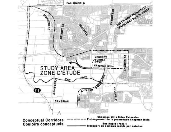
The City of Ottawa has initiated the Chapman Mills Drive Extension (Longfields Drive to Strandherd Drive) and Bus Rapid Transit (Greenbank Road to west of Cedarview Road) Environmental Assessment (EA) Study to determine the most appropriate means to accommodate and manage increasing transportation infrastructure requirements around the Barrhaven Town Centre area.

Study area - Chapman Mills Drive (Longfields Drive to Strandherd Drive) and Bus Rapid Transit (Greenbank Road to west of Cedarview Road).

chapman_mills_study.jpg


This first Open House will provide an overview of study progress to-date including:

The evaluation of alternative corridor alignments
An overview of design alternatives which will be considered in the next phase of the study


Back
Top