noirish Los Angeles


Status
Not open for further replies.
Oneonta Junction

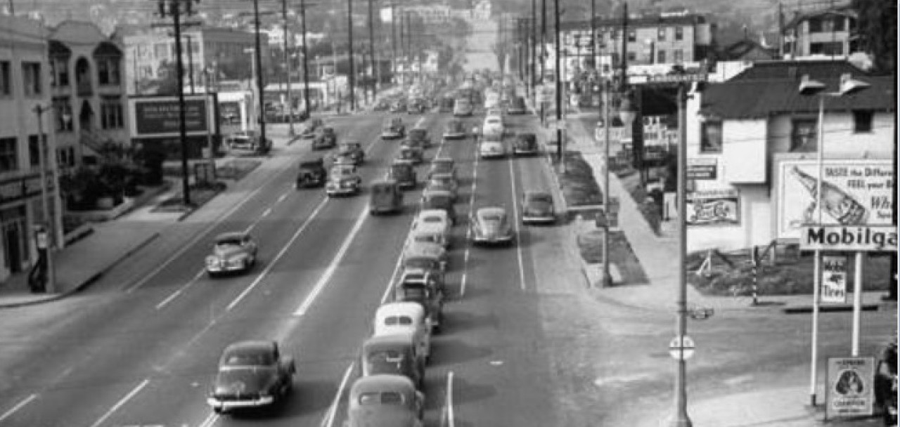
Oak Knoll runs mostly north and south through San Marino and Pasadena.

Its an upscale residential area. Most homes on the street are priced in the millions. The famous Huntington Hotel is located on this street. I've marked the path in green.

I used to drive my old '49 Chevy every day when I worked at the Academy Theater in Pasadena. Oak Knoll street has a lovely dream-like quality about it.


oak%20knoll_zpsh93s8czp.jpg

GMaps

Oneonta Junction dates from 1902 with the construction of Pacific Electric's Pasadena Short Line and Monrovia Line. They joined at Huntington Drive and Fair Oaks Avenue and the junction was named "Monrovia Junction. However, not long thereafter Mr. Huntington ordered the name changed to that of his home town, Oneonta, New York.

A stylish stucco depot was "built in the space formed by the wye and on the roof was a glassed in cabin housing an interlocking plant that controlled the crossing of the Monrovia line and the Southern Pacific's Pasadena branch. The interlocker was a 16 lever machine built by Union Switch and Signal Company."

Pages 7 and 8 shown here are from Lines of Pacific Electric, Interurbans Special No. 16 first published in April, 1953 by rail historian Ira L. Swett.


Cheers,
Jack
 
Last edited:
Oneonta Junction dates from 1902 with the construction of Pacific Electric's Pasadena Short Line and Monrovia Line. They joined at Huntington Drive and Fair Oaks Avenue and the junction was named "Monrovia Junction. However not long thereafter Mr. Huntington ordered the name changed to that of his home town, Oneonta, New York.

A stylish stucco depot was "built in the space formed by the wye and on the roof was a glassed in cabin housing an interlocking plant that controlled the crossing of the Monrovia line and the Southern Pacific's Pasadena branch. The interlocker was a 16 lever machine built by Union Switch and Signal Company."

Pages 7 and 8 shown here are from Lines of Pacific Electric, Interurbans Special No. 16 first published in April, 1953 by rail historian Ira L. Swett.


Cheers,
Jack

Wig Wag,

Great article there. I can recall when they were repaving the portion of Huntington from Fremont to just past Fair Oaks around 25 yrs ago, the contractors dug down deep enough that they pulled up all the old tracks and all the ballast and such. I was able to pick up a few very corroded spikes from the mountain of dirt that they had dug up. But, through the years since then they, were accidentally lost during one of my moves. Wish I still had them. :(

Casey
 
Los Angeles / unnamed street


BrerHair at http://www.jalopyjournal.com/

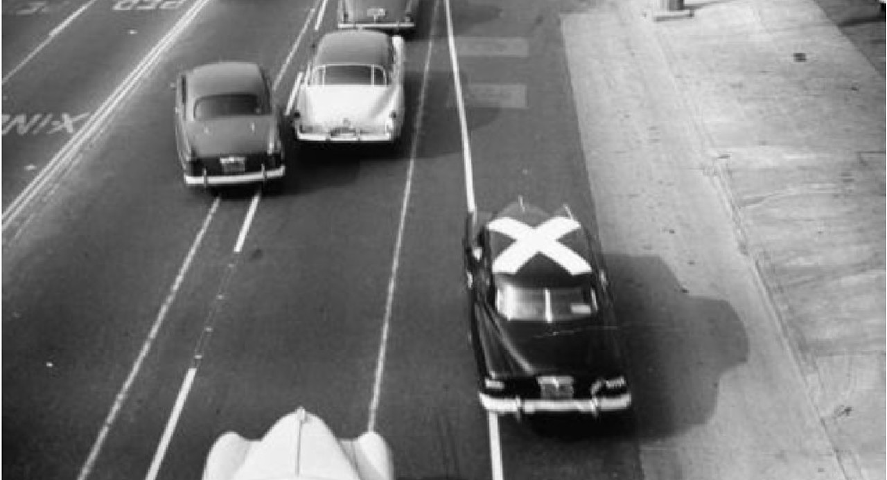
"What's up with the big white X?"
__
Looks like a mark for aerial photography- mapping, but very strange to put it on something movable- perhaps the car belongs to the survey outfit, and the mark is on top to prevent someone else from parking over the mark if it was on the pavements. Such temporary marks would have been carefully located by ground survey and thus would allow precise adjustment of the photomosaicss to convert to topo maps
 
Thanks for the information on Oak Knoll CBD.


The M. C. Wentz Co., 780 South Arroyo Parkway, Pasadena CA.


http://collection.pasadenadigitalhistory.com/cdm/singleitem/collection/p16237coll8/id/774

I was rooting for this clever little building built in 1945 (I would have guessed a good ten years later...around 1955).

...alas, it's been replaced by a Tuesday Morning store :( (with a fitness gym in the back)


GSV
__


I was going to end my post there, but I noticed, for some reason, the google-mobile drove through the parking lot and behind the building.
(maybe the driver was trying to see inside zumba class ;)--


from the parking lot the building's character takes on a more industrial look, especially the windows.


detail


This window in the back facing the alley could possibly date from 1945.


detail


AND....on the opposite side of the building (the side that shows in the vintage photograph) I noticed this two step progression along the roof.


detail


http://collection.pasadenadigitalhistory.com/cdm/singleitem/collection/p16237coll8/id/774

so....I'm pretty sure the 1945 building is still standing. Now wouldn't it have been totally cool if they had kept this design and worked with it.


p.s. -anyone know what the Wentz Company made?

__

For some unknown reason, the Googlemobile has taken to suddenly dumping you into a view of some random alley. Very disconcerting, especially if the alley is blocks or even miles away......
 
For some unknown reason, the Googlemobile has taken to suddenly dumping you into a view of some random alley. Very disconcerting, especially if the alley is blocks or even miles away......

The alley photos look correct tp me.

The M. C. Wentz Co., 780 South Arroyo Parkway, Pasadena CA.


http://collection.pasadenadigitalhistory.com/cdm/singleitem/collection/p16237coll8/id/774

so....I'm pretty sure the 1945 building is still standing. Now wouldn't it have been totally cool if they had kept this design and worked with it.

I also think that the original building still stands, but the rear third was added after the picture above was taken. The images for this location on Historic Aerials are a little blurry when you zoom in closely, but I'm pretty sure I can make out the original building on the 1948 image, with an extension visible by 1952. Of course, this might not be the extension we see today.

LAMCWentz3.jpg

Google Maps

p.s. -anyone know what the Wentz Company made?

An article on realorrepro.com has this information:

"One of the most popular of the old collectible patterns being reproduced is a multicolored design called Rodeo. Original Rodeo was made by Wallace China Company of Los Angeles, California for the M.C. Wentz Company of Pasadena, California. Wentz marketed the china in their full line of western-theme housewares called Westward Ho."

Here is a Wallace China Westward Ho Rodeo salad plate.

LAMCWentz1.jpg

eBay

M C Wentz's name doesn't appear on the plate above, but it can be seen on these Westward Ho Gauntlet oven mitts.

LAMCWentz2.jpg

www.worthpoint.com
 
For some unknown reason, the Googlemobile has taken to suddenly dumping you into a view of some random alley. Very disconcerting, especially if the alley is blocks or even miles away......

:previous: I don't understand what you're saying oldstuff.

Go to GSV yourself and take a look at the back of the building in question.

Here's the address again, 780 S. Arroyo Parkway, Pasadena. Take the google-mobile through the parking lot and turn left. You'll find the window I posted.


detail / gsv


You can see the route the google-mobile took through the parking lot in the aerial below.

google_earth


__
 
Last edited:
Here's the Hotel Tahoe at 1043 W 6th Street.

LAHotelTahoe1.jpg

eBay

I couldn't find any previous mentions on NLA, so I had a look at the City Directories. A couple of the earlier CDs list single residents at that address, but the first hotel I found was the Hotel Bray in 1929. The 1932 and 1936 CDs show the name had changed to the Palace Hotel/Hotel Palace, which is the incarnation that appears to the left of the Hotel St Paul in the detail below. The Hotel Tahoe name first appears in 1938, and continues through to 1969.

Many of the other buildings in the detail have been covered before on NLA.

LAHotelTahoe2.jpg

Detail of picture in USC Digital Library

Today, the whole block is a parking lot!

LAHotelTahoe3.jpg

Google Maps
 
:previous: I saved that Hotel Tahoe postcard as well HossC.
I didn't post it yet because I wasn't able to dig up any information.

...so good job my friend. :)
 
Last edited:
When I first saw the thumbnail of this postcard and read "Sky Air Motel", I initially thought of the Carl's-at-the-Beach Sea Air Motor Apartments which e_r posted pictures of in post #8534. The Sky Air Motel was actually at 2590 Glendale Boulevard. The seller dates the card as 1940s.

LASkyAirMotel1.jpg

LASkyAirMotel2.jpg

eBay

Here's the motel in 1948. Next door is the gas station on the far right of the postcard. The road to the right is Fletcher Drive, which leads under the wooden rail bridge to Currie's Ice Cream, as seen in post #3183 by LAboomer52.

LASkyAirMotel3.jpg

Historic Aerials

Looking at the later images, the motel buildings disappear between 1964 and 1972. Today, there's a small strip mall where the motel used to be, and a car wash where the gas station was.

LASkyAirMotel4.jpg

Google Maps
 
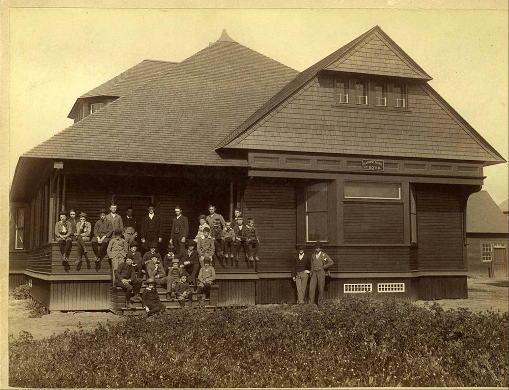
Classical School for Boys in Pasadena

"Classical School for Boys, drilling, c.1891"


http://collection.pasadenadigitalhistory.com/cdm/singleitem/collection/p16237coll8/id/167

The photographer was William H. Hill, and his practice was located in Pasadena.

The best clues to the location of this school is the large white barn in the background and the large mansion on the left, behind the tree. (as well as the house in the distance on the right).
__
Let's not leave out the girls . . . .

Classical%20Schools%20for%20Boys%20and%20Girls%20in%20History%20of%20Pasadena%201895_zpsnthjknsj.jpg~original

History of Pasadena (1895) by Hiram A. Reid @ HathiTrust -- http://babel.hathitrust.org/cgi/pt?id=loc.ark:/13960/t5n87w36g;view=1up;seq=216

P.S. Today, the building at 124 S. Euclid looks newer than 1892, and 59 S. Euclid looks to be under a mall. But maybe the numbering changed since then? I know little about Pasadena.
 
Last edited:
:previous: Thanks for finding this information Flyingwedge.
I thought "classical school for boys" was just a generic term describing the photograph.

So are there any images of 59 and 124 S. Euclid Avenue?
 
Last edited:
Last night I came across this amazing photograph of The Broadway Pasadena parking lot [no date]


http://pasadenadigitalhistory.com/

We're looking east toward Los Robles Avenue and the flamboyant Grace Nicholson Building.


Today a new building blocks this old view (see below).


google_earth


Today, the Grace Nicholson Building is the Asia Pacific Museum. (I believe we discussed this wonderful building in the early days of NLA)


To read about the history of the Grace Nicholson Building go here:
http://www.pacificasiamuseum.org/_about/building.aspx
__


below: Here is the massive building that replaced The Broadway Pasadena.


GSV

I'm not sure when the old Broadway Pasadena building was torn down.

hmmmm...or was the older building incorporated into this building somehow? I doubt it, but it's a slim possibility.
I only say this because the aerial I posted almost looks like there's a building within the newer building.
 
Last edited:
So are there any images of 59 and 124 S. Euclid Avenue?

"Classical School for Boys, 59 So Euclid Ave opened in 1889. New building erected in 1891. Steven Cutter Clark, principal."

LAClassicalSchoolBoys.jpg~original

Pasadena Digital History Collaboration

"Orton Classical School for Girls, 1892"

LAClassicalSchoolGirls.jpg~original

Pasadena Digital History Collaboration

From the Wikipedia page about the Classical School for Girls:

"The first building at the school, which housed a single classroom, was constructed in 1892. A gymnasium was built at a later point, and a dormitory was constructed in 1900. A bungalow which served as Miss Orton's home was built in 1908. The buildings were designed by Frederick Roehrig in the Victorian Colonial Revival style; they were probably the only educational buildings designed by Roehrig, a significant Southern California architect. The classroom and gymnasium burned down between 1910 and 1925 and were replaced by a social hall. The dormitory is now the only building remaining at its original location; while the bungalow is also still at the site of the school, it was moved to a new foundation in 1947. The dormitory was added to the National Register of Historic Places on August 4, 1995."

Here's the dorm building at 154 S Euclid Avenue.

LAClassicalSchoolDorm.jpg~original

GSV
 
Last night I came across this amazing photograph of The Broadway Pasadena parking lot [no date]


http://pasadenadigitalhistory.com/

We're looking east toward Los Robles Avenue and the flamboyant Grace Nicholson Building.


Today a new building blocks this old view (see below).


google_earth


Today, the Grace Nicholson Building is the Asia Pacific Museum. (I believe we discussed this wonderful building in the early days of NLA)


To read about the history of the Grace Nicholson Building go here:
http://www.pacificasiamuseum.org/_about/building.aspx
__


below: Here is the massive building that replaced The Broadway Pasadena.


GSV

I'm not sure when the old Broadway Pasadena building was torn down.

hmmmm...or was the older building incorporated into this building somehow? I doubt it, but it's a slim possibility.
I only say this because the aerial I posted almost looks like there's a building within the newer building.

ER,

The Broadway was torn down sometime in the 80's. The current building was being built while I was living at the old YMCA a few blks away near City Hall. I moved out of there in late '03, and they were just finishing the construction about that time.

Hope that helps,

Casey
 
Pasadena YMCA

:previous: Yep, that helps a lot Casey. Thanks for the clarification. I appreciate it.

Is the old YMCA where you lived still standing?

__

Yes, it is. It is now called Centennial Place and we have discussed it here in the last 6 months or so. Located at 235 E. Holly St.
 
Status
Not open for further replies.


Back
Top