noirish Los Angeles


Status
Not open for further replies.
I'm awfully impressed with all the information you NLA'ers were able to glean from the two sepia stereoviews I posted yesterday.
__

...so why stop there? :)


"An early view of the San Fernando Valley"


http://www.businessinsider.com/los-angeles-vintage-pictures-2014-4

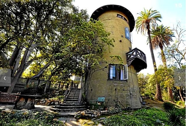
Once again, there is a building with a turret/tower. -note the natural slope to it's right (our left)

I thought one of you aces might be able figure out the location by aligning the mountains. (I tried..without much success)
__

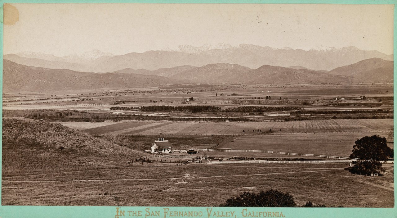
It looks like it was taken from around or on "Bee Rock" in what would now be Griffith Park, looking toward Glendale. The river is in the foreground, the roads in the back at the foot of the Verdugo Hills would be about where the 134 freeway is now. Mount Wilson would be in the range below the snow covered peaks toward the center of the photo.
 
It looks like it was taken from around or on "Bee Rock" in what would now be Griffith Park, looking toward Glendale. The river is in the foreground, the roads in the back at the foot of the Verdugo Hills would be about where the 134 freeway is now. Mount Wilson would be in the range below the snow covered peaks toward the center of the photo.
Thank you oldstuff. Here's an article from a couple of years ago that shows Bee Rock these days and its views http://californiathroughmylens.com/bee-rock-hike-griffith-park
 
Thank you oldstuff. Here's an article from a couple of years ago that shows Bee Rock these days and its views http://californiathroughmylens.com/bee-rock-hike-griffith-park

Just now found a picture of the building with the cupola, from a lower and different angle. It was part of the Rancho Los Feliz Ostrich Farm which was run by a Charles Sketchley, in partnership with Griffith J. Griffith, from 1885-1889. (KCET has info on their website and the picture) There was an "Ostrich Farm Railway", a narrow guage railway, running from downtown to the ostrich farm, which eventually became part of Pacific Electric.
 
Last edited:
:previous:

I assume that this is the KCET article you're talking about:

How L.A. Got One of the Country's Largest Urban Parks

Their caption for the picture below is "The Rancho Los Feliz ostrich farm, circa 1885." The original picture is from LAPL where it's dated at circa 1880s and has the caption "Panoramic view of Ostrich Farm Park in Glendale, located near Burbank on the old railroad from Burbank Junction, later Sanborn Junction and Sunset Blvd. ".

LARanchoLosFeliz.jpg

LAPL
 
I posted this picture of the Occidental College a few weeks ago along with a couple of others in post #25858, with some more in post #25868.

The Occidental College has been mentioned a few times on NLA, but I don't think we've seen a picture of the Highland Park buildings before. The postmark on this card dates it at 1907.

LAOccidentalCollege1.jpg

eBay

This postcard of the Charles M Stimson Library appears to be from the same series.

LAOccidentalCollege6.jpg

eBay
 
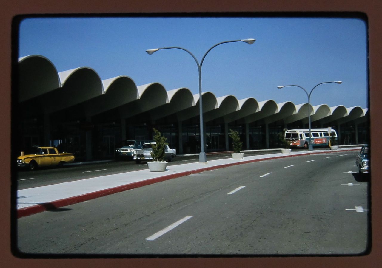
This 1964 slide surprised me a bit.

"1964 Original Slide Los Angeles AIRPORT LAX TERMINAL Modernist Architecture"


http://www.ebay.com/itm/1964-Origin...469?pt=LH_DefaultDomain_0&hash=item339dfdce75

I don't recall this 'scalloped' roof. Which terminal was this?
__

Can't be LAX. I'm looking at the curved roadway. This curve would have to be somewhere between terminals 3 and 4. Before the early 1980s when the Tom Bradley International terminal was built, there was nothing but a flat wall between 3 and 4.
 
before and after

I came across this great looking slide earlier this week on eBay.


eBay


....and here is the same view in 2014 (413 7th Street)

GSV

I found the Lyndon by using the Hotel Cecil as a guide post. (I thought the blade sign said London in the vintage slide, so that caused some confusion)
__


I actually posted about the Lyndon back on May of 2013.
http://forum.skyscraperpage.com/showpost.php?p=6143310&postcount=14856

At one point the Lyndon was stripped down to it's shell. -see it here:
http://forum.skyscraperpage.com/showpost.php?p=6143331&postcount=14857

__
 
Last edited:
:previous:

I assume that this is the KCET article you're talking about:

How L.A. Got One of the Country's Largest Urban Parks

Their caption for the picture below is "The Rancho Los Feliz ostrich farm, circa 1885." The original picture is from LAPL where it's dated at circa 1880s and has the caption "Panoramic view of Ostrich Farm Park in Glendale, located near Burbank on the old railroad from Burbank Junction, later Sanborn Junction and Sunset Blvd. ".

LARanchoLosFeliz.jpg

LAPL

That's the one. Thanks for posting it ( I can't post) This view is looking north toward Burbank
 
I came across this great looking slide earlier this week on eBay.


eBay

I found the Lyndon by using the Hotel Cecil as a guide post. (I thought the blade sign said London in the vintage slide, so that caused some confusion)

__

15973093554_ce7f4a9c3f_o.jpg


The Lyndon! By none other than the esteemed Robert Brown Young.
 
:previous: my bad. -thanks for the correction Beaudry (and Handsome_Stranger for pointing it out)

__


The Edison Building in the 1970s when it still said EDISON at the top.


Today it says Torrey Pines Bank on the top.:( (Torrey Pines sounds like a golf course)


https://www.flickr.com/photos/26021073@N03/8543163771/in/photostream/lightbox/

Couldn't the EDISON sign have been included in the historical landmark? Haven't other signs been protected in this manner?

__
 
Last edited:
15973093554_ce7f4a9c3f_o.jpg


The Lyndon! By none other than the esteemed Robert Brown Young.

This is a great photograph Beaudry. R.B.Y.'s design is very clean and sophisticated.


Do you have information on the building next to the Lyndon in my vintage slide?
I noticed there's some writing at it's roofline...but it's illegible. (I've put a square red box around it)


eBay
 
Last edited:
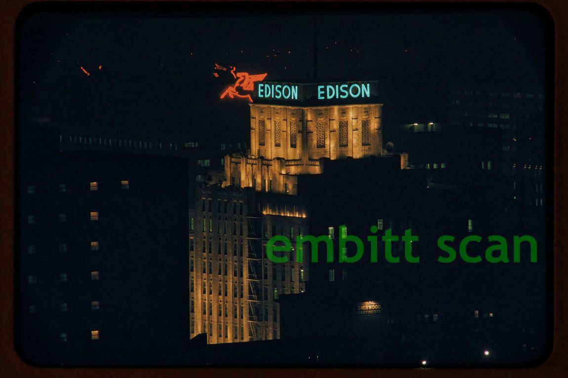
Lighting scheme on the Edison Building. (1950s?)


http://www.ebay.com/itm/Original-Sl...045?pt=LH_DefaultDomain_0&hash=item51cc207c6d

Also visible is the red Pegasus on the General Petroleum Building (built 1949) over at 612 S. Flower.
if you looks closely you can also see the back of the other Pegasus' facing in the opposite direction.

-hey, I just noticed the dimly lit Sherwood Apartments sign.
(under the i in Embitt)
__

One would like to think the sign could have been landmarked along with the building, yes...I'm sure the owners would argue that would impact their ability to get a tenant. Heck, the Bekins sign in Pasadena was National Register and the new tenant fought to change it and won.

This slide would have had to've been shot from the 1948 Pacific Telephone & Telegraph building at 434 S Grand—if this slide is really late-50s it's before Woodford & Bernard's 1961 Pacific Telephone switching center at 420 S Grand (which we know as the building with the microwave tower atop).

Am I being all nitpicky? I do know I'm bidding large on this sucker!
 
This is a great photograph Beaudry. R.B.Y.'s design is very clean and sophisticated.


Do you have information on the building next to the Lyndon in my vintage slide?
I noticed there's some writing at it's roofline...but it's illegible. (I've put a square red box around it)


eBay

According to the Baist map, 407 was the "Kenyon Hotel." Guess that's what's up on the roofline. City Assesor dates what's now 407-11 E 7th as having been built in 1979, so one assumes that's till when the Kenyon lasted.
 
There was another link at the page you referenced on the watertower:
Fullscreen%2Bcapture%2B2192015%2B73521%2BPM.jpg

http://www.sgvtribune.com/lifestyle...ouse-in-pasadena-presents-decorating-problems

Curbed Los Angeles has six pix of the interior before it was last sold:
Fullscreen%2Bcapture%2B2192015%2B80444%2BPM.jpg

MLS


LOL, now I'm just more confused than ever!

I knew I had seen pictures somewhere before. Never seen that particular photo of the exterior though, thanks!

About the confusion of the 11th & Bonnie Brae homes, it's quite mutual. Lol. I wish I could remember where I read that 1851 had been moved. Couldn't find it, but as consolation, I did find a few 80's-eraish-looking photos of 1851 and 1047 that I don't think ever been posted here, the latter of which has definitely seen worse days than we even realized (still with that horrible replacement porch railing).

11th%20Street-1851%20W.%20designed%20by%20R.B.%20Young%20moved%20from%201000%20block%20of%20Olive%20to%20present%20location%20in%201909%20photo%20circa%201980s_zpstv3e0xoy.jpg

Bonnie%20Brae%20Avenue-1047%20S.%20Alphonse%20J.%20Forget%20House%20circa%201980s_zpsnjuggo0b.jpg
LA City Planning
 
I don't recall seeing this fascinating image on NLA.

"This is the Southern Pacific railroad as it enters Santa Monica. The railroad ignited a bustling tourism along the Pacific Coast." -Business Insider


http://www.businessinsider.com/thelife

So what do you think all that lumber is for? -the future Santa Monica depot? (this is just a guess)
__
 
Last edited:
I searched and couldn't locate this image on NLA.

"View of the Founders Building of the University of Southern California College of Medicine located on Buena Vista street (later N. Broadway), 1890."


http://cdm16003.contentdm.oclc.org/cdm/singleitem/collection/p15150coll2/id/3581/rec/76


-you can clearly see the USC emblem in this detail.

http://cdm16003.contentdm.oclc.org/cdm/singleitem/collection/p15150coll2/id/3581/rec/76


below: While looking for a street number I noticed these stylized 'Corinthian' columns that line the front porch. -very unusual, a nice touch.


detail

...but no street number.

So where on Buena Vista was this located?
__
 
Last edited:
Fullscreen%252520capture%2525209132011%25252094407%252520PM.bmp.jpg


2203 S Harvard-- Hattie McDaniel was instrumental in helping get restrictive housing covenants banned by the Supreme
Court in 1948. Here's an older post about her house: http://forum.skyscraperpage.com/showpost.php?p=4828583&postcount=1194

And another: http://forum.skyscraperpage.com/showpost.php?p=5203826&postcount=3283


McDaniel (center), in front of her house on South Harvard Boulevard in L.A.’s West Adams, with World War II volunteers in 1942. McDaniel was instrumental in a 1948 U.S. Supreme Court decision striking down restrictions against African-Americans moving into the area, which is southwest of downtown.http://www.hollywoodreporter.com/news/oscars-first-black-winner-accepted-774335


hm-hattie-uso.jpg
http://thehistorychicks.com/wp-content/uploads/2014/10/hm-hattie-uso.jpg

More on McDaniel: http://www.hollywoodreporter.com/news/oscars-first-black-winner-accepted-774335
 
Status
Not open for further replies.


Back
Top