noirish Los Angeles v2.0


eBay ............................................................................................................................................................ARCADIA, CA.


115 East Huntington Drive in Arcadia


tIJOL1k.jpeg

loc.gov - White Pages - Northeastern Monrovia 1986


The tanned secretaries are gone but martial arts are still happening next door.


0pbcsJT.jpeg

Google Street View
 
Thanks Scotty B....If you don't mind me asking, what instrument do you play?


Added later:

The bulbous criuciform shape of the. .um. .'doo-hickeys' are inside as well.


I also read that the mesh tent-like ceiling has twinkling lights like stars above it. (love it)


I want to go there and see a concert. :)

.

I play drums and percussion, thank for asking. I've been on staff as the percussion coach for almost 40 years (yikes!) at Caltech, so I've done my time in Beckman. The CIT orchestras and chamber groups no longer perform there, the acoustics are suitable for lectures but not much more. There is a notable lack of an actual theater on campus, which is a shame.
And as I think about it, I'm not sure those hanging balls don't light up. I'll report back when the auditorium is back in use.
 
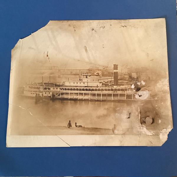
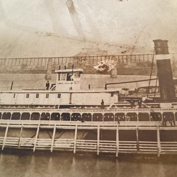
This one is going far afield so my apologies upfront. But I think it may be both a Louisville Slugger and March Madness Slamdunk rolled into one. Popped down to the flea market yesterday to see what might surface. A dealer I have known for many years had this sitting out and said his wife had been telling him to throw it away but he kept hanging on to it suspecting it was something good. I suggested he might ask some of the noirishers here since they’re so skilled at solving puzzles. Instead he just gave me the photo and I said I’d go to work on it. I suspected an early railroad bridge on the upoer Missouri or Mississippi valleys. A couple of possibles came up including the Ohio River, but nothing definite due to the limited view here. But I also thought the sternwheeler had the name EMMA something. Lo and behold, it seems to be the fourth version of the EMMA GRAHAM built in the mid-1870’s and sunk around 1886. And the bridge looks like the eastern side of the 14th Street/Pennsylvania Railroad/Panhandle link from Louisville KY over to Jeffersonville Indiana. So I think this looks southward down the river not far from where a big shipyard was that constructed many other paddleboats. Can anyone assist on solving this?

IMG-4460.jpg
 
.

Here's a very short home movie (1980) of tourist's view from their room in the old Hollywood Holiday Inn.


LINK to the video at the bottom of the post.

. . or Click here if you prefer - - - >..https://www.shutterstock.com/video/clip-4019820129-los-angeles---1980-home-movie-footage


There are good view of the Highland Methodist Church and Yamashiro's. (from basically eye level since they're on an upper floor)


BUT at .55 seconds the tourists appear to have changed hotels.

Here are two views from the new vantage point.


.55 secs.


.59 secs.


Can anyone figure out where the tourists moved to....:shrug: . . . by using these last two views?...I haven't been able to figure it out.


Link to home movie

.
 
Last edited:
1029 W Gardena Blvd.

Felix's Bike Shop is the current business at 1029 W Gardena Blvd and has been for 20 years or more. It is an interesting and overstuffed bike shop, especially if you are into older bikes, Schwinns in particular.
The location has been a bicycle shop for many years, likely going back to the '50s or '60s. I have searched for anything that would show evidence of previous ownership or name but come up empty. I am appealing to anyone here to see if and old advertisement or something similar can be unearthed. I would love to find any information related to the location.

vl3OAHH.png

GSV

gWJ1d1N.png

https://www.yelp.com/biz/felixs-bicycle-shop-gardena?osq=Bikes
 
.

Hmmm. . . how odd.

Never heard of a Hula Club Hofbrau. :shrug:

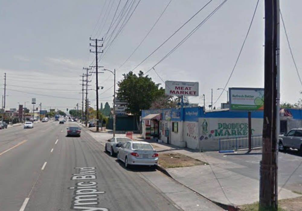
East Los Angeles - Feb. 7, 1980 .. (Olympic Blvd?)


John Humble

Dare I say. . .German hula girls? ...:)


Let's take a closer look at that cross-street sign.


It's a bit blurry.


.
 
Last edited:
.

Here's a very short home movie (1980) of tourist's view from their room in the old Hollywood Holiday Inn.


LINK to the video at the bottom of the post.

. . or Click here if you prefer - - - >..https://www.shutterstock.com/video/clip-4019820129-los-angeles---1980-home-movie-footage


There are good view of the Highland Methodist Church and Yamashiro's. (from basically eye level since they're on an upper floor)


BUT at .55 seconds the tourists appear to have changed hotels.

Here are two views from the new vantage point.

.55 secs.


.59 secs.


Can anyone figure out where the tourists moved to....:shrug: . . . by using these last two views?...I haven't been able to figure it out.

Link to home movie

I think the tourists just moved to the other end of the hotel. The Madison is at 1746 N Orange Drive and the buildings in the last image are on Hollywood Boulevard.
 
.
LOL ....All that work for nuttin'.

I really thought they moved to a different hotel. ... I'm starting to see mysteries where there aren't any.

.
 
.

Hmmm. . . how odd.

Never heard of a Hula Club Hofbrau. :shrug:

East Los Angeles - Feb. 7, 1980 .. (Olympic Blvd?)


John Humble

Dare I say. . .German hula girls? ...:)

Let's take a closer look at that cross-street sign.


It's a bit blurry.

I don't know anything about the club, but I think we're looking east on East Olympic Boulevard. The circled sign says La Puerta Street. It looks like the building and sign frames survive.

5a0c0868-8ad9-46ce-90d4-4ceb01a61ac7.jpg

GSV


Image via Flickr...

"Photograph taken circa 1918.

The following is written on the back:

"Premcell Home in Los Angeles, California"


I ran a couple of CD's around that year for "Premcell", no luck....I then researched the surname, and found that it just does not exist....I guess it's possible "Premcell" refers to a type of home, but I can't find any reference along those lines.

My assumption is that the handwriting on the back of the photo is in script/cursive, and the poster has misinterpreted the name. 

It appears we have a 4 digit house number....


.
:previous:

Intresting post, riichkay. I'll see if I can dig something up.


Gasp!

I had forgotten that the 5th Ave. Theater in Inglewood was ever painted like this!


eBay


The address is 231 W. Manchester Blvd., Inglewood. (5th Ave. is the cross-street)


Today it's a CHURCH.


GSV
.
 
Hi all you Los Angeleno historians and film noirist super geniuses,

I am trying to nail down the background beach location where Walter Neff (Fred MacMurray) is driving around Phyllis Diedrichson (Barbara Stanwyk)'s daughter Lola (Jean Hetherington) on a Sunday after he and Phyllis have killed Phyllis' husband in Billy Wilder's glorious LA-based noir DOUBLE INDEMNITY (1944). It's definitely a So Cal beach location and the internet seems to suggest it might be Malibu colony though there is also supposition that it could be Venice (Sunset Pier) or Santa Monica or even PV. The big clue I see is a distinctive metal archway / gate / sign which passes by Walter's car as they drive along the beach. I slowed down the footage in the attached link from the film here; at 52 seconds you get your best look at the arch.

This is a composite of the image of the metal beach archway I put together from various clips of the sequence above. https://imgur.com/a/KHuXtxI

It's reminiscent of the Redondo Beach archway but that sport fishing arch / sign was too far from the ocean and didn't go up until the late 1960s and DOUBLE INDEMNITY was shot in late 1943. AI suggested it could be an arch at Venice (Sunset Pier) which works out timing-wise though there aren't any good pics of it that I can find for comparison. It could also be the SM Pier (a similar arch to today and the neon was turned off during the war) but it still doesn't seem quite right.

This Santa Monica beach archway from 1898 is the closest image I've found.
pierave-1898.jpg

The shot is from this website:https://oceanpark.wordpress.com/top/ocean-park-history/

Apologies for my clunky formatting, I'm new at all this! Thoughts / ideas on the answer?
 
Yes, just a bit far afield, so my apologies too

This one is going far afield so my apologies upfront. But I think it may be both a Louisville Slugger and March Madness Slamdunk rolled into one. Popped down to the flea market yesterday to see what might surface. A dealer I have known for many years had this sitting out and said his wife had been telling him to throw it away but he kept hanging on to it suspecting it was something good. I suggested he might ask some of the noirishers here since they’re so skilled at solving puzzles. Instead he just gave me the photo and I said I’d go to work on it. I suspected an early railroad bridge on the upoer Missouri or Mississippi valleys. A couple of possibles came up including the Ohio River, but nothing definite due to the limited view here. But I also thought the sternwheeler had the name EMMA something. Lo and behold, it seems to be the fourth version of the EMMA GRAHAM built in the mid-1870’s and sunk around 1886. And the bridge looks like the eastern side of the 14th Street/Pennsylvania Railroad/Panhandle link from Louisville KY over to Jeffersonville Indiana. So I think this looks southward down the river not far from where a big shipyard was that constructed many other paddleboats. Can anyone assist on solving this?

IMG-4460.jpg

Wow sharp eye to ID the boat and especially the bridge, which I never would have guessed! Interestingly
(or not), LAPD Chief John M. Glass (1889-99), and the LAPD's first black officer, Robert W. Stewart (1889-1900),
had both been Jeffersonvillians before each moved west in 1886.

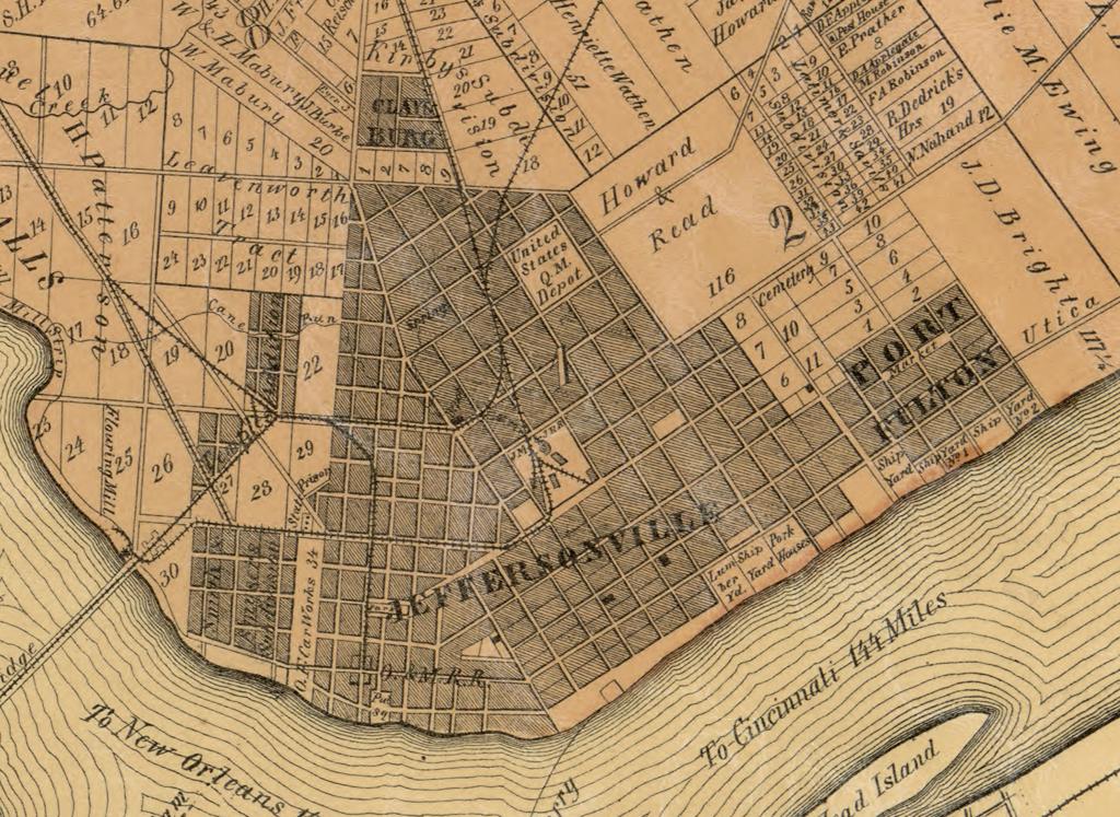
From what I know, Jeffersonville was home to the Barmore shipyard until 1885. Just upriver was the larger
Howard shipyard (there is a steamboat museum in the old Howard family mansion). And there were shipyards
next door in Port Fulton. The shipyards are shown (if not named) on this 1868 map and on this 1875 map.

In the photo, is the boat at one of the shipyards (for a repair?) or downriver at the Jeffersonville ferry landing?

According to the University of Wisconsin, that particular Emma Graham was built in Cincinnati.
 
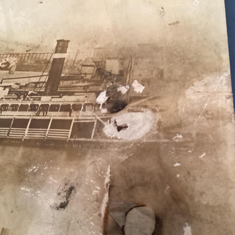
Flyingwedge: Unfortunately front of boat area suffered photo damage, but we cannstill see a group of buildings just beyond at the shoreline. I would expect to get this angle with the bridge parts the camera must have been somewhere down near the tip on those two maps so this could be west (river south) of the boatyards and nearer the public landing or the railroad warehouse/station area? Here’s the section of that photo:

IMG-4464.jpg
 
FW’s linked 1875 map (via LOC) detail enlarged:

IMG-4470.jpg


Bridge is to left with Ohio Falls beyond that area. Oddly, this is 144 miles beyond the route that this boat was supposedly on (Pittsburg-Cincinnatti packet service) but things do change.
 
Last edited:
.

I don't believe we have seen this amazing c.1880 photograph on NLA.


"A portrait of men standing outside the Woodhead and Gay Store on 46 and 48 North Spring Street, Los Angeles, ca. 1880. Four men stand posed in front of the Woodhead & Gay General Store next to a horse-drawn cart to the right of them in back of which a fifth man stands, while several others in the background move along or seem uninterested in the photograph. A plow and other, boxed goods are piled in front of one of the men to the left. The general store itself is one story tall features three large panes for display windows, and extends eaves over the group of men. The H.J. Woollacott liquor store is also visible to the right."

losangelesrelics


The Woodhead & Gay store in the 83/84 city directory.


.


Back
Top