• City-versus-city activity is flat-out banned from being posted here in all its forms.

    City vs city trolling sets up a rather nasty and personal fight between forumers from one place and forumers from another place, potentially affecting hundreds of members any time it breaks out. Nothing good comes of versus-trolling, but long after the insults and mockery have been removed, bad feelings between individuals and between groups tend to linger, oftentimes popping up in unrelated threads for months afterwards.

    Thus, when it comes to 'versus' trolling, a line must be drawn--sharply. Anyone who crosses that line shall be disciplined, up to and including suspension and even summary banishment without warning. Forum moderation and administration shall be the arbiter of what constitutes versus-trolling, so if you think your post might be perceived as an unfair attack on an entire city that will upset residents there, tread lightly or reconsider how you intend to express your opinion. No forumer shall successfully claim ignorance of our policy against versus trolling, and no forumer should believe he can get away with it.

    The ban on versus activity applies to all posts and all threads, even ones that are not initially set up as city-versus-city.

    If you see any troublesome posts please report them using the "report a post" icon -
    report.gif
    in the upper right corner of every post on the forum.

Cities with most impressive transport networks?


kittyhawk28

New member
Which cities have the best highway or railway transportation networks? More interestingly, which cities manage to do both very well? It seems for the US, cities tend to do very well in either car infrastructure or public transit, but typically not both. For example:

Best freeway network: Los Angeles - probably the most extensive, sprawling network of wide freeways in the country, making up for its pretty weak (albeit growing) metro and commuter railway networks. Even despite the traffic, driving across the LA metro is still generally fast, and all the freeways are very wide, extensive interchanges, and decently maintained.
Screenshot-2025-11-15-001927.png

Best railway network: New York - unquestionably the best, most extensive, rapid transit network in the country, and arguably North America, as well as the best commuter railways in the country. Its subway runs 24 hours, and runs extremely frequently at <5 minute headways. However, driving in NYC proper is a nightmare, and its regional freeways (or "expressways") are overall pretty woefully maintained, outdated interchanges, and are pretty narrow/substandard by modern standards.
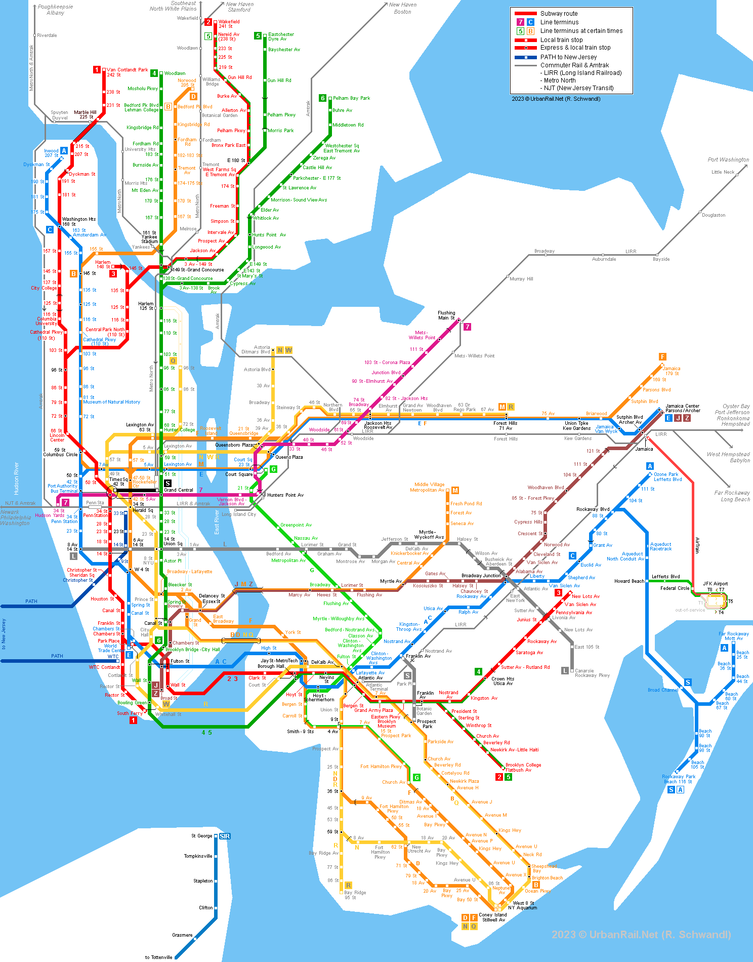
new-york-map.png


This trend holds true for other cities like Boston, Bay Area, Philadelphia, DC, or Seattle with pretty decent public transit systems, but poor/underdeveloped highway networks. The reverse also holds true for places like DFW, Houston, and Phoenix, which have very good freeway systems but horrible public transit, even for the US.

Places like Chicago seem to have balance their freeway network and public transit systems, but does not seem to have the best in either category. While a city like Atlanta seems to have an equally awful freeway network and public transit system, which explains why the city has so much traffic for its size.

Curious how this trend extends to other countries. If I understand correctly, Toronto is anomalous in Canada for having a very developed freeway system compared to other cities like Montreal or Vancouver, but until recently had weaker public transit than both.
 
London for public transport is of course the behemoth for the UK -some lines are the world's most frequent, 1 per minute, while my local mainline train station could be classed as the world's busiest by movement -a train leaving every 30 secs.

The city proper has 420 stations for Underground, Overground and light rail networks, another 340 stations for mainline trains.


sss.png

http://www.inat.fr/files/london-metro-subway-tube-map.png

For the metro area it would climb well over a thousand (1300 I think).

ss2.jpg


Additionally there are 40 tram/ streetcar stations and 24 ports for the ferry services:

riverbuses-full.png


Daily ridership for the tube + Elizabeth Line is over 4 million, Overground and light rail 1 million, mainline trains 3 million, buses 5 million

For buses there are 675 routes served by 8,700 buses, over 18,000 stops and 50 bus stations:


s.jpg

https://www.quickmap.com/bits/london-bus-map
 
Last edited:
In contrast the city has declared war on cars, digging up lanes on every major throroughfare (many 5 lane stroads are now 2 lane) to convert to bus and bike, and increasing the pavement area on almost every street.

hq720.jpg


Having learned the induced demand rule (one more lane), it's also banning daytime traffic in 113 LTN's (Low traffic neighbourhoods) and 500 school streets:

• Video Link


The result now is that London has the slowest traffic in the world - for every 10km/ 6 miles, expect to wait near 40 mins, something city hall wears with pride.
Bike journeys are up to 1.3m a day and they now outnumber cars in the financial centre.

The Cycle Network for bike-only lanes covers the whole city

greenground-cycling-map-of-london-new.png


With 12 bike 'Superhighways' for long distance riders:


The-map-highlights-the-location-of-various-London-Cycle-Superhighways-and-an-image-of-its.png


The Congestion Charge costs $20 to drive into the centre. Additionally the ULEZ (Ultra Low Emission Zone) covers the whole city and charges $16.50 for cars and $116 for larger vehicles that don't meet the standards. The metro, has a wider Low Emission Zone beyond that ($116 - $350):

londres-2_1024x576.png


This was highly controversial as it made the entire city convert to low emission vehicles or electric (which are exempt from both charges) - a win for the mayor Sadiq Khan who spent 5 years increasing the coverage, while losing votes. This was made after it was medically proven at a 2020 inquest that a young girl died from pollution (they attribute about 4,000 premature deaths a year in the city). Hers was the first proven death in the world, and now opens the floodgates for legislation:

h21.webp

www.bigissue.com

Ella was part of a generation that saw asthma climb to 10% of kids in the city. She spent her life 'struggling to breathe', in and out of emergency wards 25 times, while living on one of the city's busiest roads, the South Circular. Clean air is now a human right thanks to the 7 year legal battle by her mother.

In other news, London's main shopping strip -and busiest - Oxford St is the world's most polluted (if you consider NO2), multiple times the EU safety limit, and that reached its annual cap after 5 days into the new year. 570,000 people use it daily. Consider it one of the world's most dangerous streets, despite it being invisible. The mayor has spent 11 years trying to pedestrianise it, in a battle with the right wing council, Westminster. New legislation he's drafted has now meant the go ahead, which hopefully will see this:

http%3A%2F%2Fcom.ft.imagepublish.upp-prod-eu.s3.amazonaws.com%2F59420556-3f82-11e6-8716-a4a71e8140b0
 
Last edited:
UK's best car infrastructure is in the New Town of Milton Keynes, built in the postwar era, and nationally derided. It notably has a series of malls for a centre, though they're posthumously inserting a street with real shops and everything, possibly even people:

hhh.jpg

https://www.milton-keynes.gov.uk


The loose grid compartmentalises neighbourhoods into a patchwork of SFHs

Milton_Keynes_Redway.gif


49845693776_76be04c776_b.jpg


It's (in)famously seperated cars and pedestrians:

• Video Link
 
Last edited:
Tokyo reigns supreme in this catagory.

I mean... where to even begin. :haha:

When one thinks the transit situation is okay in ones region, one becomes humble real quick seeing the following below.

ede310f9ca20e0fa08c151634ca07671bfe8a490.jpeg


Nuts!

640px-Greater_Tokyo_rail_network.png
 
Los Angeles County has a pretty extensive bus system, LA Metro being the major transit agency in the County, but there are other transit agencies that border and overlap with Metro's bus routes as well as with each other's neighboring transit agencies' bus routes, of course. This map does not include the northern part of Los Angeles County; I believe Antelope Valley Transit covers that part of the county. I believe they even have an express bus that goes to downtown Los Angeles.

54924552452_f33f876d8d_k.jpg

54924552667_64afc7fcef_k.jpg
 
Shanghai or Beijing easily have the best subway systems but they are very dull to ride. The stations and lines were all built around the same time and are very sparsely decorated. This goes for basically any subway system in China. I much prefer systems that were built out over time where you can see all the progress in technology and architecture, like Tokyo or New York. Of course, that may just be the train nerd in me talking.
 
Shanghai's subway is right up there with Tokyo's. Probably even surpasses it. I've travelled many times on both.

800px-Shanghai_Metro_Network_en.png


500px-Shanghai_Metro_evolution.gif


^it has since expanded

1400px-Shanghai_Metro_Linemap.svg.png
 
Yeah Tokyo isn't really impressive just in terms of its subway since even with the two systems combined it's smaller than the systems of several Asian megacities and even NY, London and Moscow. It really shines when comparing overall rail networks which no one has yet to surpass.
 
The gif posted by Molson of Shanghai's subway expansion since 1996 puts into perspective the pathetic attempts at transit expansion in a city like Toronto, which takes decades to build a few kms of subway while other cities builds dozens of kms of subway during the same period.:hell:
 
Montreal probably most impressive freeway network in North America. Laval by itself has six different freeways.
 
The gif posted by Molson of Shanghai's subway expansion since 1996 puts into perspective the pathetic attempts at transit expansion in a city like Toronto, which takes decades to build a few kms of subway while other cities builds dozens of kms of subway during the same period.:hell:

dozens of lines of subway, in fact, when we are talking about the great cities of Asia. China's subway systems are absolutely first-rate, better even than those in Japan.
 
Yeah Tokyo isn't really impressive just in terms of its subway since even with the two systems combined it's smaller than the systems of several Asian megacities and even NY, London and Moscow. It really shines when comparing overall rail networks which no one has yet to surpass.

This is the key thing to understand about Japanese transit. :tup:

The JR's rolling stock is entirely electrified and on many central lines operates at levels surpassing subway/heavy rail in other countries. All of Tokyo's central JR railway lines have 2 minutes-or-under headway during commute times and 5 minutes-or-under during off times.

The Yamanote Line alone sees more daily ridership than NYC's entire combined MTA subway system (4.2 vs. 3.6 million average weekday riders). The MTA has 472 stations, the Yamanote Line has 30.

Yokohama Station is the 5th busiest in the world, but it only has 2 subway lines passing through with 155,000 weekday riders. The 9 above ground railways account for 800,000 weekday riders.

Now, take that Tokyo transit map, put it next to the Nagoya map, the Kyoto map, the Osaka map . . . they're all seamlessly integrated. I can get on the subway at the Mita Line station 3 minutes from my house and get off at any random station you pick in a faceless Osaka suburb. Or rural Okayama coastal village. And I'll have a bunch of ways to get there, from Shinkansen to entirely local lines the whole way. I can use the same contactless payment phone app, or my JR Suica IC card, on any public or private line in the country.
 
I think the most impressive is Chengdu, building 670km / 412 miles in 15 years (27 miles each year).

This is the equivalent to planning, building and opening London's tunnelled sections of the Elizabeth Line each year (read: the main part that actually goes through the city, not the suburbs that was overland and mostly already built). The Elizabeth line took 14 years to build and 7 years to plan.


by comparison in the same 15 year timeframe:

Shanghai built 400km / 250 miles = 16.7miles per year

Beijing 505km / 314 miles = 21 miles per year


Other timescales

Zhengzhou built 450km / 280 miles in 12 years = 23 miles per year

Hangzhou 516km / 321 miles in 13 years = 25 miles per year


All of these new additions are to networks bigger than London or NYC.

Many studies have been found on how they're able to build so quickly, and the main takeaway is that there's far less middlemen - legislation, studies, redesigns -despite better engineering, deeper tunneling, larger and prettier stations, and just as much history to dig through. Also it's largely standardised and automated to every system across the country, so less bespoke designs needed, or new specialists and contractors to hire. Notably far less labour needed too, thanks to the automated construction.
 
Last edited:


Back
Top