2023 Transportation Master Plan


I am trying to remember when a political dispute between the "transit" and "cycling" camps during mainstreet-rebuild projects was ever resolved in favour of transit in this city.

Because they exist in your imagination. It's always a dispute between "my free parking" camp and everyone else.
 
Because they exist in your imagination. It's always a dispute between "my free parking" camp and everyone else.

I wish they did only exist in my imagination. If they were imaginary, then the bus service on Beechwood and Montreal would have been better than what we ended up with after the "complete street" treatment.
 
I’ve been looking at the TMP a little more.

According to the Phase 5 Changes, the section of median Transitway, along Heron and Walkley between Billings Bridge and Russell, has been moved up the priority line. Basically, this Transitway will replace the # 41 bus.

Does anyone here take the # 41 bus? Is the 15-minute service currently provided inadequate? Does it routinely get bogged down in heavy traffic?

There is a note in the changes stating that this Transitway would replace the planned Heron Road Continuous Bus Lanes project between Bank and Conroy. I didn’t find any information about that project in the current TMP documents. (I assume that they have already had the changes incorporated.) But the CBC ran a story on April 10, 2025, showing a map that included bus lanes along Conroy and Heron, from Leitrim to Bank. The bus lanes along Conroy have been shortened to extend south only to Rosebella and then a short section at Leitrim. That is, the lanes will not continue across the Greenbelt..

It sounds as if the entire Bayshore to St. Laurent Baseline/Heron/Walkley median Transitway is planned to be completed in the near- to medium-term (beginning with the segment between Billings Bridge and Algonquin Stations).

However, I must wonder if Billings Bridge will eventually be removed, and the line simply kept along Heron. There is, as far as I know, no plan for a Transitway on Data Centre, between Heron and Billings Bridge, nor from Billings Bridge to Heron, along Bank. The map (which I understand is ‘representational’) shows the Transitway remaining on Heron. Also, the text states that the Transitway:
Provides high quality east-west connectivity; improves transit access to employment, commercial and institutional uses adjacent to the corridor; and supports connectivity to Bayshore Station, Algonquin Station, Mooney’s Bay Station, Heron Station, and St-Laurent Station. Also improves transit speed and reliability for several routes with very high existing ridership.
There is no mention of Billings Bridge in the final (needs-based) configuration.

Granted, removing the detour up to Billings Bridge would make the line faster, but at what cost? Billings Bridge is a destination and has been built up as a major transit transfer point.

On another note, all Transit Priority corridors (including Bank from Hunt Club to Wellington) have also been moved into the Priority category. I’m not sure what will be included in Transit Priority implemented, but with only $8M earmarked for all, they will be quite limited. (Remember, the one intersection at Baseline and Greenbank is costing $19M.) It will be interesting to see what happens to the traffic on Bank once Transit Priority measures are implemented.
 
However, I must wonder if Billings Bridge will eventually be removed, and the line simply kept along Heron. There is, as far as I know, no plan for a Transitway on Data Centre, between Heron and Billings Bridge, nor from Billings Bridge to Heron, along Bank. The map (which I understand is ‘representational’) shows the Transitway remaining on Heron.

I doubt the small detour to Billings Bridge will be removed, because it is such a useful shopping destination for people along that route, as well as as being a transfer hub.

The original NWTB draft showed route 41 remaining on Heron until Data Centre Rd and accessing Billings Bridge that way. It was only later changed to travel via Clementine.

If/When the Transitway is built, I wouldn’t be surprised to see route 41 shift to the Data Centre routing.
 
I’ve been looking at the TMP a little more.

According to the Phase 5 Changes, the section of median Transitway, along Heron and Walkley between Billings Bridge and Russell, has been moved up the priority line. Basically, this Transitway will replace the # 41 bus.

Does anyone here take the # 41 bus? Is the 15-minute service currently provided inadequate? Does it routinely get bogged down in heavy traffic?

There is a note in the changes stating that this Transitway would replace the planned Heron Road Continuous Bus Lanes project between Bank and Conroy. I didn’t find any information about that project in the current TMP documents. (I assume that they have already had the changes incorporated.) But the CBC ran a story on April 10, 2025, showing a map that included bus lanes along Conroy and Heron, from Leitrim to Bank. The bus lanes along Conroy have been shortened to extend south only to Rosebella and then a short section at Leitrim. That is, the lanes will not continue across the Greenbelt..

It sounds as if the entire Bayshore to St. Laurent Baseline/Heron/Walkley median Transitway is planned to be completed in the near- to medium-term (beginning with the segment between Billings Bridge and Algonquin Stations).

However, I must wonder if Billings Bridge will eventually be removed, and the line simply kept along Heron. There is, as far as I know, no plan for a Transitway on Data Centre, between Heron and Billings Bridge, nor from Billings Bridge to Heron, along Bank. The map (which I understand is ‘representational’) shows the Transitway remaining on Heron. Also, the text states that the Transitway:

There is no mention of Billings Bridge in the final (needs-based) configuration.

Granted, removing the detour up to Billings Bridge would make the line faster, but at what cost? Billings Bridge is a destination and has been built up as a major transit transfer point.

On another note, all Transit Priority corridors (including Bank from Hunt Club to Wellington) have also been moved into the Priority category. I’m not sure what will be included in Transit Priority implemented, but with only $8M earmarked for all, they will be quite limited. (Remember, the one intersection at Baseline and Greenbank is costing $19M.) It will be interesting to see what happens to the traffic on Bank once Transit Priority measures are implemented.

Specifically the 41 not exactly, but from those neighborhoods to Billings there's a lot of transit demand. I used to live in that general area, and I like many would take the 44 via Walkey to the transitway and up to Billings. It was faster and more frequent at the time then going via Heron even though the distance is longer, especially in rush hour
 
I’ve been looking at the TMP a little more.

According to the Phase 5 Changes, the section of median Transitway, along Heron and Walkley between Billings Bridge and Russell, has been moved up the priority line. Basically, this Transitway will replace the # 41 bus.

Does anyone here take the # 41 bus? Is the 15-minute service currently provided inadequate? Does it routinely get bogged down in heavy traffic?

There is a note in the changes stating that this Transitway would replace the planned Heron Road Continuous Bus Lanes project between Bank and Conroy. I didn’t find any information about that project in the current TMP documents. (I assume that they have already had the changes incorporated.) But the CBC ran a story on April 10, 2025, showing a map that included bus lanes along Conroy and Heron, from Leitrim to Bank. The bus lanes along Conroy have been shortened to extend south only to Rosebella and then a short section at Leitrim. That is, the lanes will not continue across the Greenbelt..

It sounds as if the entire Bayshore to St. Laurent Baseline/Heron/Walkley median Transitway is planned to be completed in the near- to medium-term (beginning with the segment between Billings Bridge and Algonquin Stations).

However, I must wonder if Billings Bridge will eventually be removed, and the line simply kept along Heron. There is, as far as I know, no plan for a Transitway on Data Centre, between Heron and Billings Bridge, nor from Billings Bridge to Heron, along Bank. The map (which I understand is ‘representational’) shows the Transitway remaining on Heron. Also, the text states that the Transitway:

There is no mention of Billings Bridge in the final (needs-based) configuration.

Granted, removing the detour up to Billings Bridge would make the line faster, but at what cost? Billings Bridge is a destination and has been built up as a major transit transfer point.

On another note, all Transit Priority corridors (including Bank from Hunt Club to Wellington) have also been moved into the Priority category. I’m not sure what will be included in Transit Priority implemented, but with only $8M earmarked for all, they will be quite limited. (Remember, the one intersection at Baseline and Greenbank is costing $19M.) It will be interesting to see what happens to the traffic on Bank once Transit Priority measures are implemented.

What's this going to look like? I'm having trouble picturing it. Dedicated bus lanes?
 
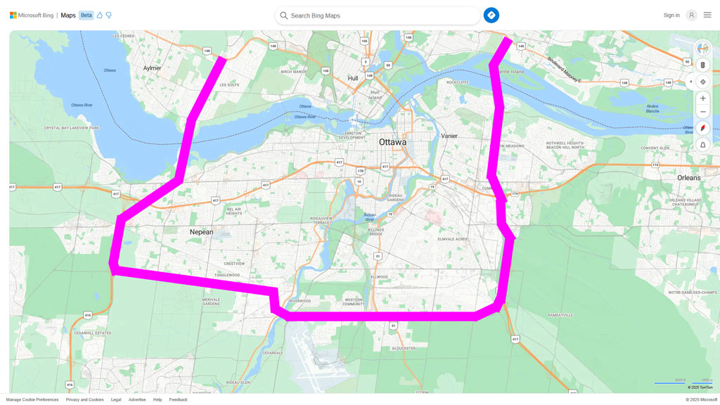
Councillor pushes Ottawa ring road instead of 6th bridge
City committee endorses motion urging higher levels of government to look at idea

Arthur White-Crummey · CBC News
Posted: Jun 26, 2025 4:50 PM EDT | Last Updated: 1 hour ago


A city councillor says Ottawa needs a southern ring road to relieve congestion on the Queensway — instead of a controversial bridge over Kettle Island.

Beacon Hill-Cyrville Coun. Tim Tierney floated the idea at Thursday's public works and infrastructure committee meeting as councillors debated updates to the transportation master plan, a guiding document setting out infrastructure priorities for the coming decades.

Tierney noted that Highway 417 is currently the only major east-west route for interprovincial and regional traffic, including trucks, which should be rerouted south of the urban core.

He made a motion, which passed by a vote of 9-2, urging all levels of government to pursue a "full and fair evaluation" of a southern ring road. The motion will now go to council for a final vote.

Tierney said it sends a clear message.

"We're saying this is really important to us," he said. "If the province is looking for some guidance for where they would like to provide some money to the city ... we've just indicated, it's this — it's not an interprovincial bridge."

<more>

https://www.cbc.ca/news/canada/otta...awa-ring-road-instead-of-6th-bridge-1.7571935
 
img_7208.jpg
 
It's not a terrible idea... With population growth, 417 traffic continues to become worse and worse with little alternatives for drivers as the other limited cross town routes (Baseline, Hunt Club) are already so congested and have so many traffic lights.

I feel like the bridges were our chokepoints pre-pandemic but I personally feel bridge congestion has eased up quite a bit since WFH and travel patterns have shifted.

As someone who walks the stretch of Rideau St from Nicholas to King Edward almost daily, I can assure you the truck and vehicle traffic has not decreased one bit.

Aside from trucks, cars filtering from all directions into the same area to cross the Interprovincial bridge is unbelievable. I watch it stop and crawl every afternoon from my balcony.

A new bridge is needed. It was needed 20 years ago. World class cities (with many politicians claiming or dreaming Ottawa is in this club) do not have multiple logging, fuel, freight trucks running through their downtown cores.

This councillor is deflecting.
 
As someone who walks the stretch of Rideau St from Nicholas to King Edward, I can assure you the truck traffic, and vehicle traffic has not decreased one bit.

Aside from trucks, cars filtering from all directions into the same area to cross the Interprovincial bridge is unbelievable. I watch it stop and crawl every afternoon from my balcony.

A new bridge is needed. It was needed 20 years ago. This councillor is trying to deflect because a new bridge has an affect on a small portion of his political base.

Weird how in every other thread it's understood building more stroads doesn't reduce congestion but this bridge is somehow different.

Congestion is good if it gets trucks to avoid this route. I see more and more from Montreal on the 50 for example which as it's twinned more and more will become the main Montreal to Gatineau route. Add this bridge and that becomes less true.
 
How does a ring road address the same problem as a bridge? I am a prepared to discuss it if the ring road is placed right next to Beacon Hill.
 
How does a ring road address the same problem as a bridge? I am a prepared to discuss it if the ring road is placed right next to Beacon Hill.

My question exactly. Tim seems to be selling this as some sort of alternative, but a ring road, unless you cross it to Gatineau and plug it into the A50, doesn't solve the truck traffic in Lowertown.

And Fortier going to bat for Manor Park. She knows she represents Lowertown as well right? Lowertown with far more population and density.


Back
Top