noirish Los Angeles


Status
Not open for further replies.
:previous: Sad news, M P. :(


Thanks for figuring out the location of the Los Angeles Ignition Works, Hoss and odinthor. I appreciate your help.

We haven't seen Bourston's on NLA. (I searched)


eBay


The photograph inside of the folder is of three sailors.


Sometimes there are dates on the back of the folders but this one didn't/doesn't have a date.


I'll take a swing in the dark and say the 1940s. ;)
.

How could they have their own location printed on the souvenir photo holder incorrectly? It's Slauson at Van Ness, not Slauson at Van Nuys.

 
Last edited:
:previous:


Two Bourston's ads from 1942 and 1946 and the name change to the Mellodee Club in the Fall of the latter year.


Em2HmPT.jpeg

cdnc.ucr.edu - Southwest Wave, 2 January 1942/18 April 1946/ 31 October 1946
 
Ding! Ding! Ding! We have ourselves a mystery location.

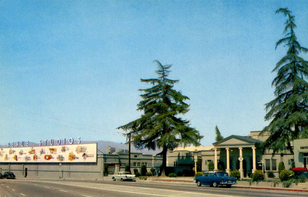
This slide just popped up on eBay.


Seller's description:.."Vtg 1961 35mm Slide - TV Studio Logos Sign - Johnny Midnight - Los Angeles."

Does anyone know what tv studio this is?


eBay

There appears to be stand-alone letters at the top which seem a bit unusual.

The stand-alone letters spelled "REVUE STUDIOS", the company that made 'Johnny Midnight'. The studios were on Lankershim Boulevard in Universal City - roughly here. There's more info about Revue Studios on Wikipedia.

1b81fb08-ad60-444c-a6b1-a06fb0a0c0ff.jpg

valleyrelicsmuseum.org
 
We haven't seen Bourston's on NLA. (I searched)


eBay


The photograph inside of the folder is of three sailors.


Sometimes there are dates on the back of the folders but this one didn't/doesn't have a date.
I'll take a swing in the dark and say the 1940s. ;)
.
_______________________________________________________________

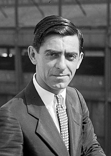
The sailor on the right reminds me of Eddie Cantor, aka Isidore Itzkowitz.
220px-Eddiecantorportraitcrop.JPG
Wiki

I'd never come across an "AX" exchange phone number before.
Stands for AXminister. (Leimert Park) According to Los Angeles Almanac's "Old Telephone Exchange Names in Los Angeles County, California" page.
 
.
Ding! Ding! Ding! We have ourselves a mystery location.

This slide just popped up on eBay.


Seller's description:.."Vtg 1961 35mm Slide - TV Studio Logos Sign - Johnny Midnight - Los Angeles."

Does anyone know what tv studio this is?


eBay

There appears to be stand-alone letters at the top which seem a bit unusual.

:whip:

Sally forth o' loyal plebes!

.

My guess, based on the shows, which are all on local Los Angeles Station in 1959/1960, that the building was on Talmadge at the for ABC Television Center, now The Prospect Studio owned by Disney.
 
.
How could Bourston's have their own location printed on the souvenir photo holder incorrectly? It's Slauson at Van Ness, not Slauson at Van Nuys.
Good eye, BDiH. I wouldn't have caught that.


Originally posted by Noir Noir


My sister used to make me Jitterbug with her when we were kids. I had to be the girl because she wanted to twirl me around like a rag doll and slide me back and forth between her legs.
I've been in therapy ever since.


Originally posted byNoir Noir


Not to be confused with the Melody Room on Sunset.


instagram/alisonmartino


re: REVUE Studios.

Thanks for figuring out the location of the mystery slide from eBay, HossC.


Here's a bit more information.

hauntedstudios

How confusing is that!


Oh, & thanks for the quick clip, M P.


It certainly brought back good memories. :)

.
 
Last edited:
.
In need of verification.

A stunning ORIGINAL photograph just showed up on eBay.


I've blown it up. (Kapow!)


eBay

As you can see it's quite stunning but is it really Santa Monica?


I decided to go ahead and post some details for closer inspection.

#1


#2


#3 I'm especially curious about the structures under my arrows.

I have no idea what that is.


#4 This one appears to be round like a wire corn bin.


Here's an example for you city slickers.


Back to the initial question: Is this Santa Monica in 1904 like the seller says it is?

.
 
Last edited:
:previous:

I'd say "Yes, it is Santa Monica".

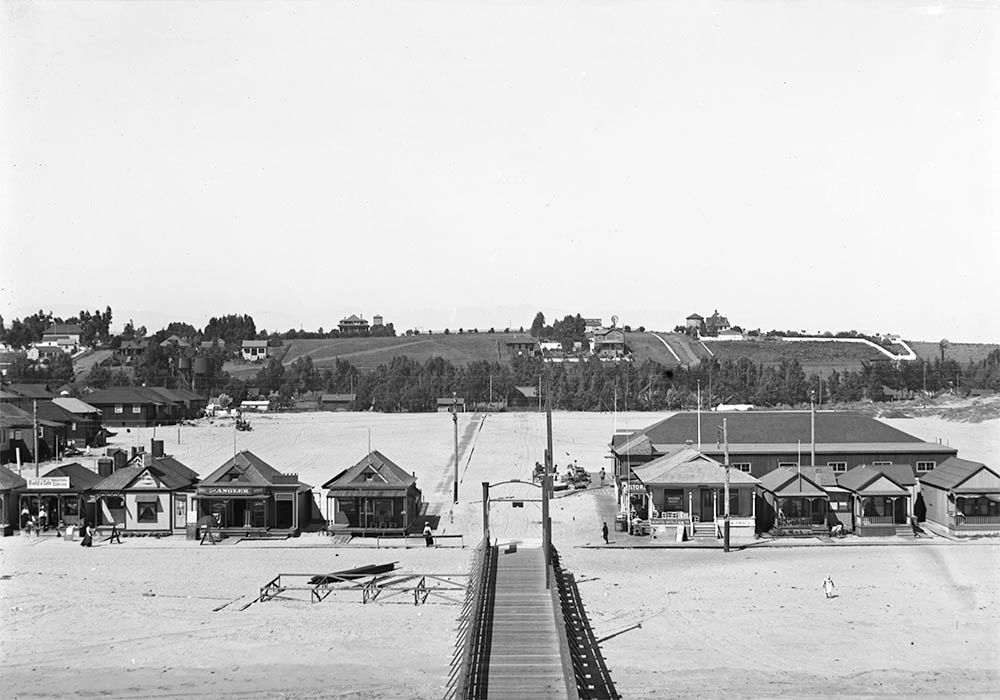
I found the picture below through the Water and Power site. It was originally in the USCDL when they had huge photos (the link below the image takes you to the large image).

Small homes and businesses on Ocean Park beach at the pier, ca.1900

afd05b10-7245-420a-b420-281ff8033c40.jpg

wikimedia.org

Some background from Water and Power:

In 1891, Abott Kinney and (silent partner) Francis G. Ryan purchased a 1-1/2 mile long, narrow strip of sand dunes along the shore line south of Santa Monica extending from Strand Street to Brooks Avenue from a Captain Hutchinson. To encourage building, water was brought in, the tract was sewered, board walks laid, and lots leased to persons desiring to put up small cottages.

That same year, Kinney & Ryan (Ocean Park Development Company) built a pier, golf course, horse-racing track, boardwalk and other resort amenities on the northernmost edge of their holdings. They would also give 12 acres to the Santa Fe Railroad so they would extend their Inglewood line north to Kinney and Ryan’s resort.

In 1893, Kinney and Ryan began selling small 25 x 100 foot beach lots priced at $100 and featured piped water. Tents were erected on the unsold lots and were available to campers for summer rental. Frederick Rindge, who was president of the Los Angeles YMCA, founds a YMCA summer camp on 5 acres of land located on 250ft beach front near Hill St., donated by Kinney who hopes that the YMCA camp will attract people to his beach resort.

Kinney and Ryan’s original resort consisted of 150 beach cottages, and a small commercial district along Pier Avenue. A building boom added 40 new beach cottages, several stores, and Kinney’s new 40 acre Ocean Park race course and golf links. The resort would be subdivided and sold to more developers and by 1902, there were over 700 cottages in Ocean Park.


This text seems to have originally been published at oceanpark.wordpress.com.
 
Water Tanks ??

.
In need of verification.

A stunning ORIGINAL photograph just showed up on eBay.


#3 I'm especially curious about the structures under my arrows.

I have no idea what that is.


#4 This one appears to be round like a wire corn bin.


.

I believe these a private water tanks for certain residences. There seem to be a couple or three here:

AkxJX5b.jpg
 
.
HossC, thanks for vertifying the Santa Monica photograph from eBay. :) I appreciate it.

What confused me about the photograph was the gently sloping hill in the background. I am so used to seeing photographs of the 'cliff' area north of the S.M. Pier . .I became befuddled.


I believe these a private water tanks for certain residences. There seem to be a couple or three here:

AkxJX5b.jpg
_________________________________________________________________________________________________________________________________________________________________________


:previous: Engineeral, it appears that you are correct about the structures being water towers. (in this particular spot in the photo)

I've enlarged and lightened the image.


but this structure seems eccessively BIG to be a water tower, especially for a single home. . .which it appears to be.


Maybe they drank alot of water. :-O

.
 
Last edited:
.
. . . . . and while wer'e in the Ocean Park area of Santa Monica.


Has anyone heard of Taftland?


old file / found on eBay


Here's a closer look at the home at the top.


I wonder if this was actually built?


The photographer's stamp on the reverse -for good measure.


update:

I just found this in my file as well.


.
 
...

but this structure seems excessively BIG to be a water tower, especially for a single home. . .which it appears to be.


Maybe they drank a lot of water.

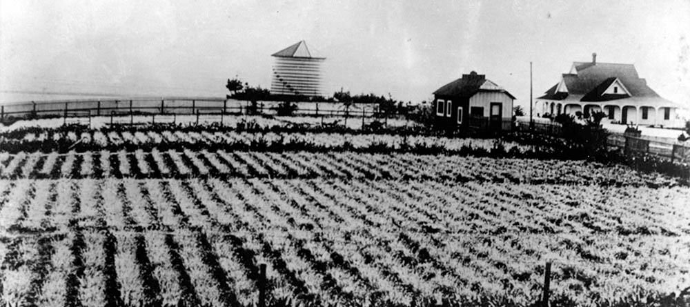
Here's another picture that I found at the Water and Power site. That site retains the original large image, while the quoted source, now santamonicahistory.catalogaccess.com, only has a small watermarked version. There's also a differently framed version at the Santa Monica Public Library.

The santamonicahistory site does, however, provide this excellent description which I think explains the mystery structure:

Carnation field, silo, and a home, located at 4th Street and Marine Street in the Ocean Park neighborhood of Santa Monica. The property belonged to Edwin J. Vawter, a pioneering Santa Monica businessman. A 1901 guidebook ("Wilson's Illustrated and Descriptive Souvenir and Guide to Los Angeles and Near-by Towns") described the field thus: "One of the most beautiful attractions [in Ocean Park] is the carnation field of Mr. E.J. Vawter. It is situated on a ridge overlooking the grand old Pacific. Here carnations are in full bloom summer and winter."

8f2c8607-268c-4641-ae3d-f9c6c02e5c71.jpg

santamonicahistory.catalogaccess.com
 
^^^
Nice! We've heard of the Poinsettia fields on NLA, but I'd never heard of the Carnation fields. What a great color photo that would make!
---

Speaking of the Poinsettia fields, some things about that I'd looked up recently...

0ab8563df71137ad8218a9295c9d4e13.jpg

Bloomin'News/ISSUU


This photo is from Beverly Hills Heritage: An other worldly view of the poinsettia fields of Paul Ecke's farm in West Hollywood (then Sherman) that overlapped
into the city of Beverly Hills between Sunset Boulevard and Doheny Road, c1932. You can see the bridle path down the center of Sunset and the edge of the
Doheny Ranch orchards in the upper left hand corner of the photo.

464143213_8737746119616024_12577404923276983_n.jpg

Beverly Hills Heritage

The Ecke family first lived in Eagle Rock and then moved in 1906:

90
PBS SoCal

^^^
The street name was later changed to Hayworth Avenue and the area later became known as Sherman and then West Hollywood.
(Sunset Blvd. and Hayworth Ave. is now where the DGA is located.)


This is an interesting find! All the writing on the photo is as follows:

Top: "New Hacienda in distance just ready for occupancy." (And an arrow to the building. Wonder if it's still there?)
Bottom: "12-25-27. Looking East from roof over poinsettia fields."

This photo was added in the article's comment section by a person named Linda Wilder, who writes: Photo 12/25/1927 taken by B.F. Shrimpton from roof of home at Sunset and Horn Avenue.

7E0CBE1E-36CD-4DCD-A190-EA9F87F2BC46-1671831390.5049.jpeg

WeHoOnline
 
Last edited:
.
:previous:
Thanks for the follow-ups on 'Taft Land', HossC and odinthor. . . and about the Poinsettia fields in Hollywood, M P. It was all really interesting.
___________________________________________________________


Martin Pal initially posted about the upcoming destruction of the Hollywood Center Motel, Here.


Now there is a 2nd video on YouTube concerning the motel which includes scenes such as this one from 1971.

screen-grab


Here's the actual video for anyone who would like to watch it. (it's 20 minutes long)

• Video Link


.
 
Last edited:
Status
Not open for further replies.


Back
Top