(ETA: Added a couple of notations on the included pictures, a new "Now" version of the "Italian Stores" shot, and in the North Spring photo, an inset showing camera position and FOV.)
TL;DR version: I found a
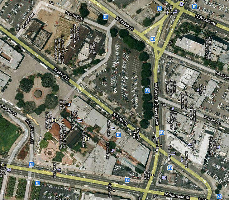
photo of the small block bounded by North Spring, New High, and Sunset Boulevard, now a forgotten piece of L.A. history long since obliterated by the giant El Pueblo parking lot at 601 N. Main. Picture is also displayed in an image tag below. You can read my comments on the Flickr page; for full picture credits and a more detailed discussion, read on.
Quote:
Originally Posted by Beaudry

Amazing find. Thanks gsjansen. I knew I'd seen the Bamba before -- the Sins book says it's on Main, but we know better, eh?

The question then is What happened to North Spring? The addresses on the 600 block, today, don't begin til 638...hmmm...
Now you see it:

Now you don't!
Our old friend the Jalisco (once upon a time in the Sentous Block, which fronted on Main) is now a ghost living in the middle of a parking lot. |
I don't know if this has been answered yet, but a couple of days ago, just by luck, I happened on the answer, plus a view I don't think we've seen here before.
On another message board community, a poster pointed out that the plat maps created and used by assessors often reveal old street alignments, and went so far as to compare it to an X-ray.
He wasn't far wrong, as I found out when I went to the County Assessor's website's
property database, and noticed that three oddly shaped parcels still mapped, right in the middle of that giant parking lot. Here, we see only the largest and westernmost of the three highlighted:
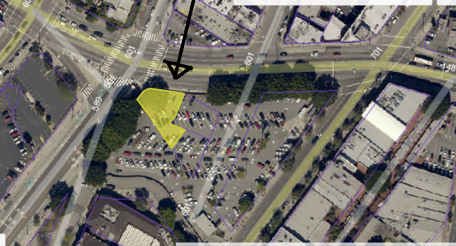
(From the L.A. County Assessor's website)
No address, and no build dates, of course, but that's to be expected since there are no structures. But there used to be some buildings there, as we'll see.
But wait, there's more.
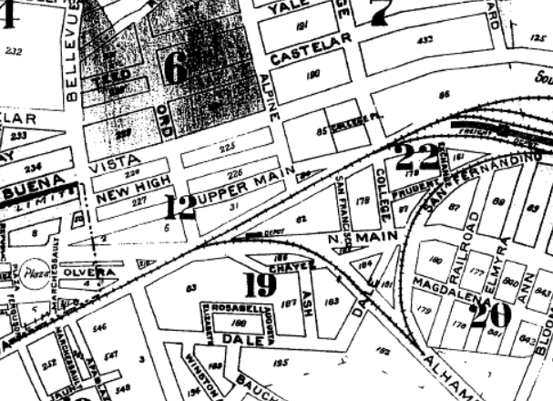
Switching from the satellite to roadmap view, we begin to understand what happened with Spring, Main, and New High streets. It's mildly astonishing that the database still records the old street alignments that vanished more than half a century ago. Although this appears to be based on Google Maps, Google itself doesn't provide this interest bit of knowledge.
We now see that North Spring used to run east of New High, which it still does, but the modern alignment throws us off because today the nearly obliterated stub end of New High starts below the modern Spring Street alignment. South of Sunset/Chavez, Spring was rerouted about a block west. The original alignment resumes north of there, so that through New Chinatown both New High and Spring resume their old routes. This should surprise nobody, since that neighborhood still boasts a few buildings from the late 19th to early 20th centuries which are still clearly sited on their original streets.
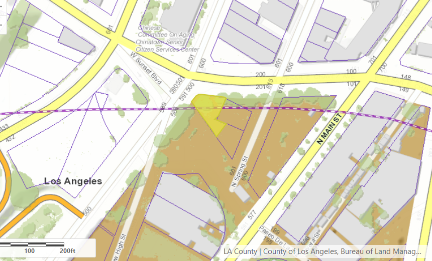
(From the L.A. County Assessor's website)
Curiously, the plat map, shown in the next picture shows both the new and old alignments of Sunset Boulevard, now duly relabeled in honor of Cesar Chavez.
(From the L.A. County Assessor's website -- better resolved image available
here.)
and again we see that weird triangular area comprising three parcels.
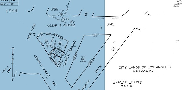
As to the street address of the Sentous Block, the North Spring address is correct, as shown on the Baist map. The confusion with North Main comes from the fact that North Spring, like so many other streets, underwent not only realignment, as noted above, but also a flurry of name changes. In the 19th Century it was Upper Main, and was distinct from North Main, which was where it remains today. IIRC in those days there was a rise in elevation, hence the very confusing name for what we would now call North Spring, if only this block of it still existed.
(Sanborn Map, access provided by the San Diego PL.)
For a few years early in the last century, it was San Fernando Road, but by the time of the 1921 Baist survey, it had become North Spring. From that map, it does appear that all of these parcels fronted both North Spring and North Main. Did the
Sins book give an even numbered address for the Bamba? It's not difficult to imagine that they could have managed valet parking and taxis on the Main side. The situation with the Sentous is similar, though given its build date, it could have been listed, at various times, on "real" Main Street, or Upper Main, or North Spring.
And now let's go back to those parcels in the middle of the parking lot. I found a photo in the LAPL collection taken from the west, dated April 9, 1940 according to the catalog entry.

(LAPL photo collection, order number 00104245, q.v. if you don't see the photo immediately above.)
The Italian Stores Company was a small chain of grocery stores that had several locations in the DTLA area. This one appears in the 1934 City Directory, listed at 229 W Sunset, corroborating well with the Baist survey map image in
Beaudry's post.

(Los Angeles City Directory for 1934, classified section, p2534. LAPL Visual Collection)
Later, the grocery store moved out and a restaurant called O Sole Mio moved in. Identifying the type of restaurant is left as an exercise for the reader.
Obviously, this address was on the original alignment, where we see Sunset veering off to the right. The Baist map lists a couple of hotels in this block, but I was unable to find any of those listed in any of the directories. Possibly they were boarding houses run by landladies who only took in boarders with references, and preferred not to announce their presence to all and sundry.
To the left of the Italian market, we look down Bellevue Avenue, somewhat close to the present-day alignment of Sunset/Chavez. The Bamba Club, one door north of the Sentous Block, is partially visible in the distance. ETA: In the far distance, at the very right margin, we can see the Fook Wo Lung building standing on the southeast corner of Los Angeles and Sunset/Marchessault, and dwarfed by the gasometer behind it. This building was home to the Dragon's Den Restaurant.
As we let our gaze continue along Sunset, we see the south end of that narrow block between North Main and North Spring; the building there is the Pacific Hotel at 608 1/2 North Spring. Just north of there was the Hotel Atlantic, with the Sentous building just beyond that. If we could wander on down Sunset and turn left at North Spring, then wander up to the other end of the block, this is what we'd see if we turned around:
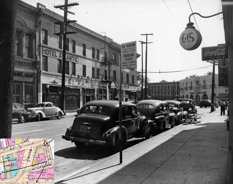
(LAPL Photo Collection, order number 00014327, q.v. if image doesn't appear here. Inset from the 1921 Baist map, showing approximate position and FOV of camera, added by me.)
At once we're struck by the abundance of hotels; nearly every other building seems to house one. The demand for cheap lodgings, given the neighborhood population of the era which skewed heavily transit dependent and working class, was vast and deep. The decade following these images brought about a major change, as a result of which the neighborhood now skewed heavily towards --
nothing. NYC has Tribeca; San Francisco has...well, San Francisco; and Chicago has the Near North Side. Even San Diego has the Gaslamp. But in L.A. we've got a half-dozen parking lots and a few architectural remnants--and, of course, relentlessly regularized boulevards.
If we could keep going down Sunset, we'd cross Main and then the north end of the Plaza, immediately south of the Simpson Building, Olvera Street, and the Methodist Church. There was a time when the Plaza Church, now addressed on the west side of Main, and the Plaza Methodist Church both had Sunset Boulevard addresses, W and E respectively. Going still further we'd pass the last remnant of Old Chinatown on our right, and then straight across Alameda into the main entrance of Union Station.
Having seen all of these images, it is impossible not to feel resentment, nay, a simmering
rage, at what has been lost, and for nothing more than a parking lot. Here we see images from a time when this neighborhood possessed a certain vigor and was full of crazy-angled streets and old architecture--a sort of Southern Californian
Altstadt. In hindsight, it seems that this neighborhood, in particular, became the poster child of the suburbanist urban renewal ethos of making Downtown America car-friendly and everything-else-unfriendly. Another factor, perhaps, was a priggish urge to rid the neighborhood of "unsightliness", including any evidence of nightlife like the Bamba, and for that matter the working people who lived here along with the cheap hotels and other businesses that catered to them. The neighborhood was going to be cleaned up, and if it meant total destruction, then so be it. We couldn't have busloads of school children coming down here to see Olvera Street and let them see
that, could we?
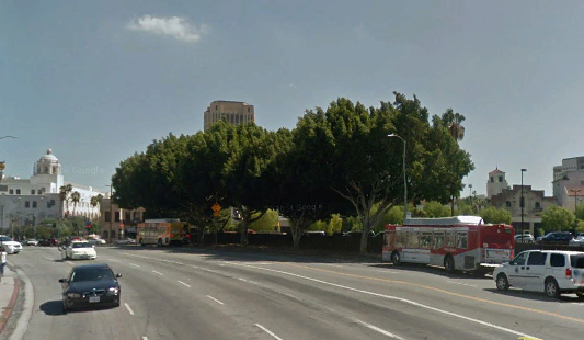
ETA: An approximate "Now" version of the above picture:
(GSV Screengrab)
Nearly everything in the 1940 picture has been bulldozed, revealing at extreme right the the Plaza Substation, and at left the entire elevation of the Terminal Annex, where before only the top of the tower could be seen.