 Posted Oct 29, 2019, 9:59 PM
|
|
Registered User
|
|
Join Date: May 2010
Posts: 8,479
|
|
Quote:
Originally Posted by K-Man

MYSTERY BRICKS - POSSIBLE REMNANTS OF THE ORIGINAL NORTH STREET STATION RETAINING WALL?
So I've overthought this. But, with all the railway discussion lately I thought I'd throw these up just for a fun post. Over the summer I was down at "ground zero" where the North Street Station once stood. The whole area is now just a parking lot with a cement retaining wall along Barrington St. but halfway down there is a natural outcrop of ironstone rock that pops out. And within that section of rock are the remnants of what appear to be an old brick wall. The small patch of cement and rock are very reminiscent of the "old Halifax" style of building using random course ironstone. In the 'zoomed in' image below of the station you can see how the original retaining wall looks like it was built on top of the natural rock much like the small patch of brick work in question.
I wasn't sure how large the footprint of the North St. Station used to be so I placed google maps over plate 't' of "ol trusty" (Hopkins Atlas) lining up North & Barrington streets on both maps. Admittedly I was a little disappointed to see that the section of brick work was a lot farther away from the station than I had thought. In the first image below you can see the footprint of where the station once stood (red), where Upper Water St. used to end (orange), the location of the brick work (arrow), the Wellington Barracks magazine where Atlantic Fleetclub is today (red), and just for alignment/reference the Admiralty House & it's circular driveway (purple). I have to say that for a hand drawn map at a time when aerial photography was not available it's remarkable how accurately the streets/buildings on Hopkins map line up with the current day streets/buildings on google maps.

Source: Google Maps - https://www.google.ca/maps/place/Bar...!4d-63.5883149

Source: Google Earth - https://earth.google.com/web/@44.662...8.98718623t,0r
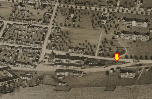
Source: https://www.loc.gov/resource/g3424h....,1.473,0.568,0
**The image above is a section of Albert Ruger's "Panaromic View of the City Map - 1879". I've discovered that this is an excellent "side kick" to use with Hopkins Atlas when you want a 3D image of the buildings from that time. Even though this map is also hand drawn it's amazing how accurately the buildings align with Hopkins map.
Anyway, this is most likely some recent patch work BUT I will say that the original railing along Barrington St. did manage to stay in place for years (even through bridge construction) so who knows, maybe it really is an original section of wall. I know the images below have been posted before in a thread that I can no longer find about the North St. Station but I thought they were just too cool to not re-post as they show the last remnants of the station.....or do they? 
Date: 1975

Source: Noticed in Nova Scotia - https://halifaxbloggers.ca/noticedin...h-end-halifax/

Source: HRM Archives - http://gencat1.eloquent-systems.com/...OI1_1225%3D827 |
One more photo to add, of North Street Station and the same railing, from almost the same vantage point as the last photo, post-explosion:
 Post Explosion photographs
CR 58-2.8: Beside North Street Station. Afternoon of explosion.

|