A few months ago I started a project that involves mapping recent development in some of the largest cities in Canada, and some smaller ones that might be interesting, starting with Ottawa-Gatineau, the City of Vancouver, and the City of Toronto. The first one that I fully completed was for Ottawa-Gatineau so I thought I would share it here since I think it gives some pretty interesting insights into how the city developed from 2004-2018.
Before I get into the maps, a few quick notes. The data showing development was created by myself, in Google Earth Pro, with the use of Streetview for verification from time to time. The maps themselves were created in QGIS, and the rest of the data came from StatsCan, NRCan, and the City of Ottawa. While it would have been ideal to map a date range that also corresponded with census years, to really do some interesting analysis, the range I picked was ultimately decided by the availability of high quality satellite imagery that would properly allow for changes in land use and building types to be determined.
For many of the maps I will post two versions, a day time, and a night time version. They contain the same development data, but each has its own strengths in terms of what it shows. In addition to the images posted in the thread, there are also links to high resolution versions of the maps (which I encourage you to click as they allow a lot more detail to be seen).
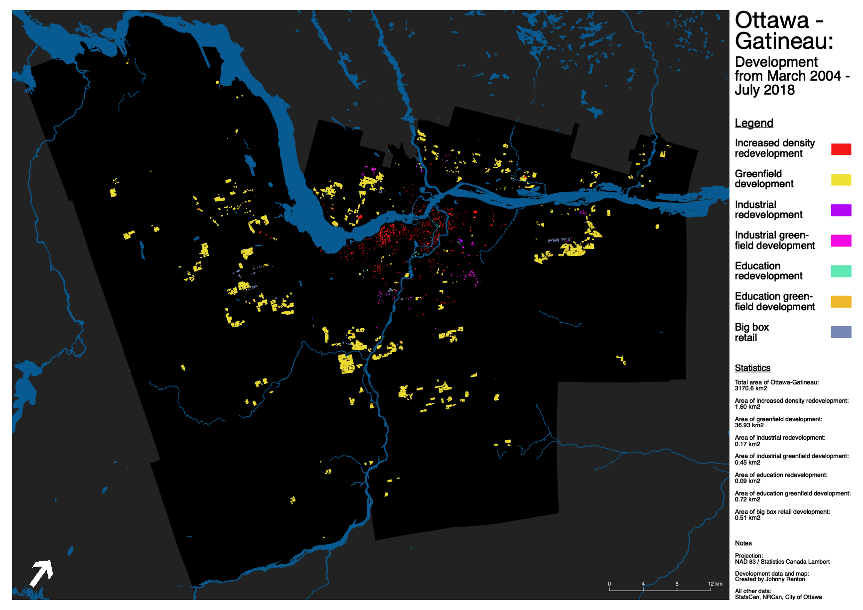
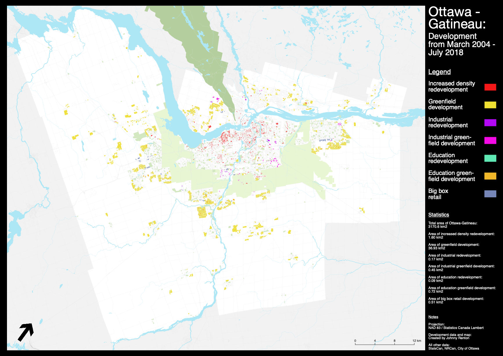
So lets start with by looking at all the development types on a single map.
 High resolution night time version.
High resolution daytime version.
High resolution night time version.
High resolution daytime version.
There are some interesting things to point out when it comes to redevelopment in Ottawa-Gatineau. One, there is very little redevelopment taking place in Gatineau. Zibi will essentially be equal to amount of development Gatineau had seen in its central area for the past 14 years.
Two, there are some areas of Ottawa that are surprising in terms of their lack of development. Few would be surprised to see The Glebe having minimal change, but Centretown and Lowertown are equally lacking in this regard. Even the CBD area has seen tepid change, at best.
The final note is that you can quite easily see where the federal lands are, since they are the areas that have seen the least amount of redevelopment. LeBreton Flats has been pokey, while land parcels/districts like Tunney's Pasture and the Billings Bridge/Heron area have remained frozen in time, despite being in critical, desirable, central locations.
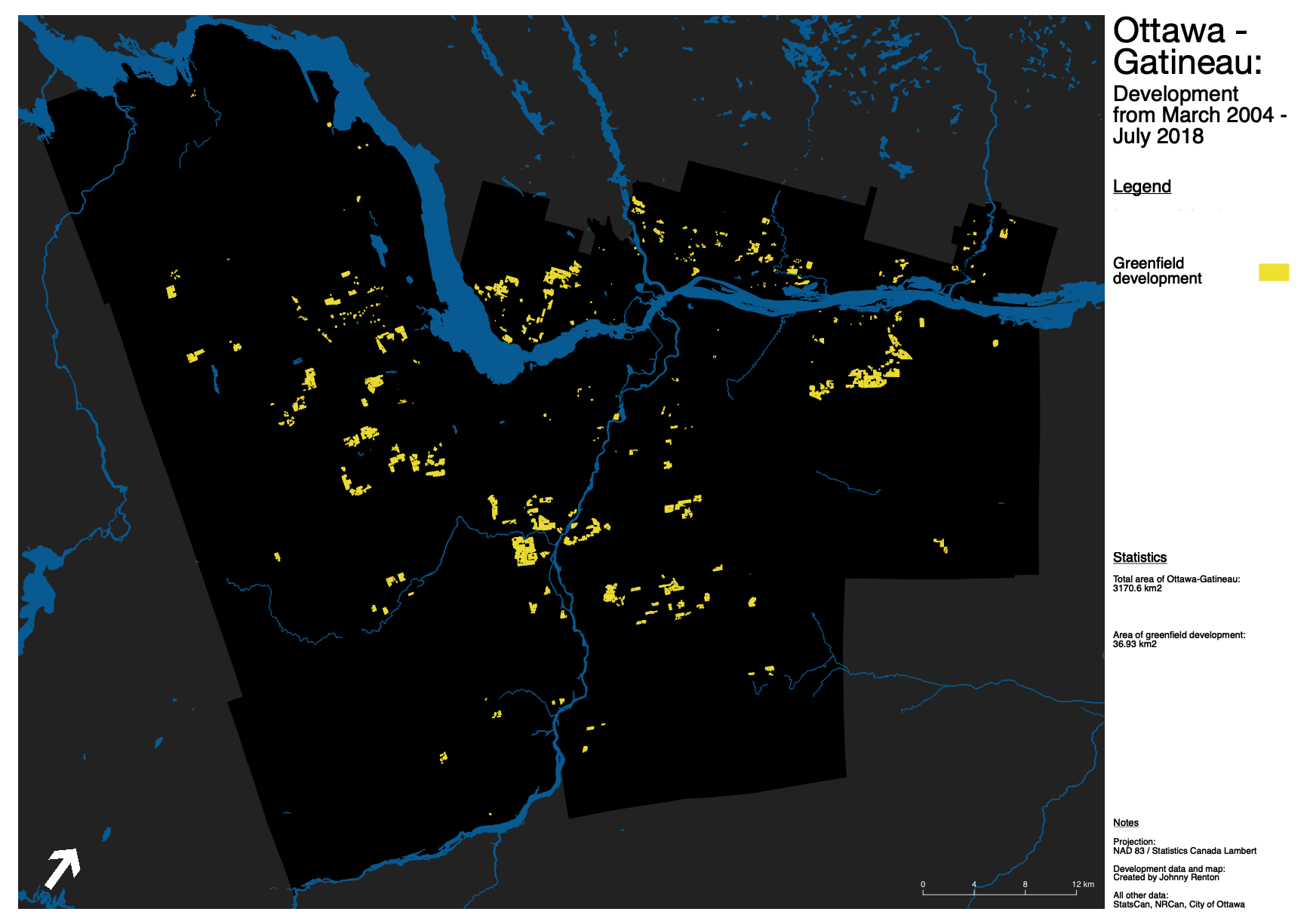
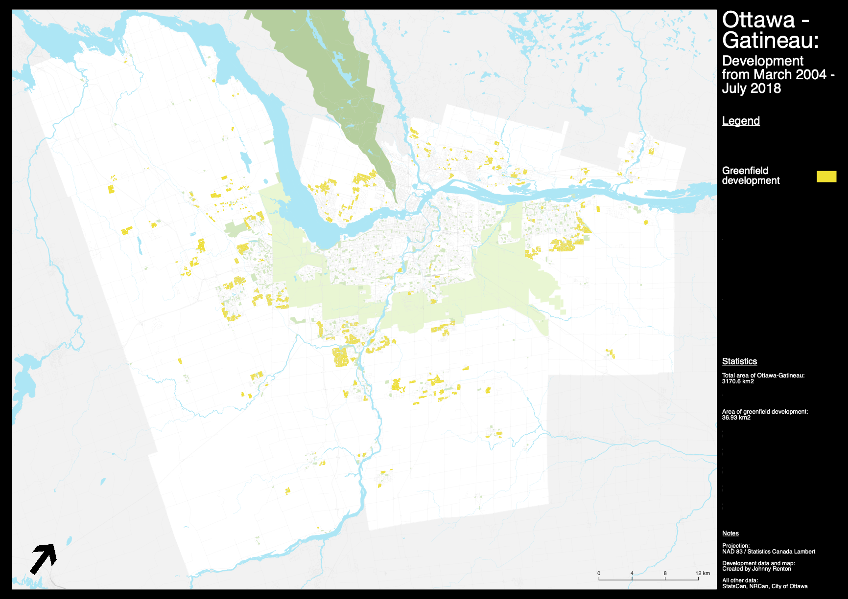
Next, let's take a closer look at greenfield development across the NCR.
 High resolution night time version.
High resolution daytime version.
High resolution night time version.
High resolution daytime version.
The total amount of greenfield land that was developed into residential and commercial properties was 36.9km2. That doesn't include roads, sidewalks, or other public right of ways. A typical city has 30-40% of its land used consumed by roads, sidewalks etc. So when you factor in those land uses, at the conservative rate of 30% land use, this means about 52.7km2 of former agricultural or natural space went to new development.
This means that for every 1 km of land that was redeveloped into a higher density use, at least 27km of greenfield space was developed.
Also of interest is how much of Gatineau's greenfield development is taking place in Aylmer and Le Plateau. And given that it is actually fairly close to the centre of Gatineau (and downtown Ottawa), and with a plan for LRT, and a surprising amount of bike lanes, you could argue that it is probably the least offensive greenfield development in the region.
The last thing I will point out is the amount of exurban development in the southern part of Ottawa, and north of the primarily residential agglomeration in Kanata. Ottawa is unique in that the city is actually primarily rural, so a lot of that development would normally take place in adjacent cities/municipalities in other metro regions in Canada. If some of the municipalities next to Gatineau had been included you would see that trend on the northern side of the Ottawa river as well (so that it is clear this is not just unique to the Ottawa portion of the NCR). So while this map does not show the full extent of the exurban trend, it is very much a factor in the amount of greenfield space which is being consumed for development.
For the next development categories, I will post each of their individual maps at once. I will also only be posting the night time versions to this post, as the minimal amount of geography they cover means the daytime versions only convey the information well in full size form (which I will include links for).
 High resolution night time version.
High resolution daytime version.
High resolution night time version.
High resolution daytime version.
 High resolution night time version.
High resolution daytime version.
High resolution night time version.
High resolution daytime version.
 High resolution night time version.
High resolution daytime version.
High resolution night time version.
High resolution daytime version.
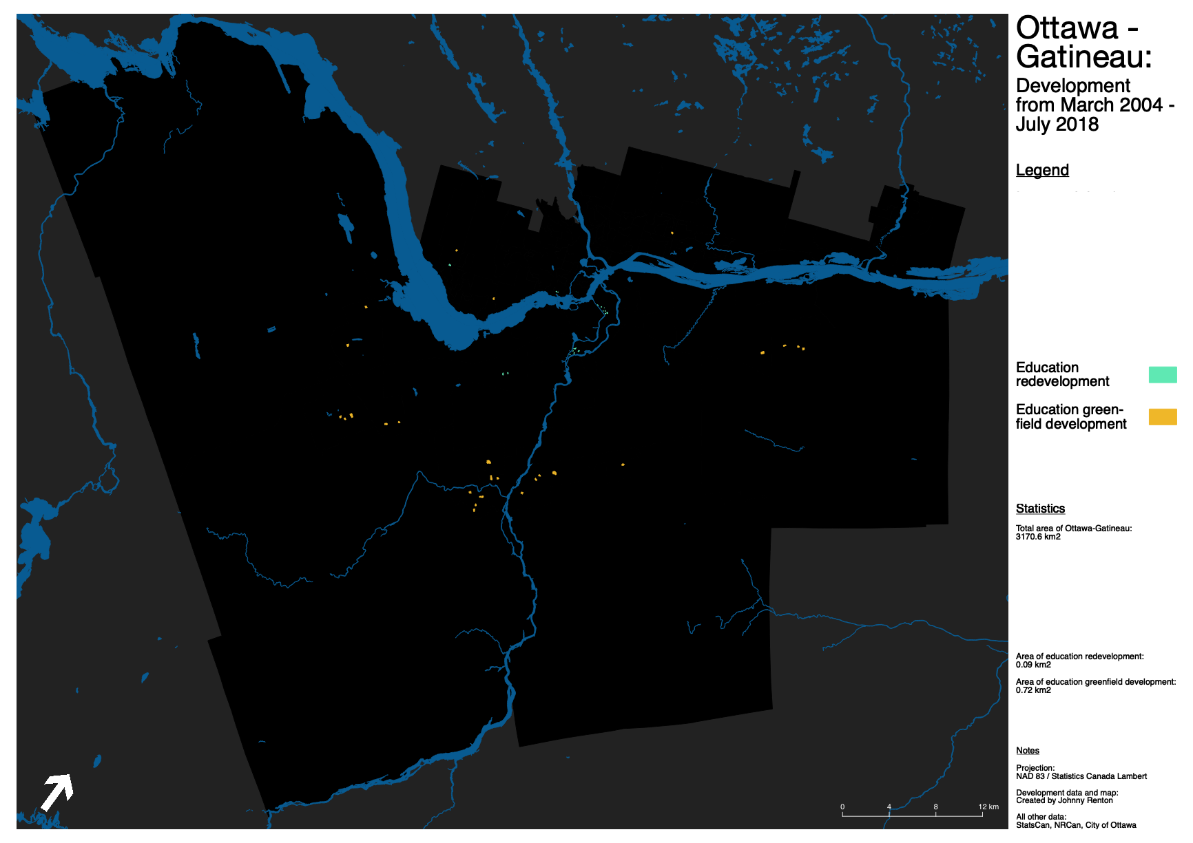
When it comes to the education sector, there isn't much surprising here. Inside the greenbelt, development was almost exclusively post-secondary institutes expanding their campuses. Outside the greenbelt, it was the construction of new elementary and secondary schools. Of the new schools that were built in Ottawa, a majority were in the Barrhaven and Riverside areas, a testament to the amount of families who have purchased homes in that particular area.
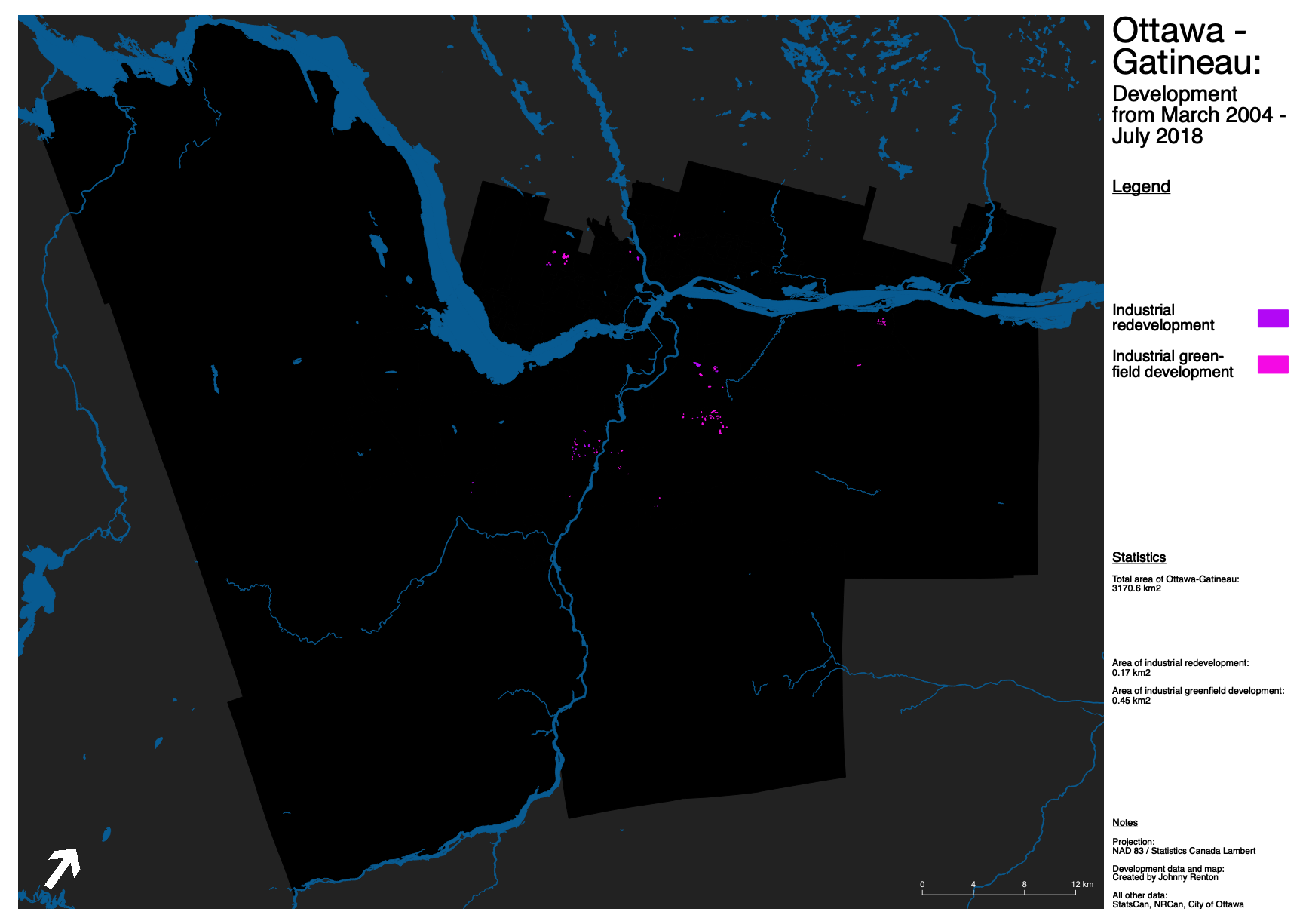
Industrial development and relocation is something I am quite interested, and I mapped it in Ottawa to see if perhaps there were any kinds of major shifts (like what is being seen in the Toronto and Vancouver areas). I didn't really see any trends worth noting. This could change in the next 10-15 years, though I really don't see that happening as the kind of redevelopment pressures needed to push industry into new areas of the city just doesn’t seem to be there.
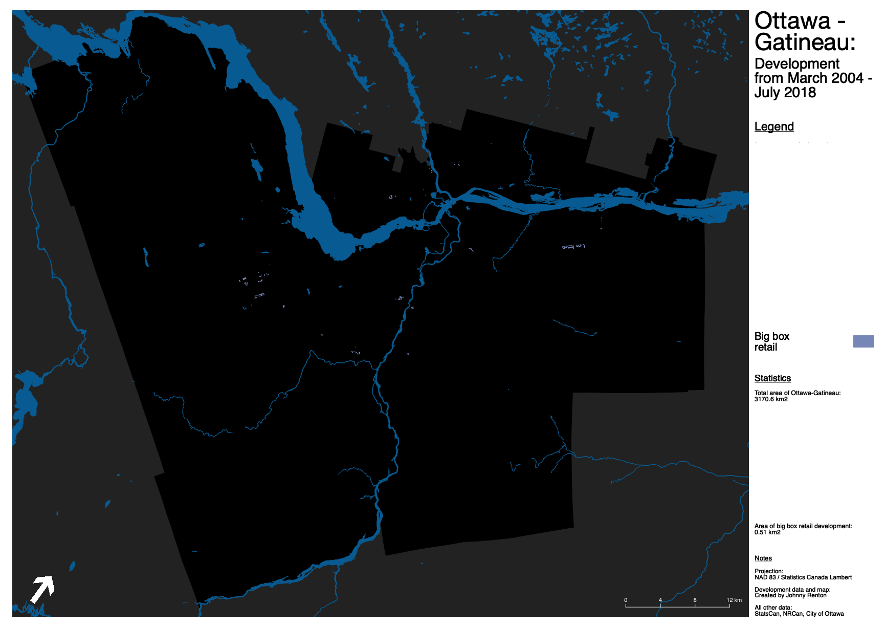
The last map is for big box retail redevelopment. It is worth noting that parking was not included in the area that was mapped. It was only the buildings footprint and associated outdoor spaces (like loading zones). In a future version I would like to also have a separate category for outdoor parking, as that would be interesting to see just how much land parking uses, with each associated development type, but that was not included this time around due to time constraints.
I won't go into much more detail than that right now. This is not the end of this project. As I mentioned above, I will be doing this for other cities, and I will be doing much more detailed spatial analysis within the GIS software in the future. You might notice that transit was not included on the maps. This was because I couldn't find a data set that was going to work with the analysis that I want to do in the future. So instead of adding a placeholder, just to have it, I opted not to include it until I have the exact data set I require.
A few final thoughts on development in Ottawa-Gatineau. While I was never delusional about how much suburban development is still the dominant form in the region, I was still surprised at just how extensive it was. Yes, there has been some redevelopment. But a lot of it is limited to single family homes becoming duplexes, with central neighbourhoods, like Centretown and the CBD really not growing at the rate I had expected.
I wouldn’t go so far as to say that Ottawa has failed, but more along the lines of “Ottawa hasn’t really done all that well at urban growth". The results of the past few decades of planning policies and transportation strategies are clear. Maybe LRT will start changing the equation? At the very least I suspect that the area west of Westboro, along the Ottawa River, is going to be the next redevelopment hotspot. And projects like Zibi could help add a needed spark to central Ottawa and Gatineau development. But perhaps the biggest elephant in the room are the federal lands. These are far and away the biggest opportunity for Ottawa to add more density within the greenbelt. They dont even have to be home to be 20 storey towers either. They could be mid-rises and residential blocks that have a more Reykjavik scale to them. And right now, their potential is being wasted.
And none of this is a knock against Ottawa. It is the most underrated city in Canada, and other mid-size cities are probably no more successful in terms of correcting the mistakes of half a century of auto-centric planning. And hopefully these maps help even just a handful of people really understand where Ottawa has succeeded and failed in the past 15 years so that the outcome of the next 15 years can look much, much different.