Quote:
Originally Posted by ethereal_reality

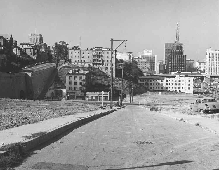
OK, the caption on this photo was
"looking southwest from 1st and Clay Street."
But isn't this the west entrance to the 3rd Street tunnel? (I recognize the 3-story building from previous pics)
Obviously many buildings have already been torn down.
But where's 2nd Street then? And I can't find Clay Street on the map I have.
Perhaps it was mislabeled.
usc digital archive |
Actually, I think it is mislabeled. I see where this is. Clay Street no longer exists, it was obliterated when Bunker Hill was regraded. I think this is actually 2nd and Clay. The 2nd Street tunnel also exists, underneath the hill; the 3rd Street tunnel is shorter than the 2nd street tunnel, the hill is irregularly shaped.
I feel fortunate in that last year on ebay, I bought a Renie Atlas of Los Angeles County that dates from 1943, so it shows Clay Street on Bunker Hill, though the tunnels aren't denoted for some reason. But comparing it with my 2001 Thomas Guide, which does denote the tunnels, I can see that the 2nd Street tunnel is longer than the 3rd Street tunnel.
Here are some photos from Tom Wetzel/
uncanny.net.
This shows Angels Flight actually crossing over Clay Street in 1943:

Here are some before and after shots.
Looking up Clay Street from 4th Street, back in the day:

The same view in a more recent photo:

Completely different now.