Quote:
|
Man. There sure is a lot of development going on. It's tough to conceptualize it honestly.
|
Winnipeg Developments
Post 3 of 3
University of Manitoba’s Master Capital Plan
Location: 65 Chancellors Circle
Developer: University of Manitoba
Architect:
Status: In development
Documents:
Project Post
Media: Building Bold: UM's Capital Plan for People, Place and Possibility
Description: The University of Manitoba has launched
Building Bold: UM's Capital Plan for People, Place and Possibility, a comprehensive 30-year master capital plan extending to 2055 that serves as a strategic roadmap for renewing, enhancing, and expanding its campuses. Unveiled in January 2026, the plan addresses major and minor capital projects, learning space modernizations, and a significant backlog of deferred maintenance (estimated at around $600 million) across approximately 3 million square feet of facilities on the Fort Garry and Bannatyne campuses, plus various satellite sites. It aligns closely with UM's MomentUM strategic plan, Truth and Reconciliation Framework, Climate Action Plan (targeting net-zero emissions by 2050, including the university's first zero-carbon building), and Strategic Research Plan. Core guiding principles include advancing academic excellence and student experience, embedding Indigenous design concepts, prioritizing sustainability and accessibility, promoting walkability with green networks and river connections, ensuring safety and belonging, preserving heritage, fostering vibrant community spaces, and practicing responsible stewardship. The plan unfolds in six five-year phases, with tailored visions for each campus. The Fort Garry campus master capital plan sets a roadmap for developing the campus core, emphasizing sustainable core development, walkability, green spaces, and integration with neighboring communities. Key components of the plan include addressing urgent priorities and future needs while supporting UM’s operational, cultural, and community goals; building for sustainability, accessibility, and walkability with green networks, high streets, river nodes, and East and South gateways; and considering impacts on neighbouring communities, including the future Southwood Circle development. Bannatyne campus focuses on coordinated renewal with minimal disruption, an iconic entrance, central quad, and blended healthcare, education, and research ecosystem.
 UM’s Master Capital Plan Major Capital Projects - Fort Garry Campus:
 Description:
 New integrated research space for soil, crops, entomology, livestock, and engineering to accelerate sustainable agriculture, field trials, and food security.

- Dafoe Library Replacement
Description: A modern, inclusive, sustainable facility to replace the aging Elizabeth Dafoe Library, creating outdoor green space and incorporating connectivity, sustainability, and Indigenous design.
 The Refinery District
 (Bishop Grandin Crossing)
Location: Bishop Grandin Boulevard and Newmarket Boulevard, Winnipeg, MB
Developer: Hopewell Development
Cost: $500+-million
Status: U/C
Media: Bishop Grandin Crossing will have it all; $500-M development will tie in with city's rapid transit corridorWinnipeg Free Press
Description: The Refinery District in Winnipeg, built on the former Manitoba Sugar Beet Factory property is a 102-acre mixed-use infill development located in the citys southwest, designed to integrate living, working, and recreational spaces. Situated between Abinojii Mikanah (formerly Bishop Grandin Boulevard) and Newmarket Boulevard, its surrounded by some of Winnipegs fastest-growing and affluent neighborhoods, like Bridgewater Forest, Whyte Ridge, Linden Ridge, and Waverley Heights. The district is a Transit-Oriented Development (TOD), with a designated station on the Southwest Rapid Transit Corridor (Plaza Station), offering a five-minute walk to rapid transit connecting to destinations like the University of Manitoba and downtown Winnipeg though it remains car-dependent for most errands. The area features a blend of residential, commercial, and industrial spaces. Residential options include luxury townhomes, modern apartments. Commercially, the district is anchored by a two-storey GoodLife Fitness (the citys largest), alongside retail, office, and flex-industrial spaces.


- Crossings 2 - The Refinery District
Location: 405, 411, 415 Ballantrae Drive
Developer: Ironclad Developments Inc.
Architect: Robert Garvey, Architecture 77 Inc.
Status: U/C
Documents: Plan Approval, September 23, 2024 | Submitted Plans | Submission
Media:
Project post
Description: Proposed are three multi-family apartment buildings of six storeys each, with a total of 208 dwelling units. This development is Phase 2 of a development project, which includes the property to the south at 425/435 Ballantrae Drive as Phase 1.
Permits: #25-111050 MU-2025-04-02,
Construct New. 405/
411 Ballantrae Permit. Construct a two 6-storey, 5,589 m² Building A and 6,183 m² Building B, 121 units multi-family wood-framed buildings with shared parkade.
#25-111192 MU-2025-04-02,
Construct New. 415 Ballantrae Permit. Construct 6-storey, 9,181 m², 87 units multi-family wood-framed building with underground parkade.
 Location: 225 Newmarket Boulevard
Developer: Porchlight Developments
Location: 225 Newmarket Boulevard
Developer: Porchlight Developments and
Marwest Management
Architect: Raymond S C Wan Architect Inc
Status: U/C
Documents: Plan ApprovalMay 30, 2022 | Submitted Plans | Submission
Media:
Project post
Description: The applicant wishes to construct, in two phases, a residential building older adults.
Phase 1 is proposed to include: 135 Assisted Living Units in a combined 4 and 6 storey building on the westerly portion of the property. 115 vehicle parking stalls including 78 underground and 37 outdoor.
Phase 2 is proposed to include: 115 independent apartment units for older adults in a combined 4 and 6 storey building on the easterly portion of the property. 84 vehicle parking stalls including 51 underground (with room for possible 73 additional stalls) and 31 outdoors.
The site plan includes a large courtyard, several pedestrian entrances and ground level routes/connections, bike parking and a wide range of landscaping throughout the site including trees and outdoor seating. The building includes, shared and private dining options, a large glazed entrance off the courtyard, multiple lounges, a theatre, workshop and dog washing station and Individual entrances, balconies and ground level outdoor patios.
Permits: #25-149387 MU-2025-06-09,
Construct New. Optional Professional Certification Program Permit. Six storeys with a below grade parking garage and a building area (footprint) of approximately 5,580 m². The building is not considered to be a high building. THE WILLISTON REFINERY LTD. - Construct a six-storey,209,430 ft² new apartment building (Phase I) with 138 units and an underground parkade. An additional 112 units will be constructed in Phase II. The WRRF will function as a Group C (Residential) major occupancy with subsidiary Group D (Business and Personal Services), Group A, Division 2 (Assembly) and Group F, Division 3 (Low-Hazard, Industrial) occupancies.

- 250 Newmarket Boulevard - The Refinery District
Location: 250 Newmarket Boulevard
Developer: Hopewell (Bishop Grandin) Development Inc.
Architect: Raymond S C Wan Architect Inc
Status: In Development
Documents: Plan Approval, June 24, 2025 | Submitted Plans
Media:
Description: The applicant proposes a single-storey commercial building with four commercial rental units (CRUs), each ranging from 1,374 to 1,500 square feet. The development includes a 548-square-foot outdoor patio and uses concrete unit paving as the patio surfacing material, the building will be constructed using brick veneer and EIFS materials. Additionally, the proposal incorporates four bicycle parking spaces and a landscaping plan featuring ten new trees, 111 new shrubs, and 13 new perennials and grasses.
Permits:
 Naawi-Oodena - Kapyong Barracks Redevelopment
Location: Route 90/Grant Avenue, Winnipeg, MB
Developer: Treaty One Development Corporation
Naawi-Oodena - Kapyong Barracks Redevelopment
Location: Route 90/Grant Avenue, Winnipeg, MB
Developer: Treaty One Development Corporation &
Canada Lands Company Limited
Architects (Master plan):
Scatliff+Miller+Murray
Status: Phased development -
U/C
Media: Everything is on track and going quite well’: Naawi-Oodena takes shape–
Winnipeg Free Press
Documents:Project Thread: Kapyong Barracks Discussion
Description: Naawi-Oodena, meaning "centre of the heart and community" in Anishinaabe, is Canada's largest urban reserve, located in southwest Winnipeg, on the former Kapyong Barracks site. Spanning 160 acres near the Tuxedo and River Heights neighborhoods, it is a joint project led by seven Treaty One First Nations alongside the Canada Lands Company. The site, once a military base decommissioned in 2004, was repatriated to Treaty One Nations in 2022 after a nearly two-decade legal battle over treaty land entitlement claims. The development, managed by the Treaty One Development Corporation (T1DC) for 68% of the land and Canada Lands Company for the remaining 32%, aims to create a vibrant mixed-use community. The master plan, released in 2021, includes 2,300 to 3,000 residential units, 915,000 to 1.2 million square feet of commercial space (retail, office, and institutional), and areas for cultural, educational, recreational, and community purposes. It emphasizes Indigenous design, incorporating traditional elements like Anishinaabe-inspired patterns, native plants, and cultural spaces, while fostering economic growth and reconciliation. The project, expected to take 10-15 years and generate over $2 billion in economic impact, is designed to integrate with surrounding neighborhoods, offering housing, retail, and services for both Indigenous and non-Indigenous residents. The City of Winnipeg provides municipal services like policing and fire protection under the 2022 Gaawijijigemangit Agreement, with Treaty One collecting taxes mirroring city rates, remitting 65% to the city and retaining 35% for community development. The city of Winnipeg does not have jurisdiction to approve or regulate development on the treaty 1 lands that make up approximately 108 acres of the site, the 51 acres to be developed by the Canada Lands Company is subject to the city of Winnipeg bylaw regulations.


 • Video Link
- Naawi-Oodena T1N- Phase 1 (Block A)
Status: U/C
Media: Naawi-Oodena: A vision for the future of Winnipeg-Winnipeg Regional Real Estate News | Good Neighbors, Better Development-Manitoba Inc.
Description: Construction on Block A began in April 2024, with the entire parcel expected to be completed by 2028. This phase is part of a broader master plan for Naawi-Oodena, aiming to create a vibrant mixed-use community on the former Kapyong Barracks site, led by the Treaty One Development Corporation. Phase One of Block A in the Naawi-Oodena development, located at the northeast corner of Kenaston Boulevard and Taylor Avenue, consists of the following key components:
- Oodena Gas Bar, 1871 Taylor Ave, A 24-hour gas and convenience station (Completed June 2025).
Media: Naawi Oodena gets first business–CTV Winnipeg YouTube

- The Treaty One Development Corporation Business Park, Planned as a commercial mixed-use zone with up to 130,000 square feet of commercial space, including a 95,000 square foot commercial centre. It supports retail, services, and other business uses, emphasizing Indigenous-led economic development.


 Location: Naawi-Oodena
Developer: Treaty One Development Corporation
Architects: Number TEN Architectural Group
Location: Naawi-Oodena
Developer: Treaty One Development Corporation
Architects: Number TEN Architectural Group [Building] |
HTFC Planning & Design [Courtyard]
Status: U/C
Media:
Documents:
Description: 260 unit apartment complex

- Naawi-Oodena - Canada Lands Company - Phase 1
Developer: Canada Lands Company Limited
Status: Subdivision and Rezoning application
Media: Naawi-Oodena takes another step toward development of 300-plus homes–
CBC News Manitoba
Documents:Description: As part of the first phase of the Naawi-Oodena redevelopment on the Canada Lands Company portion of the former Kapyong Barracks site in southwest Winnipeg, the applicant has proposed subdividing the property to establish 32 new lots, one dedicated public reserve, and new public streets and lanes. This initiative supports the creation of a vibrant, mixed-use community through rezoning the land from its current “RR5” Rural Residential designation to a Planned Development Overlay (PDO), which will provide a tailored regulatory framework to guide future building and land use. The subdivided lots comprise 27 “R2” Residential Two-Family parcels suitable for duplexes or similar low-density housing, four “RMF-M” Residential Multi-Family (Medium) lots intended for mid-rise apartments or townhouse developments, one “CMU” Commercial Mixed Use lot to accommodate retail, office, or service-oriented businesses, and one “PR1” Parks and Recreation (Neighbourhood) lot designated as a public reserve to enhance community green space. This phase, for which municipal rezoning and subdivision approvals were granted in June 2025, lays the groundwork for initial residential and supporting development, including ties to federal efforts like Build Canada Homes to deliver approximately 320 affordable units on a prioritized parcel using modern construction methods. Subsequent phases of the broader Naawi-Oodena project on the Canada Lands side will involve additional subdivision applications, rezoning requests, and potential PDO amendments to realize the full vision of up to around 2,000 homes across the entire 160-acre site, alongside substantial commercial, cultural, and recreational elements in partnership with Treaty One First Nations.
 Water Tower District
Location: St. Boniface, Winnipeg, MB
Developer: Olexa Developments
Water Tower District
Location: St. Boniface, Winnipeg, MB
Developer: Olexa Developments |
Shindico Realty Inc.
Status: In development
- Construction of essential infrastructure, including roads, water, and sewer systems, began in 2023, with internal roads expected to be completed by 2025.
Media: SHINDICO on the horizon: The Water Tower District-
Winnipeg Regional Real Estate News
Project Thread: St. Boniface | Water Tower District
Documents:
Description: The Water Tower District is a 165-acre mixed-use development in Winnipeg’s St. Boniface neighbourhood, led by Calgary-based Olexa Developments and Winnipeg’s Shindico Realty. Located on a former brownfield site, previously home to meat-packing plants, the project aims to revitalize one of the city’s oldest areas into a vibrant, transit-oriented community. Approximately 70 acres are designated for light-to-medium industrial use, offering nearly one million square feet of shovel-ready employment space. Another 25 acres are dedicated to multi-family residential development, providing over 1,200 rental units. Commercial and retail spaces occupy 21 acres, fostering local business and services, while 22 acres are reserved for parks and green spaces, enhancing livability and recreation. This thoughtful land use plan supports the project’s vision of a sustainable, 15-minute city, with completion expected by 2033. The site includes the historic St. Boniface Water Tower, built in 1936 and enlarged in 1945, though decommissioned in the 1970s. The tower now houses communication infrastructure for the city’s water system.

 Southwood Circle (University of Manitoba development)
Location: 230 University Crescent-North Campus Lands
Developer:
Southwood Circle (University of Manitoba development)
Location: 230 University Crescent-North Campus Lands
Developer: UM Properties
Architects (Master plan):
DIALOG | Scatliff+Miller+Murray
Status: In development
- Recent activities include site servicing, road construction, and riverbank stabilization, with some active transportation routes closed for safety during construction.
Documents:Media: Project Thread: UofM | Southwood Circle
Description: Southwood Circle is a major mixed-use infill development project in south Winnipeg, located on approximately 110.67 acres of former Southwood Golf and Country Club land, adjacent to the University of Manitoba’s Fort Garry campus. It aims to transform the area into a sustainable, walkable urban community, often described as Manitoba’s first “UniverCity” and the largest infill project in Winnipeg’s history. The $6-billion development, managed by UM Properties (an arm’s-length entity of the University of Manitoba), will be built in four phases over 20 years, with construction starting in 2024 and will include over 11,000 residential units (apartments and townhouses) to house up to 20,000 people, and 300,000 square feet of commercial retail space. The development emphasizes on sustainability and renewable energy, LEED Gold buildings, geothermal energy, carbon capture, on-site recycling, composting, and EV sharing. Over 5,000 mature trees (some 300 years old) will be preserved, with two trees planted for every one removed, and 21 acres of parkland, including 9 acres of Red River waterfront, will be developed. A Living Lab Research Consortium will involve developers, faculty, and students in data-driven research to enhance sustainability and community wellness. Southwood Circle aims to integrate the university with Winnipeg’s urban fabric and connect to downtown via rapid transit. With a projected daily campus population of 60,000, it’s set to become Manitoba’s second-largest urban centre after Winnipeg.
Permits: #24-264287 DP-2025-02-04,
Permit. Development permit for an underground site servicing/riverbank stabilization works.

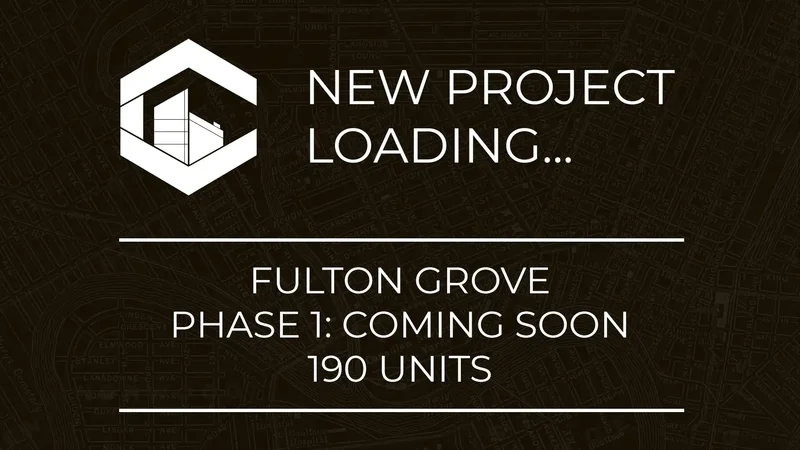
 Fulton Grove Development
Location: Fulton Grove (Parker Lands)
Developer:
Fulton Grove Development
Location: Fulton Grove (Parker Lands)
Developer: Gem Equities
Status: In development
Documents:Media: Parker Lands project moving forward–Winnipeg Free Press
Project Thread: Fulton Grove Development
Description: Fulton Grove is a significant transit-oriented residential development in Winnipeg’s Parker Lands, a 19-hectare site in Fort Garry, led by Gem Equities under developer Andrew Marquess. The project aims to create a dense, walkable, mixed-use neighborhood with 1,918 housing units, including 23 mid-rise apartment towers, townhouses, duplexes, triplexes, and single-family homes. Designed to align with the city’s Our Winnipeg plan, it emphasizes sustainability and affordability, featuring geothermal heating and proximity to the Southwest Transitway. The development promotes a 15-minute city model, offering condos and rentals alongside public green spaces. The project has faced a complex history since its inception in 2009, marked by a controversial land swap, protests over forest clearing in 2017, and prolonged legal disputes. A 2018 court ruling mandated public hearings, and while a $5-million judgment was awarded to Marquess in 2023 for city delays, this was overturned by Manitoba’s Court of Appeal in 2025. After 11 years of challenges, Winnipeg’s city council unanimously approved rezoning in April 2024, paving the way for construction to begin soon. Fulton Grove represents a transformative step for Winnipeg, addressing housing shortages, enhancing urban connectivity, and advancing sustainable development.


 Location: Parker lands
Developer: Carrington Real Estate
Architect:
Location: Parker lands
Developer: Carrington Real Estate
Architect: -
Status: In Development
Documents: -
Media: -
Description: Fulton Grove Phase 1 features a luxury apartment complex with a total of 190 units. The estimated completion date is Fall 2027.
 Location: Parker lands
Developer: Carrington Real Estate
Architect:
Location: Parker lands
Developer: Carrington Real Estate
Architect: -
Status: In Development
Documents: -
Media: -
Description: Fulton Grove Phase 2 features a luxury apartment complex with a total of 215 units. The estimated completion date is Fall 2028.
 Polo Park (mall parking lot redevelopment)
Location: 1485 Portage Ave, Winnipeg, MB
Developer(s): Shindico
Polo Park (mall parking lot redevelopment)
Location: 1485 Portage Ave, Winnipeg, MB
Developer(s): Shindico &
Cadillac Fairview Corporation Limited.
Status: In development
Media: Project Thread: Polo Park Expansion
Renderings
Description: Cadillac Fairview and Shindico are spearheading a $1 billion redevelopment of the 84-acre Polo Park Mall, the largest shopping centre in Manitoba, including the former Canad Inns Stadium site, to create a mixed-use, pedestrian-friendly community. The Master Plan vision includes up to 4,000 residential units in high-rise and mid-rise buildings, new retail zones like The Commons and The Hub, office spaces, and potential assisted living facilities, alongside parks, cycling paths, and improved transit connections. Surface parking will be replaced with underground or multi-level parkades, and infrastructure upgrades will address traffic concerns. The decade-long project, with the first phase targeting the stadium lands, aims to house 5,000 people and revitalize west Winnipeg, pending city council approval.
Master Plan Vision:
 Stadium Lands:
 The Market:
 The Hub:
 The Commons:
 CentrePlan 2050
Location:
CentrePlan 2050
Location: Downtown
Developer: City Of Winnipeg
Status: On
September 26, 2024 Council adopted CentrePlan 2050 as a secondary plan by-law for Downtown Winnipeg.
Documents: CentrePlan 2050 By-law 72/2024
Media: CentrePlan 2050 aims to revitalize downtown Winnipeg
Description: CentrePlan 2050 is a secondary plan by-law that sets out five strategic moves to create a resilient and thriving downtown Winnipeg:
- Create great urban neighbourhoods
- Re-envision streets to foster urban life
- Grow a greener Downtown
- Create a lively Downtown
- Improve Downtown governance and implementation
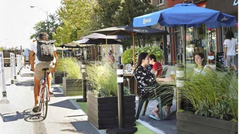
 Location: Graham Avenue
Developer:
Location: Graham Avenue
Developer: City Of Winnipeg
Status: 2025 start
Documents: CentrePlan 2050 - May 2024 | CentrePlan 2050 - Re-imagining Graham Avenue
Media:Project Post
Description: The City wants to create a signature street in Downtown. A place to meet-up on a patio, attend a market, gather for events, read a book in the shade, or walk a dog. In June 2025, bus routes will begin moving off Graham Avenue as planned in the Winnipeg Transit Master Plan. This gives Winnipeg an incredible opportunity to re-imagine how we use Graham Avenue.


 Portage & Main Revitalization
Location: Portage & Main
Developer:
Portage & Main Revitalization
Location: Portage & Main
Developer: City Of Winnipeg
Status: Phase 1 - open to pedestrians completed June 2025
Thread:
Winnipeg | Portage and Main
Documents:Media:Description: Winnipeg’s iconic Portage & Main intersection is undergoing a transformative revitalization, with
plans to restore pedestrian street-level crossing by July 1, 2025. The project, spurred by the need to replace the aging waterproofing membrane of the underground concourse, aims to enhance accessibility and revitalize the public space at this historic civic landmark.
Since 1979, barriers have blocked pedestrian crossings at street level, funneling foot traffic through the underground concourse. The city now plans to decommission this concourse, with ongoing studies assessing its condition, closure costs, and potential traffic impacts. Public engagement in 2023 has shaped the project’s vision, prioritizing safety and inclusivity for the intersection.
The 2024-2025 construction project is the first step in revitalizing Portage & Main, in the future, a study will be commissioned to determine how best to decommission and close the concourse and will focus on implementing the
longer-term recommended design vision. Additional streetscaping design work will be included in the upcoming Rapid Transit (Downtown Corridors) Preliminary Design Study which is expected to begin in 2025 and will integrate Winnipeg Transit infrastructure into the final design of the intersection. With significant infrastructure investment, the city aims to reimagine Portage & Main as a vibrant, pedestrian-friendly hub, reinforcing its status as a cultural cornerstone of Winnipeg.


 • Video Link
Winnipeg Transit Master Plan
Description:
• Video Link
Winnipeg Transit Master Plan
Description: The Winnipeg Transit Master Plan, adopted on April 29, 2021, outlines a long-term strategy to transform public transit in Winnipeg by introducing a new, resilient transit network designed to adapt to the city's growth. The plan emphasizes a frequent transit network, significantly increasing the number of households within a short walk of frequent transit services. At its core is an expanded Rapid Transit system, featuring six corridors forming three lines, with downtown infrastructure, including an elevated transitway and Union Station as a central mobility hub, as the top priority. Additionally, the plan enhances Winnipeg Transit Plus, integrating it with conventional and On-Request services to create a more seamless, accessible, and interconnected transit network.
Media:Documents:Union Station | Central hub of the rapid network:
 • Video LinkLocation: Oak Point Highway and Selkirk Avenue
Developer:
• Video LinkLocation: Oak Point Highway and Selkirk Avenue
Developer: City Of Winnipeg
Consultants: Dillon Consulting
Status: U/C
Documents:Media:Description: Winnipeg Transit is set to build a new, state-of-the-art $200M bus garage in the Point Douglas Ward at the intersection of Selkirk Avenue and Oak Point Highway to replace the outdated North Garage at 1520 Main St., which is too small to accommodate future growth. The new facility, designed to house approximately 250 buses at it's full build out, including 60-foot articulated buses, buses with bike racks, roof-mounted air conditioners, and zero-emission buses, will feature an energy-efficient storage, service, and maintenance facility. The project, funded through the Public Transit Infrastructure Stream’s Investing in Canada Infrastructure Program, includes contributions of up to $73.0 million from the Government of Canada, $60.8 million from the Province of Manitoba, and $48.7 million from the City of Winnipeg. The design phase is currently underway and expected to be completed by the end of 2024, with construction slated to begin in 2025 and finish by 2027, ensuring Winnipeg Transit can continue meeting riders' needs with modern, sustainable infrastructure.

 • Video Link
Location:
• Video Link
Location: Sutherland Avenue through Point Douglas, across a new Louise Bridge, and along Nairn and Regent avenues
Developer: City Of Winnipeg
Status: In Development
Documents:Media:Description: The Eastern Corridor Study, initiated in 2017 following the 2011 Transportation Master Plan's recommendation, aims to determine the optimal route, design, and infrastructure for rapid transit between Downtown and eastern Winnipeg, while also exploring replacement options for the Louise Bridge. With the route now approved to utilize a new Louise Bridge, the study focuses on developing new rapid transit infrastructure and replacing the bridge and surrounding roadway. The study does not cover transit service details, such as lines and frequencies, which are outlined in the Winnipeg Transit Master Plan adopted in 2021, designating the Eastern Corridor’s service as the Rose Line. The corridor is divided into three priority segments: Stage 1 (Harkness Station to Main Street CP Railway underpass, shared with Blue and Orange Lines), Stage 2 (Main Street CP Railway underpass to Watt Street), and Stage 3 (Watt Street to Plessis Road). Stage 1 is deferred to the upcoming Rapid Transit Downtown Corridor study, Stage 3 to a future Northeast Corridor study, and Stage 2 is the current focus of engagement. Details on the preferred alignment and decision factors are provided in an appendix to the Winnipeg Transit Master Plan.


 Transportation Master Plan (Transportation 2050)
Description:
Transportation Master Plan (Transportation 2050)
Description: Transportation 2050 is a comprehensive plan to transform Winnipeg’s transportation system into a sustainable, accessible, and safe network by 2050, emphasizing walking, cycling, transit, and ridesharing while acknowledging the continued role of cars. The plan aims to achieve four key targets: supporting economic prosperity through efficient goods movement, achieving a 50% mode share for sustainable transportation, reducing fatal and serious injury collisions by 20% by 2026, and ensuring an accessible and equitable transportation system. It outlines seven key directions, including integrating land use with transportation, prioritizing infrastructure maintenance, and enhancing active transportation and transit reliability. The plan supports complete communities, improves pedestrian and cycling networks, investigates future light rail transit, and addresses goods movement through a dedicated study, promoting efficient truck routes, intermodal connectivity, and low-carbon freight options. By fostering regional collaboration and strategic investments, Transportation 2050 seeks to balance economic growth, safety, and sustainability while enhancing mobility for all Winnipeggers.
Documents:Media: Location: Arlington Bridge
Developer:
Location: Arlington Bridge
Developer: City Of Winnipeg
Status: In Development
Documents:Media:Description: The century-old Arlington Bridge, a vital link in Winnipeg’s infrastructure, is nearing the end of its lifespan and will be replaced with a modern design to meet the city’s growing needs. Closed since late 2023, the bridge’s replacement project has taken a significant step forward with the completion of its preliminary design and a $22 million budget amendment approved by the city council’s executive policy committee for demolition and redesign. The new bridge, spanning from McDermot Avenue to Selkirk Avenue, will address the limitations of the existing structure, which struggles to accommodate modern traffic demands and accessibility standards. With Winnipeg’s population projected to grow by 200,000 over the next 25 years, the redesigned bridge aims to improve connectivity for commuters, transit users, cyclists, and pedestrians while enhancing emergency access and traffic flow. Key improvements include gentler inclines and wider sidewalks for easier walking and cycling, dedicated pedestrian and bike paths, and support for transit buses, which are currently rerouted due to the bridge’s restrictions. The new design will also accommodate commercial trucks and add an extra traffic lane to reduce congestion. Emergency vehicles, previously unable to cross, will gain direct access, improving response times. Beyond functionality, the project promises local enhancements, including connections to the city’s cycling network, upgraded roads and intersections, and public art to beautify the area. Surplus land near the bridge may also open opportunities for future development. The City of Winnipeg is collaborating with technical experts and the public to finalize the design, with a map of proposed improvements now available. As the city prepares for a growing population, the new Arlington Bridge is poised to become a cornerstone of improved urban mobility and community connection.
 • Video Link
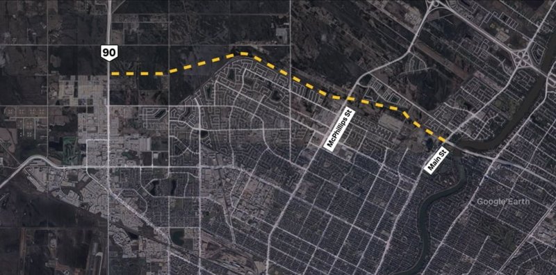
Location: Route 90 between Taylor Avenue and the St. James Bridges.
Developer:
• Video Link
Location: Route 90 between Taylor Avenue and the St. James Bridges.
Developer: City Of Winnipeg
Status: In Development
- On June 27, 2024 Council approved the preliminary design. The project was referred to the 2025 Investment Planning process. The City will move forward with an independent value for money assessment. The assessment will evaluate the business case and alternative project delivery methods. Detailed design and funding is required before construction begins.
Documents:Media:Description: The 2018 Route 90 Improvements Study builds on the 2012 Transportation Planning Study by developing a $737-million preliminary design for Route 90, incorporating three travel lanes in each direction, modifications to the St. James bridges, ramp structures, and the Portage Avenue and Academy Road interchanges. The design prioritizes enhanced traffic flow, safety, and accessibility for pedestrians, cyclists, and transit users while maintaining two lanes of traffic in both directions during construction. Key improvements include roadway enhancements to reduce congestion, safety measures to minimize collisions and ensure safe crossings, infrastructure to support walking and cycling, and place-making features like landscaping, green spaces, and public art. These upgrades aim to address current and future traffic demands, accommodate new developments, and enhance the surrounding communities.
 • Video Link
Location: Main Street to Brookside Boulevard
Developer:
• Video Link
Location: Main Street to Brookside Boulevard
Developer: City Of Winnipeg
Status: In Development
- June, 2019 - An administrative report was presented to council at the June 20, 2019 meeting, with a recommendation that the Chief Peguis Trail Extension West project be considered and prioritized amongst other major unfunded capital projects through development of a City Infrastructure Plan. This recommendation was accepted by council. The project timing projection has been updated as part of the Transportation Master Plan review, and presented as part of the final document of that study.
Documents:Media:Description: The Chief Peguis Trail (CPT) Extension West, approved in 2012 as an amendment to the Transportation Master Plan, involves constructing a four-lane divided roadway from Main Street to Brookside Boulevard in Winnipeg, spanning approximately 10 kilometers. The project includes overpasses at Main Street and McPhillips Street, four intersections, three pedestrian and cycling overpasses, and improvements to the Kildonan Settlers Bridge to enhance intersection and pathway connectivity. The estimated cost for the full extension was $486.6 million in 2019 and is now $755 in 2025, with a phased approach costing $262.3 million for the Main Street to McPhillips Street segment, and the remaining section to Brookside Boulevard to be completed later based on need. These 2020-based estimates require a 3% annual inflation adjustment if delayed. Traffic projections suggest the Main Street to McPhillips segment may not be needed until after 2031, with further analysis pending in an upcoming Transportation Master Plan review. A Functional Design Study informed the project’s scope, aiming to support economic and residential development by as many as 15,000 new homes, reduce neighborhood traffic, and enhance transit, walking, and cycling. A cost-benefit analysis in the report estimates the net economic and social benefits from building the extension to be $98 million over 50 years. A Preliminary Design Study is underway to finalize the design, ensuring it accommodates traffic flow, connects neighborhoods, includes pedestrian and cycling infrastructure, supports public art, and minimizes environmental impact. The project’s prioritization among other unfunded capital projects will be addressed through a City Infrastructure Plan.
 • Video Link
Location: Marion Street between St. Mary’s Road and Lagimodiere
Developer:
• Video Link
Location: Marion Street between St. Mary’s Road and Lagimodiere
Developer: City Of Winnipeg
Status: In Development
- The recommendations will be considered by Standing Policy Committee on Public Works on July 3, 2025.
Documents:Media:Description: In 2014, the City of Winnipeg conducted the Marion Grade Separation and Widening Study to enhance traffic flow and capacity along Marion Street from its east limit to Goulet Street, concluding in 2016 with five proposed options, including a costly and intrusive interchange at the CPR Emerson line and Archibald Street, which was ultimately shelved due to community concerns and excessive costs. In response to the narrow focus of the initial study, the City launched the Moving on Marion Street project in 2019, starting with Phase 1 community pre-engagement to refine objectives and engagement methods. The redefined project now addresses safety, traffic flow, and livability, expanding its scope to cover three interrelated neighbourhood areas: the West Segment (Marion-Goulet couplet, a mixed-use main street, and a transitional zone from Youville Street to Archibald), the East Segment (a manufacturing and industrial corridor from Lagimodière to Archibald), and the broader Marion corridor as a vital city route. The project incorporates stakeholder input, public feedback, and statistical data to develop cost-effective solutions tailored to the diverse needs of the community.
 Location: Assiniboine River crossing, McFadyen Park and Fort Rouge Park, Winnipeg, MB
Developer:
Location: Assiniboine River crossing, McFadyen Park and Fort Rouge Park, Winnipeg, MB
Developer: City of Winnipeg
Architect: TBD
Contractor: TBD
Size: TBD
Cost: Unfunded
Status: design Stage
Media: 3 designs pitched for new pedestrian bridge over Assiniboine River
Renderings
Description: A preliminary design for a new pedestrian and cycling bridge over the Assiniboine River will be developed to connect Osborne Village to Downtown via McFadyen Park on the north side of the river and Fort Rouge Park on the south side of the river. Considerations for this project include pedestrian and cycling connectivity throughout Osborne Village to Osborne Rapid Transit Station, Norwood Bridge, bike lanes on Nassau Street, and the riverwalk, upgrades to both McFadyen Park and Fort Rouge Park, crime prevention through environmental design (CPTED), and riverbank stabilization.
Bridge Option 2 of 3: Cable-Stayed Bridge:
Landmark double curved bridge:

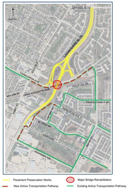
 Lagimodiere Twin Overpasses Rehabilitation Project
Location: Lagimodiere Overpass
Developer:
Lagimodiere Twin Overpasses Rehabilitation Project
Location: Lagimodiere Overpass
Developer: City Of Winnipeg
Status: U/C
Documents:Media:Description: The City of Winnipeg has launched a major rehabilitation project on the Lagimodiere Twin Overpass bridges at Concordia Avenue, where Lagimodiere Boulevard crosses over Concordia Avenue and the CPKC rail line. With a budget of approximately $51 million, the initiative aims to extend the bridges' service life by an additional 50 years while enhancing overall infrastructure safety and accessibility in this critical transportation corridor. The work encompasses bridge repairs, road and ramp rehabilitation, improved drainage, and pavement restoration along Lagimodiere Boulevard from Almey Avenue to Grassie Boulevard, as well as along Concordia Avenue from Molson Street to Peguis Street. A key enhancement includes new multi-use pathways for pedestrians and cyclists: one along Concordia Avenue from Molson Street to Panet Street, and another on the east side of Lagimodiere Boulevard connecting Reenders Drive to Ravelston Avenue West, bolstering the city's active transportation network. Construction spans 2026 and 2027, with phased work to minimize disruption. In 2026 (Phase 1, focusing on the southbound bridge and lanes, expected through late October or November), traffic shifts to the northbound bridge, reducing Lagimodiere Boulevard to one lane per direction. In 2027 (Phase 2), the process reverses to the northbound bridge. Interchange ramps to/from Concordia Avenue may close for 6-8 weeks at times for pavement repairs. Transit services remain unaffected, and the sidewalk along Concordia Avenue stays open for pedestrians.
 CentrePort Canada
Location: CentrePort Canada Way
Developer:
CentrePort Canada
Location: CentrePort Canada Way
Developer: CentrePort Canada
Status: U/C
Documents: Agreement for Services with Winnipeg Airports Authority – January 20, 2026
Media:Thread: Winnipeg | CentrePort Canada
Description: CentrePort Canada stands as North America's largest trimodal inland port and Foreign Trade Zone, encompassing approximately 20,000 acres of prime, affordable industrial land in northwest Winnipeg and the Rural Municipality of Rosser, Manitoba. Strategically positioned adjacent to
Winnipeg James Armstrong Richardson International Airport, it offers seamless integration of rail (via three Class I railways: CN, CPKC, and BNSF), air cargo (with 24/7 global operations handling thousands of freighter flights annually), and trucking networks, providing efficient access to North American markets and beyond. Home to over 1,000 tenants—including major players like Boeing, StandardAero, FedEx, MacDon, and Paterson GlobalFoods—CentrePort has developed more than 2,300 acres since its inception around 2009, driving significant economic growth in sectors such as aerospace, agribusiness, advanced manufacturing, logistics, and life sciences. As of early 2026, the inland port is experiencing robust momentum amid global supply chain shifts. Key 2026 developments include the near-completion of major water and wastewater infrastructure in CentrePort South by mid-year, unlocking 1,800 acres for development (including 1,100 acres of industrial land and a 500-acre mixed-use residential community). The Winnipeg Airports Authority's new multi-tenant air cargo facility is set to become operational by summer, while ongoing expansions, land sales, and private investments continue at a record pace. Recent initiatives, such as the January 2026 "Ports Manitoba Project"—a landmark Memorandum of Understanding uniting CentrePort with the Port of Churchill, Winnipeg Airports Authority, and federal/provincial partners—aim to enhance inland, air, and Arctic trade corridors, diversifying routes and attracting further investment. With vast remaining land, supportive government funding (including a recent provincial investment), skilled workforce programs, and its central location offering low costs and FTZ benefits, CentrePort Canada holds strong future growth potential. It is poised to solidify Manitoba's role as a key North American logistics and supply-chain hub, fueling job creation, business expansion, and economic diversification in the years ahead.
 • Video Link