HomeDiagramsDatabaseMapsForum About
     

Go Back   SkyscraperPage Forum > Discussion Forums > City Discussions


Reply

 
Thread Tools Display Modes
     
     
  #21  
Old Posted Aug 14, 2018, 10:05 PM
austlar1 austlar1 is offline
Registered User
 
Join Date: May 2007
Location: Austin
Posts: 3,431
Here's my Austin fantasy. I'd love to see a light rail (sorry) subway tunnel from the base of South Congress Ave just south of Town Lake that ran north under Town Lake and through downtown Austin under Congress Ave. This tunnel would capture light rail from both South Congress and Riverside Drive/Airport light rail lines The tunnel would jog to the left near the Capitol and run underneath Guadalupe all the way past the UT campus area. The tunnel would emerge above ground somewhere in the Highland Mall area where trains could utilize the existing light rail line to Leander and planned light rail expansions to other points north and east. This tunnel would solve the downtown and campus area bottlenecks that basically make above-ground light rail impossible through those areas. The tunnel would be five or six miles in length and cost way more than local taxpayers are willing to spend. I believe it would be money well spent and would totally transform this city.
Reply With Quote
     
     
  #22  
Old Posted Aug 14, 2018, 10:08 PM
dc_denizen's Avatar
dc_denizen dc_denizen is offline
Selfie-stick vendor
 
Join Date: Oct 2005
Location: New York Suburbs
Posts: 10,999
For dc, Bethesda to Tyson’s corner

For New York, extend metro north to downtown and brooklyn
__________________
Joined the bus on the 33rd seat
By the doo-doo room with the reek replete
Reply With Quote
     
     
  #23  
Old Posted Aug 14, 2018, 10:26 PM
The Chemist's Avatar
The Chemist The Chemist is offline
恭喜发财!
 
Join Date: Aug 2001
Location: 中国上海/Shanghai
Posts: 8,883
Considering that the line I'd most want built in Shanghai, the one that goes right by my house, is under construction right now, I don't think I'd need to add any lines.

One of the great things about living in Shanghai is how seriously they take subway construction here - the Shanghai Metro has grown from 5 lines when I first moved here in 2007 to 15 operational lines today (16 if you include the Pujiang people mover line) with extensions to 3 lines and 3 new lines under construction. There's no need for fantasy when the reality is just as good.
__________________
"Nothing is too wonderful to be true, if it be consistent with the laws of nature." - Michael Faraday (1791-1867)
Reply With Quote
     
     
  #24  
Old Posted Aug 14, 2018, 11:18 PM
SkahHigh's Avatar
SkahHigh SkahHigh is offline
More transit please
 
Join Date: Jul 2013
Location: Montreal
Posts: 3,794


Two east-west transit-starved boroughs with a combined population of 130,000 getting Metro service between each other (not the main objective though) and dense areas of Rosemont finally being close to a Metro.
Reply With Quote
     
     
  #25  
Old Posted Aug 14, 2018, 11:23 PM
skyscraper skyscraper is offline
BANNED
 
Join Date: Feb 2006
Posts: 1,374
Quote:
Originally Posted by Londonee View Post

Source: philadelphiastudies.org

^^^This is a modern representation of the original 1913 Plan for Philadelphia. Obviously only a few of those lines were built in actuality.

But, if I could choose (1) one line to build, it would probably be something similar to the Center City Loop pictured above - that only got about 50% finished. I'd probably have the Western side of the Loop extend over to 20th street as a Rittenhouse Square portal, Locust to the South (as it is now), up 8th street (as it does now), and then the northern side along Vine/Race as pictured. Effectively connecting the original 4 Squares.
Always loved this map. But as for which line to build, the correct answer is the Roosevelt boulevard line, which is the 5 line on this map. It would serve a population of 400,000 people. No brainer. Should have built it 100 years ago.
Reply With Quote
     
     
  #26  
Old Posted Aug 14, 2018, 11:46 PM
GlassCity's Avatar
GlassCity GlassCity is offline
Rational urbanist
 
Join Date: Aug 2012
Location: Metro Vancouver
Posts: 5,267
There are a number of proposals in Vancouver currently, with some more immediate than others so it's kind of a complicated question. But here's what I've got.

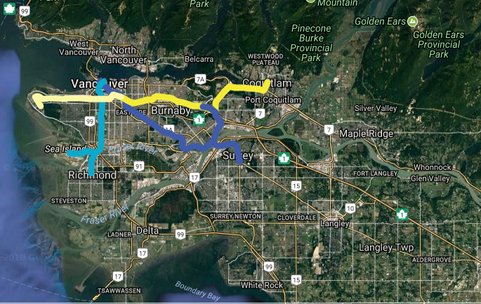
So this is what the current SkyTrain (grade-separated light metro) system looks like: (the brown line is a frequent high-capacity passenger ferry. It goes in and out of my future pics, don't worry too much about it - or about the stations that I took out after!)

Existing by Glass_City, on Flickr

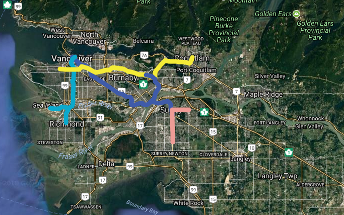
And if I'm just showing the one line I want to be built from there, it's this one. That corridor, Broadway, is one of the busiest bus corridors in North America right now, with over 100,000 passengers a day. They go to major employers along the middle of the line, and the University of British Columbia at the western end. It would help tons of people, and the corridor just needs capacity relief; it can't take much more.

Want 3 by Glass_City, on Flickr

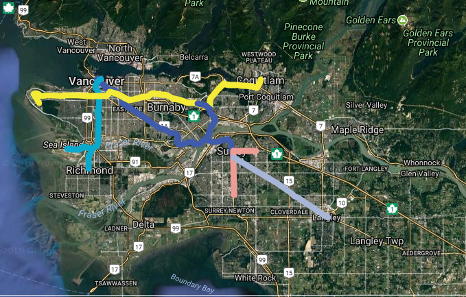
Now the current immediate proposal includes a Broadway line going halfway to UBC, so just serving the office area, as well as an LRT line in Surrey:

Immediate Proposal by Glass_City, on Flickr

In which case my priority would still be to extend the line to UBC.

The more longterm proposals also include finishing the line to UBC, and building an LRT line from Surrey to Langley:

Longterm Proposal by Glass_City, on Flickr

In this case, I think the number one priority would be a line on the North Shore. There are some good urban neighbourhoods there, with a good amount of existing density and transit ridership, and traffic there is absolutely brutal. Because connections downtown from the western end would be long and circuitous, I connect it on the east. Plus, downtown is already served by a frequent high capacity passenger ferry, that I put in brown:
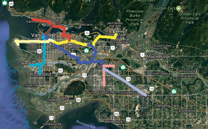
Want 4 by Glass_City, on Flickr
Reply With Quote
     
     
  #27  
Old Posted Aug 15, 2018, 3:08 AM
Jasoncw's Avatar
Jasoncw Jasoncw is offline
Registered User
 
Join Date: Mar 2007
Location: Detroit, Michigan
Posts: 402
For Detroit, downtown Detroit to West Dearborn.

Specifically, a People Mover extension starting at Joe Louis Arena, following W. Jefferson a little before following the rail ROW behind Michigan Central station. It would pass along the north edge of SW Detroit, before moving to Michigan Avenue near Livernois. After this it would go west until switching to Ford Road, where it would continue through Dearborn, wiggling through the Fairlane area, before ending at Ford HQ/museum.

This route connects high employment density census tracts (downtown Detroit and Fairlane), most of the highest population density census tracts in the region, includes major tourist destinations, shopping, over 15,000 college students, and massive TOD opportunities. It could be extended to the airport, has good park and ride positioning for western Wayne County, and would be a strong backbone for North-South running buses along the route.
Reply With Quote
     
     
  #28  
Old Posted Aug 15, 2018, 3:36 AM
ardecila's Avatar
ardecila ardecila is offline
TL;DR
 
Join Date: Jun 2006
Location: the city o'wind
Posts: 16,368
Quote:
Originally Posted by 10023 View Post
I don’t think anyone would build Chicago’s Loop now. It’s a huge bottleneck

And the whole design of Chicago’s mass transit system is too centralized for a much larger, modern metropolis - to get from Lakeview to Logan Square by train, you have to go all the way into the Loop and back out on the Blue Line.

The best systems are ones like Tokyo and Paris, which form a sort of grid with many overlapping lines at major stations, and allow one to basically get from anywhere to anywhere else with a single transfer.
Believe it or not... this is an actual planning proposal from WMATA in DC. It's pretty narrowly tailored toward solving existing capacity problems from too many suburban commuters, and apparently doesn't care about creating a legible network or expanding rail service to be more useful for city residents.


Melbourne also has a loop that serves commuter trains.

Chicago's system works, though. Think about it like a four-track trunk route through Manhattan. The Outer Loop and the Inner Loop provide two sets of tracks through Chicago's downtown. Eventually if any of the other lines start to see ridership comparable to the Brown Line, there will be problems... the junctions can't handle many more 8-car trains, even though the stations on Green, Pink, and Orange already have full-length platforms. Eventually I imagine it will be necessary to build a third subway through downtown, probably linking Brown with Orange via Clinton St or something like that, and the Loop will purely be for Green/Pink and a full time Purple Line that acts like a North Side local train while the Red Line becomes an express train along its current route.
__________________
la forme d'une ville change plus vite, hélas! que le coeur d'un mortel...
Reply With Quote
     
     
  #29  
Old Posted Aug 15, 2018, 7:01 AM
mrnyc mrnyc is online now
cle/west village/shaolin
 
Join Date: Jul 2006
Posts: 11,711
Quote:
Originally Posted by 10023 View Post
^ No offense to the boroughs, but that Triboro Line looks like a train from nowhere to nowhere. But yes, I get that the idea is that it crosses a whole bunch of lines that go to commercial districts (Midtown, Downtown, DT Brooklyn, LIC) along the route.

no offense to your naivete, not sure you have ever been to new york city, but crosstown service is sorely lacking. the triboro rx runs through the heart of the city, has the right of way and has been ready to go for many years. unfortunately the corrupt mta lacks common sense, runs through money like water and the governor prefers suburban oriented boondoogles like east side access, so it will never happen. and not that i am against suburbia, because we need new rail tunnels to nj before we have a disaster, so that would be yet another priority.
Reply With Quote
     
     
  #30  
Old Posted Aug 15, 2018, 7:06 AM
SlidellWx's Avatar
SlidellWx SlidellWx is offline
Registered User
 
Join Date: Nov 2005
Location: New Orleans
Posts: 1,551
From the intersection of Tulane and Loyola in the New Orleans CBD up Tulane Ave. and along Airline Highway to Louis Armstrong New Orleans International Airport.

There could be stops at the following locations:

Tulane & Loyola (connections onto existing streetcar lines possible)
UMC/VA/LSU complex
Criminal Courts/Jail/Police/DA complex
Tulane & Jeff Davis
Tulane & Carrollton
Airline Highway and Palmetto
Airline Village Shopping Center
Airline & Cleary
Airline & Clearview Parkway
Sports Complex near David Dr. (Saints and Pelicans training facility and minor league baseball park)
Airline & Roosevelt
Louis Armstrong New Orleans International Airport.
__________________
Slidell, LA...The Camellia City
Reply With Quote
     
     
  #31  
Old Posted Aug 15, 2018, 7:12 AM
mrnyc mrnyc is online now
cle/west village/shaolin
 
Join Date: Jul 2006
Posts: 11,711
welp for cleveland for a real subway there i always thought it would be best along detriot-superior. ideally from warren rd aka downtown lakewood east to euclid. a nice straight line through the center of town. to bad years ago al porter aka cleveland’s robert moses shut down the subway plans & redirected the $ after the voters had voted for it. anyway a nice long subway spine would really help drive redevelopment. anybody got a few billion $$$ they can spare?
Reply With Quote
     
     
  #32  
Old Posted Aug 15, 2018, 8:26 AM
Pedestrian's Avatar
Pedestrian Pedestrian is offline
Registered User
 
Join Date: Dec 2016
Location: San Francisco
Posts: 24,177
In San Francisco the answer is so disgustingly obvious that lots of people are chagrined they didn't build it before they built the T-line running down the east side of the city: A Geary Blvd line.


https://hotelsnearbart.com/caltrain-vs-bart-vs-muni/

Notice there's no rail line running from Market St. to the ocean between Golden Gate Park and the Presidio. There needs to be.
Reply With Quote
     
     
  #33  
Old Posted Aug 15, 2018, 8:34 AM
bobdreamz's Avatar
bobdreamz bobdreamz is offline
Registered User
 
Join Date: Mar 2002
Location: Miami/Orlando, FL.
Posts: 8,130
Miami

The obvious choice would be the proposed Baylink connecting downtown to South Beach at a cost of $530 million USD for about 5 miles across Biscayne Bay :


https://communitynewspapers.com/wp-c...01/Capture.png

Baylink – Connecting Downtown Miami to Miami Beach.

Baylink, which has languished in the planning stages for three decades, is now a feasible reality. Thanks to a compromise reached at the recent Executive Policy Committee, the two participating cities (Miami and Miami Beach) will be allowed to proceed with design, environmental studies and funding efforts, while the state and county file a federal National Environmental Policy Act application that will make the integrated system eligible for federal funds.
__________________
Miami : 62 Skyscrapers over 500+ Ft.|150+ Meters | 18 Under Construction.
Reply With Quote
     
     
  #34  
Old Posted Aug 15, 2018, 10:10 AM
LMich's Avatar
LMich LMich is offline
Midwest Moderator - Editor
 
Join Date: Jan 2002
Location: Big Mitten
Posts: 31,745
This is easy, you stretch a ling up Woodward - either to Royal Oak or Pontiac - in Detroit. On this map, it's the "Woodward Line" in dark blue:


I'd definitely have it a be a subway, but a simple cut-and-cover one save for a key points where it might have to either come to the surface or go deeper down to clear some depressed freeways. The southern end I'd probably put in Grand Circus Park like they do, mostly to prevent potential future overcrowding. I'd avoid the early 1900's plan of the downtown terminus ending in Campus Martius these days.
__________________
Where the trees are the right height
Reply With Quote
     
     
  #35  
Old Posted Aug 15, 2018, 11:25 AM
10023's Avatar
10023 10023 is offline
Registered User
 
Join Date: Jun 2007
Location: London
Posts: 21,146
Quote:
Originally Posted by mrnyc View Post
no offense to your naivete, not sure you have ever been to new york city, but crosstown service is sorely lacking. the triboro rx runs through the heart of the city, has the right of way and has been ready to go for many years. unfortunately the corrupt mta lacks common sense, runs through money like water and the governor prefers suburban oriented boondoogles like east side access, so it will never happen. and not that i am against suburbia, because we need new rail tunnels to nj before we have a disaster, so that would be yet another priority.
I lived in NYC for 8 years, and I visit several times a year. I’m flying to JFK on Friday in fact.

Like I said I get the idea of another line that bypasses Manhattan (though fixing and extending the G train probably makes more sense), but in no way, shape or form is any of that the “heart of the city”, unless you mean it in that sort of bullshit everyman sense in which someplace like Indiana is the “heartland”.

But when so many existing lines are overcrowded, is the subway line most needed in NYC really one that helps people save time getting from Jackson Heights to Middle Village (a shop surrounded by literally nothing), or from East NY to Bay Ridge without a slight detour to DT Brooklyn? How many people are really making that trip, rather than actually going to DT Brooklyn or Manhattan?
__________________
There is a cult of ignorance in the United States, and there always has been. The strain of anti-intellectualism has been a constant thread winding its way through our political and cultural life, nurtured by the false notion that democracy means that "my ignorance is just as good as your knowledge." - Isaac Asimov
Reply With Quote
     
     
  #36  
Old Posted Aug 15, 2018, 11:59 AM
Crawford Crawford is online now
Registered User
 
Join Date: Nov 2003
Location: Brooklyn, NYC/Polanco, DF
Posts: 30,739
Quote:
Originally Posted by 10023 View Post
But when so many existing lines are overcrowded, is the subway line most needed in NYC really one that helps people save time getting from Jackson Heights to Middle Village (a shop surrounded by literally nothing), or from East NY to Bay Ridge without a slight detour to DT Brooklyn? How many people are really making that trip, rather than actually going to DT Brooklyn or Manhattan?
I think it would generate significant ridership. Perhaps not a full heavy rail subway, but at least a high capacity light rail line. Existing bus lines along the route are some of the busiest in NYC.

There are many job centers located along the proposed line, including some of the biggest medical centers in the region. There are also many commercial centers, including Brooklyn Chinatown and the main Orthodox Jewish commercial centers. It would also relieve Manhattan congestion by shifting interborough travel to direct routes, rather than forcing everyone to pass through the core.

And 90% of this line already exists. It's a fully grade-separated rail cut, in use for limited freight service. It would be a relatively cheap expansion.
Reply With Quote
     
     
  #37  
Old Posted Aug 15, 2018, 12:50 PM
10023's Avatar
10023 10023 is offline
Registered User
 
Join Date: Jun 2007
Location: London
Posts: 21,146
Fine, I’m sure light rail makes sense. The BQX would be more interesting, and there are surely other possible new lines that would generate more traffic, near routes that already exist but are hopelessly overcrowded, in a theoretical exercise in which an existing ROW and some track are irrelevant.

Anyway, I was really just pointing out the ridiculousness of the “heart of the city” assertion.
__________________
There is a cult of ignorance in the United States, and there always has been. The strain of anti-intellectualism has been a constant thread winding its way through our political and cultural life, nurtured by the false notion that democracy means that "my ignorance is just as good as your knowledge." - Isaac Asimov
Reply With Quote
     
     
  #38  
Old Posted Aug 15, 2018, 12:53 PM
pico44's Avatar
pico44 pico44 is offline
Registered User
 
Join Date: Nov 2006
Posts: 1,450
That sounds great and might be the best choice for New York, I don't know. For me, I would very much appreciate another west side line. Cross Manhattan downtown, then up Hudson to 10th Avenue. Then back across Manhattan and out to Laguardia. Then the question becomes where the most useful crossing points are. I say Houston and 72nd. A lot longer than ten miles but who cares.
Reply With Quote
     
     
  #39  
Old Posted Aug 15, 2018, 1:11 PM
Pavlov's Dog Pavlov's Dog is offline
Registered User
 
Join Date: Oct 2007
Posts: 356
Quote:
Originally Posted by pdxtex View Post
Portland, OR....that's easy. i would replace downtown, at grade, slow as he11, stops at every stop light, slower than walking, max with a proper underground subway all the way from the tunnel at goose hollow to the lloyd center. that would also solve the future seismic/congestion cluster$%^& around the rose quarter.
We might as well aim a bit higher if we have carte blance for one line. I want to address the traffic jams on I5 in both directions with a full subway running North/South. As the backbone of the system, the other existing lines can build additional shorter tunnels to access this subway.

[IMG]Portland Subway 1 [/IMG]
[IMG]Portland Subway city center [/IMG]

credit Pavlov's Dog
Reply With Quote
     
     
  #40  
Old Posted Aug 15, 2018, 1:40 PM
Centropolis's Avatar
Centropolis Centropolis is offline
disneypilled verhoevenist
 
Join Date: Nov 2009
Location: saint louis
Posts: 11,866
stlexplorer.files.com

here's (generally) what i proposed, earlier, which has been an alignment alternative in the past.

here is the actual proposed alignment for the third light rail line (instead of gravois on the southside it takes jefferson):


cmt-stl.org
__________________
You may Think you are vaccinated but are you Maxx-Vaxxed ™!? Find out how you can “Maxx” your Covid-36 Vaxxination today!
Reply With Quote
     
     
This discussion thread continues

Use the page links to the lower-right to go to the next page for additional posts
 
 
Reply

Go Back   SkyscraperPage Forum > Discussion Forums > City Discussions
Forum Jump


Forum Jump


All times are GMT. The time now is 9:38 PM.

     
SkyscraperPage.com - Archive - Privacy Statement - Top

Powered by vBulletin® Version 3.8.7
Copyright ©2000 - 2024, vBulletin Solutions, Inc.