HomeDiagramsDatabaseMapsForum About
     

Go Back   SkyscraperPage Forum > Regional Sections > Canada


Reply

 
Thread Tools Display Modes
     
     
  #21  
Old Posted Apr 1, 2020, 1:24 AM
TorontoDrew's Avatar
TorontoDrew TorontoDrew is offline
Registered User
 
Join Date: Nov 2014
Posts: 9,788
My guess for the Crawford street one it spans from the interlocking bricks crossing the road at each end of the park you posted.
Reply With Quote
     
     
  #22  
Old Posted Apr 1, 2020, 4:53 AM
Spocket's Avatar
Spocket Spocket is offline
Back from the dead
 
Join Date: Feb 2006
Location: Edmonton
Posts: 3,508
Quote:
Originally Posted by esquire View Post
^ That reminds me. Another CPR bridge in Winnipeg that is literally abandoned... the Bergen Cut-Off railway bridge over the Red River. It was built in 1914 as part of a CP bypass around the built up parts of the city, but for reasons that were never really clear to me, it was abandoned a short time later. It hasn't been used by trains since the late 1920s, but it still stands there today.
I'm probably wrong but I seem to recall it being abandoned due to some sort of damage not that many years after it was constructed. Why it wasn't simply repaired (if damage was the reason it was shuttered) is a mystery to me.

EDIT: Okay, so it suffered the fate of many industries in Winnipeg with the opening of the Panama Canal. The other factor was that the soil to associated works proved to be no good for much weight support and without them it made no sense to expand operations any further along that line.
__________________
Giving you a reason to drink and drive since 1975.
Reply With Quote
     
     
  #23  
Old Posted Apr 1, 2020, 11:05 AM
ghYHZ ghYHZ is offline
Registered User
 
Join Date: Aug 2007
Location: Antigonish NS
Posts: 496
Quote:
Originally Posted by TorontoDrew View Post
Lower Bay Station

Below the main platform for Bay station is an abandoned platform.....
There's another....'Lower Queen'

When the Queen Subway Station was built....below it......they roughed in for a stop on a Queen Street Streetcar Subway that was never built:

https://transit.toronto.on.ca/subway/5006.shtml
Reply With Quote
     
     
  #24  
Old Posted Apr 1, 2020, 12:41 PM
J.OT13's Avatar
J.OT13 J.OT13 is offline
Moderator
 
Join Date: Mar 2012
Location: Ottawa
Posts: 23,999
Quote:
Originally Posted by Innsertnamehere View Post
Harbord. Speaking of hippy vans.. this one still has the old railing on the north side of the street:

https://www.google.com/maps/@43.6596...7i16384!8i8192

The Crawford Avenue one is harder to know where it is, there isn't any phyiscal sign of it on the surface. It would be this stretch of Crawford though:

https://www.google.com/maps/@43.6490...7i16384!8i8192
Awesome, thanks! Fascinating stuff!!
Reply With Quote
     
     
  #25  
Old Posted Apr 1, 2020, 2:04 PM
TorontoDrew's Avatar
TorontoDrew TorontoDrew is offline
Registered User
 
Join Date: Nov 2014
Posts: 9,788
The Gibraltar Point Lighthouse is a lighthouse located on the Toronto Islands in Toronto, Ontario, Canada. Begun in 1808, it is the oldest existing lighthouse on the Great Lakes, and one of Toronto's oldest buildings. The lighthouse is perhaps best known for the demise of its first keeper, German-born John Paul Radelmüller, whose 1815 murder forms the basis of Toronto's most enduring ghost story. Recent research has verified many aspects of the traditional tale of his death and identified the American soldiers charged with but ultimately acquitted of the crime.

Year first constructed 1808
Year first lit 1809
Deactivated 1956

Gibraltar Point Lighthouse, IMG_3783 by Konstantin Filatov, on Flickr

Door, Gibraltar Point Lighthouse, Toronto Island by Timothy Neesam, on Flickr
Reply With Quote
     
     
  #26  
Old Posted Apr 2, 2020, 1:58 PM
TorontoDrew's Avatar
TorontoDrew TorontoDrew is offline
Registered User
 
Join Date: Nov 2014
Posts: 9,788
Sir Isaac Brock Bridge
"The Bathurst Street Bridge"

wikipedia.com
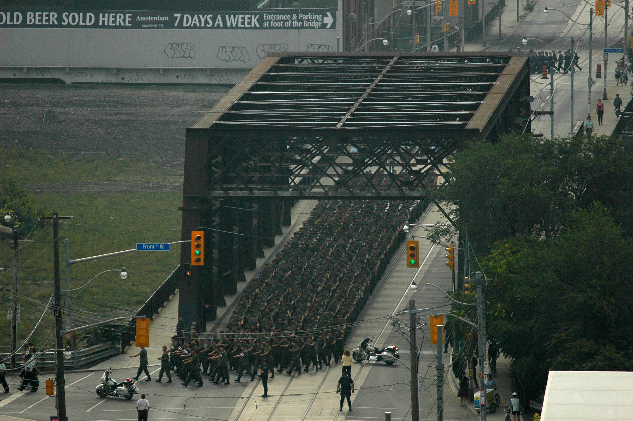
The Sir Isaac Brock Bridge is a steel Warren truss bridge in Toronto, Ontario, Canada. It carries four lanes for motor vehicles with Toronto Transit Commission (TTC)'s streetcar tracks along Bathurst Street over the railway tracks south of Front Street.

The Bridge was formerly named The Bathurst Street Bridge before changing names and being named after Isaac Brock.

The steel truss bridge was built in 1903 and used for the Great Western Railway over the Humber River (northside of then Lakeshore Road at mouth of the river).[1] It was dis-assembled and re-located in 1916 to Bathurst Street and converted for road traffic.[1] The bridge served to connect Bathurst Street at Front Street to Fort York.[2]

In 1931, the bridge was moved and re-aligned (Bathurst Street was at an angle south of Front Street) to support streetcar service south of the railway tracks at that location. A new bridge south of the bridge was constructed to connect the south end of the bridge, connecting Bathurst to Fleet Street. Fort York lost its road access in the change, and a footbridge to the east entrance was constructed.[2]

The Tywn River Drive Bridge, Queen Street Viaduct, and the Old Eastern Avenue Bridge are other examples of steel bridges in Toronto. Lawrence Avenue Bridge was a truss bridge that took traffic over Don River, but it was replaced by the current overpass over the Don River and Don Valley Parkway in the 1960s.

In 2007, the bridge was given the official name of the "Sir Isaac Brock Bridge" by the City of Toronto and East York Community Council.[3] This was done at the instigation of the "Friends of Fort York" organization.

The bridge is owned by Metrolinx, which owns the railway tracks below. It was formerly owned by the Canadian National railway

bathurst bridge by Kevin Steele, on Flickr

1916 Being positioned over the rail lands downtown Toronto.
source: Toronto public Library


It was approved for rehabilitation a few years back but as you can see nothing much at least cosmetically has been done yet.

Img2006-09-17-003 by picturenarrative, on Flickr

Under Bridge 2 by George Welcher, on Flickr

Here is one of it's sister bridges that crosses Queen, it was refurbished over a decade ago.

New Transit on Vintage Bridge by CJ Burnell, on Flickr
Reply With Quote
     
     
  #27  
Old Posted Apr 2, 2020, 6:38 PM
Spocket's Avatar
Spocket Spocket is offline
Back from the dead
 
Join Date: Feb 2006
Location: Edmonton
Posts: 3,508
"This river I step in is not the river I stand in" means....what?
__________________
Giving you a reason to drink and drive since 1975.
Reply With Quote
     
     
  #28  
Old Posted Apr 2, 2020, 9:02 PM
TorontoDrew's Avatar
TorontoDrew TorontoDrew is offline
Registered User
 
Join Date: Nov 2014
Posts: 9,788
Source: http://1000thingstoronto.com

Crossing the Don River, the Queen St Bridge was built in 1911. In 1995, artist Eldon Garnet was commissioned to produce an art installation called ‘Time: and a Clock’. The inscription “This river I step in is not the river I stand in” is borrowed from Greek philosopher Heracleitus, meaning that change is constant in life and experiences. It also reflects how this area has come from an industrial area of glue factories and slaughterhouses to one of Toronto’s hippest neighbourhoods.
Reply With Quote
     
     
  #29  
Old Posted Apr 6, 2020, 3:39 PM
lubicon's Avatar
lubicon lubicon is offline
Suburban dweller
 
Join Date: Jun 2003
Location: Calgary - our road planners are as bad as yours Edmonton
Posts: 5,047
John Hextall Bridge in Calgary has been repurposed for pedestrians. It was originally built by a land developer prior to the First World War.

https://hermis.alberta.ca/ARHP/Detai...ctID=4665-0748

https://www.google.ca/maps/@51.07869...!7i5376!8i2688

There are also several rail trestles on the old Kettle Valley Railway in BC that have been updated and are part of the cycling networks, the Trans Canada Trail etc.
__________________
Two things are infinite: the universe and human stupidity; and I'm not sure about the the universe.

Albert Einstein
Reply With Quote
     
     
  #30  
Old Posted Apr 6, 2020, 8:16 PM
Franco401 Franco401 is offline
Registered User
 
Join Date: Jan 2014
Location: Fredericton
Posts: 1,205
Abandoned road bridge over the Nashwaak River in Fredericton. Still used for power lines, though you can't see them here.

Reply With Quote
     
     
  #31  
Old Posted Apr 12, 2020, 2:43 AM
EasternFreeway's Avatar
EasternFreeway EasternFreeway is offline
Registered User
 
Join Date: Sep 2019
Location: On the road
Posts: 197
Ouch, they forgot a piece of bridge
__________________
Watch my videos on YouTube : https://www.youtube.com/channel/UCQR...vUlXOQ88E7cVDQ
Reply With Quote
     
     
  #32  
Old Posted Apr 13, 2020, 12:04 PM
J.OT13's Avatar
J.OT13 J.OT13 is offline
Moderator
 
Join Date: Mar 2012
Location: Ottawa
Posts: 23,999
The tanker got stuck under the fist piece last time, thus they only had to replace the one. They might have to replace both now.
Reply With Quote
     
     
  #33  
Old Posted Apr 13, 2020, 4:16 PM
esquire's Avatar
esquire esquire is offline
Registered User
 
Join Date: Oct 2001
Posts: 37,483
There are plans to replace that overpass which dates back to 1968. It was hit so many times by over-height trucks that they had to remove part of the decking, so there are plans in the works for a new, taller one... the Province has said they are working on it. But in true Manitoba fashion, even the simplest interchange improvement takes years and years so who knows when it will actually happen. I'd put the over/under on opening day for the new overpass at 3.5 years out.
Reply With Quote
     
     
  #34  
Old Posted Apr 13, 2020, 4:25 PM
J.OT13's Avatar
J.OT13 J.OT13 is offline
Moderator
 
Join Date: Mar 2012
Location: Ottawa
Posts: 23,999
Quote:
Originally Posted by J.OT13 View Post
The tanker got stuck under the fist piece last time, thus they only had to replace the one. They might have to replace both now.
That was supposed to be a joke, but ok then.
Reply With Quote
     
     
  #35  
Old Posted Apr 13, 2020, 4:28 PM
Dengler Avenue's Avatar
Dengler Avenue Dengler Avenue is offline
Road Engineer Wannabe
 
Join Date: Sep 2017
Location: Côté Ouest de la Rivière des Outaouais
Posts: 8,236
Quote:
Originally Posted by J.OT13 View Post
That was supposed to be a joke, but ok then.
Safe to say, road infrastructure in Manitoba is quite the joke~
__________________
My Proposal of TCH Twinning in Northern Ontario
Disclaimer: Most of it is pure pie in the sky, so there's no need to be up in the arm about it.
Reply With Quote
     
     
  #36  
Old Posted Apr 13, 2020, 6:14 PM
TorontoDrew's Avatar
TorontoDrew TorontoDrew is offline
Registered User
 
Join Date: Nov 2014
Posts: 9,788
The Don Branch Railway has 2 or three abandoned bridges in the Don Valley that still exists. Both of these are still standing.

source: torontopubliclibrary.ca


Reply With Quote
     
     
  #37  
Old Posted Apr 13, 2020, 6:35 PM
TorontoDrew's Avatar
TorontoDrew TorontoDrew is offline
Registered User
 
Join Date: Nov 2014
Posts: 9,788
The Evergreen Brickworks, not too long ago it was brought back to life as a place for artists, a few cafe's, seasonal garden centre, farmers markets, and skate rink. Most of the structures remain empty and in the state they were found before being cleaned up.

https://www.evergreen.ca/evergreen-brick-works/
The Don Valley Brick Works was created in 1889 by the Taylor brothers. John Taylor and his brothers, William and George, had purchased the site in the Don Valley in the 1830s where they established a paper mill. While digging post holes to make a fence, William came across some good quality clay.[1] He took a sample to a local brick works where it was confirmed that it would make a high quality brick. A quarry was soon established at the north end of the site and a brick making plant was built at the south end of the property near the Don River.

Part of a series on the
Don Valley
Rivers
Don RiverCastle Frank BrookGerman Mills CreekTaylor-Massey Creek
Parks
Edwards GardensMilne HollowRiverdale Park
History
Crothers WoodsDon Valley Brick WorksJohn TaylorCharles SauriolTodmorden Mills
Environment
Friends of the Don EastTask Force to Bring Back the DonToronto and Region Conservation Authority
vte
The Don Valley Pressed Brick Company produced bricks using three techniques. The first was called a soft-mud process. Clay quarried from the site was mixed with water from nearby Mud Creek, placed in molds which were dried and then baked in kilns. A second technique called dry-press bricks used quarried shale. The shale was placed into molds and machine pressed. A third process called stiff-mud used a mixture of clay and shale that used less water than the soft-mud process. A column of clay was forced through a die which was then cut to form using a wire. Finished product was shipped by cart out of the valley along Pottery Road or by rail on a spur built into the yard. Bricks were used mostly in Toronto but were used across the continent. The bricks made were of such good quality that they won prizes at the Chicago World's Fair in 1893 and the Toronto Industrial Fair in 1894

The Don Valley Brick Works a.k.a Evergreen Brick Works by A Great Capture, on Flickr

ONTARIO-00314 - Outside of the Kiln Tunnel by Dennis Jarvis, on Flickr

ONTARIO-00334 - Brickworks by Dennis Jarvis, on Flickr

Don Valley Brick Works by Andrew Snow, on Flickr

Summertime Reflection by A Great Capture, on Flickr

Blueberries by Robert Greatrix, on Flickr

Let's Go for a Skate by A Great Capture, on Flickr

Evergreen Brickworks, Toronto by wd wilson, on Flickr


2009 before the cleanup.
Brickworks Toronto by marysmyth(NOLA13) ️, on Flickr

Brickworks by Kickin' It, on Flickr
Reply With Quote
     
     
End
 
 
Reply

Go Back   SkyscraperPage Forum > Regional Sections > Canada
Forum Jump


Forum Jump


All times are GMT. The time now is 8:53 AM.

     
SkyscraperPage.com - Archive - Privacy Statement - Top

Powered by vBulletin® Version 3.8.7
Copyright ©2000 - 2024, vBulletin Solutions, Inc.