HomeDiagramsDatabaseMapsForum About
     

Go Back   SkyscraperPage Forum > Regional Sections > Canada > Alberta & British Columbia > Calgary > Calgary Area Photos & Videos


Reply

 
Thread Tools Display Modes
     
     
  #61  
Old Posted Nov 12, 2012, 8:34 PM
Ferreth Ferreth is offline
IMHO
 
Join Date: Apr 2009
Location: Calgary
Posts: 882
Quote:
Originally Posted by 5seconds View Post
This is amazing! Thank you for sharing it.

I have been trying to locate photographs of the Weaselhead area in the years from 1960-1980, and I notice it isn't on here. Can you point me to where you found the originals?
My source, Archive Society of Alberta.

Search for `aerial photograph section` Click on the image in the individual entry description to see a larger version. Note that they estimate the pictures to be from 1970 - they are actually from `73, based on what I see under construction.

There does appear to be some Weaselhead in there. They are in the `SW`numbered grids starting at 1 on the bottom right and moving serpentine to 36 at the top right (same as section numbering in townships, but with their own quadrant labeling instead) You will want 36SW - I`m not seeing 25SW or 35SW so that may be all of the area they covered. If there is more than one image, the second image is a 1975 re-run, of which 36SW is covered as well.

You could try the Alberta Air photo Collection, although I have only been able to find photos as late as 1956 in there, most likely the Weaselhead will be covered somewhere between 1950 and 1955. In fact, I am working on another stitch from 1951 that will include the north eastern part of the Weaselhead, including the bridge crossing the Elbow River.
__________________
---
My Flickr account
My Ratsofrass blog
Reply With Quote
     
     
  #62  
Old Posted Nov 12, 2012, 9:47 PM
5seconds 5seconds is offline
Closed account
 
Join Date: Mar 2011
Posts: 935
Thank you! I have gone through the U of C online photos, and you're right, they end in 1956.

Thanks to you, I have been able to lock down something that has eluded me for a month: What happened to the original Weaselhead bridge (Answer: A crane driving over it was too heavy for the bridge, and it collapsed.)
Reply With Quote
     
     
  #63  
Old Posted Nov 13, 2012, 3:15 AM
mersar's Avatar
mersar mersar is offline
Registered User
 
Join Date: May 2006
Location: Calgary, AB
Posts: 10,083
I'd love to see the KML, quite neat to look at the differences in whats changed over the years.
__________________

Live or work in the Beltline? Check out the Official Beltline web site here
Reply With Quote
     
     
  #64  
Old Posted Nov 13, 2012, 6:16 AM
DarkKeyo DarkKeyo is offline
Transit/Cartography Geek
 
Join Date: May 2008
Location: Burnaby
Posts: 332
Quote:
Originally Posted by Ferreth View Post
Here's something to pore over on a Sunday: a Calgary aerial photo mashed up from some City of Calgary index aerial photos available on archives Alberta. I have loaded a reduced resolution version of the original. If there is interest, I will upload the original KLM file I did in Google, which is fascinating to compare what was there before and what is there now. Both this map and the KLM are not perfect matches due to 3D. I've matched as best I can with a little stretching and rotation, in Google Earth.

Interesting things to find: - Deerfoot end - New Grandstand under construction - NB Edmonton trail bridge under construction - Old runways still visible where MRU is now -Acreages in the NE, soon to be bulldozed - Lynwood Ridge tanks that were going to be a problem for the houses to be built near them - Barlow SE ends before 61st Ave - All the housing north of 50th Ave, south of Peigan, east of the Bow River, still a few holdouts in this now industrial area - Drive in movie theatres, all gone now - huge gravel mines over what is now Riverbend - Racetrack in Braeside - An airport that Deerfoot now runs over - Edmonton trail freshly cutoff by Deerfoot

and as they say, many, many more!
Thank you! I'm always looking for historic photos/maps that I haven't seen before, and this nicely complements my 1971 Calgary entire-city aerial photo wall poster (which was expensive...).
Reply With Quote
     
     
  #65  
Old Posted Nov 14, 2012, 3:36 AM
Ferreth Ferreth is offline
IMHO
 
Join Date: Apr 2009
Location: Calgary
Posts: 882
Quote:
Originally Posted by mersar View Post
I'd love to see the KML, quite neat to look at the differences in whats changed over the years.
I`ve posted it here - good until Nov 20th. Hopefully this works!
__________________
---
My Flickr account
My Ratsofrass blog
Reply With Quote
     
     
  #66  
Old Posted Nov 14, 2012, 4:37 AM
DizzyEdge's Avatar
DizzyEdge DizzyEdge is offline
My Spoon Is Too Big
 
Join Date: Oct 2006
Location: Calgary
Posts: 9,191
Drive-in movie theatre where the centre street superchurch is now.
__________________
Concerned about protecting Calgary's built heritage?
www.CalgaryHeritage.org
News - Heritage Watch - Forums
Reply With Quote
     
     
  #67  
Old Posted Nov 15, 2012, 11:42 PM
jsbertram jsbertram is offline
Registered User
 
Join Date: Sep 2009
Posts: 3,245
Quote:
Originally Posted by DizzyEdge View Post
Drive-in movie theatre where the centre street superchurch is now.
I remember one Drive-in at what is now Point McKay.

Another Drive-in on 17th Ave & 45 St SW, and one more at Memorial & Barlow.

The Sunset was closest to our house, so we'd be there several times in the summer. The station wagon was pulled in back-first so the rear was aimed at the screen. We could let the tailgate down & lay out the sleeping bags. Sometimes it was hot enough in the summer the sleeping bags were put on the roof so we could watch from the 'upper deck'.

Some long weekends the drive-ins would have 'dusk to dawn' programs, but I don't think us kids made it through the first film before zonking out after the sugar rush & crash.


Downloading something from Netflix & watching on a projection screen just ain't the same.
Reply With Quote
     
     
  #68  
Old Posted Nov 16, 2012, 12:38 AM
monocle's Avatar
monocle monocle is offline
cow orker
 
Join Date: Feb 2011
Posts: 437
Memorial and Barlow? Do you recall where? Maybe where Golder,etc is?
Reply With Quote
     
     
  #69  
Old Posted Nov 16, 2012, 1:48 AM
Ferreth Ferreth is offline
IMHO
 
Join Date: Apr 2009
Location: Calgary
Posts: 882
Quote:
Originally Posted by monocle View Post
Memorial and Barlow? Do you recall where? Maybe where Golder,etc is?
Yep, Golder is on the SW corner of the former movie site. Now if only they could do something with the former Firepark site!
__________________
---
My Flickr account
My Ratsofrass blog
Reply With Quote
     
     
  #70  
Old Posted Nov 16, 2012, 2:04 AM
monocle's Avatar
monocle monocle is offline
cow orker
 
Join Date: Feb 2011
Posts: 437
YES! Firepark!
Come on Torrode, think of the SW views from the 60th floor!
Reply With Quote
     
     
  #71  
Old Posted Jan 3, 2013, 12:41 AM
Ferreth Ferreth is offline
IMHO
 
Join Date: Apr 2009
Location: Calgary
Posts: 882
Calgary 1951 aerials

I've been busy over the break putting together a 1951 aerial photo of Calgary. Now that I've finished the long process of adding image overlays, I can also do things like oblique shots as well. The first image is huge - best viewed in original 5000x7000pixel version if you want to explore buildings etc. You'll see there that the developed part of the city is almost all in high resolution, with the outer areas in lower resolutions. I did have to cheat just a bit in the Weaselhead flats as I could find no image for some of that area. Enjoy exploring!


Calgary Aerial 1951 large by ferreth, on Flickr


Calgary 1951 oblique aerial by ferreth, on Flickr
__________________
---
My Flickr account
My Ratsofrass blog
Reply With Quote
     
     
  #72  
Old Posted Jan 3, 2013, 1:18 AM
srperrycgy's Avatar
srperrycgy srperrycgy is offline
I'm the bear on the right
 
Join Date: Jun 2004
Location: Calgary (Killarney)
Posts: 1,665
Wow! Very, very impressive!
__________________
Stevinder.
* * * * * *
Reply With Quote
     
     
  #73  
Old Posted Jan 3, 2013, 1:29 AM
5seconds 5seconds is offline
Closed account
 
Join Date: Mar 2011
Posts: 935
That looks great!
Reply With Quote
     
     
  #74  
Old Posted Jan 3, 2013, 1:48 AM
Nudrock Nudrock is offline
Registered User
 
Join Date: Aug 2006
Location: Calgary since 1983
Posts: 203
I appreciate your effort in doing this. It looks great.
I'm a bit surprised that certain areas were not developed back then.
Reply With Quote
     
     
  #75  
Old Posted Jan 3, 2013, 3:04 AM
DizzyEdge's Avatar
DizzyEdge DizzyEdge is offline
My Spoon Is Too Big
 
Join Date: Oct 2006
Location: Calgary
Posts: 9,191
Note the Chinook Drive-In theatre, and I believe the Chinook Park race track.
__________________
Concerned about protecting Calgary's built heritage?
www.CalgaryHeritage.org
News - Heritage Watch - Forums
Reply With Quote
     
     
  #76  
Old Posted Jan 3, 2013, 3:52 PM
freeweed's Avatar
freeweed freeweed is offline
Home of Hyperchange
 
Join Date: Sep 2006
Location: Dynamic City, Alberta
Posts: 17,566
Dear god man, that is... breathtaking!

Like the 1950s skyline video someone dug up - it's like an entirely different city. The rivers, CPR lines, and a few major roads are the same - and that's about it. This more than anything shows how much Calgary truly is a product of the late 20th century. Moreso than almost any other city I can think of (except maybe Vegas).

It also really has me both scared and excited for what will change in the rest of my lifetime. 2 million? 3 million? What will our city look like in another 50-60 years?
__________________
Suburbs are the friends with benefits of the housing world.
Reply With Quote
     
     
  #77  
Old Posted Jan 3, 2013, 8:24 PM
Ferreth Ferreth is offline
IMHO
 
Join Date: Apr 2009
Location: Calgary
Posts: 882
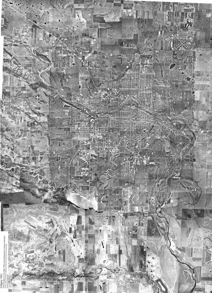
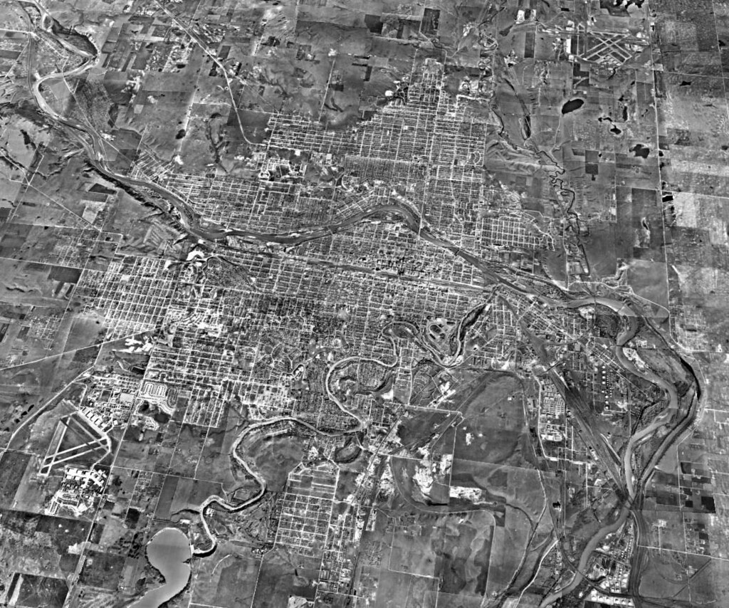
Thanks for all the kind words. You look at Calgary in 1951 and suddenly understand how certain bottlenecks were already set in stone. No city planner would have been planning for the million plus people we have today; it would have been very far forward thinking about 500K in the city at that time of 129K.

You can see that the construction for the new highway 1 on 16th Ave is just beginning at this point at Barlow & 16th. 16th Ave TCH, would have seemed to be all that would ever be needed and a huge improvement over 17th Ave/9th Ave/10th St/16th Ave/Banff trail route!

What also struck me is how comparatively ugly the city would have been at the time. I'm sure other cities were similar - rail yards and industrial along several prime river locations in town. Expectations were different then.

You would think that only in the age of satellites and jet planes that anyone would have thought to write anything on the roof of their building. But even in 1951 when flying was expensive and a lot slower, you can find an arrow pointing to "Calgary 2 M" on top of one of the tanks at the Lynwood Ridge refinery.

At that point, there was no confusion - Edmonton Trail really did go to Edmonton. What I didn't know is that a rail spur line went to the McCall Airport. At least the earth works continued off into the NE ending around Stoney and 64th. I assume it served the air force during WWII, but the only thing I can think of for a NE spur is a temporary line to bring in fill for the airport. The line isn't even listed in "Lines of Country: An Atlas of Railway and Waterway History in Canada", so it might have been very ephemeral.

1951 also marks the transition from building grid streets to curvilinear. You can see the new houses in Renfrew and Currie Barracks going up with curvilinear streets. It's hard to believe that some of these houses have already been torn down for infill. Speaking of the military, you can see at this time it had a huge impact on the Calgary economy. The buildup is just about at it's zenith and would already be declining in areas like McCall field.

I still have one mystery development I have no idea what it is - the patch small houses and slightly larger sized buildings north of 17th Ave NE, in fact the scar remaining from that development is visible to the present. Motor park perhaps?
__________________
---
My Flickr account
My Ratsofrass blog
Reply With Quote
     
     
  #78  
Old Posted Jan 3, 2013, 8:50 PM
Wooster's Avatar
Wooster Wooster is offline
Round Head
 
Join Date: Nov 2003
Posts: 12,688
A lot of fun to look at.
Reply With Quote
     
     
  #79  
Old Posted Jan 3, 2013, 8:56 PM
Calgarian's Avatar
Calgarian Calgarian is offline
Registered User
 
Join Date: Jun 2006
Location: Calgary, AB
Posts: 24,072
That is really neat, well done!
__________________
Git'er done!
Reply With Quote
     
     
  #80  
Old Posted Jan 3, 2013, 9:00 PM
freeweed's Avatar
freeweed freeweed is offline
Home of Hyperchange
 
Join Date: Sep 2006
Location: Dynamic City, Alberta
Posts: 17,566
Hey - did you create that as a layer on top of Google Earth, so you can transition between then and now? Not sure how to show this effect in a static picture, but it would be uber cool.
__________________
Suburbs are the friends with benefits of the housing world.
Reply With Quote
     
     
This discussion thread continues

Use the page links to the lower-right to go to the next page for additional posts
 
 
Reply

Go Back   SkyscraperPage Forum > Regional Sections > Canada > Alberta & British Columbia > Calgary > Calgary Area Photos & Videos
Forum Jump


Forum Jump


All times are GMT. The time now is 7:31 AM.

     
SkyscraperPage.com - Archive - Privacy Statement - Top

Powered by vBulletin® Version 3.8.7
Copyright ©2000 - 2024, vBulletin Solutions, Inc.