City council approves zoning amendment for proposed four-tower development near Petrie Island
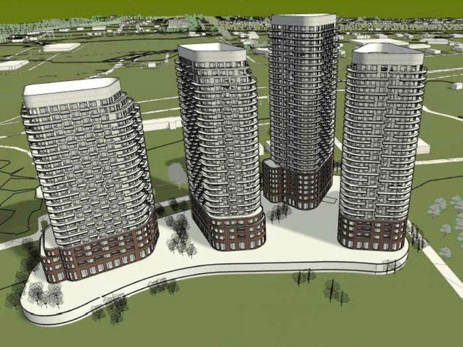
The proposal for the property on Tweddle Road is now pitching a maximum of four towers with variations in height between 20 and 35 storeys, each on podiums between four and six storeys tall.
Joanne Laucius, Ottawa Citizen
Nov 09, 2022 • 59 minutes ago • 4 minute read
Ottawa city council has approved a zoning amendment to allow for up to four residential towers as much as 35 storeys tall to be built near Petrie Island in Orléans.
The proposal for the property on Tweddle Road is now pitching a maximum of four towers with variations in height between 20 and 35 storeys, each on podiums between four and six storeys tall. The towers would be within walking distance of the Trim Road LRT station.
The proponent for the project is a numbered company from Quebec. According to its plans, the property would include accessible space providing views of the Ottawa River and opportunities to link public space to Tweddle Road with the intent of creating a “gateway” for pedestrians and cyclists.
The city received about 120 comments from the public about the proposal to allow for up to four towers, including concerns about the scale of the project and worries about the possibility of flooding or landslides, as well as damage to the Ottawa River and its ecology.
The site is only 30 metres from the boundary of a provincially significant wetland and near Petrie Island, home to wildlife including the threatened Blanding’s Turtle.
In a joint open letter to council, the Community Associations for Environmental Sustainability, Ecology Ottawa, the Greater Avalon Community Association and the Greenspace Alliance of Canada’s Capital urged councillors to refuse to approve the amendment.
“Developing this site for all of Ottawa as a natural reserve and protected wetland with appropriate recreational use is a better forward–looking alternative with benefits for all of Ottawa,” they said.
Orléans Coun. Matthew Luloff said the application has been ongoing for over two years. He said he has received a lot of emails about the site containing “much misinformation.”
“Staff have set a very high bar for this application,” he told council.
“The zoning that was requested was to bring the property in line with the official plan, and the Orléans secondary plan — the latter of which, by the way, was passed unanimously by this council. This specific property was identified in the secondary plan for this type of development.”
Members of the city’s planning committee, which voted in favour of the zoning amendment on Oct. 27, also fielded concerns.
River Ward Coun. Riley Brockington said delegations have brought forward some legitimate concerns, including flood risk.
“Obviously we don’t want a major development built here and then be submerged the next time we have a freshet in the spring,” said Brockington.
Capital Ward Coun. Shawn Menard, who is also on the planning committee, told council he heard concerns about flooding, landslide risk and disturbance to wildlife.
Menard presented a motion to council, which passed, that a landslide risk assessment be updated to the satisfaction of the Rideau Valley Conservation Authority.
According to the city, the landowners have indicated apartments will be rented at market value, but city staff will continue to discuss opportunities for affordable housing as part of the site plan control approval process.
City staff say the site will be 30 feet above the existing floodplain line. Building heights will be in accordance with the Orléans corridor secondary plan. All urban development will remain out of the lands deemed environmentally significant, including the woodlands and wetlands.
Paul Johanis, chair of the Greenspace Alliance of Canada’s Capital, said there were some small victories in council’s decision on Wednesday, including Menard’s motion for an updated landslide risk assessment.
The Greenspace Alliance had proposed that the city suggest a land swap, with the project proponent swapping the Tweddle Road land on the river for a nearby city works yard on Jeanne d’Arc Boulevard that now contains storage for road salt. While the city site would require remediation because of the salt, the towers would no longer be on the river, it said.
There has been no response to the proposal, but Johanis is hopeful that a new mayor and council may see things differently.
“Maybe the matter will be re-opened, said Johanis. “They have to get different studies done. It’s a big change in council, so who knows?”
One of the things that concerns Johanis is the growing number of apartment towers in the proposal. When he first heard about project, he said there were two proposed towers, and then a third was added. He said he only learned about the fourth tower nine days before the planning committee meeting on Oct. 27.
Luloff noted that no buildings were approved Wednesday and no buildings would be approved until the site plan review.
“And should they be approved, it will be because the applicant has met or exceeded the requirements set forth by legislation and the Rideau Valley Conservation Authority,” he said.
https://ottawacitizen.com/news/local...-petrie-island


 Prev
Prev


 Linear Mode
