HomeDiagramsDatabaseMapsForum About
     

Go Back   SkyscraperPage Forum > Regional Sections > Canada > Ontario > Hamilton > Transportation & Infrastructure


Reply

 
Thread Tools Display Modes
     
     
  #2801  
Old Posted Jun 8, 2015, 1:30 PM
HillStreetBlues HillStreetBlues is offline
Registered User
 
Join Date: Apr 2013
Location: KW/Hamilton, Ontario
Posts: 995
Quote:
Originally Posted by mattgrande View Post
MacNab? Why MacNab? Why not Hunter? How will they connect MacNab to the station? So many questions...
Presumably it has to be MacNab and then Hunter, since MacNab is two blocks west of the station.

Is this just to serve (justify?) the MacNab terminal? James or Hughson would be much better. It must be because MacNab is not useful for vehicular traffic, but not is Hughson. We could have a pedestrianized route from the James/King (or Main...) LRT station and the Gore to the Go Station.

The only reason I might be in favour of this routing is because MacNab is designed Franz Liszt Avenue through there: maybe we could further honour him somehow if this is where the "pedestrian link" is put.
Reply With Quote
     
     
  #2802  
Old Posted Jun 8, 2015, 1:52 PM
davidcappi's Avatar
davidcappi davidcappi is offline
Registered User
 
Join Date: Oct 2013
Posts: 1,992
Anyone want to get a screengrab of that plan in the article? I'm out of free views
Reply With Quote
     
     
  #2803  
Old Posted Jun 8, 2015, 3:02 PM
markbarbera markbarbera is offline
Registered User
 
Join Date: May 2007
Location: Hamilton
Posts: 3,050
This is a bad attempt to try to make MacNab terminal an inter-modal hub rather than the lame-duck terminal it currently is. It really is nothing more than a turnaround point for mountain buses.

If anyone had any good transit sense, the idea of a terminal at MacNab should have been abandoned when it was due for a rebuild a few years ago. Instead of rebuilding it at MacNab and King, it should have been placed along Hughson between Main and Hunter, Why have a needlessly long pedestrian connection from MacNab and King to Hunter and James when it could have been centrally located on Hughson where it would be within one block of the nearly every HSR, GO Transit, and all other inter-city bus route that serves the city.

Perhaps this is another opportunity to correct a bad layout rather than simply accepting another duct tape fix.
__________________
"A government that robs Peter to pay Paul can always depend on the support of Paul"
-George Bernard Shaw
Reply With Quote
     
     
  #2804  
Old Posted Jun 8, 2015, 5:22 PM
SteelTown's Avatar
SteelTown SteelTown is online now
It's Hammer Time
 
Join Date: Mar 2004
Location: Hamilton
Posts: 19,889
Quote:
Originally Posted by davidcappi View Post
Anyone want to get a screengrab of that plan in the article? I'm out of free views
Can't really see it well, itty bitty.
Reply With Quote
     
     
  #2805  
Old Posted Jun 8, 2015, 5:36 PM
MalcolmTucker MalcolmTucker is offline
Registered User
 
Join Date: May 2007
Posts: 11,440
The image quality in the paper itself was pretty awful:

Source: Hamilton Spectator via: http://library.pressdisplay.com/pres...ay/viewer.aspx
Reply With Quote
     
     
  #2806  
Old Posted Jun 8, 2015, 7:01 PM
ScreamingViking's Avatar
ScreamingViking ScreamingViking is offline
Ham-burgher
 
Join Date: Jun 2013
Location: Hamilton
Posts: 6,559
This "early concept" doesn't make the best sense IMO, even if the planners are thinking they can maximize access to both GO and the HSR's main downtown transfer node. The pedestrian corridor should be as direct as possible to be the most useful. MacNab and Hunter to the GO Centre is nearly twice the distance of a Hughson link, depending on where the B-Line stations will be (personally I think a station at Gore Park and a station at Bay St. would be best, rather than a single station in the core). And the main idea is to connect the LRT to the GO station.

This is an opportunity to plan creatively rather than trying to make piecemeal changes to what exists today. Instead of making the LRT fit into the HSR system, the HSR system needs to be organized to fit the LRT, as well as the future expanded GO services.

E.g., what if Hunter was made two-way, with bus stops under continuous canopies along both sides? No more on-street parking, but direct local bus access can be improved. They don't even have to stop using MacNab -- buses that terminate there can still do so, with route adjustments to make a stop on Hunter as well.
Reply With Quote
     
     
  #2807  
Old Posted Jun 8, 2015, 7:46 PM
HillStreetBlues HillStreetBlues is offline
Registered User
 
Join Date: Apr 2013
Location: KW/Hamilton, Ontario
Posts: 995
Quote:
Originally Posted by ScreamingViking View Post
This "early concept" doesn't make the best sense IMO, even if the planners are thinking they can maximize access to both GO and the HSR's main downtown transfer node. The pedestrian corridor should be as direct as possible to be the most useful. MacNab and Hunter to the GO Centre is nearly twice the distance of a Hughson link, depending on where the B-Line stations will be (personally I think a station at Gore Park and a station at Bay St. would be best, rather than a single station in the core). And the main idea is to connect the LRT to the GO station.

This is an opportunity to plan creatively rather than trying to make piecemeal changes to what exists today. Instead of making the LRT fit into the HSR system, the HSR system needs to be organized to fit the LRT, as well as the future expanded GO services.

E.g., what if Hunter was made two-way, with bus stops under continuous canopies along both sides? No more on-street parking, but direct local bus access can be improved. They don't even have to stop using MacNab -- buses that terminate there can still do so, with route adjustments to make a stop on Hunter as well.
I think your ideas about Hunter is a great one, but we really would have to stop using MacNab in that case. There’s nothing wrong with that- we should be able to admit if it no longer fits. If we do as you suggest with Hunter and turn it into a local bus hub right adjacent to the Go station- and accessible to an LRT station via a pedestrian connection- that’s much better than what could be done with MacNab.
Reply With Quote
     
     
  #2808  
Old Posted Jun 8, 2015, 9:49 PM
ScreamingViking's Avatar
ScreamingViking ScreamingViking is offline
Ham-burgher
 
Join Date: Jun 2013
Location: Hamilton
Posts: 6,559
Quote:
Originally Posted by HillStreetBlues View Post
I think your ideas about Hunter is a great one, but we really would have to stop using MacNab in that case. There’s nothing wrong with that- we should be able to admit if it no longer fits. If we do as you suggest with Hunter and turn it into a local bus hub right adjacent to the Go station- and accessible to an LRT station via a pedestrian connection- that’s much better than what could be done with MacNab.
It depends if some routes would still make sense to stop there -- since it's closer to Jackson Square and major office towers, plus the new Mac medical building.

The HSR should do a review of all of its routes and scheduling and make changes according what would provide the greatest efficiency for the operating dollars across the transit network with the LRT and new GO services in place. #1 would be expanding A-Line service... something that should have been done already never mind when LRT is built and GO is running more trains, because it's currently not well-matched to the GO schedule we have.
Reply With Quote
     
     
  #2809  
Old Posted Jun 15, 2015, 4:36 PM
thomax's Avatar
thomax thomax is offline
Registered User
 
Join Date: May 2012
Location: Toronto
Posts: 5,380
Quote:
thespec.com: Paling Ave. real estate listings already touting proximity to LRT


Proximity to a future LRT line is expected to have a positive impact on
house sales.


By Amy Kenny | June 15, 2015

"Walk to the new LRT" — that's the description for a real estate listing on Paling Avenue, just east of Kenilworth Avenue North.

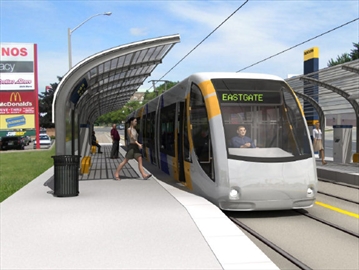
No matter that construction on the city's light rail transit line isn't slated to begin until 2019, for a 2024 opening. It's already bringing buzz to the proposed corridor — from McMaster University in the west to the Queenston traffic circle in the east, with a spur line that connects to the new GO station on James Street North.

Coun. Sam Merulla, who represents Ward 4 where the house on Paling is located, says he's not surprised real estate listings are pushing proximity to LRT.

He says a similar thing happened in 2007 when the Red Hill Valley Parkway opened.

"This was a catalyst to Torontonians looking for housing stock in an urban centre," he says, noting property values had jumped for the first time in years.

Before that, Torontonians moved to Westdale, says James Pottruff, with Pottruff and Oliver Realty Inc., Brokerage. He says the Red Hill parkway opened up the Stoney Creek Mountain to newcomers, and thinks LRT will have an even greater impact on the city's east end.

"Lots of (Torontonians) have a different psyche sometimes," he says.

"I think they're very conscious of LRT because they've been used to taking public transit."

Pottruff says LRT seems to hold greater attraction for out-of-towners than it does for established Hamiltonians, who might have a more car-centric mentality.

It's just the latest spike in what Pottruff calls an unprecedented run of price increases in the city. He says the real estate market in Hamilton is the craziest he's seen it in his 31 years as an agent and the LRT announcement has definitely prompted people to ask about locating along the line.

That's not the case across the board in his industry, however.

"To be honest, I think it's too early," says Jeannie Crawford, an agent with Coldwell Banker Pinnacle. "I deal with a lot of people coming to Hamilton from other cities and many haven't even heard of this development. They are all talking about wanting to be near the GO Station on James, but that is real and tangible. Once we get closer to (LRT) and things start to really happen, then I think we'll see more immediate effects."

Pottruff says he can't guess how property values will change along the LRT corridor as construction comes closer, but there are examples of it in other cities.

According to a 2010 report prepared for the City of Hamilton by the Canadian Urban Institute, property values of homes along the LRT route in Dallas, Texas, were 25 per cent higher than values elsewhere in the city. In Portland, Ore., homes within 500 metres of LRT had a 10.6 per cent price premium.

The report also highlighted potential for new development.

"This study has found that the proposed B-Line LRT would stimulate an additional 350,000 square metres (3.7 million square feet) of development over a 15-year period relative to development in the area without an LRT," read the report.

That development would bring an expected $280 million in new taxable assessment, with estimated tax revenues of $22.4 million over 15 years.

Additionally, property values along the corridor would increase to bring $29 million in taxes over that period, with another $30 million coming from building permit and development fees.


Listing: realtor.ca - 124 Paling Avenue, Hamilton, Ontario | $357,900 | 4+1 Bedrooms | 3 Bathrooms

It's not mentioned in the story, but the house sold the first weekend it was for sale for above the asking price.
Reply With Quote
     
     
  #2810  
Old Posted Jun 16, 2015, 5:05 PM
drpgq drpgq is offline
Registered User
 
Join Date: Dec 2007
Location: Hamilton/Dresden
Posts: 1,809
^^^

That makes me have to wonder what the people in Ward 5 are thinking after the change to stop the LRT at the Queenston traffic circle. Normally a councilor in that situation would be complaining, but Chad Collins thinks it is success.
Reply With Quote
     
     
  #2811  
Old Posted Aug 5, 2015, 5:16 PM
lucasmascotto's Avatar
lucasmascotto lucasmascotto is offline
Registered User
 
Join Date: Feb 2012
Location: Hamilton
Posts: 356
First phase of $1B Hamilton LRT will also connect to waterfront
(The Hamilton Spectator: Wednesday, August 05, 2015)
By: Matthew Van Dongen

Hamilton needs to get rolling immediately on design changes to a King Street corridor LRT that will now also connect the downtown to the waterfront, a new report says.

Construction on an 11-kilometre, $1 billion light rail line connecting McMaster University to the Queenston traffic circle is not scheduled to begin before 2019.

But the city and provincial overseer Metrolinx still face an "aggressive" timeline for years of planning and design work needed to for the project — which now includes a spur line from the downtown to the James Street GO station and beyond, according to the city's first comprehensive report on the LRT project made public today.

Premier Kathleen Wynne announced the long-coveted LRT cash this spring with a caveat the project must connect to the city's new GO Station. Construction of a planned east city GO station starting in 2017 was promised as well.

A map included in the city's new report shows a north-south connection — essentially part of the city's hoped-for future "A" line LRT — extending from the King Street corridor right to the edge of the harbour via the west harbour GO Station.

It's unclear if the connection to the waterfront represents a rail spur all the way to Guise Street East, or if shuttles would run the remaining distance from the GO station.

The map also reflects a planned pedestrian connection from the King Street LRT to the Hamilton GO Centre that also requires major design work.

The report also talks about the need to immediately form an LRT project office and subcommittee of councillors.

A memorandum of agreement with project lead Metrolinx — which would outline responsibility for various costs — needs to be signed within the next 12 to 24 months.

Council also needs to chew on zoning requirements along the LRT route, since existing zoning rules outside the downtown don't necessarily fit the economy-boosting vision for development along the corridor.

More to come.
Reply With Quote
     
     
  #2812  
Old Posted Aug 5, 2015, 5:25 PM
lucasmascotto's Avatar
lucasmascotto lucasmascotto is offline
Registered User
 
Join Date: Feb 2012
Location: Hamilton
Posts: 356
City will hire designers for LRT system this month
(CBC Hamilton: Wednesday, August 05, 2015)
By: Samantha Craggs

The city will move ahead with its light rail transit dream next week when it will establish an office and hire a company to design the $1-billion system.

City councillors will vote Monday whether to create an LRT office, hire Steer Davies Gleave to do the conceptual design and environmental assessment, and hammer out a memorandum of agreement with Metrolinx.

It's the next step in a plan to bring LRT to Hamilton's lower city. In May, Premier Kathleen Wynne announced full capital funding to build the long-awaited system from McMaster University to the Queenston traffic circle.

Monday's decisions will be the first concrete moves after Wynne's announcement to fund the system, which will see construction start in 2019.

The designers will factor in any necessary changes for the line, which will include a spur line to the West Harbour GO station on James Street North. Those designs will include a pedestrian corridor and connecting to a maintenance and storage facility for the trains.

Metrolinx is the lead agency on the project and expects to start procurement for Hamilton's LRT line by 2017.

The province is also paying for a new GO station at Centennial Parkway, which will be finished by 2019.

Here are some other highlights of the report:

It will cost the city $2,096,294 for Steer Davies Gleave's work. The technical work will start in August and finish in March 2017. It is "staff's understanding" that Metrolinx will pay for that, city manager Chris Murray says in the report.
The memorandum of understanding will take about 12 to 18 months to finish and will deal with details such as who oversees which parts of the project.
The new LRT office will include a project lead, transit lead, planner and communications person, and also use experts in engineering, real estate law and finance. Metrolinx will, "we believe," cover the staffing costs, the report says.
The report recommends looking at area rating for transit, although says that the status quo, where urban areas pay predominantly for transit, will be "a consideration and a possible outcome."

Councillors will discuss the report at 9:30 a.m. on Monday.
Reply With Quote
     
     
  #2813  
Old Posted Aug 5, 2015, 5:30 PM
SteelTown's Avatar
SteelTown SteelTown is online now
It's Hammer Time
 
Join Date: Mar 2004
Location: Hamilton
Posts: 19,889
Reply With Quote
     
     
  #2814  
Old Posted Aug 5, 2015, 11:59 PM
Dr Awesomesauce's Avatar
Dr Awesomesauce Dr Awesomesauce is offline
Registered User
 
Join Date: Jan 2010
Location: BEYOND THE OUTER RIM
Posts: 5,889
^Never in my wildest dreams - very exciting!

Curious about this 'pedestrian connection' too. I wonder what that might be...
Reply With Quote
     
     
  #2815  
Old Posted Aug 6, 2015, 12:43 PM
HillStreetBlues HillStreetBlues is offline
Registered User
 
Join Date: Apr 2013
Location: KW/Hamilton, Ontario
Posts: 995
This morning’s Spec article on the topic made it seem as though this extension was entirely Eisenberger’s idea, and had not been seen let alone approved by Metrolinx. It would be great, but I wonder how much extra it would cost. If this thing is a branch taken by some east-west trains, I can see it decreasing the utility of the line by effectively decreasing the frequency for cross-town trips.

What would be great? We have a billion-dollar commitment from the province, the municipality should kick in the extra cost to actually build the A Line, since the plan might now include a couple kilometres of it.
Reply With Quote
     
     
  #2816  
Old Posted Aug 6, 2015, 2:23 PM
Beedok Beedok is online now
Exiled Hamiltonian Gal
 
Join Date: Jun 2012
Posts: 6,808
So by the time I'm in my 30s Hamilton will get its transit act together....
Reply With Quote
     
     
  #2817  
Old Posted Aug 6, 2015, 2:43 PM
lucasmascotto's Avatar
lucasmascotto lucasmascotto is offline
Registered User
 
Join Date: Feb 2012
Location: Hamilton
Posts: 356
I'll be 29/30 by the time the LRT line opens! I'm so excited!
Reply With Quote
     
     
  #2818  
Old Posted Aug 6, 2015, 5:21 PM
NortheastWind NortheastWind is offline
Registered User
 
Join Date: Feb 2011
Posts: 621
Here is the page for Hamilton's B-Line on the Steer Davies Gleave website
Reply With Quote
     
     
  #2819  
Old Posted Aug 6, 2015, 5:38 PM
HillStreetBlues HillStreetBlues is offline
Registered User
 
Join Date: Apr 2013
Location: KW/Hamilton, Ontario
Posts: 995
Quote:
Originally Posted by NortheastWind View Post
Here is the page for Hamilton's B-Line on the Steer Davies Gleave website
Their map of the 'BLAST' system shows the B Line continuing all the way to Fruitland. I've never seen that one before, I don't think...
Reply With Quote
     
     
  #2820  
Old Posted Aug 6, 2015, 5:46 PM
Beedok Beedok is online now
Exiled Hamiltonian Gal
 
Join Date: Jun 2012
Posts: 6,808
Quote:
Originally Posted by lucasmascotto View Post
I'll be 29/30 by the time the LRT line opens! I'm so excited!
I think that makes you 20 then?

Quote:
Originally Posted by HillStreetBlues View Post
Their map of the 'BLAST' system shows the B Line continuing all the way to Fruitland. I've never seen that one before, I don't think...
I've seen that.

https://raisethehammer.org/article/2...iminary_review
Reply With Quote
     
     
This discussion thread continues

Use the page links to the lower-right to go to the next page for additional posts
 
 
Reply

Go Back   SkyscraperPage Forum > Regional Sections > Canada > Ontario > Hamilton > Transportation & Infrastructure
Forum Jump


Forum Jump


All times are GMT. The time now is 1:45 PM.

     
SkyscraperPage.com - Archive - Privacy Statement - Top

Powered by vBulletin® Version 3.8.7
Copyright ©2000 - 2024, vBulletin Solutions, Inc.