Quote:
Originally Posted by Fireoutofclay

I appreciate the Google estimates, but there is absolutely a variance in ground level, at least with regard to the Weston Centre. And I'm not suggesting that the Weston was built on the top of a cliff, but it is at a higher level than its immediate area.
|
The discussion was about whether or not the Weston Center sat at I higher elevation than the Marriott River Center and the Grand Hyatt...and the answer is no. the Google estimates are pretty close especially when comparing different locations throughout downtown.
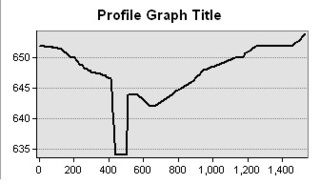
As I showed in my post I looked at Google elevations as well as COSA elevation data. St Marys St is a low point that is why it seems as if the Weston Center sits up on a perch. However by the time you get to the Street level at Travis Park the elevation is the same as the entrance to the Weston Center (652'). Below is an elevation profile of Pecan from Soledad to Jefferson; that illustrates this. The abrupt drop in the River (Pecan Obviously does not drop that way).
I used elevation point data that the city has processed every 3-5 years. Based on this data the Hyatt and the Marriott have entrances that are 4' higher in elevation than the Weston Center.
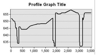
Below is a profile drawn from the entrance of the Weston Center to the Entrance of the Marriott River Center. The first low point is the River next to the Weston Center, the second is Paseo de Alamo, and the third is the River extension at River Center Mall. The lowest point in the profile (not river level) is 644; a staggering 8 feet beneath the Weston Center Entrance.
Once again:
Marriott River Center - 656
Grand Hyatt - 656
Weston Center -652
New Frost - 650
Tower Life - 641
River View - 648
Frost - 650
Drury - 646
Municipal Plaza - 650
Nix - 644
BofA - 648
USAA - 646
AT&T - 651
Hemisfair Tower - 652
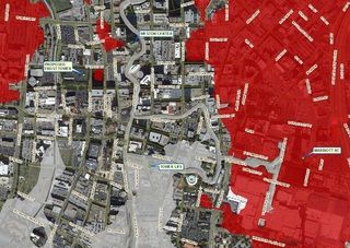
That is fairly flat to me, when comparing perceived heights. Are there areas around downtown that are lower than the intersection of Pecan and Soledad? Sure, but the majority of downtown is between 642' and 652'.
The gray areas are below 642' and the red areas are above 652'


 Prev
Prev


 Linear Mode
