HomeDiagramsDatabaseMapsForum About
     

Go Back   SkyscraperPage Forum > Regional Sections > Canada


Reply

 
Thread Tools Display Modes
     
     
  #61  
Old Posted Feb 6, 2009, 8:42 PM
Rathgrith's Avatar
Rathgrith Rathgrith is offline
I'm just joking.
 
Join Date: Sep 2007
Location: Ottawa
Posts: 1,176
Quote:
Originally Posted by blake10 View Post

The problem with a center lane is that it can become a "suicide lane" even if only one direction is supposed to be using it at any one time.
Exactly. Doing that would be like building highway 69 in Ontario all over again. I have one memory as a 6 year old waiting on highway 69 after a horrific car cars that shut down the entire highway. At least Highway 11 to North Bay and Highway 69 400 to Sudbury are being twinned right now.
Reply With Quote
     
     
  #62  
Old Posted Feb 7, 2009, 1:03 AM
cornholio cornholio is offline
Registered User
 
Join Date: Jun 2006
Posts: 3,911
Quote:
Originally Posted by blake10 View Post
The problem with a center lane is that it can become a "suicide lane" even if only one direction is supposed to be using it at any one time.
Well lot of highways in BC are 3 lane for obvious reasons, including the upgrded sea to sky to whistler. You just have 2 lanes in one direction and one lane in the other, ever 5-10km the second lane merges back while the oposite direction turns to a two lane highway. This way you have a smaller right of way but people can always pass every few km, naturally the slower traffic will create a gap ahead of it so once you pass it then you can rip it down the one lane highway for a good stretch until you hit another car to pass, at which point you wait for the pass lane and continue.

Im assuming you were thinking of a center lane that is used for passing for both directions at the same time, now that is allot more dangerous than just having a 2 lane highway and just passing when you have a opportunity.
Reply With Quote
     
     
  #63  
Old Posted Feb 7, 2009, 1:15 AM
blake10 blake10 is offline
Registered User
 
Join Date: Jan 2009
Location: Winnipeg
Posts: 61
Quote:
Originally Posted by cornholio View Post
Well lot of highways in BC are 3 lane for obvious reasons, including the upgrded sea to sky to whistler. You just have 2 lanes in one direction and one lane in the other, ever 5-10km the second lane merges back while the oposite direction turns to a two lane highway. This way you have a smaller right of way but people can always pass every few km, naturally the slower traffic will create a gap ahead of it so once you pass it then you can rip it down the one lane highway for a good stretch until you hit another car to pass, at which point you wait for the pass lane and continue.

Im assuming you were thinking of a center lane that is used for passing for both directions at the same time, now that is allot more dangerous than just having a 2 lane highway and just passing when you have a opportunity.
I see what you mean now. The section between the MB border and Kenora (I don't know about Kenora->TB, however) does have quite a few passing lanes (certainly not the whole way, but there are enough), but although this helps, only a true divided highway will really make the road safer.
Reply With Quote
     
     
  #64  
Old Posted Feb 7, 2009, 6:01 AM
e909 e909 is offline
Registered User
 
Join Date: Sep 2005
Location: Edmonton, AB
Posts: 882
I have to drive this stretch soon (Winnipeg to Ottawa).

Should I take Highway 11 or 17 (From Thunderbay to North Bay)? Which is less dangerous.
Reply With Quote
     
     
  #65  
Old Posted Feb 7, 2009, 7:22 AM
urbanfan89's Avatar
urbanfan89 urbanfan89 is offline
Registered User
 
Join Date: Feb 2008
Posts: 501
Highway 17 is shorter, and much of it is three/four lanes. Because it's further south, there should be fewer stretches of driving without any signs of civilization.
Reply With Quote
     
     
  #66  
Old Posted Feb 7, 2009, 11:39 AM
vid's Avatar
vid vid is offline
I am a typical
 
Join Date: Apr 2004
Location: Thunder Bay
Posts: 41,172
Highway 11 is desolate. Only use that if you have to go up there or like not being near anything whatsoever for long periods of time.

The Trans-Canada up here has climbing lanes and passing lanes, which are the same thing as the three lane idea but on the outside and spread apart a little more. You can see examples by following 11/17 east, it starts off with two lanes eastbound and one west, then alternates, then is two lane for a few kilometres.

There is a new right of way that the province is establishing in Shuniah, this will result in three east-west corridors in that area (Lakeshore Drive, the original TCH; the current TCH; and the future one) and I think they're finished environmental reports, it's supposed to start construction on Insert Future Date Here.

Should note however, that the stretch of Highway 11/17 and Former 11/17 west of Thunder Bay have claimed many lives in the past year. People don't seem to understand how to use the new highway.

The stretch of highway near Kenora is in Conservative ridings. North-east of Thunder Bay along the shoreline is in a former Conservative riding, now NDP, so I doubt it will see any funding, as non-partisanship doesn't exist in Canada.
Reply With Quote
     
     
  #67  
Old Posted Feb 7, 2009, 6:05 PM
Andy6's Avatar
Andy6 Andy6 is offline
Starring as himself
 
Join Date: Mar 2002
Location: Toronto Yorkville
Posts: 9,739
Quote:
Originally Posted by vid View Post
Highway 11 is desolate. Only use that if you have to go up there or like not being near anything whatsoever for long periods of time.

The Trans-Canada up here has climbing lanes and passing lanes, which are the same thing as the three lane idea but on the outside and spread apart a little more. You can see examples by following 11/17 east, it starts off with two lanes eastbound and one west, then alternates, then is two lane for a few kilometres.

There is a new right of way that the province is establishing in Shuniah, this will result in three east-west corridors in that area (Lakeshore Drive, the original TCH; the current TCH; and the future one) and I think they're finished environmental reports, it's supposed to start construction on Insert Future Date Here.

Should note however, that the stretch of Highway 11/17 and Former 11/17 west of Thunder Bay have claimed many lives in the past year. People don't seem to understand how to use the new highway.

The stretch of highway near Kenora is in Conservative ridings. North-east of Thunder Bay along the shoreline is in a former Conservative riding, now NDP, so I doubt it will see any funding, as non-partisanship doesn't exist in Canada.
Northern Ontario was solidly Conservative at the provincial level for generations, during 40 years of PC governments, and it didn't seem to do much good in terms of highways. I remember when John Rhodes was the Tory MPP for the Sault and the Transportation minister we got the short four-lane stretch built through the Bar River Flats east of the Sault but it took another 30+ years to get the portion from the Sault to Echo Bay (nearly) completed. This is really essential for the economic development of Northern Ontario and especially for tourism. I could even see Manitoba and the Lake Winnipeg beaches developing as a destination for Torontonians on summer vacations if they could be assured of a safe drive across northern Ontario. People routinely drive to PEI for the same thing and would go the other direction for a change if the driving were equally easy.
__________________
crispy crunchy light and snappy
Reply With Quote
     
     
  #68  
Old Posted Feb 7, 2009, 8:51 PM
blake10 blake10 is offline
Registered User
 
Join Date: Jan 2009
Location: Winnipeg
Posts: 61
Quote:
Originally Posted by Andy6 View Post
Northern Ontario was solidly Conservative at the provincial level for generations, during 40 years of PC governments, and it didn't seem to do much good in terms of highways. I remember when John Rhodes was the Tory MPP for the Sault and the Transportation minister we got the short four-lane stretch built through the Bar River Flats east of the Sault but it took another 30+ years to get the portion from the Sault to Echo Bay (nearly) completed. This is really essential for the economic development of Northern Ontario and especially for tourism. I could even see Manitoba and the Lake Winnipeg beaches developing as a destination for Torontonians on summer vacations if they could be assured of a safe drive across northern Ontario. People routinely drive to PEI for the same thing and would go the other direction for a change if the driving were equally easy.
You should see the number of cars here from Alberta in the summer...it's crazy! Drive into Kenora in July and it seems to be 1/3 Manitoba plates, 1/3 Ontario plates and 1/3 Alberta plates! I suspect things are similar up near Lake Winnipeg.

Interesting article:

<<Owning a cottage is a dream that many people share --especially at this time of year. And a Winnipeg entrepreneur is working hard to create a new cottage development that he hopes will rival other popular vacation spots around the province.
Chad Olafson, president of Narrows West Developments, is developing a resort community at Lake Manitoba Narrows. Last year, his company opened up 365 cottage lots in the area. Most of those lots have already sold.

"We sold 340 cottage lots in one year," says Olafson. "It's blown my socks off -- I never expected that."

Located just two hours northwest of Winnipeg, Lake Manitoba Narrows is not only a picturesque getaway it's affordable, too. One- and two-acre cottage lots in the Narrows West development are priced at $30,000 up to about $45,000.
.......................................................................
"You will be able to pull your boat up to almost every one of these lots," says Olafson. "I can say with confidence that I truly believe that these are some of the most beautiful cottage lots in the province!"

Interestingly, most of the people buying the Lake Manitoba Narrows properties are from Alberta. Olafson estimates about 80 per cent of the lots are owned by Albertans. In the first week that lots were made available last year, the first 100 lots were all sold to Albertans.

"It's so affordable and there are no lakes out there," Olafson explains. "Here people can enjoy one of Manitoba's most beautiful lakes for $30,000 and you're never very far from the water.">>>>

Full article: http://homes.winnipegfreepress.com/i...article&id=297
Reply With Quote
     
     
  #69  
Old Posted Feb 7, 2009, 9:34 PM
dmuzika dmuzika is offline
Registered User
 
Join Date: Feb 2006
Posts: 423
Quote:
Originally Posted by 0773|=\ View Post
At this point, when I drive from Edmonton to Winnipeg, it's much faster to just drive to Saskatoon, down to Regina, and then follow the #1 to Winnipeg. Two-lane highways can really slow you down if there's ANY traffic on the road. I don't think the traffic warrants two twinned highways, especially since SK 11 from Saskatoon to Regina also runs south-east.
The largest center between Saskatoon and Winnipeg on TCH 16 is Yorkton (pop. 15,000) and it's only an extra 46 km to take TCH 1 & SK 11 between Saskatoon and Winnipeg - I also do not thinking twinning the route is warrented.

With the Yellowhead/Trans Canada Hwy through western Canada, you could almost get away declassify certain sections as being part of the Trans Canada Highway - Hwy 16 between Saskatoon and Portgage La Prairie and Hwy 16 west of Tete Jeaune Cache through northern BC. In turn, SK 11 and BC 5 could be added and renumbered to one current route and then more focus could be placed on improving those routes (specifically BC 5).
Reply With Quote
     
     
  #70  
Old Posted Feb 7, 2009, 10:21 PM
dmuzika dmuzika is offline
Registered User
 
Join Date: Feb 2006
Posts: 423
Quote:
Originally Posted by mersar View Post
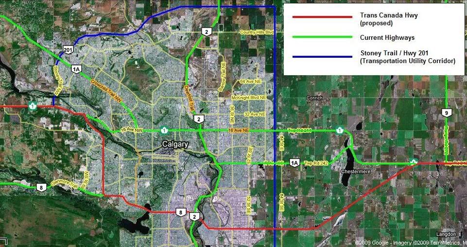
One other segment, although its not officially designated as TCH (yet), that will make a major difference to the overall system is the ring road around Calgary. The northern part should be complete late next year, allowing for traffic to loop around the north side of the city instead of having to go through the city, part of which is a 50km/h undivided road. I wouldn't be surprised if the ring road (highway 201) is added once its done, similar to how highway 100 around the south side of Winnipeg was given TCH designation.
The city of Calgary has made some improvements to 16 Ave, including widening a 16 block section from 4 lanes undivided to 6 lanes with a centre median - the main issue is there are still 26 signalized interesections through Calgary. While Stoney Trail (Hwy 201) will provide a bypass route, unlike Winnipeg there is a signifant increase in driving distance which may eliminate any time savings when going through the city.

Consider that in Winnipeg the distance between the TCH 1/100 east & west junctions is 30 km via TCH 1 and 40 km via TCH 100 (bypass route) - the bypass is an extra 10 km however it is still a faster route.

Now consider that in Calgary the distance between TCH 1/201 east & west junctions is 22 km via TCH 1 (16 Avenue) and approx 40 km via Hwy 201 (bypass route when complete) - the bypass is almost double the length through the city. Even if there is a small time savings, the average driver will see the significant extra distance and likely stick to 16 Ave.

The Trans Canada Highway should still go through Calgary, as opposed to around Calgary, so what I propose is to reroute Hwy 1 through Calgary via Sarcee & Glenmore Trails which are existing expressways through the city. While there are still 11 signalized intersections, sufficient ROW exists to replace all of them with interchanges. Extend the Glenmore Trail freeway east of Calgary and construct a NE/SW connector to reconnect with the current TCH east of Chestermere.

If a Glenmore extension was constructed, approx distances between Stoney Trail W & Hwy 9 (further east of the city) would be:
- 42 km via 16 Avenue N
- 49 km via Glenmore Trail/Sarcee Trail (approx, depending on alignment)
- 60 km via Stoney Trail

I've attached a map for your reference.


Any thoughts?
Reply With Quote
     
     
  #71  
Old Posted Feb 7, 2009, 10:37 PM
0773|=\ 0773|=\ is offline
Registered User
 
Join Date: Mar 2007
Posts: 1,256
^

I'd keep it running east of the highway and have it meet up further east of the city, much the same way Edmonton's Yellowhead does west of the city. I don't see the point of jogging so far north. Tie it in with a Strathmore bypass and you'd be in much better shape.
Reply With Quote
     
     
  #72  
Old Posted Feb 8, 2009, 1:13 AM
dmuzika dmuzika is offline
Registered User
 
Join Date: Feb 2006
Posts: 423
Quote:
Originally Posted by 0773|=\ View Post
^

I'd keep it running east of the highway and have it meet up further east of the city, much the same way Edmonton's Yellowhead does west of the city. I don't see the point of jogging so far north. Tie it in with a Strathmore bypass and you'd be in much better shape.
I've thought of that, maybe tieing it in with Hwy 901, the only thing is the eastern Calgary approach has the lowest traffic count of the 4 major entrances - it would be a tough sell to build a new freeway that stretches east of Strathmore.

An alternative could be a seperate Strathmore bypass, simlar to the bypasses around Vegreville or Portage La Prairie.
Reply With Quote
     
     
  #73  
Old Posted Feb 8, 2009, 4:35 AM
mersar's Avatar
mersar mersar is offline
Registered User
 
Join Date: May 2006
Location: Calgary, AB
Posts: 10,083
In terms of using Glenmore/Sarcee, I'd agree with using Glenmore however I'd suggest skipping Sarcee and just running the extra ~3km west along Glenmore/Highway 8 to where Stoney will intersect with it and then go north on Stoney to get back to #1. By the time that portion of #201 is fully built there will probably only be a half dozen signalized intersections left (52nd, Barlow, 37th and Sarcee at a minimum should hopefully be gone).

And yeah, I can't see a bypass around Strathmore then does more then just bypass Strathmore... its a pretty significant distance outside the city.
__________________

Live or work in the Beltline? Check out the Official Beltline web site here
Reply With Quote
     
     
  #74  
Old Posted Feb 8, 2009, 5:44 AM
manny_santos's Avatar
manny_santos manny_santos is offline
Registered User
 
Join Date: Jul 2006
Location: New Westminster
Posts: 4,990
Between Thunder Bay and Sault Ste. Marie, I doubt the TCH will ever be twinned. It's not needed either. If there are accidents, that's not the fault of the highway, it's the fault of bad drivers.
Reply With Quote
     
     
  #75  
Old Posted Feb 8, 2009, 6:34 AM
Spocket's Avatar
Spocket Spocket is offline
Back from the dead
 
Join Date: Feb 2006
Location: Edmonton
Posts: 3,503
Quote:
Originally Posted by manny_santos View Post
Between Thunder Bay and Sault Ste. Marie, I doubt the TCH will ever be twinned. It's not needed either. If there are accidents, that's not the fault of the highway, it's the fault of bad drivers.
Fair enough but dead people don't really care who's at fault. Anybody who's ever driven that stretch of the TCH will attest to the fact that about the only safe way to travel on it is to not. Maybe not twinned but a center barrier wouldn't be a bad idea in many spots. The problem is that there are very few straightaways so the only way to pass somebody is to wait until it's safe ("Next safe place to pass : 50 kms") or play pole position. 50 slow moving semis will convince anybody that "it's just a little risk...".
__________________
Giving you a reason to drink and drive since 1975.
Reply With Quote
     
     
  #76  
Old Posted Feb 8, 2009, 6:49 PM
vid's Avatar
vid vid is offline
I am a typical
 
Join Date: Apr 2004
Location: Thunder Bay
Posts: 41,172
Quote:
Originally Posted by Andy6 View Post
Northern Ontario was solidly Conservative at the provincial level for generations, during 40 years of PC governments, and it didn't seem to do much good in terms of highways. I remember when John Rhodes was the Tory MPP for the Sault and the Transportation minister we got the short four-lane stretch built through the Bar River Flats east of the Sault but it took another 30+ years to get the portion from the Sault to Echo Bay (nearly) completed. This is really essential for the economic development of Northern Ontario and especially for tourism. I could even see Manitoba and the Lake Winnipeg beaches developing as a destination for Torontonians on summer vacations if they could be assured of a safe drive across northern Ontario. People routinely drive to PEI for the same thing and would go the other direction for a change if the driving were equally easy.
Well, North Eastern Ontario might have been solidly Conservative, but Northwestern Ontario elect it's first conservative to any upper level of government for the first time in 75 years last October. Thunder Bay hasn't elected a Conservative since the days of R. B. Bennett. I don't think we've ever been represented by a Conservative in the Ontario legislature. Most of the Thunder Bay Expressway was built under Bill Davis's minority in the mid 1970s, and partly twinned under Rae. Other than that, this region gets little support for highways. Most of our road infrastructure only exists because corporations wanted to cut down trees.

They won't even add rumble strips. We tried asking for that and they aren't doing it. Just a couple years ago, the Thunder Bay Expressway got this fantastic new technology called "Cat's Eyes". Now you can see the centre line at night! Still no dividers though. How many more transports have to cross all four lanes and wipe out other drivers before they do something?

The reason there aren't as many people going through the north shore drive is because it's so dangerous. Trans-Canada freight traffic goes through the US.
Reply With Quote
     
     
  #77  
Old Posted Feb 8, 2009, 7:40 PM
Andy6's Avatar
Andy6 Andy6 is offline
Starring as himself
 
Join Date: Mar 2002
Location: Toronto Yorkville
Posts: 9,739
Quote:
Originally Posted by vid View Post
Well, North Eastern Ontario might have been solidly Conservative, but Northwestern Ontario elect it's first conservative to any upper level of government for the first time in 75 years last October. Thunder Bay hasn't elected a Conservative since the days of R. B. Bennett. I don't think we've ever been represented by a Conservative in the Ontario legislature.
I think you'll find you're mistaken. The PCs almost always held Fort William. The more working class Port Arthur riding tended to be CCF and NDP, I think, and was represented by Jim Foulds for a long time. Kenora was represented by Leo Bernier, who was more or less the Premier of Northern Ontario during the Davis years. The Liberals replaced the PCs as the opponents of the NDP in Northern Ontario at the end of the Davis era. Previously, the Liberals were non-entities in Northern Ontario provincially almost to the extent the PCs were federally.
__________________
crispy crunchy light and snappy
Reply With Quote
     
     
  #78  
Old Posted Feb 8, 2009, 8:00 PM
vid's Avatar
vid vid is offline
I am a typical
 
Join Date: Apr 2004
Location: Thunder Bay
Posts: 41,172
It doesn't change the fact that our road infrastructure is worse than Zimbabwe's.
Reply With Quote
     
     
  #79  
Old Posted Feb 8, 2009, 8:42 PM
Andy6's Avatar
Andy6 Andy6 is offline
Starring as himself
 
Join Date: Mar 2002
Location: Toronto Yorkville
Posts: 9,739
Quote:
Originally Posted by vid View Post
It doesn't change the fact that our road infrastructure is worse than Zimbabwe's.
No. It is not that important. I agree that the one major highway across the country should be in much better condition, especially given the boost it would give to a region that isn't doing well economically.
__________________
crispy crunchy light and snappy
Reply With Quote
     
     
  #80  
Old Posted Feb 10, 2009, 5:10 PM
Beltliner's Avatar
Beltliner Beltliner is offline
Unsafe at Any Speed
 
Join Date: Mar 2006
Posts: 949
Quote:
Originally Posted by dmuzika View Post
If a Glenmore extension was constructed, approx distances between Stoney Trail W & Hwy 9 (further east of the city) would be:
- 42 km via 16 Avenue N
- 49 km via Glenmore Trail/Sarcee Trail (approx, depending on alignment)
- 60 km via Stoney Trail

I've attached a map for your reference.


Any thoughts?
If I had to lay money on the outcome of a Glenmore Trail east extension, I would account for the following factors:
  • 17 Avenue SE to Chestermere would more than likely be stripped of its AB-1A designation in favour of an upgraded Peigan Trail;
  • Farm, residential acreage, and industrial landowners in the AB-1/Peigan/Glenmore corridors might have a thing or two to say about a straight-line spur connecting AB-1 to AB-8, and would more likely strongly suggest an alignment hewing more closely to the township and range road allowances already in place;
  • AB-1 between AB-2 and AB-201 will be upgraded to full motorway standards sooner rather than later;
  • ABDoT and Calgary Roads possess a multitude of tools that would make life more than miserable for any non-local or non-tourist driver tempted to drive through the city on AB-1 instead of diverting to AB-201;
  • The Glenmore Causeway is a flat-out, full-stop, no-go zone for dangerous goods traffic in the first instance, and a constant bottleneck due to rush-hour commuter traffic in the second instance; and
  • The individual segments of AB-1 through Calgary fulfil very different local roles than the one-size-fits-most way of thinking that informed the last round of plans for a Transcanada Motorway back in 1970.

In short, I would expect Peigan and Glenmore to tie into a northish-southish spur of the Transcanada, but not the full-on diversion to Glenmore.
__________________
Now waste even more time! @Beltliner403 on Twitter!

Always pleased to serve my growing clientele.
Reply With Quote
     
     
This discussion thread continues

Use the page links to the lower-right to go to the next page for additional posts
 
 
Reply

Go Back   SkyscraperPage Forum > Regional Sections > Canada
Forum Jump


Thread Tools
Display Modes

Forum Jump


All times are GMT. The time now is 7:24 AM.

     
SkyscraperPage.com - Archive - Privacy Statement - Top

Powered by vBulletin® Version 3.8.7
Copyright ©2000 - 2024, vBulletin Solutions, Inc.