HomeDiagramsDatabaseMapsForum About
     

Go Back   SkyscraperPage Forum > Regional Sections > Canada > Alberta & British Columbia > Calgary > Transportation & Infrastructure


Reply

 
Thread Tools Display Modes
     
     
  #41  
Old Posted Nov 3, 2009, 8:05 PM
bookermorgan's Avatar
bookermorgan bookermorgan is offline
Registered User
 
Join Date: Oct 2009
Location: Calgary
Posts: 289
although TCH is a bit off topic....

I live in Montgomery, and agree with the TCH needing to be fixed through there. there are too many cars and too many pedestrians. Im not too sure there would be any room on the opposite side of the river though. i think its a pretty steep hill there.

I am also glad that the Shouldice Park sports fields are there and not the previously highway interchange.

Guess im on the fence
Reply With Quote
     
     
  #42  
Old Posted Nov 3, 2009, 8:15 PM
Oliver Klozov Oliver Klozov is offline
Registered User
 
Join Date: Dec 2008
Posts: 224
Quote:
Originally Posted by YYCguys View Post
^Or perhaps, moving from east to west, let the TCH dip southward over the Bow River at Shaganappi and hug the CPR line and hook up to the original alignment at Bowdale Cres.
I think that is the only reasonable solution except that I don't think it could "hug the CPR" along the river. I would think they could go over the CPR with the river crossing and then parallel the tracks at a higher elevation with a new interchange when it crosses Sarcee. That would certainly require some hefty dollars for bank stabilization but that would probably be far less than all the expropriation required for any routing through Montgomery and far less disruptive as well.
Reply With Quote
     
     
  #43  
Old Posted Nov 3, 2009, 9:18 PM
jsbertram jsbertram is offline
Registered User
 
Join Date: Sep 2009
Posts: 3,245
Quote:
Originally Posted by Joborule View Post
I wonder if it would be possible to tunnel 16th ave between Deerfoot and Crowchild so you have the workings of making the TCH a full freeway while keeping a urban corridor on the ground above?
I recall in the late 70s there was a tunnel proposal for TCH, and it was part of a package to remove the CPR tracks from downtown.

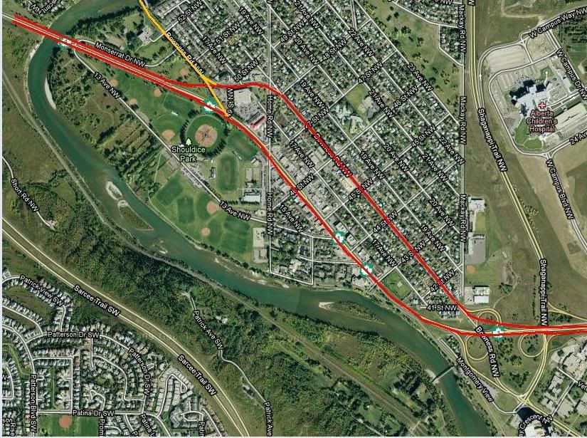
a) New CPR mainline tunnel mostly under 24th Avenue. Dual tracks in one tunnel or single tracks in two tunnels. East portal at Nose Creek. West Portal near Shouldice Park.

b) New "TCH Bypass" tunnel under 16th Ave. 3 lanes each direction with an EB main tunnel and a WB main tunnel. West portal between Shaganappi and Foothills Hospital. East Portal near Nose Creek / Deerfoot / CPR line at 16th Ave. Intersections would be the usual subjects: University Dr/Crowchild Tr, 14 st NW, 10 St NW, 4 St NW, Centre St, Edmonton Tr NE, 6 St NE.

The left-most lane in the tunnel was the 'express lane' from portal to portal. The right-most lane was essentially for on-ramps & off-ramps at the intersections. Because everything was underground, there would be full "fly overs" (fly unders?) connecting the intersected streets with the TCH tunnels. Its interesting to note that only North bound and South bound traffic at the streets intersecting 16th Ave would have access to the TCH tunnel, and traffic exiting the TCH tunnel would be directed only North and South on those streets. These entrance/exit ramps were actually 3 or 4 blocks away from 16th Ave.

The concept was to separate the traffic that wanted to bypass 16th Ave from the local area traffic. The on-street intersections along 16th Ave wouldn't have changed much: traffic lights for each direction, with some advance left-turn lanes. Perhaps some widening for right-turn lanes too.

ie: leaving downtown after work & taking Center street bridge, use the off-ramp at 12th Ave and head west in the tunnel. Take the Crowchild exit & leave the tunnel via the exit ramp north of 24th Ave. Continue my merry commute to Silver Springs.

ie: a trucker coming from Banff can take the TCH tunnel it's full length & turn up Deerfoot to get to the industrial park.

c) with the CPR line removed from downtown, redevelop the entire right-of-way as 4-lane freeway from Crowchild Tr / Bow Tr in the west to Blackfoot Tr / 17th Ave SE / Deerfoot Tr in the east. This cross-downtown freeway would have the typical diamond intersections with the major N-S streets. A Parkdale Blvd. -type of road along the south side of the Bow River would run West of Crowchild Tr / Bow Tr and connect with Shaganappi at Edworthy Park, and TCH & Sarcee in Bowness.

Pretty ambitious, but the Feds at the time were willing to cough up the cash - until Trudeau got defeated. No Liberals in power (nor Liberal Calgarians in Cabinet) - no more expensive infrastructure projects.
Reply With Quote
     
     
  #44  
Old Posted Nov 4, 2009, 12:24 AM
YYCguys YYCguys is online now
Registered User
 
Join Date: Sep 2006
Posts: 2,521
I apologize for perpetuating a topic so far off topic from the intent of the original thread. Moderator, perhaps, we could merge this thread with the thread titled "Calgary Roads"?
Reply With Quote
     
     
  #45  
Old Posted Nov 4, 2009, 6:07 AM
dmuzika dmuzika is offline
Registered User
 
Join Date: Feb 2006
Posts: 423
Quote:
Originally Posted by YYCguys View Post
I apologize for perpetuating a topic so far off topic from the intent of the original thread. Moderator, perhaps, we could merge this thread with the thread titled "Calgary Roads"?
The Trans Canada Hwy through Calgary as well as John Laurie/McKnight are somewhat related as they both deal with E-W cross-town routes (or lack there of) in north Calgary. The topic has garnered considerable response and it might be lost if merged with the "Calgary Roads" super thread.

Saying that, I’ll take my stab at the problem:

The fact is that the Trans Canada through north Calgary is unacceptable in its current state, even with the opening of Stoney Trail. For my own personal information, I want to drive 16 Ave N and Stoney Trail from the east to west interchanges to compare time & land distances – I suspect taking the ring road is no time savings because of the additional distance.

McKnight & John Laurie can be developed into a good inner city E-W cross-town route, but because JLB takes off in a NW direction it isn’t a good route to connect with the Trans Canada Hwy to go to Banff without adding significant distance.

What I think should happen is Glenmore Trail should be extended east of Calgary and link with Highway 1 somewhere near the Highway 9 junction – Glenmore Trail has the appropriate right of way to be a full freeway in its entirety. The Trans Canada Highway could then be rerouted along Glenmore & Sarcee Trails through Calgary. Here’s the approximate distances from Hwy 1/9 Jct. to the west Stoney Trail interchange:

16 Avenue N (current alignment): 42 km
Glenmore & Sarcee (proposed): 49 km
Stoney Trail: 60 km

The city could then shift their focus to McKnight & John Laurie as the main E-W inner city cross-town route, with the possibility of upgrading Shaganappi Trail between Crowchild & John Laurie so traffic that goes further west would use Crowchild.
Reply With Quote
     
     
  #46  
Old Posted Nov 4, 2009, 6:14 AM
dmuzika dmuzika is offline
Registered User
 
Join Date: Feb 2006
Posts: 423
Quote:
Originally Posted by bookermorgan View Post
although TCH is a bit off topic....

I live in Montgomery, and agree with the TCH needing to be fixed through there. there are too many cars and too many pedestrians. Im not too sure there would be any room on the opposite side of the river though. i think its a pretty steep hill there.

I am also glad that the Shouldice Park sports fields are there and not the previously highway interchange.

Guess im on the fence
I always thought a possible solution is to convert Bowness Rd to one-way westbound (possibly renaming the section as 18 Ave NW) while 16 Ave would be one-way eastbound. As much as it would pain me to say this, replacing the pedestrian crosswalk at 44 St NW with a regular set of signals would also slow down traffic.
Reply With Quote
     
     
  #47  
Old Posted Nov 4, 2009, 3:48 PM
bookermorgan's Avatar
bookermorgan bookermorgan is offline
Registered User
 
Join Date: Oct 2009
Location: Calgary
Posts: 289
Quote:
Originally Posted by YYCguys View Post
I apologize for perpetuating a topic so far off topic from the intent of the original thread. Moderator, perhaps, we could merge this thread with the thread titled "Calgary Roads"?
Can we merge it into the previous TCH Thread?
Here

Quote:
Originally Posted by dmuzika View Post
I always thought a possible solution is to convert Bowness Rd to one-way westbound (possibly renaming the section as 18 Ave NW) while 16 Ave would be one-way eastbound. As much as it would pain me to say this, replacing the pedestrian crosswalk at 44 St NW with a regular set of signals would also slow down traffic.
Seems like an option, although there is a lot of housing along there.

Last edited by bookermorgan; Nov 4, 2009 at 4:10 PM.
Reply With Quote
     
     
  #48  
Old Posted Nov 4, 2009, 4:15 PM
SubwayRev's Avatar
SubwayRev SubwayRev is offline
Registered User
 
Join Date: Aug 2007
Location: Calgary
Posts: 445
Quote:
Originally Posted by dmuzika View Post
The Trans Canada Hwy through Calgary as well as John Laurie/McKnight are somewhat related as they both deal with E-W cross-town routes (or lack there of) in north Calgary. The topic has garnered considerable response and it might be lost if merged with the "Calgary Roads" super thread.

Saying that, I’ll take my stab at the problem:

The fact is that the Trans Canada through north Calgary is unacceptable in its current state, even with the opening of Stoney Trail. For my own personal information, I want to drive 16 Ave N and Stoney Trail from the east to west interchanges to compare time & land distances – I suspect taking the ring road is no time savings because of the additional distance.
...
I drove Stoney from 16th/Sarcee NW to Stoney/16th NE, and it was 44km and 27min. Then, I returned along 16th Ave, and it was 17km and 26min.
Reply With Quote
     
     
  #49  
Old Posted Nov 4, 2009, 4:21 PM
bookermorgan's Avatar
bookermorgan bookermorgan is offline
Registered User
 
Join Date: Oct 2009
Location: Calgary
Posts: 289
i guessing better gas mileage though? not as much idling and accelerating
Reply With Quote
     
     
  #50  
Old Posted Nov 4, 2009, 4:21 PM
You Need A Thneed's Avatar
You Need A Thneed You Need A Thneed is offline
Construction Enthusiast
 
Join Date: Feb 2007
Location: Castleridge, NE Calgary
Posts: 5,892
Quote:
Originally Posted by SubwayRev View Post
I drove Stoney from 16th/Sarcee NW to Stoney/16th NE, and it was 44km and 27min. Then, I returned along 16th Ave, and it was 17km and 26min.
So, using those numbers, we could extrapolate that from Stoney/16th NW to Stoney 16th NE, would be about 24-25 minutes along Stoney Trail, and 28-29 across on 16th Ave.

So the ring road would save about 5 minutes, even at the best of times. 16th Ave will be more prone to rush hour delays, too, for the most part.
Reply With Quote
     
     
  #51  
Old Posted Nov 4, 2009, 7:01 PM
YYCguys YYCguys is online now
Registered User
 
Join Date: Sep 2006
Posts: 2,521
Quote:
Originally Posted by bookermorgan View Post
Seems like an option, although there is a lot of housing along there.
It looks like a simple enough solution and would make it easier for traffic, I think, opening up lanes for turning. Would there need to be any modifications to interchanges or intersections in that section, specifically where the east and west portions of Bowness Road intersect with this newly realigned TCH?
Reply With Quote
     
     
  #52  
Old Posted Nov 4, 2009, 7:14 PM
lubicon's Avatar
lubicon lubicon is offline
Suburban dweller
 
Join Date: Jun 2003
Location: Calgary - our road planners are as bad as yours Edmonton
Posts: 5,047
Quote:
Originally Posted by YYCguys View Post
It looks like a simple enough solution and would make it easier for traffic, I think, opening up lanes for turning. Would there need to be any modifications to interchanges or intersections in that section, specifically where the east and west portions of Bowness Road intersect with this newly realigned TCH?
East:
Would be fairly simple, but the bridge structure where Bowness Road passes underneath 16 Ave might need to be modified. The EB routing would stay pretty much the same. WB lanes would need to be rerouted off 16 Ave and onto Bowness Road. All in all it looks faily simple.

West:
A lot more complicated. Currently there is a small connector road between 16 Ave and Bowness Road, jsut west of the Safeway. There is a small strip mall on the west side of this road that would need to be demolished to make way for the WB lanes. As well some of the park that sits jsut west of this strip mall might have to go. The biggest snag would be where Bowness Road would split off again from the TCH. Thre needs to be a way for traffic coming along EB Bowness Road to get over to the EB lanes of the TCH, and that involves somehow crossing the WB lanes of the new TCH alignment.
__________________
Two things are infinite: the universe and human stupidity; and I'm not sure about the the universe.

Albert Einstein
Reply With Quote
     
     
  #53  
Old Posted Nov 4, 2009, 7:39 PM
mersar's Avatar
mersar mersar is offline
Registered User
 
Join Date: May 2006
Location: Calgary, AB
Posts: 10,083
If the strip mall there where DQ is goes then you could probably build a small flyover bridge to connect EB Bowness to EB 16th. Depending on how gradual of curves are used it may be possible to do without needing to take too much of the park for it as well.
__________________

Live or work in the Beltline? Check out the Official Beltline web site here
Reply With Quote
     
     
  #54  
Old Posted Nov 4, 2009, 8:01 PM
You Need A Thneed's Avatar
You Need A Thneed You Need A Thneed is offline
Construction Enthusiast
 
Join Date: Feb 2007
Location: Castleridge, NE Calgary
Posts: 5,892
If they ever want to freeway-ize that section through montgomery, they are going to want to twin the Bow river bridge as well, for a little bit of extra cost, build a new bridge across the river close to where Bowness Road crosses 16th Ave, and somehow fit the new road on the south bank of the river, even if that means stacking the highway on top of the train tracks. Then it would connect up with the existing alignment about where Sarcee intersects 16th Ave.

The sarcee interchange is old and too narrow, and would need to be replaced anyway. Also, an alignment like that solves the issue of the train bridge over 16th being too narrow as well.

You also don't have to bulldoze one of the only streets in the city that still feels like the main street of a smaller town.
Reply With Quote
     
     
  #55  
Old Posted Nov 4, 2009, 8:03 PM
jsbertram jsbertram is offline
Registered User
 
Join Date: Sep 2009
Posts: 3,245
I remember there was another proposal for 16th Ave expansion that stretched from Crowhild Tr. (Motel Village) in the west to Deerfoot Tr. in the east. All the properties on the north side of 16th Ave and south side of 17th Ave would be expropriated, and the entire stretch turned into a grand boulevard across the north side. There would be enough room for 16th Ave to be four lanes eastbound and 17th Ave four lanes westbound (plus extra width for left-turn and right-turn lanes). No fancy Diamond interchanges & fly-overs either, just properly-timed lights to keep the traffic flowing.

Oh yes ... a row of trees down the median to make it look pretty.

It seems the planners wern't expecting too much NIMBYism, but the impending destruction of the pre-WW1 sandstone school (I think it's Balmoral Elementary) at 16th Ave & 2nd St was the catalyst for every neighbourhood along that path to fight for their survival.

The result was 25 more years of meetings and planning, with the ultimate compromise of a strip of properties on the south edge of 16th getting removed for 16th Ave to be widened.

I'm happy to see that Peter's Drive-In may have had part of their picnic area along 16th lopped off, but they are still there! Iwanna Dubble Cheese with everything ana Straberry Shake, please!
Reply With Quote
     
     
  #56  
Old Posted Nov 4, 2009, 8:54 PM
dmuzika dmuzika is offline
Registered User
 
Join Date: Feb 2006
Posts: 423
Quote:
Originally Posted by mersar View Post
If the strip mall there where DQ is goes then you could probably build a small flyover bridge to connect EB Bowness to EB 16th. Depending on how gradual of curves are used it may be possible to do without needing to take too much of the park for it as well.
If it's two parellel one-way streets, EB Bowness could simply intersect WB TCH and merge into EB 16 Ave. That would also allow for a U-turn route for WB TCH to access EB 16 Ave businesses.

Reply With Quote
     
     
  #57  
Old Posted Nov 4, 2009, 9:05 PM
Oliver Klozov Oliver Klozov is offline
Registered User
 
Join Date: Dec 2008
Posts: 224
Quote:
Originally Posted by You Need A Thneed View Post
If they ever want to freeway-ize that section through montgomery, they are going to want to twin the Bow river bridge as well, for a little bit of extra cost, build a new bridge across the river close to where Bowness Road crosses 16th Ave, and somehow fit the new road on the south bank of the river, even if that means stacking the highway on top of the train tracks. Then it would connect up with the existing alignment about where Sarcee intersects 16th Ave.

The sarcee interchange is old and too narrow, and would need to be replaced anyway. Also, an alignment like that solves the issue of the train bridge over 16th being too narrow as well.

You also don't have to bulldoze one of the only streets in the city that still feels like the main street of a smaller town.
Okay, now that's 3 guys with basically the same idea -

The cops sure wouldn't like the idea though; they would lose one of their best spots for filling their monthly speeding ticket quota in an afternoon!

And to add something ........

move 16th northward a bit, build a new bridge(s) at Shaganappi for 16th and have an interchange with moves possible in all directions. Move Bowness over to the old 16th from 41 St to west of Home, have new 16th flyover only and take out the old Bowness under 16th.
Reply With Quote
     
     
  #58  
Old Posted Nov 5, 2009, 12:50 AM
craner's Avatar
craner craner is offline
Go Tall or Go Home
 
Join Date: Mar 2007
Location: Calgary
Posts: 6,757
Quote:
Originally Posted by dmuzika View Post
The city could then shift their focus to McKnight & John Laurie as the main E-W inner city cross-town route, with the possibility of upgrading Shaganappi Trail between Crowchild & John Laurie so traffic that goes further west would use Crowchild.
Good point - this has been on my mind as well if JLB was upgraded. The interchange at Crow-Shag. would need to be upgraded as well to be free flow.
Another option would be to use Sarcee to connect JLB and Crow.
Reply With Quote
     
     
  #59  
Old Posted Apr 18, 2012, 9:50 PM
mersar's Avatar
mersar mersar is offline
Registered User
 
Join Date: May 2006
Location: Calgary, AB
Posts: 10,083
I usually get mad at people for reviving long dead threads, so here I go doing it myself

Heard a rumor recently that the city is looking at new options to addressing the McKnight/John Laurie corner. Supposedly one of the things on the table is extending McKnight through North Haven along 48th Avenue to 14th Street. Not quite sure how this will help beyond traffic heading north from JLB to 14th Street though.
__________________

Live or work in the Beltline? Check out the Official Beltline web site here
Reply With Quote
     
     
  #60  
Old Posted Apr 18, 2012, 11:22 PM
jsbertram jsbertram is offline
Registered User
 
Join Date: Sep 2009
Posts: 3,245
48th Ave west of JLB/ McKnight was built as a suburban street, so you'll have some difficulty widening the street without having to take some homes.

Meanwhile, JLB north of McKnight was supposed to run in what is now Egerts Park. There's nothing stopping the city from changing the park to road for the JLB extension connecting to 14th St near 64th Ave (although two T intersections so close together on 14th St would be an issue).

Now which battle is easier to win?
a) Expropriating homes for 48th Ave widening;
b) Converting a park into a Boulevard

Either way, the JLB/ McKnight intersection will also have to be upgraded, since there would be new traffic streams from the West or North that will be going through or turning to continue traveling on the existing JLB or McKnight boulevards


I think this is an obfuscation exercise by someone, and the real answer continues to be the purchase of the three or four properties closest to the corner of Hendon Dr and Holland St so the homes can be demolished and the JLB/ McKnight intersection rebuilt to smooth out the curve from JLB to McKnight.
Reply With Quote
     
     
This discussion thread continues

Use the page links to the lower-right to go to the next page for additional posts
 
 
Reply

Go Back   SkyscraperPage Forum > Regional Sections > Canada > Alberta & British Columbia > Calgary > Transportation & Infrastructure
Forum Jump


Forum Jump


All times are GMT. The time now is 3:21 PM.

     
SkyscraperPage.com - Archive - Privacy Statement - Top

Powered by vBulletin® Version 3.8.7
Copyright ©2000 - 2024, vBulletin Solutions, Inc.