Alexanderplatz a history of!
All info from the links below!
http://www.stadtentwicklung.berlin.d...te/index.shtml
History – myth and presence
Cut-out of a collage to the movie "Berlin – Symphonie einer Großstadt"

Alexanderplatz was one of the most famous metropolitan places of the "Golden Twenties" as described by Alfred Döblin in his novel "Berlin Alexanderplatz", by Walter Ruttmann´s the film "Berlin, Symphonie einer Großstadt" or displayed in the modern urban planning by Martin Wagner in the 1920s.
Over the years many changes have taken place at Alexanderplatz. Yet it remains an essential part of Berlin´s cultural history and holds its place on the "mental map" of the Berliners and their visitors alike.
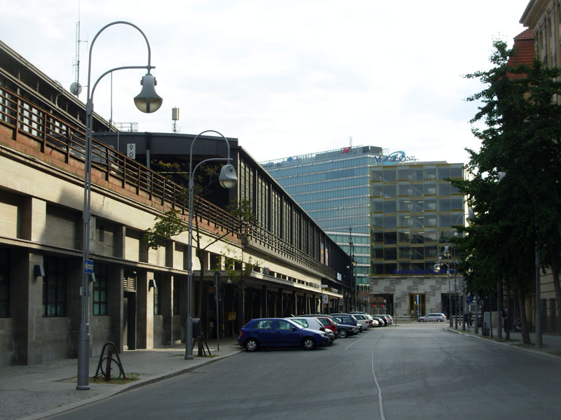
Transport hub in the 1930s

It is not only the myth of Alexanderplatz, so called since 1805, that made the square so famous. In fact, the zeitgeist of each time has left its traces on it in very tangible ways and turned the square into a place of bustling economic life, upturn and change par excellence.
Already when the city was founded in the 13th century an old trading route ended here, which linked the former hanseatic town of Berlin to the Baltic region. In the centuries after the city´s foundation the site of the later square emerged as an important marketplace that changed its names and goods alike. Most popular were the "Ochsenmarkt" (oxenmarket) – later called "Viehmarkt am Stelzenkrug" – the "Wollmarkt" (woolmarket) and the "Wochenmarkt" (weekly market).
In the 19th and early 20th century, with its modern public transport system and trainstation, hotels, department stores and office blocks – Alexanderplatz became one of the vibrant centres of the rapidly growing metropolis of Berlin
photo from the year 1968 showing the awarded scheme that was realized in large parts between the years 1967 and 1971

Alexanderplatz, 1973

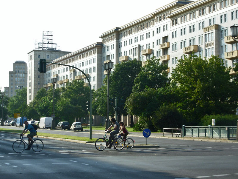
In the post-war decades, Alexanderplatz had retained its outstanding significance as the centre of the East German capital. But its physiognomy had dramatically changed. Due to the reconstruction programme based on the urban design paradigms of post-war modernism, it had acquired a physiognomy which was characterised by low-density development with plenty of open space and excessively wide traffic axes.
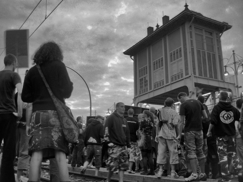
In November 1989, Alexanderplatz was to become the arena for a peaceful revolution. On November 4th, nearly one million people gathered in a political demonstration demanding freedom of the press, freedom of opinion and the right of free assembly.
demonstration at Alexanderplatz, November 4th, 1989

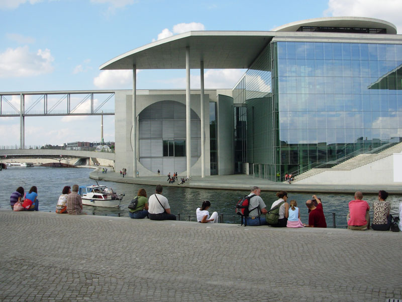
With reunification in 1990, Alexanderplatz as one of the most important central sites in Berlin with its huge potential of areas to be developed - along with Potsdamer/Leipziger Platz and Breitscheidplatz/Bahnhof Zoo - moved once again to centre stage in the debates over increasing density in the traditionally polycentric inner city. Out of these debates and as a result of the "International competition for urban design ideas – Alexanderplatz" in 1993, a new urban design-concept was finally developed for Alexanderplatz. Since 2000, the first two (out of four) binding land-use plans "I-B4a - Alexanderplatz" and "I-B4d - Shopping Mall Alexanderstraße" have been constituted and are about to be realized.
Königskolonnaden at the Alexanderplatz.
All info from the links below!
http://www.stadtentwicklung.berlin.d...0/seite3.shtml
From city founding to the capital of the German Reich
The various names of Alexanderplatz
Until the beginning of the 17th century the area of the later Alexanderplatz was an unhabitated place outside the city walls near to the Oderberger Tor in the Northeast of Berlin, used for pasture and agriculture. Nearby the spital and chapel of St. Georg were located. For that reason the Oderberger Tor was soon renamed into Georgentor and the growing suburb named Georgenvorstadt. In 1701 already up to 600 houses formed part of the Georgenvorstadt. In the same year the district was ennobled and renamed into "Königsvorstadt" (royal suburb), as Friedrich III., the Elector of Brandenburg, had become "King of Prussia" in the cathedral of Königsberg and then processed as "King Friedrich I" through Georgenvorstadt and Georgentor into the city of Berlin. From then on, the suburb was called "Königsvorstadt", the moat was called "Königsgraben", the gate "Königstor" and the central street leading to the Berliner Schloss was renamed into "Königsstraße".
Only in 1805 the square got the name it still bears today "Alexanderplatz" in rememberance of the state visit by Czar Alexander I of Russia. A royal cabinet decree was issued on November 2nd 1805, officially providing for the place in front of "Königstor" its present name. Czar Alexander I had been received on the parade ground in front of the Königstor and from there a ceremonious procession led into the capital and to the royal seat. Accordingly, in the year 1810, the street which met Alexanderplatz in north-south-direction, was renamed into "Alexanderstraße". Before that event the northern part of the street had been called "Auf der Contre Escarpe" and the southern part to the river Spree was called "An der Contre Escarpe". "Contre Escarpe" or "Contrescarpe" was an old French term for "a pulled forward mound in front of the moat at the city walls". Thus the street that followed this mound outside the city walls was consequently called "on" or "at" the mound. Later on the northern part was renamed into "Memhardstraße" in honour of Johan Gregor Memhard, the fortifications´ architect of Elector Friedrich Wilhelm. The southern part is still called Alexanderstraße and because of the high international reputation of Alexanderplatz and Alexanderstraße also the new shopping centre at Alexanderstraße will bear the meaningful name "ALEXA".
1237 – 1871
Berlin had been founded in 1237 as the twin settlements of Berlin and Cölln. In 1648, Johan Gregor Memhard as the fortifications´ architect of Elector Friedrich Wilhelm drew up the first map of Berlin, which was published in 1652 (the plan is aligned to the Northeast). The map shows the previous urban structure of the medieval city whose texture is still recognizable: the city walls formed a ring wall around the city (today the course of the Stadtbahn) with an exterior moat that was fed by the river Spree. The inner block-structure had been developed according to the limitations of the city walls as well as to the geographical and topographical givings of the site. Cölln was situated on the East bank of the river Spree, Berlin on the West bank and the twin settlements merged together forming one city. On the boggy northern half of the Spree-island located between the two settlements and officially belonging to the settlement of Cölln, the palace and gardens of the Hohenzollerns were situated.
The city plan shows typical features of the planned towns of the North from the 12th and 13th centuries. Similarly, Berlin was a Hansetown with a flourishing economy.
Already in Memhard´s city map the site of the later Alexanderplatz shows a certain potential for growth in respect to traffic and economical development: The site was located at an intersection between the medieval city and the rural areas that soon would clear the way for suburbs of the expanding city. Nearby were the city gate Georgentor – renamed into Königstor in 1701 – as well as the city walls with their moat that since 1882 determined the course of the elevated railways and became very important for commerce and for transport in the city.
Memhard´s map also shows that the early Alexanderplatz was already a traffic junction and an "eye of a needle" into the inner city. At the city gate Königtor the cross-country roads to Landsberg, Oderberg, Bernau and Prenzlau converged and - filtered through the gate - they were channelled into the city centre´s main street Königsstraße that runs as a broad axis past Berlin´s town hall onto Schlossplatz, the square in front of the palace. The Georgentor/Königstor had a special status among the Berlin-Cölln city gates. It was considered to be the economically most important city gate because, due to the importance of trade with the Baltic countries for the hanseatic city of Berlin, it saw the majority of commercial traffic thus gaining the bulk of excise duties.
In 1658, after the experience of the Thirty Years´ War (1618-1648) that had destroyed large parts of the twin city Berlin-Cölln, the ramshackly city walls were going to be replaced by modern fortifications. Memhard was comissioned by the Great Elector Friedrich Wilhelm to start overseeing the construction of the fortifications. They wind around the old corpus of the city, creating a formidable ring of fortifications with star-shaped bastions and curtains, broad walls and moats. Completed in 1683 this bastion actually did the city more harm than good. It hemmed it in like a tight corset, hampered its planned development and, above all, made radical cuts through the road network and into the link that had existed for centuries between the main streets of the city centre and the cross-country roads leading into the city. In addition, the fortifications were soon of little military use because already the new western districts Friedrich- and Dorotheenstadt as well as the suburbs in the East lay outside the fortifications.
The Georgen- / Königstor benefitted from the refurbishment of the fortifications while some of the other citygates had deteriorated or lost their functions entirely; the roads running through them had been ruthlessly truncated, others had been forced into complicated diversions. The former cross-country traffic through Stralauer Tor was now also routed through Georgentor / Königstor, and Berlin´s main street behind Georgentor was forced to carry extra functions.
The concentration of streets that had now become even more complex was absorbed in front of the city walls at Georgentor / Königstor by the spacious square that was the forerunner to Alexanderplatz. The square was divided into several functions: Near the city-entrance Georgentor / Königstor the place was used as a control point for customs clearance. The northern part of the place was used as a marketplace and cattle-market known as "Ochsenmarkt" (oxmarket). In the second half of the 17th century the importance bearing of the "Ochsenmarkt" grew to a certain extent when the Great Elector issued ordinances requiring a number of agricultural functions to be moved out of the city into the suburbs. Thus, in 1672, Berlins´s barns were relocated beyond the city walls into what later became known as "Scheunenviertel" (barn district) and the prohibition of keeping pigs within the city walls, issued in 1681, led to the development – described by Friedrich Nicolai in 1786 – of a "Viehmarkt am Stelzenkrug" (livestock market at Stelzenkrug), exactly at the point where Bernauer and Prenzlauer Straße converged – which would later become Alexanderplatz. In the second half of the 18th century the northern part of the later Alexanderplatz was also used as a wool market and until 1886, when new market halls were built nearby, a weekly market was held there.
The southern part of the later Alexanderplatz was called "Paradeplatz" because the site was used as a parade-ground by the military since the barracks "Exerzierhaus" had been built in 1799-1800.
Because of Berlin´s fast expansion in the 18th century Friedrich Wilhelm I. decided to build new city walls (1734-37) that also included the former suburban districts. The new city walls were called "Akzisemauer" (import-duty-wall) and were of little military use. Their prime purpose was to guarantee the imposure of import-duties (Akzise)(practised since 1667) and to prevent desertion. At that time the old inner city walls lost their function and were pulled down. The connection between Königsstraße and Königstor was renamed "Neue Königsstraße" (new royal street).
1866-69 also the "Akzisemauer" - with exception to the Brandenburg Gate being part of it - was completely pulled down.
Painting by Eduard Gärtner with view from "Königsgraben" (royal moat) onto "Königsbrücke" (royal bridge) and "Königskolonnaden"
(royal colonnades) by the architect Carl von Gontard. The street "Königstraße" (royal street) led to the "Schlossplatz" (site in front of the king´s mansion). In the background on the right (enlarged picture) there is the tower of St. Mary´s church.

Königstädter Theater" (on the left) and "Königskolonnaden"

At the beginning of the 18th century, the basic structure of Georgenvorstadt was firmly established. The irregular plan is a clear indication of the fact that it had developed spontaneously in the midst of the cross-country roads that converged here from different directions and in its difficult peripheral position in relation to the bastion of fortifications. Large factories - in particular silk and woolen mills - and military institutions established themselves here. Although buildings outside the city walls were not permitted officially, there was no chance to stop the expansion of the suburbs.
Gradually, the first architecturally important buildings began to emerge, including David Gilly´s famous Exerzierhaus (1799-1800) and Carl von Gontard´s Königstor-Kolonnaden (1777), which were a series of colonnaded shops built on the site of Georgentor / Königstor (demolished in 1746) forming a new stone bridge across the moat. Today the multiplex-cinema CUBIX is situated on the site of the former Königstor-Kolonnaden.
Additionally may be mentioned the architecturally less important Königstädter Theater, a very popular theatre in the mid 1820ies, which was built by the architect Karl Theodor Ottmer in 1824. Since 1851 the theatre was used as a storehouse for the woolmarket and later on as a dwelling house. The restaurant "Aschinger" in the ground-floor became very famous by Alfred Döblin´s novel "Berlin Alexanderplatz".
In 1805 "Platz vor dem Königstor" was renamed into "Alexanderplatz". It was at this time that the square in front of the gate also took on the shape it would retain until the early decades of the 20th century.
In spring 1813, after the failed campaign of the French emperor Napoleon against Russia, again Russian military crossed Alexanderplatz entering Berlin and expelling the French army.
At the beginning of the March Revolution in 1848 also Alexanderplatz witnessed some violent battles.
Due to the growing industrialization in the second half of the 19th century new factories were built and many people moved into the cities in search for new jobs. Cheap flats were needed in large numbers. Thus the density and height of the building-quarters on the eastern side of Alexanderplatz increased in a short period of time. Alexanderplatz developed more and more into the urban centre of the eastern boroughs.
All info from the link below!
http://www.stadtentwicklung.berlin.d...re/index.shtml
Panoramic view from the east onto Alexanderplatz, 1906. On the left the large building of the former police headquarters and the embellished parade ground. In the middle at the corner of Königstraße is located the former "Königstädter Theater" that was already conversed into a dwelling house with the tavern "Aschinger" on the ground floor. Behind the viaduct the "Königskolonnaden" that were relocated to "Kleistpark" in 1906. On the right - behind some buildings – there is the train station Alexanderplatz and to the far right the department store "Hertie".

View in eastern direction from Alexanderplatz onto the "Grand Hotel", 1894

Alexanderplatz
Development as a metropolis after the foundation of the German Reich in 1871
1871 - 1920
During the course of the 19th century, Königsvorstadt (formerly Georgenvorstadt) gradually acquired the density and appearance that it was characterised by until the large-scale destruction during the Second World War and the demolition of the post-war-years.
In line with the rapid succession of building codes, each one replacing its predecessor, mainly three-storey buildings grew up at the beginning of the 19th century, four-storey buildings in the mid-19th century and finally five-storey buildings in the latter half of the century. But it was not only the generally higher buildings but also the development of the land inside the blocks that increased the density of the area. Whilst the maps of the city in the mid-19th century show that large areas of Spandauer Vorstadt and Königsvorstadt, including land in the interior of the uninterrupted perimeter block developments, were still being used for gardens, later developments, particularly after the foundation of the German Reich in 1871, led to blocks being built on in their entirety, something which fifty years later would lead to Berlin being called "city of stone".
View in western direction over Alexanderplatz onto the city centre, 1896

View from the viaduct onto Alexanderplatz, 1903

Despite the rapid increase in density, which took place in the space of not even a hundred years, the basic street pattern of the city had been preserved; only the bastions were demolished and the land built on. But the range of uses changed quite considerably as the city centre began to crystallise. Military activities and the large industrial production locations, such as the textile mills, were gradually elbowed out. Attracted by the proximity to the city centre, a large number of commercial and service industries began to take their place and complement the commerce and light industry that had already existed in the courtyards within the blocks in Königsvorstadt.
The development of the area was boosted considerably when the Berlin Stadtbahn, or elevated railway, was built on the site of the moat that had been filled in and, in particular, when the station on this line opened in 1886 at Alexanderplatz.
After the moat had been filled the Königsbrücke was obsolete and was thus pulled down. Since then there is the subway crossing of the Berlin Stadtbahn connecting Alexanderplatz and Königstraße. The Königskolonnaden were located directly behind the subway crossing until they were translocated to another site.
Train station Alexanderplatz, 1882

In 1886 the new central market halls, situated on the western side of the Stadtbahn with direct connection to the railways, had been completed. Since then the open market on Alexanderplatz was abolished and re-housed in a central market hall. The rail connection allowed for trading throughout the continent and was within easy reach to many harbours. The cattle-market moved from "Ochsenmarkt" to the "Zentralviehhof" (central livestock market) between Frankfurter and Landsberger Allee.
In 1895, Alexanderplatz acquired its most striking landmark in the form of the colossal statue of Berolina. Emil Hunderieser had cast the 7,5 metre tall figure in bronze, and she occupied her first location on the small grassed area on the northwestern edge of Alexanderplatz in front of the 1904-05 built department store "Kaufhaus Hermann Tietz".
Statue "Berolina", 1896

In 1925 the statue had to be removed due to necessary diggings for the subway-stations underneath Alexanderplatz. In 1934 the Berolina was erected again in front of the Alexanderhaus until 1944 the statue was finally melted down for the arms production.
At the end of the 19th century the northern part of Alexanderplatz, where several lines of the horse-drawn tram system already criss-crossed, developed into an uban area predominantly characterised as a traffic hub; the southern part of the square (formerly known as Paradeplatz) developed around 1889 into an ornamental square with gardens.
In the decades around the turn of the century a number of buildings were built that gave the square additional functions and thus contributed to the development of Alexanderplatz in a metropolitan scale: the Grand Hotel (1883-84), the police headquarters and the local court building (both around 1886).
Alexanderplatz
Development as a metropolis after the foundation of the German Reich in 1871
Aerial picture, 1912. View from south onto Alexanderplatz with the statue "Berolina" in front of the department store "Tietz"

"Temple of consumerism" at Alexanderplatz
Department store "Tietz" before enhancement, 1905

Department store "Wertheim" at the corner Königstraße / Friedrichstraße

View into Königstraße with the department store "Wertheim". In the back Alexanderplatz and St. Georg´s church are to be seen.

Alexanderplatz reached the pinnacle of its commercial development when the great "temples of consumerism" were built at the beginning of the 20th century in the form of the Hahn, Wertheim, and Tietz department stores. The locational advantages offered by the modern transport hub for all kinds of commercial activities were finally realized. The construction of the legendary Tietz department store, from which the Hertie chain of store developed (the name being derived from HERmann TIEtz), set a dominant landmark on Alexanderplatz. Built within the course of 12 months, between 1904 and 1905 by the architects Cremer & Wolffenstein, the department store was located between Alexanderstraße (formerly Contrescarpe), Alexanderplatz and Am Königsgraben.
Two extensions to the modern building followed soon in rapid succession from 1907 until 1911. With its 250 metre frontage on Alexanderstraße it had the longest façade of any department store in the world.
In 1911 an other large department store namely Wertheim at Alexanderplatz opened in Königstraße on the opposite side of the Berlin Stadtbahn. The "Königskolonnaden" (engl.: King´s colonnades) had been formerly situated here, but in 1910 after long discussions, they were translocated to Kleistpark in Berlin-Schöneberg.
Aerial picture, 1920, showing the historic city centre with Alexanderplatz on the upper left (red coloured)

Development of the modern transport hub in the Weimar Republic
View from St. Georg´s church in western direction onto Alexanderplatz and Königstraße, around 1930

The growing transport hub
With its special transport situation, Alexanderplatz attracted hotels, restaurants, and cafes, theatres, cinemas, and department stores and developed within a few decades into an area that had the true character of a city centre. In the early years of the 20th century it gradually assumed functions in relation to the entire city, a development that reached its climax in the 1920s and 1930s.
Built to plans drawn up by J. Bousset (from 1913 onwards) and designed by Alfred Grenander (1927-31), the underground station at Alexanderplatz was conceived as a multilevel hub, that sought to separate and organise public transport in a way that was exemplary for its time, routing it on a total of five levels so that none of the lines crossed each other. The mainline and suburban railways were routed on elevated tracks, the three underground railway lines ran on three different levels below ground, and at ground level omnibusses and trams ran alongside private traffic which, at the time, still included the broadest range of vehicles – both motorised and non-motorised.
Alexanderplatz developed into one of the busiest transport hubs in Europe. The number of vehicles crossing Alexanderplatz increased from about 1.200 vehicles daily in 1918 to approximately 229.000 in 1939.
View from Alexanderplatz onto Königstraße, 1929

The shaping of a metropolitan square
Completely in line with the spirit of Modernism and a vision of the future that affirmed the new motor traffic as a sign of progress, Martin Wagner in his role as City Architect, attempted at the end of the 1920s to tackle the traffic problems of Alexanderplatz and at the same time to create an architecturally uniform square with spatial coherency. He was responsible for the very first project on which all subsequent planning schemes were based.
The layout of the square that was historically divided into several sections is abandoned in this scheme in favour of a horseshoe-shaped area on which Wagner placed a traffic island, which would take the traffic flow from the large number of roads and distribute it effectively. The grassy rondell in the centre of the square across which only tramlines were allowed to run, had a diameter of 100 metres.
In order to ensure that the new square would have an architectural coherency despite the total of six roads converging here, Wagner built a structure across the junction of Landsberger Allee and Königstraße level with the third storey of the surrounding seven-storey development.
Also Hermann Tietz as owner of the department store "Tietz" was willing to refurbish the façade of his building facing Alexanderplatz in order to adapt to the new design.
Model of the Alexanderplatz-planning by M. Wagner, 1929

Development of the modern transport hub in the Weimar Republic
The urban design competition of 1929
Wagner´s visionary schemes for Alexanderplatz as a magnificent project to organise the two difficult elements "space" and "traffic" had set the standards for a large-scale urban competition adjudicated in February 1929. Peter Behrens, Hans and Wassily Luckhardt with Alfons Anker, Paul Mebes, Ludwig Mies van der Rohe, Johann Emil Schaudt and – the only non-Berliner – the architect Müller-Erkelenz from Cologne were invited to take part in the competition.
Despite being awarded first prize, the practice of Luckhardt & Anker was not commissioned to carry out their scheme. The second prize winner Peter Behrens was appointed, instead. His design would cope better with the difficult foundation works due to the three existing levels of underground railway lines. But his scheme was also only partially completed due to the private ownership situation and the 20 million Reichsmark that would have been needed in order to purchase the plots.
The plan of Peter Behrens followed Martin Wagner´s original idea of the horseshoe-shaped perimeter block development. But all that had finally been built were the Alexanderhaus and the Berolinahaus in the years 1929-31. They were modern eight-storey steel-framed buildings - a revolutionary way of construction in those days. With the main volumes running parallel to the Stadtbahn railway and the ends of the buildings facing Königsstraße, they reflect the historical gateway situation of Königstor and were intended to form a linear termination to the horseshoe shape of the square.
Due to the difficult land ownership situation and in contrast to Martin Wagner´s original plan the square ultimately could not be built as a classical roundabout, a circle, but was built as an oval thereby loosing the relationship to the axes of the main roads as intended by Wagner.
With Landsberger Straße, Königstraße, Neue Königstraße, and the two sections of Alexanderstraße a total of five streams of traffic converged into the square. The grassy area in the centre of the traffic island was exclusively reserved for the tram traffic.
Alexanderplatz in 1935; aerial picture from southeast showing the new design of the square by Peter Behrens (oval roundabout, Alexander- and Berolinahaus)

The plan of Peter Behrens followed Martin Wagner´s original idea of the horseshoe-shaped perimeter block development. But all that had finally been built were the Alexanderhaus and the Berolinahaus in the years 1929-31. They were modern eight-storey steel-framed buildings - a revolutionary way of construction in those days. With the main volumes running parallel to the Stadtbahn railway and the ends of the buildings facing Königsstraße, they reflect the historical gateway situation of Königstor and were intended to form a linear termination to the horseshoe shape of the square.
Due to the difficult land ownership situation and in contrast to Martin Wagner´s original plan the square ultimately could not be built as a classical roundabout, a circle, but was built as an oval thereby loosing the relationship to the axes of the main roads as intended by Wagner.
With Landsberger Straße, Königstraße, Neue Königstraße, and the two sections of Alexanderstraße a total of five streams of traffic converged into the square. The grassy area in the centre of the traffic island was exclusively reserved for the tram traffic.
Changes at Alexanderplatz around 1930: The buildings "Alexanderhaus" and "Berolinahaus" are already accomplished. For the realization of Peter Behren´s new design of the square incl. the oval roundabout the former "Königstädter Theater" (at the left) had to be demolished as well.

Because of the changes at Alexanderplatz many buildings had to be pulled down or be modified:
* 1910 the Königskolonnaden were translocated to Kleistpark
* 1932 the buildings "Königsstädter Theater" with the famous restaurant "Aschinger" and the "Haus zum Hirschen", known for its façade with 99 deerheads, were pulled down
* The Grand-Hotel was changed into a building with offices and shops. The façade was redesigned in a more decent and neutral way.
View from St. Georg´s church onto Alexanderplatz, 1935


 Prev
Prev


 Linear Mode
