ummm... not good
 ‘It is time to be concerned’: Forecasters predict one of three-highest recorded Red River floods in Fargo
http://www.inforum.com/event/article/id/233952/
‘It is time to be concerned’: Forecasters predict one of three-highest recorded Red River floods in Fargo
http://www.inforum.com/event/article/id/233952/
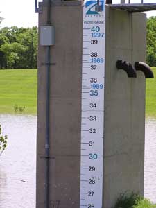
Flood crest predictions for Fargo jumped three feet in a week, with the National Weather Service predicting a 50 percent chance the Red River will hit 38 feet by mid-April.
By: Helmut Schmidt, INFORUM
Flood crest predictions for Fargo jumped three feet in a week, with the National Weather Service predicting a 50 percent chance the Red River will hit 38 feet by mid-April.
If that happens, it would become the third-highest flood on record, said Tim Bertschi, a flood engineer for the U.S. Army Corps of Engineers.
“It’s a pretty serious outlook,” Bertschi said.
Fargo and Cass County emergency management officials met Friday to discuss the new flood estimate and go over the status of flood preparations from sandbags, pumps and dikes, to tetanus shots and emergency command centers.
“This is not the March Madness I anticipated,” Fargo Mayor Dennis Walaker said.
“What we’ve seen today here, it’s changed dramatically,” Walaker said of the flood outlook. “Is it time to be concerned, I think it is. … We’ve got issues.”
Major flood stage in Fargo starts at 30 feet. The highest recorded flood in Fargo was 39.5 feet in 1997, officials said.
The current outlook calls for a 10 percent chance of a flood of 40 feet or more, which City Engineer Mark Bittner said would be a challenge to fight.
“God must feel that we need a refresher course every 10 years or so. And we had one in 2006, and 2009 seems a little soon. But it is reminiscent of ’97,” Walaker said.
Bertschi said Red River Valley cities are more in danger of flooding thanks to the recent major snowfall.
“We can’t take another blizzard or much rainfall on the melt. They’re all right on the edge” of needing assistance, he said.
“I was surprised. I was a little bit shocked. When we talk of flood prediction levels of 38, 39 feet, that’s as high as we’ve been,” said Morgan Forness, principal and dean of students at Oak Grove Lutheran School.
The Fargo school was badly damaged when sandbag dikes gave way in the Oak Grove area and let the river swamp the school and many homes.
Walaker and Bittner are concerned about overland flooding in south and southwest Fargo, as waters from the Sheyenne and Wild Rice rivers are likely to break their banks and advance toward Fargo and the Red River.
“It appears the flows are coming out of the Sheyenne and Wild Rice much higher than they were in ’97,” Bittner said. “The breakout flows are the largest concern right now.”
“We’re going to have to put an awful lot of people to work. We’re going to have to spend a tremendous amount of money to protect our city and our people. If there’s any good in this, and it’s hard to see something good about another flood, is that it’s going to re-emphasize our need for flood protection. … We need permanent protection and we need to have that as soon as we possibly can,” Walaker said, a not-so-subtle call for support for the city’s $161 million Southside Flood Control Project.
Leon Schlafmann, Fargo’s emergency services coordinator, said the best scenario for the spring melt would be “38 degrees (during the day), cold at night from here on out and no more precipitation.”
Overall, Bittner is confident this flood fight can be won, thanks to changes made since 1997.
“Thirty-eight, 39 feet. We’ve done it in the past, so we can do it again,” Bittner said.
At 1 p.m. today, Sen. Byron Dorgan will hold a meeting at Fargo’s City Hall to discuss flood fighting issues in the Valley.
Another city/county flood preparation meeting will be held 8 a.m. Friday at Fargo City Hall.
For more flood information, go online to:
www.cityoffargo.com/Flood09.